-
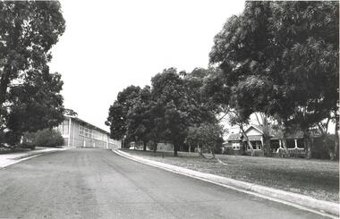
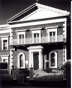 St Patrick's Old Collegians Association (SPOCA)
Photograph - Buildings, SPJC, Exterior, 1969 Series, 7
-
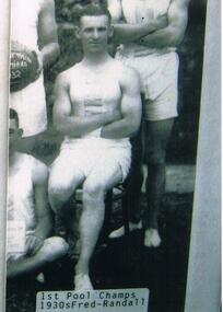 Bendigo Historical Society Inc.
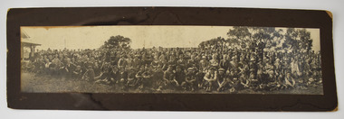
Photograph - VAL CAMPBELL COLLECTION: PHOTOGRAPH OF FRED RANDALL, 1930s
Black and white photo of Fred Randall seated outside on a chair and in the company of three others. They are all dressed in shorts and singlets. Written on the front of the photo: 1st Pool Champs 1930s Fred Randall.recreations, sports, swimming -
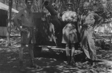 National Vietnam Veterans Museum (NVVM)
Photograph
Denis Gibbons (1937 – 2011) Trained with the Australian Army, before travelling to Vietnam in January 1966, Denis stayed with the 1st Australian Task Force in Nui Dat working as a photographer. For almost five years Gibbons toured with nine Australian infantry battalions, posting compelling war images from within many combat zones before being flown out in late November 1970 after sustaining injuries. The images held within the National Vietnam Veterans Museum make up the Gibbons Collection.A black and white photograph of gunners of 1st Field Regiment, Royal Australian Artillery at Nui Dat, Phuoc Tuy Province, South Vietnam pose for a formal photograph by their 105mm Howitzer. (Circa March 1967)photograph, 105mm howitzer, 1st australian field regiment, raa, 1st atf base, nui dat, phuoc tuy province, gibbons collection catalogue, denis gibbons, photographer, vietnam war -
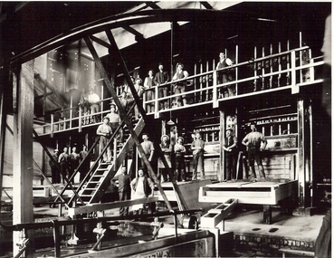 Bendigo Historical Society Inc.
Photograph - GOLDMINE BATTERY
Black and white photograph: 23 workers at goldmine battery. Stampers in background, 10 workers on boxes, amalgamation in foreground. Eleven workers on upper levels.mine, gold, miners underground., bendigo, mines and mining, miners, goldmine, battery, persons, group, male, workers, stampers, mining -
 Bendigo Historical Society Inc.
Photograph - LA TROBE UNIVERSITY BENDIGO COLLECTION: BENDIGO TEACHERS' COLLEGE
A black and white photograph of the drive in to Bendigo Teachers' College buildings C. 1960's. On the left is the administration block and on the right is the residence.bendigo, education, bendigo teachers' college, la trobe university bendigo collection, collection, education, bendigo, bendigo teachers' college, buildings, bendigo teachers' college grounds, bendigo teachers' college building, building, place, photo, photograph, photographs, photography, tertiary education, teacher training -
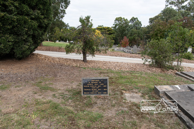 Eltham District Historical Society Inc
Photograph, Peter Pidgeon, Orford family graves, Eltham Cemetery, Victoria, 5 April 2021
One of Eltham's earliest settlers was James Orford. Born 1804 in Bedfordshire, the son of George, a carpenter and Lydia Barret, he and wife Sarah Amelia nee Moull (1807) arrived as Assisted Immigrants aboard the ship, ‘Orestes’, November 28, 1839 accompanied by their children, George (14), Mary Ann (11), and James (2). Originally settling in New South Wales, daughter Sarah Amelia was born at Braidwood in 1843 and son, Thomas Henry at Pambula in 1847. James was a carpenter who is known to have built the original gates to Eltham Cemetery. He died in 1869. Around 1890, his son Thomas Henry Orford was living in Pitt Street. Following the death of his wife Helen in 1899, Thomas was appointed by Joseph Panton to look after ‘Panton Park’, a 429-acre bushland property at the fork of Reynolds and Laughing Waters Roads, extending down to the Yarra River. His work entailed ringbarking the manna gums on the property to clear the land for pasture. Thomas lived in a slab hut with his son Ernie, who helped with the work. When Gordon Lyon purchased Panton Park in 1908, Thomas then worked for Lyon at both Panton Park and at ‘Banyule’, Lyon's stud farm at Heidelberg. In 1915 Lyon gave Thomas six acres of land in Reynolds Road with a two-roomed cottage. Thomas died in 1944 and is buried in Eltham Cemetery with his wife and his parents. Another of James Orford's sons was James Matthias Orford. He tried to grow food on land at the end of Laughing Waters Road, but without success. Reputedly the Wurundjeri taught him to swim. He was once imprisoned; when his friend Constable Lawlor invited him to inspect the new bluestone lock-up, Lawlor locked him in and wouldn't release him until he was promised two gallons of beer! ORFORD In Memory Of James 1804 -1869 Sarah Amelia 1807 - 1897 Their son Thomas Henry 1847 - 1944 His wife Helen Amelia 1854 - 1899Born Digitaleltham cemetery, gravestones, helen amelia orford, james orford, sarah amelia orford, thomas henry orford -
 Lakes Entrance Regional Historical Society (operating as Lakes Entrance History Centre & Museum)
Photograph, Lakes Post Newspaper, 1/05/1995 12:00:00 AM
Black and white photograph of Girl Guides Sue Roberts Reg Commissioner, Barb McGuire, Bev McColley taken at reunion East Gippsland Victoriaclothing -
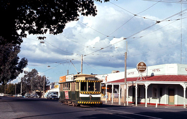 Ballarat Tramway Museum
Photograph - Digital image, John Ward, 22/03/1970 12:00:00 AM
Digital image of Bendigo tram 7 outward bound to Golden Square at corner of High and Laurel St Bendigo, with the United Kingdom Hotel in the background with a Carlton Draught sign. Photo by John Ward 22 March 1970. Slide title "00755 220370 SEC single truck tram 7 in High St at Robert St Golden Square Bendigo Vic"trams, tramways, bendigo, high st, golden square, tram 7 -
 Kew Historical Society Inc
Map, MMBW, MMBW Plan No.67 Kew, 1900-1910
The Melbourne and Metropolitan Board of Works (MMBW) was established by an act of the Victorian Parliament in 1890 to prepare for and to implement a sewerage and water reticulation system across what was then inner Melbourne, its surrounding and middle distance suburbs, including Kew. The MMBW was disbanded in 1991.The map collection of the Kew Historical Society has at its core the historic maps assembled and originally stored in the City Engineer's Department of the City of Kew. These include maps in a number of scales. The vast majority of maps were produced by the MMBW in the first two decades of the twentieth century, and are solid working maps, backed by linen for durability. These maps are historically significant to Kew, the City of Boroondara and to the history of the development of state utilities in Victoria. A number of the Kew maps have additional details added by former municipal officers, including the levels reached by various floods. As these were working documents, information was added to them long after the period of their initial production and distribution.Early map of part of the Borough of Kew, created in the first decade of the twentieth century, at a scale 160 ft to 1 inch. The map covers what was then the north central part of Kew, bordered on its north by the Outer Circle Railway Spruzen and Beresford Avenues, in the west by Princess Street, in the south by High Street, and in the east by (about) Belford Road. The map shows the extent of urban development by that time, prominent institutions and the outlines of built structures in the municipality. Contour lines were added in ink to the map at a later stage.MELBOURNE AND METROPOLITAN BOARD OF WORKS / PLAN NO. 67 / KEW melbourne & metropolitan board of works, mmbw maps, mmbw plans, borough of kew, cartography -
Glenelg Shire Council Cultural Collection
Photograph, n.d
Port of Portland Authority Archievesport of portland archives, jack clayton, ship master, master of the ship -
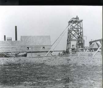 Clunes Museum
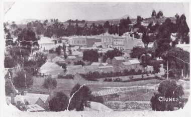
Photograph, C. NETTLETON, PHOTOGRAPHER, MELBOURNE, SOUTH CLUNES QUARTZ MINING, CIRCA 1865
.1 SEPIA PHOTOGRAPH OF SOUTH CLUNES QUARTZ MINING CO., CLUNES. 1865. .2 BLACK AND WHITE PHOTO PRINT .3 BLACK AND WHITE PHOTO PRINT OF POPPET HEADSOUTH CLUNES QUARTZ MINING COMPANY, REGISTERED, CLUNES.photographs, mining., south clunes quartz mining company -
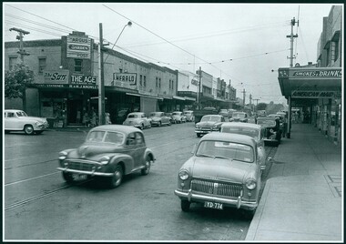 Camberwell Historical Society
Photograph, Camberwell, Victoria, view of Toorak Road and stores, c. 1950
Print of photograph of Middle Camberwell with inscription 'Camberwell, Victoria, view of Toorak road and stores, c. 1950' Camberwell, Victoria, view of Toorak road and stores, c. 1950camberwell -
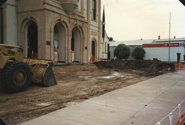 Stawell Historical Society Inc
Photograph, Stawell Town Hall -- Demolishing the forecourt 1995 -- Coloured
Stawell Town Hall Demolishing forecourt 1995stawell -
 Eltham District Historical Society Inc
Photograph, Liz Pidgeon, Heritage Excursion; Maroondah Aqueduct, 3 September 2016
Heritage Excursion - Maroondah Aqueduct Walk - Saturday 3rd September The Maroondah Aqueduct was once a major link in Melbourne’s water supply system. It was built between 1886 and 1891 to transfer water from the Watts River near Healesville to the Preston Reservoir. It was 66 km in length, made up of 41 km of open channel, 10 km of tunnel through hills and 15 km of pipeline across stream valleys known as inverted siphons. The section of the aqueduct through the Eltham area has been abandoned since the 1980s but the open channel has largely been retained. A recreational path follows the aqueduct reserve. For our excursion on 3rd September we intend to walk along the section of the aqueduct adjacent to Allendale Road. This is a section not visited on previous excursions and includes the transition from open channel to the inverted siphon across the Diamond Creek valley. Apart from the aqueduct itself the main feature of the walk is the extensive views across Eltham North and Diamond Creek. Along the way we will talk about the history of the aqueduct and the area. This easy walk is about 3 km return and will take 2 to 2.5 hours. It will start at 2pm at the junction of Allendale Road with Godber Road and Zig Zag Road North, officially Diamond Creek, but on the northern boundary of Eltham. (Melway ref.12 B10). Newsletter No., 229, August 2016 Abandoned and rusted house base probably purposed to water or feed cattle. Born Digitalmaroondah aqueduct, eltham north, activities, eltham district historical society, heritage excursion, bath, acqueduct trail -
 Buninyong & District Historical Society
Photograph - Original Photograph, Ann Beggs-Sunter, Lal Lal Railway Station, steamrail excursion stop, Oct. 1989, November 1995
historic transportColour photo, Lal Lal Railway Station, steamrail excursion stop with steam train, Oct. 1989lal lal station, ballarat geelong railway, steam train -
Glenelg Shire Council Cultural Collection
Photograph - Photograph - Portland Harbour Trust - Engineer's office from Cliff St Bridge 23/2/53, 1953
Port of Portland Authority archivesFront: ENGINEER'S OFFICE FROM CLIFF ST. BRIDGE 23/2/53 (lower centre) Back: P.H.T./ Print No. 3/15 Neg. No 141/ Date taken 23.2.53./ SUBJECT./ % (Ink stamp with blue pen and pencil additions, centre)port of portland archives -
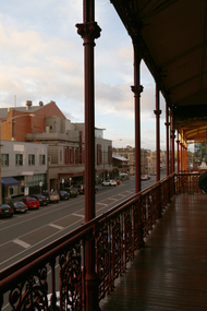 Old Colonists' Association of Ballarat Inc.
Photograph, Clare Gervasoni, View from the Balcony of the Ballarat Old Colonists' Hall, 2017, 23/03/2017
The Old Colonists' Hall opened in 1887.View down Lydiard Street North from the verandah of the Old Colonists' Hall.ballarat old colonists' club, ballarat old colonists' hall, balcony, lydiard street -
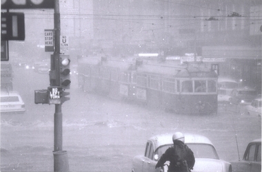 Melbourne Tram Museum
Photograph - Set of 9 Black & White Photograph/s, Ray Marsh, CBD Melbourne in 17 Feb. 1972 - floods, 1970's
Set of seven black and white photographs of Ray Marsh, of the flooding that occurred in the centre of the CBD Melbourne in 17 Feb. 1972. See Timeline History of Melbourne Trams - Barry George et al. .1 - 876 and two other trams, inbound, Bourke - Elizabeth at the height of the downpour. .2 - ditto, after the rain - looking east, with Dunklings in the view. .3 - W2, route 49, Little Collins and Swanston St looking west. Has a sign advertising Bush walking and sporting equipment above. .4 - W2 591 - north bound in Elizabeth St Essendon, route 49 looking south at corner of Collins St. Digital image of The Age article for the event supplied by Mal Rowe 4/12/12 by e-mail. 2nd copies of .2, .3 and .4 added ex donation of Keith Kings. .7 - Looking south from Bourke St / Elizabeth St. .8 - Bourke St at Elizabeth St with W6 976 and 992 in Bourke St on their way to Spencer St. .9 - Line up of trams in Bourke St (looking west) tailed by W6 999,. route 88. - two copies held. See Reg Item 5995 for photos of Flinders St at Market St. and 6099 for other photos.Details of the event written on the back of photos collected by Keith Kings and the Ray Marsh stamp in green ink with his address details.trams, tramways, melbourne, flooding, elizabeth st, bourke st, tram 876, tram 591, tram 976, tram 992, tram 999 -
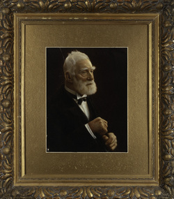 Kew Historical Society Inc
Photograph, James Venn Morgan, c.1905
James Venn Morgan was known affectionately as ‘The Father of Kew’. Born in Somersetshire on February 21, 1823, he sailed to Australia in April, 1851. James V. Morgan, was a member of one of the first parties to leave for the diggings. At Chewton, near Castlemaine his party tried their luck in an abandoned shaft, and in two weeks returned to Melbourne after having won 35lb weight of gold. James Venn Morgan was content with his success, and induced his partners to invest their money with him in land. After obtaining the advice of a friend, the party negotiated with Mr Samuel Watts, of Collingwood, who had recently purchased land from the Crown, and from him they took over at £15 an acre about 32 acres of land in the district that is now known as Kew. This land extended from where the Kew Post-office now stands to the locality of the Boroondara Cemetery. Here it was that Mr Morgan decided to settle, and, after having had the land surveyed, the partners apportioned it by drawing straws for the four sections into which it had been divided. One of them sold his holding later in the year for £100 an acre, and was sorry for it afterwards. In 1853 Mr. Morgan built the first house in Kew, and this house is the one in which he still resides. Here with his wife, he settled down to market gardening and dairying. So successful was the new venture that he induced his father and other members of the family to come out to Australia to assist him. Gradually the district became settled, Mr. Morgan parted with a portion of his holding, and subdivided and built on the remainder, which he still retained. In 1884 he found himself in a position to retire from active business.He celebrated his 100th birthday in 1923. He was later to die in the same year. The Argus, 17 January 1923.Rare and historic hand-tinted framed portrait of one of the founding pioneers of the district.Hand tinted photograph in a gilt frame of the Kew pioneer James Venn Morgan (1823-1923).james venn morgan, kew - pioneer families, kew - landowners -
 Stawell Historical Society Inc
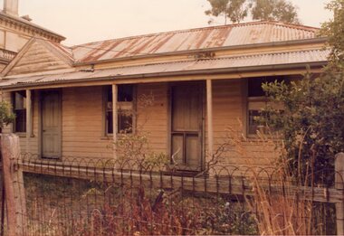
Photograph, Miss Molan's Patrick Street
Miss Molan's (From Deep Lead) Patrick StreetColour Photograph: Weatherboard House with verandah, Iron roof. Two doors and two windowsstawell residence homes -
Lakes Entrance Regional Historical Society (operating as Lakes Entrance History Centre & Museum)
Photograph, Edie Jemmeson, 1927 c
This photograph was used in the 150 year Lakes Entrance 1858 to 2008 display as the before picture paired with colour photograph number 03727.1 as the after picture size 10 x 15 cm road now paved with many buildings showingBlack and white photograph of Palmers Road looking south towards the sand dunes and ocean, titree along the side of the road photographers shadow in foreground, Lakes Entrance Victoriaindustrial -
Glenelg Shire Council Cultural Collection
Photograph - Photograph - Portland Library, 2002
Coloured photo. Portland Library. -
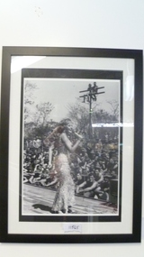 National Vietnam Veterans Museum (NVVM)
Photograph - Photograph, framed, Lorrae Desmond
Framed photo of the very popular Lorrae Desmond who did five concert tours to Vietnam. She also visited the injured and spent time chatting with soldiersDr. Denis Gibbons AM Collectionframed photo, lorrae desmond, denis gibbons -
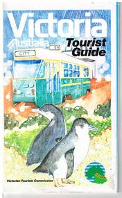 Melbourne Tram Museum
Map, Surveyor General for the Victorian Tourism Commission, "Victoria Australia Tourist Guide", 1985
Folded map of Victoria, showing in colour relief Victorian area, national parks, highways, towns, railways, airport, wine growing areas, towns with information centres, historic parks, ski fields. NSW and SA show major towns and highways. Front cover includes an image of a Z class tram and two penguins. Has town index. Folded 7 folds horizontally by 3 folds deep. On rear is a listing of locations with major tourist destinations provided. Provides location of VicTour offices. Prepared by the Surveyor General for the Victorian Tourism Commission, printed by the Government Printer, 4th edition 1985.trams, tramways, victoria, map, victour, tourism -
Charlton RSL Sub Branch
Article - Medal ribbon (only), Ribbon (only) for Australia Defence Medal
Ribbons for medals -
Port Melbourne Historical & Preservation Society
Photograph - Flag at half mast for Tom Hills, Port Melbourne Town Hall, John Ellis, Aug 1995
Taken at Waterside Workers' commemoration for Tom Hills (Union Headquarters), and afterward at the Town Hall, where a wreath was hung below his citizen of the year plaque in the foyer.Number 5 of a set of 6 photos: Town Hall with Port Melbourne flag at half mast for Tom Hillsport melbourne town hall, piers and wharves - waterside workers, tom hills -
 National Wool Museum
Photograph
Acquired when "Classweave Industries" closed down.24 ELSIE M DICKER/ PHOTOGRAPHER/... 5textile mills - staff woollen mills, classweave industries pty ltd federal woollen mills ltd, textile mills - staff, woollen mills -
 Kew Historical Society Inc
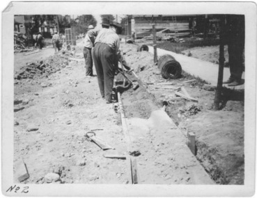
Photograph - Instructional photograph No.2: Using concrete for street kerbs, Portland Cement Association, 1921
One of seven photographs produced by the Portland Cement Association in 1921 showing how concrete kerbs could be created. Portland Cement Association (PCA) was founded in 1916. From 1917, the association actively promoted the benefits of concrete for road works in Australian newspapers. In the nineteenth century in Melbourne (Vic.) 'made roads' typically had gutters and kerbing lined with bluestone.The photographs are important evidence of the availability of instructional models for the use of concrete in street works in Victoria. While the photographs date from the early 1920s, the use of concrete for kerbing did not reach its maturity until after World War 2. The photos demonstrate knowledge about and the use of concrete in street works in a major Melbourne municipality at an early period.Black and white photograph with printed instructions on the reverse showing the production of concrete kerbing on 67th Street, West Allis, Milwaukee, Wisconsin (USA). The photograph was produced by the Portland Cement Association of Chicago in 1921 and used within the Chief Engineer's Department of the City of Kew (Vic.)."2nd - Tamping Concrete into Approximate Contour"street works, kerbing, gutters, concrete, portland cement association -
Bialik College
Photograph (Item) - Bialik in the 1990s
Various events that occurred at the Bialik primary school levels from 1992-1994. Children are seen in dress-ups of superheroes and pirates, wearing winter clothes, doing actions as a group, playing twister, painting and playing group sports. For inquiries or access contact [email protected] photographs have minimal to no inscriptions on them. The digital marks indicate they were taken in various months from 1992 to 1994school, jewish school, bialik college, photographs, primary school, 1990s, 1992, 1993, 1994 -
 Clunes Museum
Photograph
.1 HAND COLOURED POSTCARD PHOTOGRAPH OF CLUNES SHOWING SUSPENSION BRIDE AT THE LOWER END OF FRASER STREET, CLUNES. .2 COLOURED PHOTOGRAPH OF THE SUSPENSION BRIDGE .3 BLACK AND WHITE COPY OF THE PHOTOGRAPHCLUNESlocal history, photography, photographs, bridges and buildings