Showing 99677 items
matching documentation
-
 Stawell Historical Society Inc
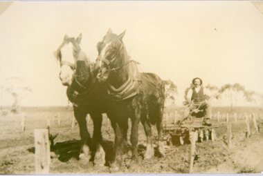
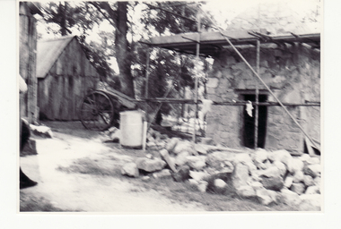
Photograph, Mr Joseph Mitchell at his farm at Deep Lead working with plough and horses
Joseph Mitchell at farm Deep Lead working with plough and horses amongst the vines.stawell deep lead -
 Ballarat Tramway Museum
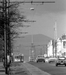
Photograph - Digital image, Peter Bruce, Sturt St into Drummond St North at 1.55pm, 1970s
Yields information about the Sturt St landscape looking east.Digital Image of a tram turning from Sturt St into Drummond St North at 1.55pm - long telephoto lens shot from about Ripon St, looking east. Mt Warrenheip in the far background. Photo taken by Peter Bruce 1970's and 1971 prior to the closure of the Ballarat System. Peter's Title of image: 1.55pmtrams, tramways, ballarat, sturt st, town hall, drummond st nth -
 Port Melbourne Historical & Preservation Society
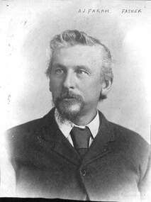
Photograph - A J Faram, 1900s
Arthur John Faram was a Real Estate Agent and Auctioneer in South Melbourne. He was married to Caroline Crook Faram and they had children Jack, Herbert, George, Louisa, Dick, Frank, Tom and Alice. Arthur died in 1914. Sons Tom, Dick and George established the Faram Bros ironmongery (hardware) store in Bay St which continued until 2007.From a group of four photos of the Faram family: A J Farambuilt environment - commercial, george faram, frank faram, richard faram, herbert faram, tom faram, louisa faram, alice faram, arthur john faram, caroline grook faram, bay street -
 Port Melbourne Historical & Preservation Society
Photograph - Melbourne City Mission, Jubilee Hall, Bay Street, Port Melbourne
Copied from Sister Norma Barnett's collection. Note Sr. Barnett's scooter in the foreground. Jubilee Hall was located behind the Fountain Inn, Bay to Crockford StreetsBlack and white lasercopy of photograph of the Melbourne City Mission at Jubilee Hall, Bay Street, c1960religion - melbourne city mission, sister norma jean barnett, jubilee hall -
 Bendigo Historical Society Inc.
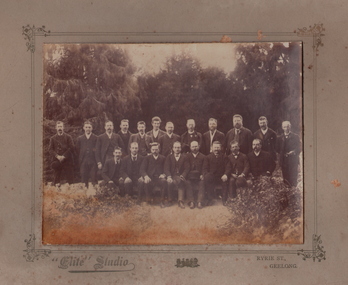
Photograph - GROUP OF MALES, 1900
Black and white photograph on grey board. Twenty adult males, outside. Large trees in background. All wearing 3-piece suits. Inscriptions: on board - 'Elite Studio, Ryrie Street, Geelong'. On back - 'ANA Convention at Geelong, Councillor JH Curnow of Bendigo, third from the left in front row'. History: Prev. Acc. No. GP76.Elite Studio, Ryrie Street, Geelongperson, group -
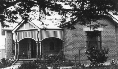 Stawell Historical Society Inc
Photograph, St. Matthew’s Presbyterian Church -- second manse 1923
St. Matthew’s Church Stawell second Manse built 1923. Single story brick house with small decorative timber verandah entrance with iron roof. A rocking horse is on the entrance verandah near front door. Large pine tree branches overhanging top section of photo with low plants in garden.New Manse built 1923stawell religion -
 Kew Historical Society Inc
Plan - Subdivision Plan, Shop Sites, East Kew, c.1927
Subdivision plans are historically important documents used as evidence of the growth of suburbs in Australia. They frequently provide information about when the land was sold on which a built structure was subsequently constructed as well as evidence relating to surveyors and real estate and financial agents. The numerous subdivision plans in the Kew Historical Society's collection represent working documents, ranging from the initial sketches made in planning a subdivision to printed plans on which auctioneers or agents listed the prices for which individual lots were sold. In a number of cases, the reverse of a subdivision plan in the collection includes a photograph of a house that was also for sale by the agent. These photographs provide significant heritage information relating house design and decoration, fencing and household gardens.This is one of a small number of subdivision plans for commercial property in the collection. The subdivision proposed to create six shop sites in High Street between the Harp of Erin and Station Street. The plan shows this stretch of High Street, East Kew already lined with shops that include the hotel on the corner, the new State Savings Bank, a dentist’s surgery and Lambert’s Store. The High Street Tram was to reach Burke Road in 1925, so the proposed subdivision must postdate that event, and the opening of the Bank in 1926.subdivision plans - east kew, high street - east kew -
 Stawell Historical Society Inc
Photograph - Aunde Album 29, Textile Plants, 2002
Aunde / Norwellan Textiles North Western Woolen Mills became Norwellan Textiles then AUNDEColour landscape photo: Map of the world dots of locations and countries maps.Textile AUNDE logo 19 Plants, 14 Countries.industry, aunde -
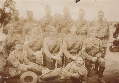 The Beechworth Burke Museum
Photograph, 1910
Lord Kitchener visited Seymour as part of his review of Australia's military capabilities. Lord Kitchener was Commander-in-Chief of the British Army at the time of his visit. At the invitation of Prime Minister Alfred Deakin, Kitchener visited Australia in 1909 to inspect the existing state of defence preparedness of the Commonwealth, and advise on the best means of providing Australia with a land defence. Kitchener’s report, submitted in February 1910, recommended the introduction of compulsory military training which was immediately adopted, as was the establishment of the Military College, Duntroon: It has been definitely decided that Seymour will be the site of the Kitchener camp. The troops which will make the strongest muster at the camp will be the Light Horse. This being so, the suitability of the chosen area for cavalry operations has necessarily had to be considered in selecting the site, and an additional factor is that Seymour is practically in the centre of the Light Horse districts. The country round Seymour is also suitable for artillery manoeurves, and there is no available area in the vicinity of Melbourne where these could be so well carried out. As it is considered that Field-Marshal Lord Kitchener will desire to see the troops on the move, the reason for choosing such a district as Seymour is apparent. The eight days to be devoted to the camp will be mainly occupied in moving the troops over a considerable area, and in carrying out certain tactical operations. Many of the sites recommended have been inspected by officers of the head quarter staff, and all that now remains is that the exact situation for the main camp should be selected, Major Luscombe will visit Seymour on Saturday to inspect the surround country, and select the most suitable places. The intention will be directed to sites closer to the town. Yea Chronicle (Yea, Vic), 9 December 1909. Black and white rectangular photograph printed on matte photographic paper and mounted on board.Obverse: Beechworth Light Horse (pen) / Kitchener Camp / Seymour / 1910 / Reverse: 8743 / Mrs R Scott / military album, burke museum, burke, beechworth, beechworth light horse, light horse, world war one, wwi, 1910 -
Glenelg Shire Council Cultural Collection
Photograph - Photograph - Scuba Diving, n.d
Port of Portland Authority ArchivesBack: '3' - blue textaport of portland archives -
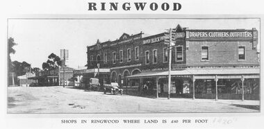 Ringwood and District Historical Society
Photograph, Maroondah Highway Central, Ringwood. Block Emporium, corner Adelaide Street and Main Street. c1924
Black and white photograph Typed below photograph: "Shops in Ringwood where land is £40 per foot - c1924". Written on rear of backing sheet: "Bloods' Store & Ringwood Coffee Palace, cnr. Main St. & Adelaide St c1924." -
Numurkah & District Historical Society
Photograph - Photo of grave
Black & White photo of a grave with a wreath inside a glass box -
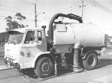 Melbourne Tram Museum
Photograph - Set of 6 Black & White Photograph/s, Melbourne & Metropolitan Tramways Board (MMTB), 1974
Series of six black and white photographs of "MacDonald Johnston" street sweeper, City of Preston on a Ford chassis. Possibly the MMTB was looking at a similar model and ascertaining whether it would be suitable for sweeping and vacuuming sand off tram track. On the outside of the box has "Street Cleaning Preston CC - Truck Johnson" Based on the Registration plate - LMB - a 1974 plate - see https://en.wikipedia.org/wiki/Vehicle_registration_plates_of_Victoria accessed 24/4/2020trams, tramways, city of preston, trackwork, cleaning, rails, ford motor company, macdonald johnston, mmtb -
Moorabbin Air Museum
Manual (Item) - Pilot's Notes for Beaufighter TFX Two Hercules XVII or XVIII Engines AP 1721H-PN, Pilot's Notes for Beaufighter TFX Two Hercules XVII or XVIII Engines
-
Moorabbin Air Museum
Manual (item) - De Havilland Gipsy Queen 70 Engine Service
Modification News Sheets 1631-2349 -
Moorabbin Air Museum
Manual - Maintenance Manual for the Gyro Magnetic Compass Mk.7A, Sperry Gyroscope Company
-
 Bendigo Historical Society Inc.
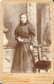
Photograph - FEMALE PORTRAIT, Ca 1900
sepia photograph on fawn board. Studio portrait of young woman standing beside chair. Young woman, long hair, leg of mutton sleeves. Holding book. Written on back of photo: Kate in black ink. Turnbull & Sons, Artistic Photographer, 10 Jamaica St, corner of Argyle Street, Glasgow.Turnbull & sons, Glasgow, Greenock, Kilmarnock and Belfastperson, individual, portrait female -
 Ringwood and District Historical Society
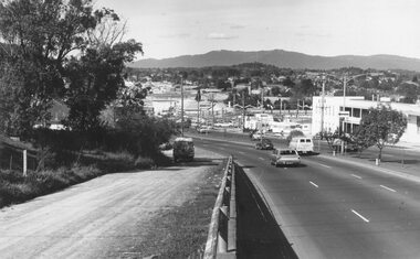
Photograph, Maroondah Highway West, Ringwood- 1974. Easterly view from Heatherdale Road
Black and white photograph (2 copies)Written on backing sheet, "View from Ringwood Hill - 1974". -
 Vision Australia
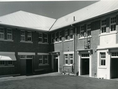
Photograph - Image, Queensland Industrial Institute for the Blind workshop, May 1970?
Two images taken of two possibly different buildings. The first appears to be the workshop owned by Queensland Industrial Institute for the Blind, after restoration; and the other, given similar images at State Archives Queensland, a new dormitory/kitchen/laundry block.2 x B/W photographs of a brick double storey buildingqueensland industrial institute for the blind, buildings -
 Halls Gap & Grampians Historical Society
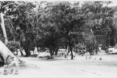
Photograph - B/W
Campsites along the road leading to the Halls Gap shops.The photo shoes tents and cars amongst the bush beside a dirt road. Three people can be seen sitting/reclining on a rug in the right foreground.recreation, camping -
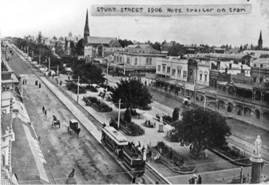 Ballarat Tramway Museum
Photograph - Black & White Photograph/s, 1906
Black and white photograph of Sturt St. looking west from Town Hall 1906. Shows a ESCo tram hauling an ex-horse trailer (spelt "trailer"). Has some other horse drawn vehicles in photo and a number of pedestrians. Shows the newly formed tramway road surface, poles etc. Has "Snows" store sign on left hand side of photograph and buildings along the north side of the Sturt St. Other buildings shown are William Day & Son, Walter Connell, Anderson & Morse coach builders. See also Reg Item No. 1671 for the same item, but with out the typed note stuck on the top edge.trams, tramways, esco, sturt st., ballarat -
Port Melbourne Historical & Preservation Society
Photograph - Spencer Street ferry, c. 1885
State library print of the Spencer St Ferry c 1885piers and wharves, spencer street -
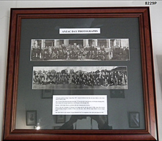 Bendigo Military Museum
Photograph - PHOTOGRAPH, FRAMED, ANZAC DAY PHOTOGRAPHS
In the top photo there are only a couple who are identifiable, 3rd from the left is Jack Swatton, (refer Cat No 6719.2P), 4th from left is George Lansell, (refer Cat No 8012P), there is one other from the left being possibly Les Morey The same Les Morey is in the bottom photo 8th from the left. These images are a copy of of the originals which were joined together and laminated as one. They were not taken the same year. Just by appearance the top photo is a number of years earlier than the bottom. There is an original of the top photo still in its cardboard cylinder for postage. Refer Cat No 8238.2TWO PHOTOGRAPHS WITHIN ONE FRAME. Anzac Day photos in black and white. Top Photograph - In front of Memorial Hall, Pall Mall (1949/1950) Lower Photograph - At the Upper Reserve (later renamed Queen Elizabeth Oval) At the bottom is a description. Frame- timber, mid brown colour with decorative edge. Glass front, Mount - dark green cardboard.On photos in the centre hand written is “Anzac Day 1951”brsl, smirsl, anzac day framed photos -
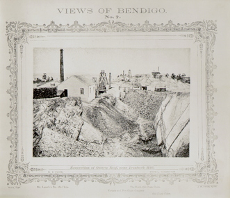 Bendigo Historical Society Inc.
Photograph - VIEWS OF BENDIGO - QUARTZ REEF
Black and white 'Views of Bendigo' No. 7. Excavation of Quartz Reef, near Ironbark Hill. Panorama of Mullock heaps and four mine sites. Copy of frames photo?. Inscriptions: Mine sites named - 'Lansell's 180 claim', 'Victoria and New Chum Company', 'North Old Chum Claim', 'Old Chum Mine'.NJ Caire, Sandhursttopic, mining -
 Federation University Historical Collection
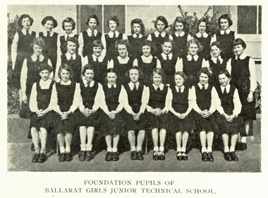
Photograph - Image - Black and white, Foundation Pupils of the Ballarat Girls Junior Technical School, 1951, 1951 (original)
In 1951 the first intake of students at the Ballarat Girls Junior Technical School occurred. The school was a part of the Ballarat School of MinesBlack and white image scanned from the 1951 Ballarat School of Mines Student Magazine. The image shows 28 girls in school uniform standing in front of a building. They are the foundation students of the Ballarat Girls' Junior technical School, also known as Central Girls' Technical School. Back Row: Lynette Robson, Lois Snibson, Janice Rogers, Joy Mills, Lynn Gilbert, Dawn Searle, Valerie Mills, Bonnie Cody (Simpson), Judith Bryan, Dawn Peacock. Middle Row: Margaret Paine, Carole Seddon, Valma Vincent, Raylee Bennets, Valerie Hughes, Kay Buchanan, Dorothy Robertson, Loris Gilbert, Dawn Lang. Front Row: Elizabeth Kinnane, Margaret Thompson, Lorraine Horwood, Brenda Beaumont, Yvonne Rowlands, Janette Sandwith, Dawn Parkes, Doreen New, Marion Marshall. ballarat school of mines, junior technical school, girls education, education, central technical school, ballarat girls junior technical school -
 Whitehorse Historical Society Inc.
Photograph, Smokehouse, Schwerkolt Cottage, 1976
Black and white photo of construction of Smokehouse at Schwerkolt Cottageschwerkolt cottage -
 City of Kingston
Photograph - Colour, 1998
The name Mordialloc was derived from the name Moody Yallock, which comes from the Bunurong language. The Bunurong Peoples are the Traditional Owners of this area. The name means “high water” or “high creek”. In 1839, colonial authorities declared the mouth of the creek, and an additional 830 odd acres as an Aboriginal Reserve, although this proclamation was never gazetted. The reserved land included part of the Carrum Carrum Swamp which was abundant with wild life and natural resources. Regular encroachments, including land sales which began in 1863, were made on the land until 1878 when the Reserve was declared closed, and the land was opened up to land sales. Market gardening and suburban house lots quickly began to develop, and Mordialloc became a renowned picnic and holiday site. Mordialloc Creek is a popular bay side destination for local and visitors, and is a site for boating, kayaking, fishing and swimming, along with many other activities.Colour photograph of Mordialloc Creek, looking inland.Small fishing and leisure boats are moored on either side of creek, with a view of the Mordialloc Bridge Hotel in the background.mordialloc, bunurong, traditional owners, suburbs, boats, fishing, waterways, hotel -
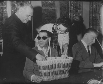 Vision Australia
Photograph - Image, Hubert Opperman visiting Jewish Blind Society day centre in London, 24/05/1965
Association for the Blind board member Hubert Opperman in his role as the Australian Minister for Immigration, visited the new Day Centre of the Jewish Blind Society at Stamford Hill, London. He discusses handwork with Mr Lew Dobrin and an instructress Mrs K. Amaral.B/W photograph of Hubert Opperman looking at a wicker basket made by a blind man.hubert opperman, association for the blind, jewish blind society -
Malmsbury Historical Society
Photograph (Item), Roadworks At Evans St Malmsbury C2000, Malmsbury c2000
Associated with - "Mhs, Mrsc?" Buildings - Bus Shelter -
 Surrey Hills Historical Society Collection
Photograph - 26 Park Road, Surrey Hills, On The Street Where You Live Project
Photos documenting this address as part of a photographic series undertaken by volunteer photographers during 2013 and 2014 for The Street Where You Live Project. This was organised through the Surrey Hills Neighbourhood Centre and covered the postcode 3127 in the cities of Boroondara and Whitehorse.These photos provide a snapshot of real estate in the suburbs of Mont Albert and Surrey Hills during a period of rapid change with many properties on large blocks demolished to create higher density residential development or renewal of single dwellings. At particular risk were properties not covered by heritage overlays, especially interwar housing and post 1950's housing.