-
 Bendigo Historical Society Inc.
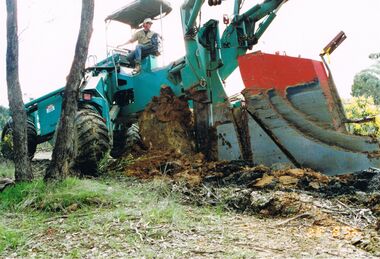
Photograph - CASTLEMAINE GAS COMPANY COLLECTION: PHOTO BENDIGO, 23/08/1996
Bendigo plough trail 23/08/1996. Worker on tractor ploughing trough track.Fujiorganisation, industry, gas and fuel -
 Clunes Museum
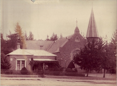
Photograph - PHOTOGRAPH METHODIST CHURCH
PHOTOGRAPH OF METHODIST CHURCH AND PARSONAGE, CLUNES. .1 SEPIA PHOTOGRAPH - ON REVERSE SIDE REG NO 180 (LADY ON A HORSE IN FRONT OF A 2 STOREY BUILDING) .2 COPY OF PHOTOGRAPHlocal history, photography, photographs, churches wesley -
 Bendigo Historical Society Inc.
Document - AULSEBROOK COLLECTION: STATE BANK BENDIGO OPENING INVITATION, 1978
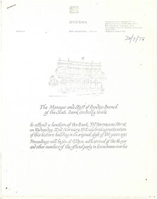
Aulsebrook Collection: State Bank, Bendigo Opening Invitation Title: The Manager and Staff of Bendigo Branch of the State Bank cordially invite… to attend a function at the Bank: 337 Hargreaves Street, Wednesday, 22nd February 1978, Celebrating restoration of this historic building in its original style of 100years ago. Proceedings will begin at 4:30pm with arrival of Mayor and other members of the official party in horsedrawn coaches. -A4,5 white pages, typed -Detailed booklet of information regarding event, history of the bank, information about the restoration project, and photocopy of newspaper clipping relevant to Bank. -
 Bendigo Historical Society Inc.
Photograph - BENDIGO ADVERTISER COLLECTION: BIKES, 1990s
Photograph: Man and racing bike in front of cannon On Rear: Rik McCaig RIK Round-up deskrecreations, sports, cycling, bendigo advertiser -
 Tarnagulla History Archive
Document - Postal Order: Flenley to Syme, 30th September 1867
Williams Family Collection. Probably filled out at Tarnagulla Post Office. Flenley was the Tarnagulla newsagent. The Symes (Ebenezer and David) were owners of The Age Newspaper, though Ebenezer had died in 1860. A postal money order for funds (one pound, 19 shillings, 6 pence) sent from H.M. Flenley of Tarnagulla to E & D Syme in Melbourne. tarnagulla, the age, media -
 Melbourne Tram Museum
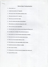
Document - Instruction, Swanston Trams, "Malvern Depot Training Questions", c2000
Instruction - set of 8 A4 sheets, titled "Malvern Depot Training Questions", includes a drawing of a Z3 tram, safety check list, includes D and D2, preparing trams, incident and accident collision quiz.trams, tramways, malvern depot, drivers, training, safety -
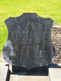 Ballarat Heritage Services
Photograph - Photograph - Colour, Clare Gervasoni, Headstone of Maurice Fitzgerald in the Tower Hill Cemetery, 2019, 03/01/2019
Colour photographs of the headstone of Maurice and Anne Fitzgerald in the Tower Hill Cemetery.In Loving Memory of Maurice Fitzgerald who died 17th December 1925 Aged 87 years Also his wife Anne Who died 29th July 1929 Aged 87 years Erected by their son Michael RIPtower hill cemetery, maurice fitzgerald, anne fitzgerald, michael fitzgerald -
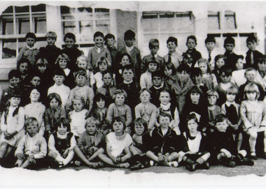
Glenelg Shire Council Cultural Collection
Photograph - Photograph - Branxholme State School (no. 1978) Classes 1 - 4, 06/06/1939
Black and white photo of grades I - IV at Branxholme State school No. 1978 in 1939. Students sitting/standing in four rows against brick wall. Female teacher at each end of back row. Students in front row holding a board with 'BRANXHOLME S.S. 1978 GR 1 -IV 1939.' Photo mounted on grey board, darker grey borders around edge and photo.Back: Photographer's stampschool, pupils, class photography, branxholme state school, school 1978 -
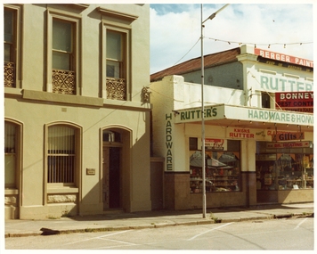 Stawell Historical Society Inc
Photograph, Pleasant Creek Special School, Gene & Bill O'Driscoll Solicitor (father son) & Mick & Nance Rutter Hardware Nov 1975, Nov 1975
Photographs taken by teacher at Pleasant Creek Training Centre to help train students in living skills and becoming familiar with what shops sold. Part of socializing students for leaving the training centre.Main Street Stawell. Showing shops and businesses in Main Street. education, shops, main street, streetscape -
 Bendigo Historical Society Inc.
Photograph - JORDAN COLLECTION: COLOUR PHOTO OF STREETSCAPE BENDIGO
Colour photo of streetscape Bendigo, see 3307.18 ( same photo )bendigo, streetscape, general street views -
 Lakes Entrance Regional Historical Society (operating as Lakes Entrance History Centre & Museum)
Photograph
Black and white photograph showing children from Infants, First and Second Grades at Lakes Entrance State School. Lakes Entrance VictoriaNames of some children on back: - Billy Risk, Hilda Risk, Pearl Blay, Jean Harbeck,schools -
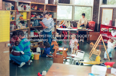 Eltham District Historical Society Inc
Photograph (Item) - Print, Harry Gilham, Toy Library in Action; People helping people voluntarily in Eltham, 1988
Harry Gilham 1988 Entrant No. 134 Ref: Series 34, Items 31, 32, 103, 104 SHIRE OF ELTHAM COMMUNITY PHOTOGRAPHIC SURVEY Photography is an artform which many of us practice, sometimes purely for artistic pursuit, sometimes to record the people and events in our lives. In 1988, as part of a local Bicentennial project, the Shire of Eltham conducted the Eltham Community Photographic Survey. Up to 100 entries were to be selected by a panel of photographers for entry into the Eltham Photographic Survey Exhibition. Entries had to be submitted by May 13, 1988. Entrants whose images were selected for the exhibition were contacted and requested to further submit an entry form providing entrant’s name, area of residence, age, and proposed captions. These details were then used to produce labels for the exhibition mounts. Where negatives had not been supplied, these were requested to support the display of printed enlargements mounted on 10” x 8” cardboard. The mounted prints were made available post exhibition for sale at $8.50 each for colour prints and $7.00 for B&W prints. Residents in the Shire were invited to collect a free roll of film and take a photograph of what they either liked or did not like about the area. A total of 160 entrants submitted multiple entries for the exhibition. Of those selected for exhibition, entrants ranged in age from 9 to 70 years. All custom colour and black and white printing for the exhibition was completed by Wattle Studios of Eltham. The Eltham Photographic Survey was jointly auspiced by the Shire of Eltham and Wattle Studios, of 953 Main Road, Eltham. The project was greatly assisted by: • David McRitchie, Media Studies Lecturer Victoria College, Rusden Campus. • Ian and Annette Toohill of Wattle Studios • Tracy Naughton, Eltham Community Arts Officer • Neville Emerson Pty. Ltd. • Superior Press, Eltham • Kodak Australasia Pty. Ltd. • Agfa Gevaert Ltd. • Townsend Colourtech Pty. Ltd. • The Australian Bicentennial Authority • Eleanor Bowers, Secretary, Eltham Arts Council The exhibition was placed on display in the Woolworths Arcade, Eltham between Monday June 6th and Saturday June 11, 1988. It was also intended to hold the exhibition at a venue in the Shire’s North Riding from Monday, June 20 to Friday June 24. It was then displayed at the Were Street Theatre, Montmorency from Friday, June 24 to Thursday, July 7. Series 34: Eltham Community Photographic Survey 1988 - Prints & Documentation Series consists of 117 photographs of Shire scenes taken by members of the community. Items I - 41 are larger photographs mounted on card, which were exhibited. Items 42 - 117 are unmounted copies, alternative takes and other entries. Corresponding negatives contained in Series 35: Eltham Community Photographic Survey 1988 – Negatives which consists of 267 colour and B&W negatives and one colour slide of Shire scenes taken by members of the community. The negatives are arranged by the entrant number of the photographer. The Eltham Community Photographic Survey collection is significant to the local community as it was curated by the local community - ordinary people of all ages - representing what they liked and did not like in the area where they lived. It represents an unfiltered representation of the Shire of Eltham as it was in 1988. It also represents one of many projects as part of the national programme of events and celebrations to commemorate the bicentenary. It is a time capsule of life in the 1980s of this urban and rural municipality in Melbourne's north. Front: Entrant No. and name on printed label Rear: Entrant No., name and address on printed label; also 'Series 34' and the 'Item No.' in pencilshire of eltham archives, bicentennial project, eltham, eltham community photographic survey, eltham photographic survey exhibition, series 34, series 35, eltham toy library, film - kodak ga 100 5095, harry gilham, scan - 35mm negative -
Stawell Historical Society Inc
Archive - Books & Papers, Stawell Rifle Club Records Minute books
Rifle Club existed from at least 1880's in Stawell 4271-1 Minute Book 7 May 1885 - 7 June 1899 4272-2 Minute Book 3 May 1907 - 11 October 1910 4272-3 Minute Book 12 July 1915 - 21 March 1921 4272-4 Minute Book 12 March 1917 - 21 January 1947 4272-5 Minute Book 20 May 1947 - 24 March 1960 4272-6 Correspondence Carbon Book 2 August 1957 26 Febuary 1978 4272-7 Minute Book 9 July 1960 - 15 March 1986 4272-8 Minute Book 7 April 1986 - 1 December 2001 4272-9 Minute Book 19 January 2002 - 9 June 2017Series of Ledgers 9 in all.sport -
Federation University Historical Collection
Document, Ken Clements, Clunes School of Mines Research, 2003
Research notes on the Clunes Campus of the Ballarat School of Mines {known as the Clunes School of Mines).clunes school of mines, rivett henry bland, ballarat school of mines -
 Mission to Seafarers Victoria
photograph - Photograph, Colour, Volunteers at the Hastings Seafarer Centre
-
Bendigo Historical Society Inc.
Document - INVITATION - BENDIGO PHILHARMONIC SOCIETY, 21/07/1971
Cream invitation with brown printing inviting the holder to a Social Evening of the Bendigo Philharmonic Society at the A. N. A. hall, on Friday, May 4th. Alex. Hamilton, Hon. Sec. Card is shaped with embossed vines around the edges.document, invitations, social evening, invitation, bendigo philharmonic society -
 Eltham District Historical Society Inc
Photograph - Aerial Photograph, Landata, Eltham; Crown Allotment 15, Section 5, Parish of Nillumbik (Stokes Orchard Estate), Apr, 1963
Centred on present day Diosma Rd, Stokes Pl, Nyora Rd and Eucalyptus Rd Historic Aerial Imagery Source: Landata.vic.gov.au Aerial Photo Details: Project No :486 Project : MELBOURNE (1963) PROJECT Run : 6 Frame : 122 Date : 04/1963 Film Type : B/W Camera : RC8 Flying Height : 5100 Scale : 9600 Film Number : 1805 GDA2020 : 37°43'12"S, 145°09'32"E MGA2020 : 337723, 5823642 (55) Melways : 22 B6 (ed. 42) A History of the Development of Crown Allotment 15, Section 5, Parish of Nillumbik – Stokes Orchard Crown Allotment 15, Section 5, Parish of Nillumbik (CA15) is a square allotment of 158 acres or approximately a quarter of a square mile. It lies just beyond the eastern end of Pitt Street, south of Nyora Road to the northern end of Eucalyptus Road and extends east from Eucalyptus Road to Reynolds Road. The topography of CA15 is generally steep, sloping up to a hill near the centre of the land, the ridgeline passing through the properties along the southern side of Diosma Road. Eucalyptus Road is a straight north-south road with its northern end at the north west corner of CA15. Until the end of the 1970s this road was an un-named Government Road and was largely not open to traffic. With residential development in the 1970s the road was constructed, and the council allocated the name obviously in recognition of the predominant species of the local bushland. CA15 was purchased from the Crown by George D’Arley Boursiquot, a prominent Melbourne printer, on 28th October 1852. On November 23, 1922, former Member for Gippsland and Melbourne Real Estate Agent, Hubert Patrick Keogh purchased the allotment then sold it March 13, 1925, to local farmer, Robert David Taylor, a former Shire of Eltham Councillor (1911-1920) and Shire President (1919). Taylor had extensive land holdings stretching west towards Bible Street and Main Road. The Taylor home was situated at the top of the hill in Bible Street at present day 82 Bible Street. At the time of Taylor’s purchase in 1925, CA15 was subdivided into 48 lots that could be described as small rural properties or large residential lots. A typical lot size was one hectare or 2.5 acres. The subdivision created two roads, Nyora Road, and Diosma Road, each following an irregular alignment between Eucalyptus and Reynolds Roads. However, the lots were not sold off separately nor were the roads constructed. The land effectively remained as one parcel for many further years. Robert David Taylor died November 30, 1934, and probate was granted to his son of the same name, Robert David Taylor of Bible Street, Salesman and William McLelland Vance Taylor of 73 Emmeline Street, Northcote, Clerk, with the transfer of the land into their names on July 8, 1935. Frank Stokes worked as a qualified accountant at Kennons leather factory in Burnley, while living at 1 Thomas Street, Mitcham. He suffered from migraines and wanted to return to working the land (he had previously worked on farms and orchards since coming to Australia from England in 1926, both in WA and Vic.). He first travelled to the district by train in July 1942 to find land with the intention to establish an orchard. By chance he met Arthur Bird of Bird Orchard (bounded by Pitt Street, Eucalyptus Road, and Wattle Grove) and they got talking over their common interest. Arthur put Frank up for the night and pointed out the land, 158 acres- part of the Taylor Estate- £900, Crown Allotment 15, Section 5, Parish of Nillumbik (CA15) somewhat diagonally opposite Bird Orchard. Stokes applied through the Riverina Agency to purchase the land who in turn applied for permission from Canberra to sell as there was a new government regulation introduced during the Second World War banning land sales except for immediate production. Stokes obtained a loan on his Mitcham house of £600 @ 5% and paid £450 deposit with quarterly payments of £15 spread over 5 years. Stokes was assisted and advised by Arthur Bird who farmed the neighbouring orchard. In early 1943 Stokes took possession and would catch the train out to Eltham on Fridays after work and began building a hut on the corner of Nyora Road and the Government Road (Eucalyptus Road) for shelter and to lock up tools. He established an orchard on the central western part of the land through the centre of which ran a natural waterway (part of the present-day linear park) and was able to pay a neighbour (Hawkins) to help with clearing and fencing 25 acres, and with a horse and single furrowed plough, planted approximately 2,500 fruit trees - cherries, peaches, plums, almonds, pears, apricots and lemons as well as a few apples and oranges; a massive task. Aerial photographs from the 1940s through to the 1990s clearly show the orchard with most of the larger CA15 site remaining as natural bushland. A huge problem was hares and rabbits eating all the new buds off the tiny trees. As well as laying poison he painted the trees with a mixture of cow manure and lime, often working by moonlight. Procurement of wire and wire netting was difficult because of the war but after much effort he obtained a permit from the Agricultural Department for supplies in March 1944. In February 1945 Stokes applied for a permit to build a “packing shed” as no house building was allowed. It was to be 33 feet x 21 feet and cost £312. It was constructed mostly from second-hand materials, which were hard to obtain, especially iron for roofing. Stokes finished work at Kennons on October 31, 1945, and in March 1946 he sold the family home at Mitcham for £1,230 plus £170 for furniture. On May 15, 1946, title to the CA15 property was issued to Frank Howard Alfred Stokes, Orchardist and Gladys Ethel Stokes, Married Woman, both of Pitt Street, Eltham. The family of five then moved into the very unfinished “packing shed” at Eltham, which was a struggle to weatherproof. Eventually rooms were divided off and lined with hessian bags and whitewashed. Their income was firewood (cut and sold), selling rockery stones and cut Sweet Bursaria. (It was discovered during the 1940s that Sweet Bursaria contained the sunscreen compound Aesculin. The RAAF utilised this compound from Sweet Bursaria during WW2 for pilots and gunners.) The orchard’s first fruit sale was a half-case of Le Vanq peaches in December 1947 for the price of 8 shillings. In 1956 plans for house were drawn and Glen Iris bricks purchased (1956 Olympic Rings variant). The building of the house commenced in 1957 - 12 feet of original packing shed was removed – and was completed in 1959. Water was connected from newly built pressure storage on the property at the end of 1959 and the electricity connection for the first time at 3pm on April 29, 1960. The house remains to present day (somewhat modified) at 1 Nyora Road, home to Nyora Studio Gallery. On occasions, spare remnants of the 1956 bricks have been known to be unearthed in gardens on the estate as they were utilised by Frank Stokes to fill in rabbit holes. On May 26, 1950, a parcel of land was compulsorily acquired by the Melbourne and Metropolitan Board of Works on the hilltop to establish an easement for a high-level service reservoir to augment Eltham’s water supply. The project also included pipe tracks for the necessary water mains. The reservoir has now been superseded by higher level water tanks east of Reynolds Road and its former site is now a public reserve. On November 27, 1964, the State Electricity Commission served notice to compulsorily acquire a further parcel through the eastern part of the land for a major electricity transmission line that augmented supply from the La Trobe Valley to Melbourne. The easement was registered February 11, 1966. The easement was widened July 18, 1969 for a second transmission line to be constructed. In 1971 Melbourne Metropolitan Planning Scheme amendments adopted Nyora Road as the boundary between a residential zone to the north and a rural zone to the south. This determined the future development of the land. In the mid-1970s the Shire of Eltham divided the orchard into numerous rate-able parcel lots, the 48 lots having been established in 1925 and the subsequent rates assessment proved unsustainable for Stokes. He commenced selling lots outside the boundary of the orchard, north of Diosma and South of Nyora. However shortly later the land between Nyora and Diosma Roads and west of the electricity easement was sold and subdivided into residential lots, a housing development by Macquarie Builders and marketed as the Stokes Orchard Estate. New streets were created, and most were named after trees, although one, Stokes Place, commemorates the former owners. The development was undertaken in two stages; Stage 1 (1975) encompassing Scarlet Ash Court, Ironbark Close and Peppermint Grove bounded by Nyora and Eucalyptus roads and Stage 2 (1978) encompassing Stokes Place, Orchard Way, The Crest and The Lookout bound by Nyora and Diosma roads. The developer, Macquarie Builders went bankrupt shortly after the release of Stage 2 leaving many purchasers to fend for themselves and arrange for their own independent builders. There were also difficulties with sewerage for the land immediately south of Diosma Road and so the conventional residential lots were abandoned in favour of larger lots. The development of Orchard Way, The Crest and The Lookout did not proceed as planned and the proposed lots were incorporated into five-acre parcels instead. These included a low-density group housing development by the Graves family and the award winning Choong House (1983) with Gordon Ford developed garden immediately next door situated on the ridge of the hill nestled amongst the original bush, Eucalypt trees and Sweet Bursaria. In 1994, Nillumbik Shire Council applied Significant Environment and Significant Landscape overlays upon the properties on the south side of Diosma Road to ensure protection of this natural bush garden environment. With the arrival of the sewer along Diosma Road in the 1990s, most of these five-acre parcels have since been subdivided multiple times. The Choong house presently sits on a 2.7-acre property, which in 2022 Nillumbik Council nominated for Cultural Significance Heritage protection and is considered potentially significant at State level. The Stokes family were also associated with the Eltham Christian Church. In the 1970s this church had met in temporary premises in Eltham. Lots of the original 1925 subdivision remained south of Nyora Road and a number of these lots were utilized for the Eltham Christian School, which was established by the Eltham Christian Church in 1981. The school operated on this site until 2000. The premises are now used by The Vine Baptist Church. By the mid-1980s the whole of CA15 had been developed for residential and school purposes, except for the sections north of Diosma Road and between the transmission lines and Reynolds Road. Sewerage issues had been resolved for the section north of Diosma Road and in 1987 it was in the process of being subdivided into residential lots. The development coincided with the discovery of colonies of the rare and endangered Eltham Copper Butterfly on the site. This resulted in a community and political campaign to save the butterfly habitat. With the co-operation of the land developer the subdivision was altered to create two bushland reserves in the critical butterfly habitat areas. In the late 1980s the State Government was investigating options for establishing a metropolitan ring road link between Diamond Creek and Ringwood. The chosen route was adjacent to Reynolds Road and so this created a freeze on development of CA15 between Reynolds Road and the electricity easement. The ring road proposal was eventually abandoned, and this part of the land was subdivided into low density residential lots. Diosma Road has been discontinued at the electricity easement and the eastern part incorporated into View Mount Court with access from Reynolds Road. The whole of CA15 has now been developed for residential or associated purposes, ranging from conventional density to quite low density south of Nyora Road. Some remnants of the orchard remain, a few cherry trees on the Graves property and a lone apple tree in Stokes Place. The butterfly reserves comprise significant areas of remnant bushland. Linear reserves through the estate link with central Eltham via the Woodridge linear reserve and with Research along the electricity easement. CA15 as it exists today has a complicated history of rural use, Government acquisition, urban development, and community action. References: • “Stokes Orchard, an incomplete history”; Russell Yeoman with Doug Orford • Correspondence, Beryl Bradbury (nee Stokes) • Aerial Photographs, 1931-1991, Landata (landata.vic.gov.au) • Certificate of Title, Vol. 4930 Fol. 985900 • Plan Number LP 10859 aerial photo, diosma road, eltham copper butterfly, eucalyptus road, ironbark close, nyora road, peppermint grove, peter & elizabeth pidgeon collection, power transmission lines, reynolds road, scarlet ash court, stokes orchard estate, stokes place, woodridge estate, frank stokes -
Moorabbin Air Museum
Manual (Item) - Cessna 210 Service Manual Supplement To The Single Engine Aircraft Manual
Description: Cessna Technical Parts Level of Importance: World. -
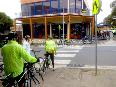 Eltham District Historical Society Inc
Photograph - Digital Photograph, Jim Connor, Commercial Place and Pryor Street, Eltham, 12 June 2015
jim connor collection, commercial place, cycling, eltham shopping centre, jock & eddie, pryor street -
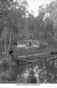 Eltham District Historical Society Inc
Photograph, The Rose Stereograph Company, A Pool, Eltham Road, Greensborough, c.1920
A boy of about ten years of age sits on the end of a fallen tree, which is resting in a natural pool in bushland. He is holding a stick gazing into the pool waters. He appears to be dressed in a schoolboy's uniform with close fitting short peaked cap, dark scarf or long sleeved jumper with polo neck and what appears to be a logo on the left breast, the ends of the sleeves turned over, dark shorts and dark long socks with ankle height lace up leather boots. The pool is located on the Eltham Road to Greensborough (present day Sherbourne, Karingal and St Helena roads) and is possibly part of the Karingal Yalloc somewhere near present day Ramptons Road Reserve. This glass plate negative was used to manufacture postcards (1:1 printing) for commercial sale by the Rose Sterograph Company and its subsidiaries. George Rose founded the Rose Stereograph Company in 1880 and was joined by Herbert (Bert) Cutts in the early 20th Century. The pair formed a lifetime working partnership and strong personal friendship. Assisted by George’s two sons, Herbert George and Walter, and later by Neil Cutts, the Rose Stereograph Company continued its operations for more than 140 years. The company was initially built on stereographs, but as cinema took over and stereographs fell out of fashion, the Rose Stereograph Company developed Australia’s first commercially viable photographic postcard business. Specialising in postcards of iconic historical moments and significant landmarks, The Rose Stereograph Company became a staple of the Australian travel industry.This remarkable collection of glass plate negatives, transparencies, and postcards – arguably Australia’s most significant photography collection outside of public hands – has been passed down through the generations, surviving war, relocation, and the harsh Victorian climate. The historic Rose Stereograph collection is the culmination of George Rose’s dream of capturing and preserving precious moments in time and remains the legacy of the Rose and Cutts families. It is with great sadness that the Cutts family says goodbye to a collection that spans five generations and 140 years. The Cutts family understands that for these historically important pieces to rest with one family is to deny others the pleasure of their custodianship.Glass Plate Negative Size: 9 x 14 cmA Pool, Eltham Road, Greensborougheltham, postcard, travel, rose stereograph company, glass plate negative, eltham road, greensborough, karingal road, karingal yallock, sherbourne road, st helena road, rampton's road reserve, schoolboy, peter and elizabeth pidgeon collection -
Moorabbin Air Museum
Manual (Item) - Cessna - Model 172 And Skyhawk Series 1969 And 1970 Service Manual
-
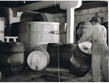 Bendigo Historical Society Inc.
Photograph - COHN BROTHERS COLLECTION: FACTORY
Photograph taken inside the factory and is of a man wearing a hat and overalls, rolling a barrel, his face cannot be seen. There are several barrels in the foreground and a large wooden vat behind them. The man is on the right hand side of the photoorganization, business, factory workers, cohn brothers , factory -
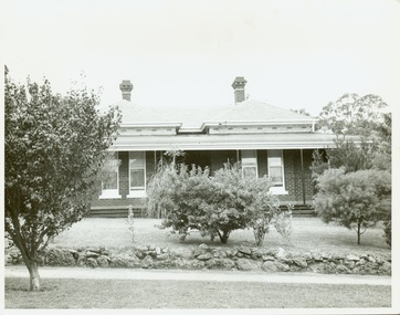 Kew Historical Society Inc
Photograph - Villa, Redmond Street (Kew), 1977
Original black and white print positive of a double fronted late Victorian Villa in Redmond Street, Kew. When the photograph was taken in 1977, it was the home of Mrs Darby.Reverse: "Elderly Kew resident['s home]. Taken by Trinity Grammar School Boys during a history study of People and Places in Kew 1978."victorian villas, victorian architecture, redmond street -- kew (vic.) -
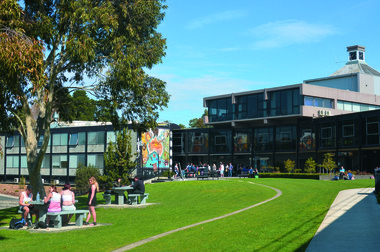 Federation University Historical Collection
Photograph - Digital Image, Federation University Gippsland Campus, 06/08/2013
Colour photograph of students at the Federation University Gippsland Campus Studentsgippsland campus, alumni, students, buildings, gippsland campus collection -
 St Patrick's Old Collegians Association (SPOCA)
Photograph - SPOCA, Class Reunions, 1966
-
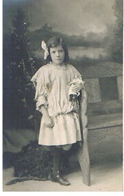 Bendigo Historical Society Inc.
Photograph - GILBERT RULE COLLECTION: PHOTO GLADYS RULE
Gilbert Rule Collection: black and white photo on postcard. Small girl, dressed in short dress with long black socks. Leaning on chair, and holding a soft toy in her left hand. Hair is parted on side with large soft bow on right hand side of head.Vincent Kelly, Bendigoperson, individual, gilbert rule -
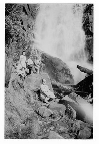 Marysville & District Historical Society
Photograph (item) - Black and white photograph, January 1950
An early black and white photograph of Steavenson Falls in Marysville in Victoria.An early black and white photograph of a group of people sitting at the base of Steavenson Falls in Marysville in Victoria. The Steavenson Falls is named after the Victoria Assistant Commissioner of Roads and Bridges, John Steavenson who arrived in Victoria in the early 1860's.Family Group Steavenson Falls Jan. 1950 From: Judith Macdonald Professional/ Color Papersteavenson falls, marysville, victoria, waterfalls, photograph, john steavenson -
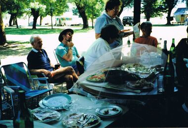 Bendigo Historical Society Inc.
Photograph - PETER ELLIS COLLECTION: PICNIC
Colour photograph. Picnic table set with food. People in camp chairs. Caravan. Back of photo has sticky tape stuck to it.photo, group, mixed group -
Glenelg Shire Council Cultural Collection
Photograph - Photograph - Aerial view of the Port of Portland from the south-west, c. 1967
Port of Portland Authority archives.Front: (no inscriptions) Back: Area available for silo extension and storageport of portland archives -
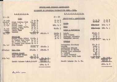 Bendigo Historical Society Inc.
Document - BERT GRAHAM COLLECTION: BENDIGO EAST PROGRESS ASSOCIATION, 1959-1982
Documents, Bert Graham Collection, Bendigo East Progress Association, Statements of trading, receipts and expenditure, hall expences,rates & electrical, wages,etc..bendigo, clubs, bendigo east progress association