-
 Eltham District Historical Society Inc
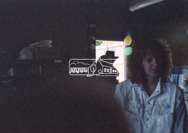
Negative - Photograph, Open Day, Eltham Living and Learning Centre, 7 Nov 1987
Open Day, Eltham Living and Learning Centre, part of the Eltham Community Festival activites, 7 Nov. 1987eltham, eltham festival, eltham living and learning centre, living and learning centre, open day -
 Ballarat Tramway Museum
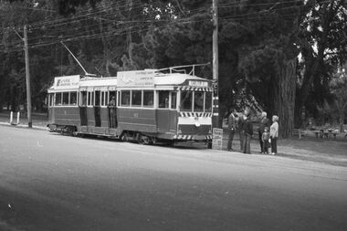
Negative, Bruce Herbert, "Bendigo and Ballarat Trams (AETA Convention) 30 Mar 1975", 30/03/1975 12:00:00 AM
Negative folder - made by ROW1 International of West Germany containing 40 No. 35 mm negatives of the AETA 1975 Convention visit to Ballarat and Bendigo on 30-3-1975. 17 photos of Ballarat and 23 of Bendigo. Ballarat photos: 1 - 40 at the Wendouree Parade crossing loop showing trams stop signage and AETA members standing at the front of the tram. 2 - distant view of 27 in the loop and the "wide roadway" 3 - view of 40 northbound about to nearing loop with various cars in the view. 4 - 40 about to enter loop with 27 in background. 5 - 40 and 27 at loop 6 - 40 at St Aidans Drive 7 - 14 and 27 at loop with 40 in the background 8 - 27 leaving loop 9 - 14 leaving loop 10 - General view showing cars and 40 in the loop, looking north. 11 - as for 1 12 - ditto 13 - 40 northbound, 27 southbound at loop 14 - 27 at loop 15 - 26, 14 and 28 at depot including 1 road. 16 - ditto with people viewing the trams - shows the overhead on 1 road. 17 - X41 and B80 on train at Spencer St, probably the train the group travelled on. trams, tramways, btps, ballarat, aeta, bendigo, bendigo trust, wendouree parade, depot, gardens loop, motor vehicles, tram 40 tram 27 tram 26 tram 14 tram 28 -
 Eltham District Historical Society Inc
Negative - Photograph, Eltham War Memorial Obelisk 1914-1918, cnr. Main Road and Bridge Street, c.1925
Located on what was referred to as Obelisk Corner, improvements have been been made since the unveiling in August 1919 with the provision of a stone retaining wall topped with a chain link and granite stone boundary, most likely in conjunction with improvements to the intersection into Main Road. Along with the use of the name Obelisk Corner, the Bridge Street bridge was also known as Obelisk Bridge. The Eltham Obelisk was originally located at the corner of Bridge and Main Roads in 1919. In 1943 (WW2) the local community commenced plans to establish the Eltham War Memorial, a living memorial to benefit the children as opposed to a one in stone as per the obelisk. The Eltham War Memorial Trust was established in 1945. In 1947 the Trust intended for the Obelisk to be relocated from Bridge Street and Main Road to the Garden of Remembrance which was planned as part of the Baby Health Centre which was to be the first of three buildings of the Eltham War Memorial to be built in 1951. In 1951 the Eltham RSL was invited to be represented on the Eltham War Memorial Trust. Around this time, with pending roadworks, the obelisk was relocated to the front garden of the Eltham RSL sub branch on Main Road for safe keeping. In 2007, a suggestion was proposed by Harry Gilham (President, EDHS) to John Cohen (ERSL) to claim a special site along with the historic Shillinglaw trees on the now vacant former Eltham Shire Office site adjacent to the Eltham War Memorial precinct for relocation of the obelisk. In 2010 following the financial collapse and sale of the Eltham RSL Sub-Branch property and amalgamation with the Montmorency Eltham RSL sub-branch, the location of the obelisk was again in immediate jepoardy and in conjunction with Nillumbik Shire Council, the obelisk was relocated in front of the Eltham War Memorial buildings in preparation for the Dawn Service on Anzac Day 2012.This photo forms part of a collection of photographs gathered by the Shire of Eltham for their centenary project book,"Pioneers and Painters: 100 years of the Shire of Eltham" by Alan Marshall (1971). The collection of over 500 images is held in partnership between Eltham District Historical Society and Yarra Plenty Regional Library (Eltham Library) and is now formally known as the 'The Shire of Eltham Pioneers Photograph Collection.' It is significant in being the first community sourced collection representing the places and people of the Shire's first one hundred years.Digital image 4 x 5 inch B&W Negsepp, shire of eltham pioneers photograph collection, eltham, main road, eltham war memorial, bridge street, obelisk, obelisk corner -
 Eltham District Historical Society Inc
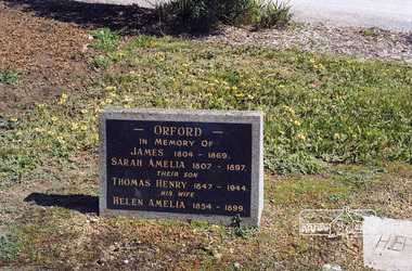
Negative - Photograph, Harry Gilham, Orford family graves, Eltham Cemetery, Victoria, Sep 2009
One of Eltham's earliest settlers was James Orford. Born 1804 in Bedfordshire, the son of George, a carpenter and Lydia Barret, he and wife Sarah Amelia nee Moull (1807) arrived as Assisted Immigrants aboard the ship, ‘Orestes’, November 28, 1839 accompanied by their children, George (14), Mary Ann (11), and James (2). Originally settling in New South Wales, daughter Sarah Amelia was born at Braidwood in 1843 and son, Thomas Henry at Pambula in 1847. James was a carpenter who is known to have built the original gates to Eltham Cemetery. He died in 1869. Around 1890, his son Thomas Henry Orford was living in Pitt Street. Following the death of his wife Helen in 1899, Thomas was appointed by Joseph Panton to look after ‘Panton Park’, a 429-acre bushland property at the fork of Reynolds and Laughing Waters Roads, extending down to the Yarra River. His work entailed ringbarking the manna gums on the property to clear the land for pasture. Thomas lived in a slab hut with his son Ernie, who helped with the work. When Gordon Lyon purchased Panton Park in 1908, Thomas then worked for Lyon at both Panton Park and at ‘Banyule’, Lyon's stud farm at Heidelberg. In 1915 Lyon gave Thomas six acres of land in Reynolds Road with a two-roomed cottage. Thomas died in 1944 and is buried in Eltham Cemetery with his wife and his parents. Another of James Orford's sons was James Matthias Orford. He tried to grow food on land at the end of Laughing Waters Road, but without success. Reputedly the Wurundjeri taught him to swim. He was once imprisoned; when his friend Constable Lawlor invited him to inspect the new bluestone lock-up, Lawlor locked him in and wouldn't release him until he was promised two gallons of beer! ORFORD In Memory Of James 1804 -1869 Sarah Amelia 1807 - 1897 Their son Thomas Henry 1847 - 1944 His wife Helen Amelia 1854 - 1899Roll of 35mm colour negative film, 6 stripsKodak GC 400-9eltham cemetery, gravestones, helen amelia orford, james orford, sarah amelia orford, thomas henry orford, cemetery gates -
 Wodonga & District Historical Society Inc
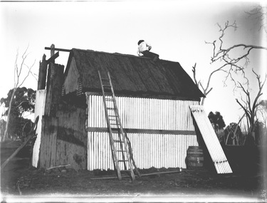
Negative - Haeusler Glass Negatives Collection - Mick Egan's house at Bonegilla, Victoria, c1910
The Wodonga Historical Society Haeusler Collection provides invaluable insight into life in late nineteenth and early twentieth century north east Victoria. The collection comprises manuscripts, personal artefacts used by the Haeusler family on their farm in Wodonga, and a set of glass negatives which offer a unique visual snapshot of the domestic and social lives of the Haeusler family and local Wodonga community. The Haeusler family migrated from Prussia (Germany) to South Australia in the 1840s and 1850s, before purchasing 100 acres of Crown Land made available under the Victorian Lands Act 1862 (also known as ‘Duffy’s Land Act’) in 1866 in what is now Wodonga West. The Haeusler family were one of several German families to migrate from South Australia to Wodonga in the 1860s. This digital image was produced from one of the glass negatives that form part of the collection, probably taken by Louis Haeusler (b.1887) with the photographic equipment in the Wodonga Historical Society Haeusler Collection. This item is unique and has well documented provenance and a known owner. It forms part of a significant and representative historical collection which reflects the local history of Wodonga. It contributes to our understanding of domestic and family life in early twentieth century Wodonga, as well as providing interpretative capacity for themes including local history and social history.Digital image created from the Haeusler Glass negative collection. Mick Egan's house in Bonegilla, Victoria under the final stages of construction. The house is made primarily from timber and corrugated iron. As a result of the construction and expansion of the Hume Weir, whatever may remain of the house is now below the waters of Lake Hume.wodonga pioneers, haeusler family, glass negatives, dry plate photography, bonegilla families, early victorian housing, mick egan -
 Bendigo Historical Society Inc.
Map - BENDIGO WEEROONA GASWORKS MAP/PLAN COLLECTION: LAY OUT OF NORTHERN SECTION, 1982
Plan: plan of Bendigo Weeroona Works, works lay out northern section. Written on bottom of plan: this tracing from old drawing ….(?) difficult to read, very faded.plan, bendigo, bendigo weeroona gasworks, maps: bendigo weeroona gasworks map/plan collection, gas works, plans -
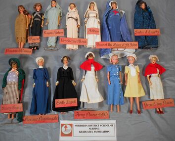 Northern District School of Nursing. Managed by Bendigo Historical Society Inc.
Education kit - Miniature Doll Collection, Nursing Through the Ages
Fourteen Miniature Models of Nurses from Primitive Era to 1980's. They were Dean Nancy Long's idea and she had them made. They were used for "Careers" information when visiting High Schools. In 1972 when the uniforms changed from traditional to more modern trend they created interest for prospective trainee nurses. Each has a frame and a name tag in Roman script Collection of fourteen miniature Dolls. These dolls were used as a teaching aid at the Northern District School of Nursing.Titles of Dollsnursing uniforms, educational equipment, careers -
Canterbury History Group
Map - Maling Road Built form Map, Ciy of Boroondara, 2015
Map copied from the 'Urban Planning Special Committee Agenda' Design and Development Overlay- Schedule 23 showing heritage property on Maling Road. Produced by The City of Boroondaracanterbury, maling road, heritage buildings, city of boroondara, urban planning special committee agenda, maps -
 Warrnambool and District Historical Society Inc.
Map - Tourist Map Collection: Warrnambool & District Tourist Maps, Philprint, Warrnambool
This is a diverse collection of Tourist Maps for the Warrnambool & District area. [.1] From information on this guide it dates from the mid 1970's. It appears to not have been commercially printed and includes details of attractions no longer operating in Warrnambool such as Warrnambool Aquarium and the Oasis Reptile Park and Zoo. [.2] Commercially printed Warrnambool tourist map (c mid 1980's) surrounded by advertisements for local businesses. [.3] Commercial printed December 1991 tourist map of Warrnambool and District includes a competition entry form [.4] Commercially printed tourist map aimed at children [.5] Walking map of Warrnambool and District [.6] Commercially printed Warrnambool tourist map (c mid 1980's) surrounded by advertisements for local businesses. This collection of maps from the mid 1970's to early 1990's gives an insight into what was available to assist tourists find their way around Warrnambool and District. They include advertisements for business operating during this period and include lists of available accommodation, eateries, and tourist attractions.[.1] Tourist Attractions In and Around Warrnambool two foolscap pages with two sides of type written information of local and district attractions. There is a Warrnambool City map with points of interest marked and a hand drawn district map; [.2]Commercially printed grid map of Warrnambool City surrounded by advertisements from local businesses. Reverse side has a district map and a map of the Warrnambool CBD surrounded by advertising. [.3] Brochure including small grid maps of Warrnambool and district listing accommodation providers and places of interest. Stylised blue & bright green design of Norfolk pines and sea. [.4] Children's treasure hunt map to Warrnambool There are two examples, one with blue edging (Jan 1986) and one with red edging (Aug 1993) Both have a circular logo with a stylised whale and lighthouse [.5] Walking maps of Warrnambool blue printed photo of four tourists walking coastline on the front cover. [.6] Commercially printed grid map of Warrnambool with a bright yellow inset of Warrnambool CBD main shopping centre. The map is surrounded by advertising for local businesses.warrnambool, tourist maps, warrnambool businesses, warrnambool accommodation -
Kew Historical Society Inc
Archive (series) - Subject File, Kew Historical Society, 'Houghton', Princess Street, 1960
Various partiesReference, Research, InformationSecondary Values (KHS Imposed Order)Small subject file which includes histories of the weatherboard house, Houghton (erected 1853, now demolished), which once stood in Princess Street near Ivy Grange. The file includes a typescript of the chapter on Houghton by Dorothy Rogers published in ‘Lovely Old Homes of Kew’ (1960) and an undated document written by Louisa Hamilton which provides some information about the early history of Houghton but also records the development behind Houghton of 14 self-contained units for war widows. A Vasey newsletter (Circular No.144, August 1984) includes a quote from 1960 relating to the opening of the flats by Hon Hugh Robertson, Minister for Social Services.kew historical society - archives, kew - history, houghton - princess street - kew (vic), mrs vasey obe, kitty gahan, annie bowden, vasey newsletterkew historical society - archives, kew - history, houghton - princess street - kew (vic), mrs vasey obe, kitty gahan, annie bowden, vasey newsletter -
Kew Historical Society Inc
Archive (Series) - Schools [Kew]
Various PartiesReference, Research, InformationArranged by Secondary Values (value of records to users)Kew is home to many different education institutions, many longstanding with extensive histories. The oldest still running school, the Kew State Primary School, began in 1872, with many influential private schools such as Xavier College and Methodist Ladies College being built and established within the next decades. Kew (and Boroondara by extension) is well-known for its quality of schooling compared with the rest of Melbourne, as well as it’s priciness as many private schools compete for students in such a small area. Kew is also home to Preshil, the first school of its experimental kind in the state. The file includes: Advertisements for many of the schools in Kew through newspapers, multiple newspaper articles, and a history of schools in Kew.schools – kew (vic.), xavier college – kew (vic.), methodist ladies college – kew (vic.), kew primary school – kew (vic.), kew high school – kew (vic.), kew east primary school – kew (vic.), genazzano college – kew (vic.), carey baptist grammar – kew (vic.), preshil – kew (vic.)schools – kew (vic.), xavier college – kew (vic.), methodist ladies college – kew (vic.), kew primary school – kew (vic.), kew high school – kew (vic.), kew east primary school – kew (vic.), genazzano college – kew (vic.), carey baptist grammar – kew (vic.), preshil – kew (vic.) -
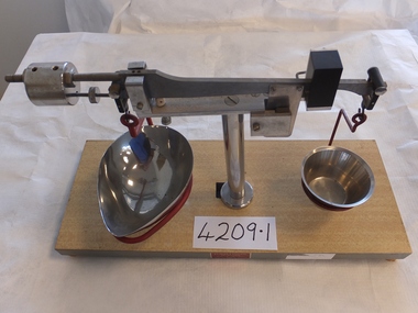 Stawell Historical Society Inc
Archive, Two sets of Scales (Pharmacy) Pleasant Creek Training Centre
stawell -
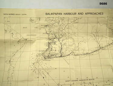 Bendigo Military Museum
Map - MAP, DUTCH BORNEO
Map identified height of land in area and depth of ocean on approached to Balikpapan Harbour. Identified piers, streets and defences and potentially used for landing or combat in the area. MAP PRODUCED BY 2/1 AUST ARMY TOPO SQN CO. Large Yellow paper map with scale of 1:36,000 of Dutch Borneo Balikpapan Harbour and it's approaches. Map folded into 8.balikpapan harbour, maps -
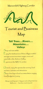 Marysville & District Historical Society
Map (Item) - Tourist and business map, Narbethong Community and Tourism Group, Narbethong Buxton Taggerty Tourist and Business Map, 04-2008
A tourist and business map of Narbethong, Buxton and Taggerty. This map was produced by the Narbethong Community and Tourism Group in April 2008. It was produced to promote the natural attractions, adventure activities and food trail from the Black Spur, through Narbethong, Buxton and Taggerty.A tourist and business map of Narbethong, Buxton and Taggerty.This publication has been produced by the Narbethong Community and Tourism/ Group (NCTG) to promote the natural attractions, adventure activities and food/ trail from the Black Spur, through Narbethong, Buxton and Taggerty./ the information provided in this publication has been supplied by the individual/ members. NCTG takes no responsibility for its accuracy./ April 2008narbethong, buxton, taggerty, victoria, australia, tourist and business map, narbethong community and tourism group, acheron valley, yarra track, wood's point, black spur, mystic mountains, the meeting of the waters, cathedral range, danico design counted cross stitch, things of sand & stone, buxton zoo nursery & oddz & enz, willowbank at taggerty, safe trek 4wd services, pnl 4wdriving, buxton trout and salmon farm, mystic mountains ski hire & outdoors, narbethong ski hire, highwood health centre, cathedral view natural therapies, narby cabinets, plants by shelian, gb timber, executive signs, rb automotive repairs, buxton car care, marysville towing & equipment hire, martyn slade building design, cathedral peak framing, black spur roadhouse & ski hire, tudor lodge roadhouse & ski hire, buxton roadhouse & persian bazzar, buxton post office general store & niche bar, igloo roadhouse, taggerty store, narby eggs, marapana agistment park, mantirri blueberry farm, carmyle farm, hazelwood hazelnuts, south cathedral lavender farm, cathedral cherries, black spur motel & caravan park, woodlands rainforest retreat, chestnut glade, black spur inn, wombat cottage, abbey lake luxury b & b spa cottages, blue views holiday cottages, camp narbethong, marapana farm stay b & b, mantirri blueberry farm b & b, little dene garden cottages, silverstream b & b cottages, nareen cabins, moondai farm b & b, south cathedral farm luxury b & b cottages, yarrolyn caravan park, sarsens rest, lomah retreat, pinjarra gardens, kingbilli country estate, henry viii manor house, buxton hotel, butters cafe of buxton, wagtail wines, little river wines, lanterns at willowbank, wirrawilla rainforest walk, wilhemina falls, the cascades -
Kew Historical Society Inc
Archive (Sub-series) - Subject File, Billabong - Willsmere Park, 1958
Various partiesReference, Research, InformationKHS OrderNewspaper articles/clippings relating to the desire to save the Billabong at Willsmere Park in Kew. The file includes articles with a more general focus relating to bike paths and Willsmere Park generally.billabong - willsmere park - kew east, billabongs - yarra riverbillabong - willsmere park - kew east, billabongs - yarra river -
Moorabbin Air Museum
Map (Item) - Environs of the Top End Map
-
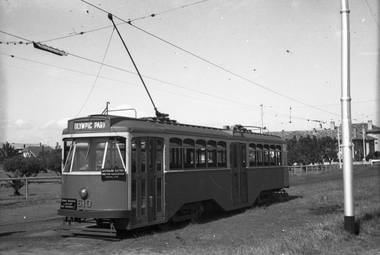 Melbourne Tram Museum
Negative, Wal Jack, mid 1950's
Black and white negative, by Wal Jack, Y1 610 of an AETA tour at Point Ormond, with destination of Olympic Park. Photo possibly mid 1950'strams, tramways, aeta tour, point ormond, y1 class, tram 610 -
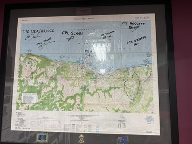 The 5th/6th Battalion Royal Victoria Regiment Historical Collection
Map - Honiara Map, Honiara West Special used by members of 5/6
Honiara West Special signed by 7 members of 5/6 RVR who were deployed on Operation AnodeThe Map is framed in the glass frame withe the Operation Anode patch, Australian Flag and 5/6 unit symbol displayed below the Map. It has been signed by 7 members of 5/6, each member's PMKey is also displayed on the Map -
Bendigo Historical Society Inc.
Map - BOROUGH OF EAGLEHAWK SHEET 2, 9/12/1902
Map: Borough of Eaglehawk, Sheet No, 2. Parish planmap, bendigo, parish plan, borough of eaglehawk -
 Wodonga & District Historical Society Inc
Negative - Haeusler Glass Negatives Collection - Man, two women and a child - unidentified, c1910
The Wodonga Historical Society Haeusler Collection provides invaluable insight into life in late nineteenth and early twentieth century north east Victoria. The collection comprises manuscripts, personal artefacts used by the Haeusler family on their farm in Wodonga, and a set of glass negatives which offer a unique visual snapshot of the domestic and social lives of the Haeusler family and local Wodonga community. The Haeusler family migrated from Prussia (Germany) to South Australia in the 1840s and 1850s, before purchasing 100 acres of Crown Land made available under the Victorian Lands Act 1862 (also known as ‘Duffy’s Land Act’) in 1866 in what is now Wodonga West. The Haeusler family were one of several German families to migrate from South Australia to Wodonga in the 1860s. This digital image was produced from one of the glass negatives that form part of the collection, probably taken by Louis Haeusler (b.1887) with the photographic equipment in the Wodonga Historical Society Haeusler Collection.This item is unique and has well documented provenance and a known owner. It forms part of a significant and representative historical collection which reflects the local history of Wodonga. It contributes to our understanding of domestic and family life in early twentieth century Wodonga, as well as providing interpretative capacity for themes including local history and social history.Digital image created from the Haeusler Glass negative collection. An unidentified man, two women and a child posing in front of a bushwodonga pioneers, haeusler family, glass negatives, dry plate photography -
Bendigo Historical Society Inc.
Map - YARRAYNE : COUNTY OF BENDIGO, 6-1-32
Map. Yarrayne, County of Bendigo, Janiember Easr, Pompapiel, Salisbury, Bridgewater, Salisbury West, Powlett. Photo-Lithographed at the Department of Lands and Survey, Melbourne. Price 2/-. 6-1-32.By authority H.J. Green, Govt.Printer. (number 31 in map cupboard 1)H.J. Green, Govt.Printer.map, bendigo, yarrayne -
Port Melbourne Historical & Preservation Society
Map - Albert Park, South Melbourne and part of Port Melbourne, MMBW
Melbourne and Metropolitan Board of Works Plan 9E-NE depicting Albert Park, S. Melbourne and (part of) Port Melbourne.mmbw, melbourne and metropolitan board of works -
Whitehorse Historical Society Inc.
Map, Broadbents map no 230, To and from Clifford Park, c1955
Map - To and From Clifford Park by Broadbents 1955 - 56 prepared for a scout jamboree.maps, eastern suburbs (melbourne), scout groups -
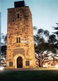 Eltham District Historical Society Inc
Negative - Photograph, Harry Gilham, Shire of Eltham War Memorial, Memorial Park, Kangaroo Ground, c.Apr 2002
Showing the new bronze plaques installed for the November 2001 re-dedication of the memorial as well as the floodlighting installed 1999.shire of eltham memorial park, driveway, kangaroo ground, floodlights, kangaroo ground tower, lighting, shire of eltham war memorial -
Glenelg Shire Council Cultural Collection
Negative - Negative - Portland Bird Sanctuary, ZILLAH MASCHMEDT, PHOTOGRAPHER, c. 1934
NEGATIVE FOR BLACK AND WHITE PHOTOGRAPH. Portland bird sanctuary. Water and reeds in foreground. Magazine Hill in the backgroundnegative, bird sanctuary, birdlife, waterfowl, wildlife -
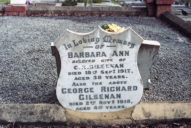 Eltham District Historical Society Inc
Negative - Photograph, Harry Gilham, Grave of Richard Edward Gilsenan and his wife, Harriet Eliza, Eltham Cemetery, Victoria, 1 Aug 2007
Richard Gilsenan was a retired schoolteacher living at “Rosebank” in Eltham, now the site of the Living and Learning Centre. In 1906, Eltham Primary School’s headmaster John Brown died, and Richard was brought out of retirement (briefly) to be acting headmaster. His son Harold was a junior teacher there at the time. Thereafter, Richard was Secretary of the Eltham Progress League and more importantly was a magistrate at the Eltham Court of Petty Sessions. Cases commonly brought before him included not sending a child to school (typical fine 5/- or eight hours in the lock-up), not having a child vaccinated (fixed fine 40/-), stealing fruit from an orchard, selling liquor out of hours, and offensive language and behaviour. Other miscellaneous cases were allowing cattle to wander, selling cigarettes to a minor, carelessly burning off rubbish on a hot windy day, dumping a dead horse in the Diamond Creek, and youths throwing ripe fruit at passers-by. Richard died in 1920 and is buried in Eltham Cemetery with his wife Harriet Eliza. In mourning his passing, his peers noted that his decisions had been given in a very fair way. Incidentally, his son Harold (the teacher) died in 1921 after being trampled by a horse while en route from Eltham to Cathkin (his then school). In Loving Memory Of Richard Edward Gilsenan Died 30th July 1920 Aged 73 years Also Harriet Eliza Beloved wife of above Died 7th Sept. 1933 Aged 78 years Sweet Rest And In Loving Memory Of Barbara Ann Beloved wide of G. R. Gilsenan Died 18th Sept. 1917 Aged 38 years Also the above George Richard Gilsenan Died 2nd Nov. 1918 Aged 40 yearseltham cemetery, gravestones, memorials, barbara ann gilsenan, george richard gilsenan, harriet eliza gilsenan, richard edward gilsenan -
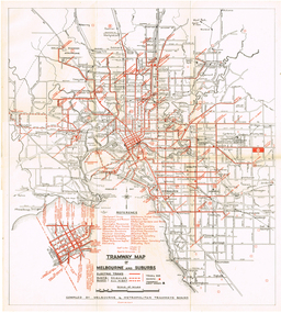 Melbourne Tram Museum
Map, "Tramway Map of Melbourne and Suburbs", c1952
Map of Melbourne's Tram and Bus routes, route destinations, MMTB Guest houses, all-night bus routes, depots, golf links and sporting grounds, rail lines, and location of major places of interest. Titled - "Tramway Map of Melbourne and Suburbs" - c1952, after the La Trobe or Latrobe St lines opened. Not known who produced the map. Does not give route numbers. See also Reg Item 2300 for an MMTB Map of the same era, 7315 for a similar version but without the guest houses, and 4525.1 for an MMTB Photograph.Yields information about Melbourne tram routes prior to Bourke St being built.Fold out map (6 sections), two colours. Has been removed from a book with the remnants of other paper in the top left-hand side.trams, tramways, melbourne, map, tram & bus services, all night services, mmtb, guest houses -
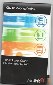 Melbourne Tram Museum
Map, Metlink, "City of Moonee Valley - Local Travel Guide - July 2008", Sep. 2008
Map, Guide book, Pamphlet, 21 fold, pocket size, titled "City of Moonee Valley - Local Travel Guide - July 2008" detailing public transport services in the City. Includes map of the tram, train networks, tickets information, tram traction , Connex SMS updates and info on Metlink including contact details. Has a detail map showing services in the city and adjacent overlap area of buses, trams and trains including route numbers. See Reg Item 2250 for City of Boroondara version.trams, tramways, city of moonee valley, map, guides, bus services, metlink, connex -
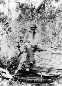 Eltham District Historical Society Inc
Negative - Photograph, Mr. J.L. Grimshaw; the man who found the first gold at Kinglake
J. L. Grimshaw, long time gold miner opened up the Kinglake Diggings in 1860. Reproduced on p95 of 'Pioneers & Painters'This photo forms part of a collection of photographs gathered by the Shire of Eltham for their centenary project book,"Pioneers and Painters: 100 years of the Shire of Eltham" by Alan Marshall (1971). The collection of over 500 images is held in partnership between Eltham District Historical Society and Yarra Plenty Regional Library (Eltham Library) and is now formally known as the 'The Shire of Eltham Pioneers Photograph Collection.' It is significant in being the first community sourced collection representing the places and people of the Shire's first one hundred years.Digital image 4 x 5 inch B&W Neg B&W Print 25 x 20 cm and 12.5 x 9 cmsepp, shire of eltham pioneers photograph collection, kinglake, j.l. grimshaw, gold miners, pioneers and painters, j.l grimshaw -
Whitehorse Historical Society Inc.
Map, City of Nunawading, c1980
Map of the City of Nunawading with list and location of 47 schools.Map of the City of Nunawading with list and location of 47 schools. Scale 1 mile = 3.75 inMap of the City of Nunawading with list and location of 47 schools. city of nunawading, maps, schools