-
 Tatura Irrigation & Wartime Camps Museum
Literary work - Autobiography, John Malcolm WELLER, 1970
An excerpt from the autobiography written in the 1970's by John Malcolm WELLER. a guard in Camp 13 and Graytown in 1942-1945. Clear front, grey back and side plastic folder containing 8 sheets of an excerpt from the autobiography of John Malcolm WELLERon side: donors name and address; Record of "Saddler Weller army guard at Camp 13 and Graytown 1942-1945.john malcolm weller, saddler weller, camp 13 murchison, graytown internment camp, army guards internment camps -
Bendigo Historical Society Inc.
Archive - THE ALLAN STEWART COLLECTION: PERSEVERANCE CORPORATION LTD, 1890-2001
DVD. Allan Stewart Collection. Pdf History of Fosterville from 1890 -2001. -
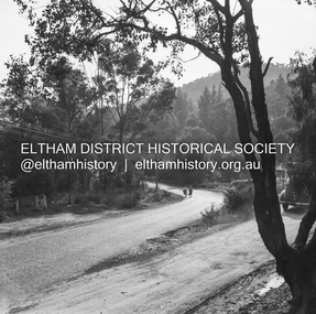
 Eltham District Historical Society Inc
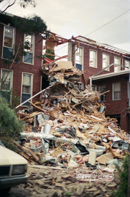
Negative - Photograph, J.A. McDonald, Removal of the remains of the Abraham house at Kangaroo Ground, c. May 1962
Martin Bros House Removing of Seaford was contracted to remove the remains of the storm damaged Abraham house from the property circa May 1962. The Abraham family owned land near the Aqueduct and east of Nicholas Lane at Kangaroo Ground (based on photos, at or near 40 Nicholas Lane).Record of various Shire of Eltham infrastructure works undertaken during the period of 1952-1962 involving bridge and road reconstruction projects, sometimes with Eltham Shire Council Project Reference numbers quoted. It was during this period that a number of significant improvements were made to roads and new bridges constructed within the shire that remain in place as of present day (2022). In many situations, the photos provide a tangible visible record of infrastructure that existed throughout the early days of the Shire. The album was put together by or under the direction of the Shire Engineer, J.A. McDonald.1962-05, abraham house, kangaroo ground, martin bros house removing seaford, nicholas lane, property damage -
 Eltham District Historical Society Inc
Negative - Photograph, Harry Gilham, Demolition of Eltham Shire Offices, 895 Main Road, Eltham, Aug. 1996
The Shire Offices opened in 1965 and were extended in 1971. The final Eltham Shire Council meeting was held in December 1994 before the forced amalgamations of municipal councils by the Kennett Government. The State-Government-appointed Commissioners (1994-1996) took the decision in July 1996 to demolish the Eltham Shire Offices. The demolition works started within 24 hours of the decision being made.Roll of 35mm colour negative film, 5 of 6 strips Associated colour printKodak Gold 100-5eltham shire office, demolition -
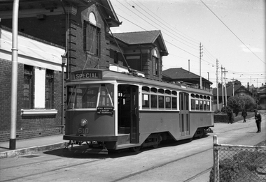
 Melbourne Tram Museum
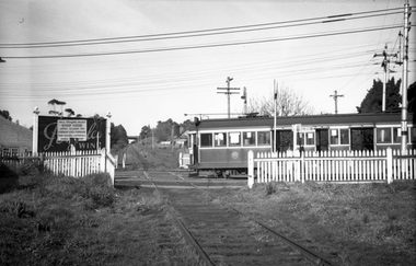
Negative, Wal Jack, 24/07/1944 12:00:00 AM
Black and white negative, by Wal Jack, of W2 365 in Whitehorse Road, crossing the outer circle railway. The tram has the destination of Balwyn. Note the sign on the level crossing requiring all trains to stop before proceeding. In the background is a Penfolds Wine billboard. Photo dated 24-7-1944 in the Wal Jack album along with details of the location and the tramcar.trams, tramways, balwyn, whitehorse road, level crossings, outer circle railway, w2 class, tram 365 -
 Eltham District Historical Society Inc
Negative - Photograph, J.A. McDonald, Heidelberg-Kinglake Road, 11 May 1961
Silvan Road Bridge Looking northwards before reconstruction View centreline to left of old bridge site 11 May 1961Record of various Shire of Eltham infrastructure works undertaken during the period of 1952-1962 involving bridge and road reconstruction projects, sometimes with Eltham Shire Council Project Reference numbers quoted. It was during this period that a number of significant improvements were made to roads and new bridges constructed within the shire that remain in place as of present day (2022). In many situations, the photos provide a tangible visible record of infrastructure that existed throughout the early days of the Shire. The album was put together by or under the direction of the Shire Engineer, J.A. McDonald.1961-05-11, heidelberg-kinglake road, infrastructure, bridge construction, shire of eltham, reconstruction works, road construction, silvan road bridge -
Whittlesea Historical Society Inc.
Archive - Box, Whittlesea Historical Society - WHS - Maps. 1
Archive Box with lid - Whittlesea Historical Society - WHS - Maps. 1. Contents: 1. Green binder Folder, labelled "Maps", with inventory of contents. Contents: 1. Map Parish of Keelbundora, 11 June 1956, large sheet 2. Map Parish of Keelbundora, undated, one sheet 3. Map Parish of Keelbundora, 1946 4. Map Parish of Keelbundora 5. Map Parish of Keelbundora, 5 Jun 1953 6. Map Parish of Keelbundora, blue sheet 7. Morang - Portions 11-14, A4 page 8. Golden Wattle Estate, 23 Feb 1962, A3 sheet 9. Range View Estate, A4 sheet 10. Golden Wattle Ranges Estate, 22 Feb 1962, A4 sheet 11. Golden Wattle Estate Hurstbridge, A3 12. Shire of Whittlesea including Epping Station, Nov 86, A3 13. Whittlesea, including Epping Road, A3 14. Station Estate Thomastown including Thomastown Railway Station 15. Station Estate Thomastown including Thomastown Railway Station 16. Thomastown Estate, date prior to decimal currency, A3 poster 17. Certificate of Title - Thomastown Station subdivision, 18 Oct 1926, Transfer of Lands Act Titles 18. Plan of Subdivison of Stages 1 & 2 Thomastown 19. Poster - Auction Sale Thomastown, 27 Oct 1923 20. Thomastown, 24 Nov 1907. Grey coloured Archive Box containing mapsWhittlesea Historical Society - WHS - Maps. Box 1.map, archive, achival box -
 Eltham District Historical Society Inc
Negative - Photograph, Eltham Shire Council, Unidentified road, Eltham district, c.1985
One of a series of images on roll of film shot by Eltham Shire Council officers focussing on road and street infrastructure maintenance and upgrades and new rollover kerb and channel profilesRoll of 35mm colour negative film, 5 stripsKodak CP100 5094infrastructure, road construction, road drainage, road sealing, roadworks, shire of eltham, streets, streetscape -
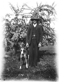 Wodonga & District Historical Society Inc
Negative - Haeusler Glass Negatives Collection - A man and his dog, c1910
The Wodonga Historical Society Haeusler Collection provides invaluable insight into life in late nineteenth and early twentieth century north east Victoria. The collection comprises manuscripts, personal artefacts used by the Haeusler family on their farm in Wodonga, and a set of glass negatives which offer a unique visual snapshot of the domestic and social lives of the Haeusler family and local Wodonga community. The Haeusler family migrated from Prussia (Germany) to South Australia in the 1840s and 1850s, before purchasing 100 acres of Crown Land made available under the Victorian Lands Act 1862 (also known as ‘Duffy’s Land Act’) in 1866 in what is now Wodonga West. The Haeusler family were one of several German families to migrate from South Australia to Wodonga in the 1860s. This digital image was produced from one of the glass negatives that form part of the collection, probably taken by Louis Haeusler (b.1887) with the photographic equipment in the Wodonga Historical Society Haeusler Collection. This item is unique and has well documented provenance and a known owner. It forms part of a significant and representative historical collection which reflects the local history of Wodonga. It contributes to our understanding of domestic and family life in early twentieth century Wodonga, as well as providing interpretative capacity for themes including local history and social history.Digital image created from the Haeusler Glass negative collection. A man and his dog. The man is wearing a three piece suit and a hat. This is typical men's clothing at the beginning of the 20th century. There is a tree in the background. wodonga pioneers, haeusler family, glass negatives, dry plate photography, men's clothing c. 1910 -
Moorabbin Air Museum
Archive (Item) - Box Baa 20 Boeing (Gaf / Asta) Collection
Description: - JINDIVIK DRAWINGS B3B-86-433 TO B3B-86-550 Level of Importance: National. Historical Details: DAP/GAF/ASTA constructed many overseas designs under licence in Australia (Beaufort, Beaufighter, Lincoln, Canberra and F18) however they also designed and constructed a number of significant local designs that were successful in oversea's markets includi -
 Eltham District Historical Society Inc
Negative - Photograph, J.A. McDonald, Sherbourne Road, Montmorency, c. July 1962
View looking west across Sherbourne Road to intersection of Rattray Road from present-day forecourt entrance to 7-Eleven Eltham service station The BP Service Station is now an Ampol Service Station (2022) Google Street View Apr.. 2022 https://goo.gl/maps/LM4APKCwj1ohBDPv5Record of various Shire of Eltham infrastructure works undertaken during the period of 1952-1962 involving bridge and road reconstruction projects, sometimes with Eltham Shire Council Project Reference numbers quoted. It was during this period that a number of significant improvements were made to roads and new bridges constructed within the shire that remain in place as of present day (2022). In many situations, the photos provide a tangible visible record of infrastructure that existed throughout the early days of the Shire. The album was put together by or under the direction of the Shire Engineer, J.A. McDonald.1962-07, ampol service station, bp service station, montmorency, rattray road, service station, sherbourne road, graders, infrastructure, public telephone box (red), reconstruction works, road construction, shire of eltham -
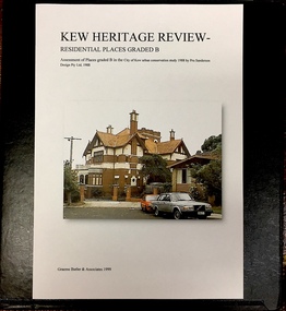 Kew Historical Society Inc
Archive (Sub-series) - Subject File, Kew Heritage Review, Residential Places Graded B, Volume 3, 1999
Graeme Butler & AssociatesProject FilesProvenance OrderBlack 4-Ring binder that includes research about, and an assessment of buildings previously graded B in the City of Kew Urban Conservation Study 1988 by Pru Sanderson Design Pty Ltd. The files were created by the heritage architect Graeme Butler and the paper files include maps, correspondence, title searches, readings, reviews of prior classifications, newspaper and journal articles, directories etc for each property assessed.graeme butler, heritage reviews - kew, 4 cameron court, 2 hodgson street, 20 fellows street, 26 fellows street, 23 highbury grove, kew lunatic asylum, kew mental hospital, willsmere, 36 stawell street, 13 studley avenue, 16 studley avenue, 20 studley avenue, raheen, studley park road, beament house, 33 uvadale road, 20 yarra streetgraeme butler, heritage reviews - kew, 4 cameron court, 2 hodgson street, 20 fellows street, 26 fellows street, 23 highbury grove, kew lunatic asylum, kew mental hospital, willsmere, 36 stawell street, 13 studley avenue, 16 studley avenue, 20 studley avenue, raheen, studley park road, beament house, 33 uvadale road, 20 yarra street -
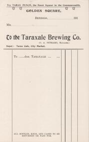 Bendigo Historical Society Inc.
Financial record - PETHARD COLLECTION: TARAXALE BREWING CO. INVOICE
Blank invoice for the Taraxale Brewing Co. Golden Square (G.A. Pethard, Manager). Depot: Tarax café, city Market. try Tarax punch the finest liqueur in the Commonwealth.bendigo, business, taraxale brewing co. -
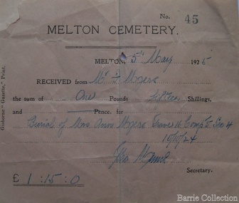 Melton City Libraries
Financial record, Melton Cemetery cheque, 1925
Ann, Henri and their sons Henry and Frederick are buried in the Melton CemeteryFor Ann Myer's buriallocal identities -
Stawell Historical Society Inc
Archive, St Matthews Presbyterian Church Committee 1964 – 1977 Records, 1964 -1977
Various Recordsstawell, religion -
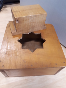 Vision Australia
Education kit - Object, Maths trainer
A hollow wooden box with an 8 pointed hole cut in top. A wooden block fits into the hole. The block is rectangular and one end has a straight bar along one side, the other end has two pointed parts on one side. There are no accompanying instructions.1 square light brown wooden box with block inserted assistive devices, education aids and devices -
 Wodonga & District Historical Society Inc
Negative - Haeusler Glass Negatives Collection - Mick Egan's house being built by Louis Haeusler, c1910
The Wodonga Historical Society Haeusler Collection provides invaluable insight into life in late nineteenth and early twentieth century north east Victoria. The collection comprises manuscripts, personal artefacts used by the Haeusler family on their farm in Wodonga, and a set of glass negatives which offer a unique visual snapshot of the domestic and social lives of the Haeusler family and local Wodonga community. The Haeusler family migrated from Prussia (Germany) to South Australia in the 1840s and 1850s, before purchasing 100 acres of Crown Land made available under the Victorian Lands Act 1862 (also known as ‘Duffy’s Land Act’) in 1866 in what is now Wodonga West. The Haeusler family were one of several German families to migrate from South Australia to Wodonga in the 1860s. This digital image was produced from one of the glass negatives that form part of the collection, probably taken by Louis Haeusler (b.1887) with the photographic equipment in the Wodonga Historical Society Haeusler Collection. This item is unique and has well documented provenance and a known owner. It forms part of a significant and representative historical collection which reflects the local history of Wodonga. It contributes to our understanding of domestic and family life in early twentieth century Wodonga, as well as providing interpretative capacity for themes including local history and social history.Digital image created from the Haeusler Glass negative collection. Image of Louis Haeusler building Mick Egan's house. The house is now under the Hume Weir,wodonga pioneers, haeusler family, glass negatives, dry plate photography, house construction -
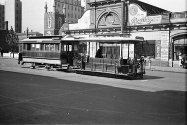
 Melbourne Tram Museum
Negative, Wal Jack, 29/11/1947 12:00:00 AM
Black and white negative, by Wal Jack, of Y1 610 at Camberwell depot while running an AETA Tour, 29-11-1947 - See also Reg Item 5192 and 5159.trams, tramways, camberwell depot, y1 class, aeta tour, tram 610 -
Bendigo Historical Society Inc.
Archive - MCCOLL, RANKIN AND STANISTREET COLLECTION: CENTRAL DEBORAH MINING BOX
Mining Box: metal box, painted dark blue, formerly box number 481 - Now Central Deborah Mining Box 1. Tag affixed to front ' Box 481' Printed on door in white paint ' Central Deborah'. Box contains various documents relating to Central Deborah Mine. Documents are individually catalogued within box.Central Deborah - printed on doormining, parish map, central deborah gold mine, mccoll, rankin and stanistreet, mining, goldmining, central deborah gold mine. -
 Melbourne Tram Museum
Negative, Wal Jack, 1940
Black and white negative, by Wal Jack, of a cable tram set, trailer 568 waiting to enter the terminus at Bourke St, c1940. Tram has the destination of Spencer with the trailer having the side destinations of Northcote and Smith St. Note the lady with an overcoat and suitcase on the right side of the photo. In the background is the Peoples Palace, Hudson's Stores, advertising Alsatian paints, Dockers Revelite paints, tools, Shell products. Also St. Augustine's Parish church and the West Melbourne police station watch house.trams, tramways, cable trams, bourke st, tram 568 -
 Ringwood and District Historical Society
Archive - Parent Record, Football Leagues - Archive Collection (Parent Record)
Parent Record for Archive collection of photographs and documents relating to various Football League -
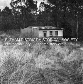 Eltham District Historical Society Inc
Negative - Photograph, J.A. McDonald, Road Reserve Housing, Mar. 1961
Shack built on road reserve without permit Most probably up on Simms Road, Kinglake Other areas where illegal shacks were built wer at the junction of Flat Rock Road and Cherry Tree Road, Hurstbridge. At times, Building Surveyor George E Newton would have to attend to these shacks for inspection and issue demolition ordersRecord of various Shire of Eltham infrastructure works undertaken during the period of 1952-1962 involving bridge and road reconstruction projects, sometimes with Eltham Shire Council Project Reference numbers quoted. It was during this period that a number of significant improvements were made to roads and new bridges constructed within the shire that remain in place as of present day (2022). In many situations, the photos provide a tangible visible record of infrastructure that existed throughout the early days of the Shire. The album was put together by or under the direction of the Shire Engineer, J.A. McDonald.infrastructure, shire of eltham, 1961-03, building surveyor, cherry tree road, flat rock road, george e. newton, houses, hurstbridge, kinglake, road reserve, road reserve housing, scan - 120 format 6x6 negative, shack, simms road -
 Eltham District Historical Society Inc
Negative - Photograph, Russell Yeoman, Shire of Eltham War Memorial, Memorial Park, Garden Hill, Eltham-Yarra Glen Road, Kangaroo Ground, c.1980
Shire of Eltham War Memorial Tower at Kangarooo Ground; view from the east and close up of entrance including Honour Roll. On November 11th 1926 the Shire of Eltham War Memorial Tower at Kangaroo Ground was opened. It is regarded as one of Melbourne’s most outstanding lookout towers. It commands a magnificent 360 degree panorama from Kinglake across the Diamond Valley to Macedon and the You Yangs. It is built on a peak which was once a volcano, 237 metres above sea level. After World War one a memorial cairn was erected on the site, and in 1925 a committee of public-minded citizens began to plan for a tower. Many generous donations of material and money were forthcoming so that in 1926 the Governor General Lord Stonehaven was able to unveil the plaque before a crowd of 500 people There was some concern in the 1960s when the Forests Commission wanted to build a firespotters cabin on the top. At first R.S.L. branches opposed the idea, but it was realised that this use could combine with its use as a tourist attraction, and would ensure its maintenance for the future. Today the Kangaroo Ground tower provides one of the best views around Melbourne and is a fitting memorial to those who died in two world wars. From: Historic items for Diamond Valley Community Radio September 1990 (EDHS collection) On November 8th, 1951, the memorial was re-dedicated by the Governor of Victoria, Sir Dallas Brooks with the addition of the names of men from the Shire of Eltham who fell in the Second World War. Further wreaths were added subsequent to this image in time for the 2001 Reembrance Day service to commemorate the men from th shire who had fallen in the Malayan, Korean, Borneo and Vietnam campaigns.Roll of 35mm colour negative film, 2 strips Kodak Safety 5035 Colour print (x1)Kodak Safety 5035garden hill, kangaroo ground, kangaroo ground memorial, memorial park, shire of eltham war memorial, shire of eltham war memorial tower, war memorial, kangaroo ground relief committee -
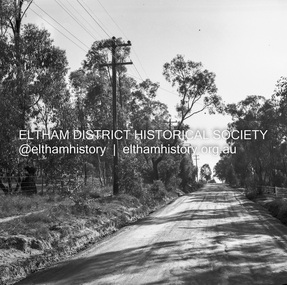
 Eltham District Historical Society Inc
Negative - Photograph, J.A. McDonald, Healesville-Yarra Glen Road, c.1957
Bridge over Long GullyRecord of various Shire of Eltham infrastructure works undertaken during the period of 1952-1962 involving bridge and road reconstruction projects, sometimes with Eltham Shire Council Project Reference numbers quoted. It was during this period that a number of significant improvements were made to roads and new bridges constructed within the shire that remain in place as of present day (2022). In many situations, the photos provide a tangible visible record of infrastructure that existed throughout the early days of the Shire. The album was put together by or under the direction of the Shire Engineer, J.A. McDonald.infrastructure, shire of eltham, bridge construction, healesville-yarra glen road, 1957, long gully, healesville, long gully creek, old healesville road, jackson & dethridge, new zealand insurance co. ltd., public risk claim -
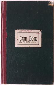
Lakes Entrance Regional Historical Society (operating as Lakes Entrance History Centre & Museum)
Financial record - Ledger, Cash Book, 13625
Entries are hand written in ink, 60 of 84 pages have been used, 20 loose leaf inserts, some pages with pinned inserts, leather bound with heavy cardbaord cover.A cash book containing details of various funds, (Sick and Funeral, Management, Medical, Contingent) for Loyal Cunninghame Lodge of Manchester Unity Independent Order of Oddfellows (MUIOOF).accounts book -
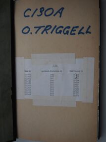 Moorabbin Air Museum
Education kit (item) - C130A General Studies 1964, O.Triggell Course Notes
-
 Warrnambool and District Historical Society Inc.
Financial record - Toc-H Journal, Circa 1936
Ellerslie Hall was established in Warrnambool in 1889, as one of the first private schools of the time. Apart from use as a private college, the hall housed the first classrooms of the Warrnambool High School (then Warrnambool Agricultural High School) for a period in 1907 then went on to be established as the home of the 3rd Warrnambool Scout Troup... in the 1920’s which had associations with the Toc H movement. The hall was also the location of the first Lutheran services in Warrnambool from 1933. In more recent years the property has been used as a residence and for office use. In 2023 the hall is being used by the Sanctuary Church.This journal represents a link to an important International movement, the Toc H movement. One of the founders, Tubby Clayton, visited Warrnambool in 1925 and again in 1952 when he stayed with Sir David Fletcher Jones who considered him one of the greatest spiritual influences in his life. Along with this journal donated by the Swinton family is a collection of photographs of Toc H members. Bottle green card cover with maroon cloth spine. Ninety five pages lined and columned. Handwritten cash book entries for Ellerslie hall accounts and Toc H at the front and journal entries towards the back. There are two loose sheets of paper at the back of the book, one containing a list of names and promised donations and the second, Toc H prayer and principles. Cash Book label on front cover with Journal Fol 75/6 handwritten underneath. On top of label:” Ellerslie Hall A/c. D.F. Jones: W. M. Davies, E. Salamy, H. W Horn, L. G. Mills, trustees. warrnambool, toc h ellerslie hall, david fletcher jones, w m davies, e salamy, h w horn, l g mills. -
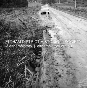
 Eltham District Historical Society Inc
Negative - Photograph, J.A. McDonald, Rattray Road East, Montmorency, 8 May 1961
From south boundary lot looking along proposed alignment 1 May 1961Record of various Shire of Eltham infrastructure works undertaken during the period of 1952-1962 involving bridge and road reconstruction projects, sometimes with Eltham Shire Council Project Reference numbers quoted. It was during this period that a number of significant improvements were made to roads and new bridges constructed within the shire that remain in place as of present day (2022). In many situations, the photos provide a tangible visible record of infrastructure that existed throughout the early days of the Shire. The album was put together by or under the direction of the Shire Engineer, J.A. McDonald.infrastructure, montmorency, rattray road, road construction, shire of eltham, 1961-05-08 -
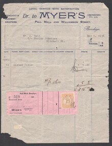 Bendigo Historical Society Inc.
Financial record - Financial record of purchase and payment made by Mr. A. Hall, c/- Morley Johnsons, Mitchell Street, Bendigo; of a carved table dated 1 May 1936
social history of Myer business operations and records.Financial record of purchase and payment made by Mr. A. Hall, c/- Morley Johnsons, Mitchell Street, Bendigo; of a carved table for three pounds fifteen shillings and seven pence (includes ten percent discount); dated 1 May 1936. Includes pink slip wit stamp duty attached. social history -
Bendigo Historical Society Inc.
Archive - MCCOLL, RANKIN AND STANISTREET COLLECTION: NELL GWYNNE REEF - MINING BOX
Mining Box. Metal painted green with Nell Gwynne Reef painted on the lid. Nell Gwynne Reef Box number 486, now Nell Gwynne Reef Box 10mining, mining box, mccoll, ranking & stanistreet