-
 Kew Historical Society Inc
Archive (Series) - Presbyterian Church [East Kew]
Various PartiesReference, Research, InformationArranged by Secondary Values (value of records to users)The Presbyterian Church in East Kew was formed in 1925, with a permanent building constructed by 1939 on Normandy Road. The church, established by Rev. Finlay McQueen was founded to aid those who lived far from the established church in Kew. It underwent extensions that opened in 1960. The file includes: Four copies of a history of the church on its 50th anniversary, and an order of service created to commemorate the opening of the extensions.east kew presbyterian church – kew (vic.), uniting church – kew (vic.), presbyterianism – kew (vic.), finlay mcqueen – kew (vic.)east kew presbyterian church – kew (vic.), uniting church – kew (vic.), presbyterianism – kew (vic.), finlay mcqueen – kew (vic.) -
Glenelg Shire Council Cultural Collection
Plan - Plans - Port of Portland Slipway Fishing vessel 'Marian H.', 16/03/1983
Front: '40' - black texta, top right cornerport of portland -
Kew Historical Society Inc
Archive (series) - Subject File, MCWILLIAM, Gwen
Kew Historical SocietySince its foundation in 1958, members of the Kew Historical Society have been compiling and storing information about subjects relating to the history of Kew and its environs, of which this file is an example. Arranged by Secondary Values (value of records to users)Subject file created by researchers of the Kew Historical Society containing material about Gwen McWilliam, who worked as a foundation member of the Hawthorn Historical Society, wrote histories about Hawthorn (and other parts of Boroondara), and acted as a tour guide in her local area. Included in the file are newspaper articles which recount her fight to retain a garden they cultivated on her nature strip, biographical information and advice about undertaking family history research.gwen mcwilliam, local history -- boroondara, local history reserachgwen mcwilliam, local history -- boroondara, local history reserach -
Whitehorse Historical Society Inc.
Map, Museum extension May 2002, 2002
Plan and elevation of extension to the Museum at Schwerkolt Cottage & Museum Complex May 2002.Plan and elevation of extension to the Museum at Schwerkolt Cottage & Museum Complex May 2002.Plan and elevation of extension to the Museum at Schwerkolt Cottage & Museum Complex May 2002.schwerkolt cottage & museum complex, extension -
Clunes Museum
Negative - NEGATIVES
LEONARD CARTER WAS A PHOTOGRAPHER. HE ORIGINALLY LIVED IN CLUNES AND LATER IN APOLLO BAY. FAMILY HOME WHERE ROBERT CAMPBELL NOW LIVES.1 NEGATIVE OF CARTER FAMILY'S GRAVE HEADSTONElocal history, photography, photographs, negatives, -
University of Melbourne, Burnley Campus Archives
Plan (Item), Gibson North Island Bed 1:50 Nov. '17, 2017 - 2019
-
Glenelg Shire Council Cultural Collection
Plan - Ship Plan / Mould, n.d
Wooden pattern for mould for boat fitting. Arch shaped, flat base. Smaller arch shaped piece attached to front and back. Centre section shaped narrower at top, small wooden cylinder through centre. Traces of white paint. -
 Queenscliffe Maritime Museum
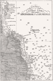
Map - B & W coastal map of Hinchinbrook Island to Cape Melville in Queensland, Coastal map Queensland Hinchinbrook Is to Cape Melville, Before donation in 1987
Australian coastal mapsAustralian coastal mapsMap from unknown book of Queensland coast Hinchinbrook Island to Cape Melville, pre 1987Reverse " NIL "old maps of australian coast -
 Bendigo Historical Society Inc.
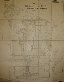
Map - JACK FLYNN COLLECTION: MOLIAGUL, October 1946
Map: Parish of Moliagul, Sheet 1, County of Gladstone. Parish plan.map, gladstone, parish plan, moliagul -
Glenelg Shire Council Cultural Collection
Negative - Negative - Portland Harbour, Victoria, Zilah Maschmedt, c. 1934
Negative for a black and white photograph. Image shows Portland Harbour, looking east. Ocean Pier, Railway Pier. Vessel playing the part of Henty's 'Thistle' at centenary of landing, anchored off Railway Pier, bunting on rigging. -
Ringwood and District Historical Society
Legal record - Conditions of Sale (C.E.Carter), Doncaster, Lot (?) on Plan of Subdivision (?), Mr K.M.Matheson and Mrs L.O.Foster, 1944
Particulars and Conditions of Sale of Property , from Mr K.M.Matheson to Mrs L.O.Foster. -
Ringwood and District Historical Society
Legal record - Conditions of Sale (C.E.Carter), Ringwood - Crown Allotment 27, Harry Peake to ?
Particulars and Conditions of Sale of Property , Harry Peake to ? Dated December 1924. -
Stawell Historical Society Inc
Archive - Book, Stawell Shire, Registration Of Residence Sites 28-7-1931 - 20-6-1934, 1931
Residence Area Miners Right used by Stawell ShireLarge Brown Covered Leather Ledger with Label on front coverStawell Ararat Mining District Registration Book 12P local government, miners right -
 Eltham District Historical Society Inc
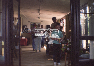
Negative - Photograph, Open Day, Eltham Living and Learning Centre, 7 Nov 1987
Open Day, Eltham Living and Learning Centre, part of the Eltham Community Festival activites, 7 Nov. 1987eltham, eltham festival, eltham living and learning centre, living and learning centre, open day -
Whitehorse Historical Society Inc.
Map, Burwood Road, Box Hill City, 15/02/1952 12:00:00 AM
Detailed map of subdivision along the north side of Burwood Road, Box Hill between Station Street and Middleborough Road.Detailed map of subdivision along the north side of Burwood Road, Box Hill between Station Street and Middleborough Road. Shows many block owners, types of buildings, nature of fencing. Marked as 'Survey Plan No 5440'.Detailed map of subdivision along the north side of Burwood Road, Box Hill between Station Street and Middleborough Road. maps, burwood road, burwood, andrews street, greenwood street, tennyson street, middleborough road, station street -
Port Melbourne Historical & Preservation Society
Plan - Edwards Park improvements (Trugo Green), Port Melbourne, 1950s
Plan drawing to scale, hand coloured, of proposed improvements to Edwards Park (Trugo Green), possibly early 1950s."City of Port Melbourne"built environment - recreational facilities, parks and gardens, sport - trugo, port melbourne trugo club -
 Eltham District Historical Society Inc
Negative - Photograph, J.A. McDonald, Heidelberg-Kinglake Road, Sep. 1959
Job 56M Contractor Hillgrove Ironbark Gully bridge looking south September 1959Record of various Shire of Eltham infrastructure works undertaken during the period of 1952-1962 involving bridge and road reconstruction projects, sometimes with Eltham Shire Council Project Reference numbers quoted. It was during this period that a number of significant improvements were made to roads and new bridges constructed within the shire that remain in place as of present day (2022). In many situations, the photos provide a tangible visible record of infrastructure that existed throughout the early days of the Shire. The album was put together by or under the direction of the Shire Engineer, J.A. McDonald.infrastructure, shire of eltham, bridge construction, 1959-09, heidelberg-kinglake road -
 Mission to Seafarers Victoria
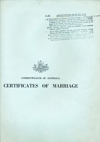
legal record (item) - Register Receipts, Circa 1982
The receipts are dated from the 20th of November 1982 to the 8th of July 1989. The last receipt has been crossed out, possibly cancelled. The is a handwritten note within the register. They document some of the information needed on the actual marriage certificate, such as the date and location, bride, bridegroom and celebrant's names, as well as the date the each certificate was sent to registering authority.Part of the record of weddings performed at the Mission to Seafarers between 1982 to 1989.Stamped in black ink on the front cover: N.B INSTRUCTIONS RE: USE OF THIS BOOK (underlined), followed by the instructions. Under this is printed the Australian crest. Under this is printed : COMMONWEALTH OF AUSTRALIA / CERTIFICATES OF MARRIAGE.marriage, wedding, register, receipt, 1982-1989, mission-to-seafarers, port-melbourne, marriages, dio-marriages, st peter chapel, st andrew chapel -
Port Melbourne Historical & Preservation Society
Plan - Proposed Bayside development, Sep 1987
SCDC plans for the Bayside development were revised as investigations into water circulation in artifical canals/harbour were completed. This is the altered plan, with alterations drawn in red on the original proposal, for the EES hearing in September 1987. The EES hearing, scheduled for three days in September, ran for 57 sessions into February 1988.Large plan of original proposed Bayside development as submitted to council in 1987; as 502.01 but with alterations superimposed in red, It was this altered plan that was submitted at the enquiry into the Environmental Effects Statement in September.In blue: EES Variation September 1987:In red: markings to indicate alterations to land configurationtown planning - proposals shelved - bayside, sandridge city development co pty ltd, scdc -
 University of Melbourne, Burnley Campus Archives
Plan, Burnley Gardens. City of Richmond. Parish of Jika Jika - County of Bourke, 1927
Part-coloured plan showing drainage, sewerage drains, taps and waterstops. Area bounded by Swan St. To N, Yarra River on E and Richmond Park on SW side. Contour lines of orchard depicted, laying pens and yards. Coloured area depicts pavilion with surrounding garden and paths layout pencilled in. Photo-Lithograph by Dept. of Lands & Survey, Melbourne by W. Butsonsewerage, drainage, lithograph, pavilion -
Stawell Historical Society Inc
Archive - Book, Stawell Shire, Registration Of Residence Sites 20-8-1900 - 22-9-1904, 1900
Residence Area Miners Right Mining used by Stawell ShireVery Large Burgandy Leather Ledger with marbling on inside cover. Red Spine and Corners IndexedRegister of Residence Area Book 6Plocal government, miners right -
Kew Historical Society Inc
Archive (collection) - Irena Higgins : Fol.24 Disability & Mental Health, 1951-2008
Irena Higgins (1951-2014) > Barbara Higgins (2015) > Kew Historical Society (2015)Professional papersCollection > Series > Sub-series (folder) > ItemGeneral social work – Role of the psychiatric social worker | Social work practices | Social work and social action | Meeting of Departmental social workers working in the field of intellectual handicap | Submission for domiciliary services | White House Conference on children and youth (1960) | Talks | Role of the social worker in Institution for intellectually handicapped children (1953) | Conferences | Job description | Social workers and bureaucracy | Community organisation of social planning | Social work school planning in Illinois | Visits of observation – writing reports | Psychotherapeutic drugs – a guide for social workers | Visiting services – social work | General social work items | [AASW + notes (handwritten)]department of health (vic.), mental hygiene authority (vic.), mental health authority (vic.), health commission of victoria, community services victoria, department of health and community services, department of human services, kew cottages, kew children’s cottages, kew training centre, kew residential servicesdepartment of health (vic.), mental hygiene authority (vic.), mental health authority (vic.), health commission of victoria, community services victoria, department of health and community services, department of human services, kew cottages, kew children’s cottages, kew training centre, kew residential services -
Moorabbin Air Museum
Archive (Item) - Box Baa 41 Boeing (Gaf / Asta) Collection
Description: - JINDIVIK DRAWINGS B4A-A81-028 TO B4A-A81-129 Level of Importance: National. Historical Details: DAP/GAF/ASTA constructed many overseas designs under licence in Australia (Beaufort, Beaufighter, Lincoln, Canberra and F18) however they also designed and constructed a number of significant local designs that were successful in oversea's markets includi -
Kew Historical Society Inc
Archive (Sub-series) - Subject File, Carnsworth (Cameron Court), 1958
Various partiesReference, Research, InformationSecondary Values (KHS Imposed Order)Subject file relating to the house Carnsworth (later renamed Slomcek House) built for Jabez Louis CARNEGIE in 1907-8. In the file, a National Trust (Victoria) citation identifies its date of construction, the original extent of the landholding and style of the house, and comparative examples. The Trust registered the house in 1991. carnsworth - stawell street - kew (vic), jabez lewis carnegiecarnsworth - stawell street - kew (vic), jabez lewis carnegie -
 Kew Historical Society Inc
Plan, Melbourne & Metropolitan Board of Works : Borough of Kew : Detail Plan No.1590, 1905
The Melbourne and Metropolitan Board of Works (MMBW) plans were produced from the 1890s to the 1950s. They were crucial to the design and development of Melbourne's sewerage and drainage system. The plans, at a scale of 40 feet to 1 inch (1:480), provide a detailed historical record of Melbourne streetscapes and environmental features. Each plan covers one or two street blocks (roughly six streets), showing details of buildings, including garden layouts and ownership boundaries, and features such as laneways, drains, bridges, parks, municipal boundaries and other prominent landmarks as they existed at the time each plan was produced. (Source: State Library of Victoria)This plan forms part of a large group of MMBW plans and maps that was donated to the Society by the Mr Poulter, City Engineer of the City of Kew in 1989. Within this collection, thirty-five hand-coloured plans, backed with linen, are of statewide significance as they include annotations that provide details of construction materials used in buildings in the first decade of the 20th century as well as additional information about land ownership and usage. The copies in the Public Record Office Victoria and the State Library of Victoria are monochrome versions which do not denote building materials so that the maps in this collection are invaluable and unique tools for researchers and heritage consultants. A number of the plans are not held in the collection of the State Library of Victoria so they have the additional attribute of rarity.Original survey plan, issued by the MMBW to a contractor with responsibility for constructing sewers in the area identified on the plan within the Borough of Kew. The plan was at some stage hand-coloured, possibly by the contractor, but more likely by officers working in the Engineering Department of the Borough and later Town, then City of Kew. The hand-coloured sections of buildings on the plan were used to denote masonry or brick constructions (pink), weatherboard constructions (yellow), and public buildings (grey). Surveyed by the Board of Works in 1903 and published in 1904, Plan No.1590 shows development north of Cotham Road. While this plan includes built structures in Mary Street, Cotham Road, High Street, Park Hill Road, Kent Street, Ridgeway Avenue, and Ermington Lane (now Ermington Place), only part of this section was notated and coloured in this contractor’s copy. Numerous houses, large and small are named on the plan: ‘Cholula’, ‘Belper’, ‘The Uplands’, ‘Spring Grove’ facing Cotham Road; ‘Marion’ facing Kent Street; and ‘Kia Ora’ facing Ridgeway Avenue.melbourne and metropolitan board of works, detail plans, mmbw 1590, survey plans - borough of kew, cartography -
 Eltham District Historical Society Inc
Negative - Photograph, Frontspiece - "Pioneers and Painters", 1971
Reproduced Page 1 of Pioneers & Painters, edited by Alan Marshall (1971)This photo forms part of a collection of photographs gathered by the Shire of Eltham for their centenary project book,"Pioneers and Painters: 100 years of the Shire of Eltham" by Alan Marshall (1971). The collection of over 500 images is held in partnership between Eltham District Historical Society and Yarra Plenty Regional Library (Eltham Library) and is now formally known as the 'The Shire of Eltham Pioneers Photograph Collection.' It is significant in being the first community sourced collection representing the places and people of the Shire's first one hundred years.4 x 5 inch B&W Neg Black and White prints 20 x 25 (2) and 17.5 x 18.5 cmpioneers and painters, sepp, shire of eltham pioneers photograph collection -
 National Wool Museum
Archive - Advertisement, Onkaparinga Woollen Mill Company, 1964
Note from collector- "For more than 100 years blankets were made all over Australia in over 100 woollen mills. My aim, is to preserve 100 examples of these wonderful pieces of history. Ten years ago I started collecting the iconic Onkaparinga travel rugs, so that on movie nights at home there would be plenty to go around. Everyone had their favourite; even the cat had his own – a small red tartan one. Keeping an eye out for those travel rugs at op-shops and markets, collectable stores and bazaars, led to noticing vintage blankets. I'd never really thought about them before or paid much attention though of course I had grown up with them at my grandmother's. When I discovered my first Laconia cream blanket with blue stripes, my eyes just went gaga. Well that was it, I was hooked and since then over 500 blankets have passed through my hands. These common, everyday items, found in all households for so many decades, were traditional engagement gifts. Pairs were prized wedding presents turning into family heirlooms. They were fashionable dressers of beds, givers of warmth, bestowers of security and reliability. The comfort found in these objects resonates with almost all of us; we grew up with them ourselves or fondly recall them in a grandparent’s home. There is no modern replacement with the integrity of these old blankets, many of them now older than most of us. They are romantic, sensible, special, familiar, nostalgic and nothing else feels so appropriate in so many situations. No offense to the great Aussie doona, but from hippie to hipster, at a music festival, picnic, campsite or couch, a vintage blanket is something coveted by all. This industry that employed tens of thousands and must have been such a huge contributor to the economy is almost completely lost now. Blanket Fever is an ode to everything that came before: the land, the sheep, the shearers, the hands, the mills, the weavers, the designers, the distributors, the department stores. To the grandparents that gave them, the people that received them, the families that kept them; thank you. I’m passionate about my collection of Australian blankets manufactured in mostly Victoria, South Australia and Tasmania from the 1930s to the end of the 1960s. The collection has blankets from each of these four decades representing the styles and fashions of their time and includes dated advertisements which help determine the eras the blankets are from." There's no question about the brand, only the colour (blanket range) There's no question about the brand….only the colour!/Onkaparingablanket, blanket fever, onkaparinga, wool, advertisement, australian women's weekly -
 Mission to Seafarers Victoria
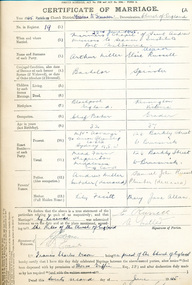
legal record (item) - Register, Register II Missions to Seamen Port Melbourne, Circa 1945
The register documents twenty-one weddings that took place in the Mission to Seamen's church district between the 22nd of June, 1945 to the 1st of December 1962. Each certificate is a record of all the information needed to legalise a marriage under Commonwealth law, such as names, dates of birth, marital status, parents and employment. Within the register, there are two letters confirming that grooms are bachelors, and one Statutory Declaration signed by a bride, declaring she is a spinster.The register is a historical record of weddings performed at the Mission to Seamen church between 1945 to 1962.Handwritten in black ink on the front cover: REGISTER NO II (underlined) / MISSION TO SEAMEN / PORT MELBOURNE / NO 19 - / 22-6-45 - / (REGISTER NO 1. / 6-4-29 - 19-3-42 IS KEPT AT / CENTRAL).marriage, wedding, 1945-1962, register, marriages, dio-marriages, mission to seafarers, seamen's mission -
 Melbourne Tram Museum
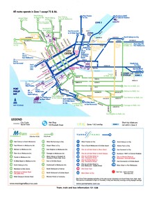
Map, VicTrip, Melbourne tram network - Yarra and M>Tram, 2000
Map - Colour print - of Melbourne's tram network, shows the lines operated by M>Tram or Yarra Trams, route numbers, ticket zones, zone overlaps and contact websites. - used in Fares and Travel Guide - 2000 and 2001 Map - see Reg Item 2508.trams, tramways, connex, map, melbourne, tramways, m>tram, yarra trams -
University of Melbourne, Burnley Campus Archives
Plan, Merri Creek Management Committee, c. 1990
(1) 2 sets Base Maps Scale 1:5000 MCMC. (2.) 2 sets Merri Creek remnant vegetation Scale 1:5000.merri creek, management plan