-
 Melbourne Tram Museum
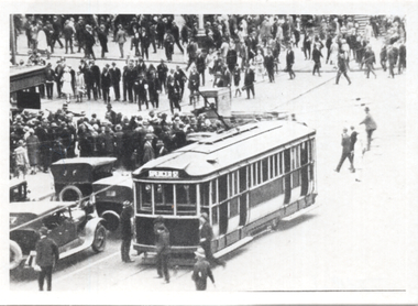
Photograph - Black & White, G class tram - Flinders St station, mid to late 1920s
The photographs show a G glass tram westbound in Swanston St with a W class tram northbound during the mid to late 1920s. Enlarged from a postcard - see item 5883.Yields information about a G class tram and other trams at Flinders St station.Set of 2 Black and White photographs of a scene at Flinders St station with the G class tram enlarged.Has ink notes on rear regarding the location and the TMSV sales stamp.tramways, trams, g class, flinders st, swanston st, flinders st station, w class -
 University of Melbourne, Burnley Campus Archives
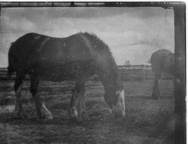
Photograph - Black and white print, Stallion, 1917
Not BurnleyBlack and white photograph cut out of a small strip of prints. A stallion with part of another horse next to it.On reverse, "Stallion Werribee Research Farm Oct 1917."stallion, werribee, research farm, 1917, horse -
 Glen Eira Historical Society
Photograph, Dalny Road, 5-17 Rear, Murrumbeena, 2001
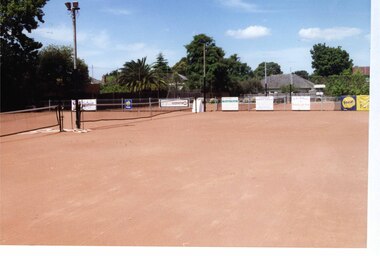
Originally labelled "Beauville Estate, Established 1936, Still Thriving 65 years on, 10th March 2001", the Beauville Estate Album contains colour photographs of houses in the Estate. They were taken around the time of the Beauville Estate’s 65th Heritage Celebration held on 10/03/2001 and donated to the Caulfield Historical Society shortly afterwards. Photographer unknown. From Glen Eira’s Heritage Management Plan by Andrew Ward (1996) Vol 2 p78: "Beauville Avenue is unusual in that it is terminated in a cul-de-sac (see Section 3.9.2) whilst the design of the estate may well be unique for its time in that the houses back onto 6 tennis courts for public use. St. Patrick's Church, which adjoins the estate is a comparatively recent structure whilst the school has one building erected in 1930 and prior to the release of the Beauville lots." It also notes that St.Patrick's Church and School now run the tennis courts. City of Glen Eira’s Heritage Management Plan Vol 2 p79 (this is p84 of the pdf version) – HO12 Beauville Estate and environs, Murrumbeena: The Beauville Historic Area is important at the State level as the first large housing estate undertaken by the AV Jennings Construction Co, later Jennings Group Limited, Victoria’s largest home builder. It is important also as a very early estate development incorporating a range of features other than houses and including made roads, shops and recreation facilities. In this respect it was the forerunner of the comprehensively planned housing estate of the post war era. The estate is distinguished by its aesthetic values, as is the earlier and comparable Hillcrest Estate, which are formed by a combination of restrained diversity in house styles, with the exception of no. 30 in the emerging International style, and by a landscaped garden environment. Colour photograph of tennis courts with lights on the Beauville Estate. murrumbeena, houses, 1930's, a.v. jennings, av jennings, jennings, beauville estate, parks and reserves, sports and recreations establishments, tennis courts, sportsgrounds, sir albert victor jennings, a v jennings construction co, beauville estate heritage area, glen eira city council, architectural features, jennings group limited, land subdivision, gardens, beauville historic area, tennis clubs, beauville tennis courts, st patrick's tennis club, dalny road -
 Bendigo Historical Society Inc.
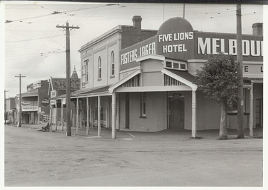
Photograph - FIVE LIONS HOTEL: BENDIGO, 1950/60's
Black and white photograph. Not mounted. Five Lions Hotel,Cnr View and Barnard Streets, Bendigo. Tram lines with overhead cables. 2 men on seat on left of photo. Fosters Lager sign on left with Five Lions Hotel over corner. 2 double storey shops, one next to hotel appears empty, faint name of business ??/ pastrycook. On back ' Five Lions Hotel, cnr. Barnard and View Sts. 'Alan Doney ??organization, business, five lions hotel -
 Melbourne Legacy
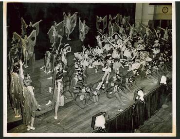
Photograph, Annual Demonstration 1948, 1948
Black and white photo of girls in costumes on stage during an Annual Demonstration. Some of them appear to be butterflies. The photo is very similar to one published in the newsletter as the demonstration in 1948. The album it was in is a collection of press photos taken during dress rehearsals from around that time. Throughout the year Melbourne Legacy provided classes for Junior Legatees such as dancing, gymnastics and Eurythmics. The Demonstration was an annual event to showcase their skills. Melbourne Legacy conducted Annual Demonstrations / Parades from 1928 through to the 1980's, usually held at Melbourne Town Hall. The beautiful costumes were made by members of the Junior Legacy Mothers' Club and the Melbourne Legacy Wives' Association.A record of the displays at the Annual Demonstrations. Also that Legacy provided classes for junior legatees and the skills learned were displayed in the Annual Demonstration.Black and white photo in an album of dancers in butterfly outfits and other costumes on stage.junior legatees, demonstration, annual demonstration, girls classes, costumes -
 Eltham District Historical Society Inc
Photograph - Aerial Photograph, Landata, Eltham; Crown Allotment 15, Section 5, Parish of Nillumbik (Stokes Orchard Estate), Apr. 1978
Centred on present day Diosma Rd, Stokes Pl, Nyora Rd and Eucalyptus Rd Historic Aerial Imagery Source: Landata.vic.gov.au Aerial Photo Details: Project No :1368 Project : DIAMOND CREEK Run : 5 Frame : 71 Date : 03/1975 Film Type : B/W Camera : RC8 Flying Height : 2200 Scale : 4000 Film Number : 3279 GDA2020 : 37°42'50"S, 145°09'36"E MGA2020 : 337821, 5824325 (55) Melways : 22 B5 (ed. 42) A History of the Development of Crown Allotment 15, Section 5, Parish of Nillumbik – Stokes Orchard Crown Allotment 15, Section 5, Parish of Nillumbik (CA15) is a square allotment of 158 acres or approximately a quarter of a square mile. It lies just beyond the eastern end of Pitt Street, south of Nyora Road to the northern end of Eucalyptus Road and extends east from Eucalyptus Road to Reynolds Road. The topography of CA15 is generally steep, sloping up to a hill near the centre of the land, the ridgeline passing through the properties along the southern side of Diosma Road. Eucalyptus Road is a straight north-south road with its northern end at the north west corner of CA15. Until the end of the 1970s this road was an un-named Government Road and was largely not open to traffic. With residential development in the 1970s the road was constructed, and the council allocated the name obviously in recognition of the predominant species of the local bushland. CA15 was purchased from the Crown by George D’Arley Boursiquot, a prominent Melbourne printer, on 28th October 1852. On November 23, 1922, former Member for Gippsland and Melbourne Real Estate Agent, Hubert Patrick Keogh purchased the allotment then sold it March 13, 1925, to local farmer, Robert David Taylor, a former Shire of Eltham Councillor (1911-1920) and Shire President (1919). Taylor had extensive land holdings stretching west towards Bible Street and Main Road. The Taylor home was situated at the top of the hill in Bible Street at present day 82 Bible Street. At the time of Taylor’s purchase in 1925, CA15 was subdivided into 48 lots that could be described as small rural properties or large residential lots. A typical lot size was one hectare or 2.5 acres. The subdivision created two roads, Nyora Road, and Diosma Road, each following an irregular alignment between Eucalyptus and Reynolds Roads. However, the lots were not sold off separately nor were the roads constructed. The land effectively remained as one parcel for many further years. Robert David Taylor died November 30, 1934, and probate was granted to his son of the same name, Robert David Taylor of Bible Street, Salesman and William McLelland Vance Taylor of 73 Emmeline Street, Northcote, Clerk, with the transfer of the land into their names on July 8, 1935. Frank Stokes worked as a qualified accountant at Kennons leather factory in Burnley, while living at 1 Thomas Street, Mitcham. He suffered from migraines and wanted to return to working the land (he had previously worked on farms and orchards since coming to Australia from England in 1926, both in WA and Vic.). He first travelled to the district by train in July 1942 to find land with the intention to establish an orchard. By chance he met Arthur Bird of Bird Orchard (bounded by Pitt Street, Eucalyptus Road, and Wattle Grove) and they got talking over their common interest. Arthur put Frank up for the night and pointed out the land, 158 acres- part of the Taylor Estate- £900, Crown Allotment 15, Section 5, Parish of Nillumbik (CA15) somewhat diagonally opposite Bird Orchard. Stokes applied through the Riverina Agency to purchase the land who in turn applied for permission from Canberra to sell as there was a new government regulation introduced during the Second World War banning land sales except for immediate production. Stokes obtained a loan on his Mitcham house of £600 @ 5% and paid £450 deposit with quarterly payments of £15 spread over 5 years. Stokes was assisted and advised by Arthur Bird who farmed the neighbouring orchard. In early 1943 Stokes took possession and would catch the train out to Eltham on Fridays after work and began building a hut on the corner of Nyora Road and the Government Road (Eucalyptus Road) for shelter and to lock up tools. He established an orchard on the central western part of the land through the centre of which ran a natural waterway (part of the present-day linear park) and was able to pay a neighbour (Hawkins) to help with clearing and fencing 25 acres, and with a horse and single furrowed plough, planted approximately 2,500 fruit trees - cherries, peaches, plums, almonds, pears, apricots and lemons as well as a few apples and oranges; a massive task. Aerial photographs from the 1940s through to the 1990s clearly show the orchard with most of the larger CA15 site remaining as natural bushland. A huge problem was hares and rabbits eating all the new buds off the tiny trees. As well as laying poison he painted the trees with a mixture of cow manure and lime, often working by moonlight. Procurement of wire and wire netting was difficult because of the war but after much effort he obtained a permit from the Agricultural Department for supplies in March 1944. In February 1945 Stokes applied for a permit to build a “packing shed” as no house building was allowed. It was to be 33 feet x 21 feet and cost £312. It was constructed mostly from second-hand materials, which were hard to obtain, especially iron for roofing. Stokes finished work at Kennons on October 31, 1945, and in March 1946 he sold the family home at Mitcham for £1,230 plus £170 for furniture. On May 15, 1946, title to the CA15 property was issued to Frank Howard Alfred Stokes, Orchardist and Gladys Ethel Stokes, Married Woman, both of Pitt Street, Eltham. The family of five then moved into the very unfinished “packing shed” at Eltham, which was a struggle to weatherproof. Eventually rooms were divided off and lined with hessian bags and whitewashed. Their income was firewood (cut and sold), selling rockery stones and cut Sweet Bursaria. (It was discovered during the 1940s that Sweet Bursaria contained the sunscreen compound Aesculin. The RAAF utilised this compound from Sweet Bursaria during WW2 for pilots and gunners.) The orchard’s first fruit sale was a half-case of Le Vanq peaches in December 1947 for the price of 8 shillings. In 1956 plans for house were drawn and Glen Iris bricks purchased (1956 Olympic Rings variant). The building of the house commenced in 1957 - 12 feet of original packing shed was removed – and was completed in 1959. Water was connected from newly built pressure storage on the property at the end of 1959 and the electricity connection for the first time at 3pm on April 29, 1960. The house remains to present day (somewhat modified) at 1 Nyora Road, home to Nyora Studio Gallery. On occasions, spare remnants of the 1956 bricks have been known to be unearthed in gardens on the estate as they were utilised by Frank Stokes to fill in rabbit holes. On May 26, 1950, a parcel of land was compulsorily acquired by the Melbourne and Metropolitan Board of Works on the hilltop to establish an easement for a high-level service reservoir to augment Eltham’s water supply. The project also included pipe tracks for the necessary water mains. The reservoir has now been superseded by higher level water tanks east of Reynolds Road and its former site is now a public reserve. On November 27, 1964, the State Electricity Commission served notice to compulsorily acquire a further parcel through the eastern part of the land for a major electricity transmission line that augmented supply from the La Trobe Valley to Melbourne. The easement was registered February 11, 1966. The easement was widened July 18, 1969 for a second transmission line to be constructed. In 1971 Melbourne Metropolitan Planning Scheme amendments adopted Nyora Road as the boundary between a residential zone to the north and a rural zone to the south. This determined the future development of the land. In the mid-1970s the Shire of Eltham divided the orchard into numerous rate-able parcel lots, the 48 lots having been established in 1925 and the subsequent rates assessment proved unsustainable for Stokes. He commenced selling lots outside the boundary of the orchard, north of Diosma and South of Nyora. However shortly later the land between Nyora and Diosma Roads and west of the electricity easement was sold and subdivided into residential lots, a housing development by Macquarie Builders and marketed as the Stokes Orchard Estate. New streets were created, and most were named after trees, although one, Stokes Place, commemorates the former owners. The development was undertaken in two stages; Stage 1 (1975) encompassing Scarlet Ash Court, Ironbark Close and Peppermint Grove bounded by Nyora and Eucalyptus roads and Stage 2 (1978) encompassing Stokes Place, Orchard Way, The Crest and The Lookout bound by Nyora and Diosma roads. The developer, Macquarie Builders went bankrupt shortly after the release of Stage 2 leaving many purchasers to fend for themselves and arrange for their own independent builders. There were also difficulties with sewerage for the land immediately south of Diosma Road and so the conventional residential lots were abandoned in favour of larger lots. The development of Orchard Way, The Crest and The Lookout did not proceed as planned and the proposed lots were incorporated into five-acre parcels instead. These included a low-density group housing development by the Graves family and the award winning Choong House (1983) with Gordon Ford developed garden immediately next door situated on the ridge of the hill nestled amongst the original bush, Eucalypt trees and Sweet Bursaria. In 1994, Nillumbik Shire Council applied Significant Environment and Significant Landscape overlays upon the properties on the south side of Diosma Road to ensure protection of this natural bush garden environment. With the arrival of the sewer along Diosma Road in the 1990s, most of these five-acre parcels have since been subdivided multiple times. The Choong house presently sits on a 2.7-acre property, which in 2022 Nillumbik Council nominated for Cultural Significance Heritage protection and is considered potentially significant at State level. The Stokes family were also associated with the Eltham Christian Church. In the 1970s this church had met in temporary premises in Eltham. Lots of the original 1925 subdivision remained south of Nyora Road and a number of these lots were utilized for the Eltham Christian School, which was established by the Eltham Christian Church in 1981. The school operated on this site until 2000. The premises are now used by The Vine Baptist Church. By the mid-1980s the whole of CA15 had been developed for residential and school purposes, except for the sections north of Diosma Road and between the transmission lines and Reynolds Road. Sewerage issues had been resolved for the section north of Diosma Road and in 1987 it was in the process of being subdivided into residential lots. The development coincided with the discovery of colonies of the rare and endangered Eltham Copper Butterfly on the site. This resulted in a community and political campaign to save the butterfly habitat. With the co-operation of the land developer the subdivision was altered to create two bushland reserves in the critical butterfly habitat areas. In the late 1980s the State Government was investigating options for establishing a metropolitan ring road link between Diamond Creek and Ringwood. The chosen route was adjacent to Reynolds Road and so this created a freeze on development of CA15 between Reynolds Road and the electricity easement. The ring road proposal was eventually abandoned, and this part of the land was subdivided into low density residential lots. Diosma Road has been discontinued at the electricity easement and the eastern part incorporated into View Mount Court with access from Reynolds Road. The whole of CA15 has now been developed for residential or associated purposes, ranging from conventional density to quite low density south of Nyora Road. Some remnants of the orchard remain, a few cherry trees on the Graves property and a lone apple tree in Stokes Place. The butterfly reserves comprise significant areas of remnant bushland. Linear reserves through the estate link with central Eltham via the Woodridge linear reserve and with Research along the electricity easement. CA15 as it exists today has a complicated history of rural use, Government acquisition, urban development, and community action. References: • “Stokes Orchard, an incomplete history”; Russell Yeoman with Doug Orford • Correspondence, Beryl Bradbury (nee Stokes) • Aerial Photographs, 1931-1991, Landata (landata.vic.gov.au) • Certificate of Title, Vol. 4930 Fol. 985900 • Plan Number LP 10859 aerial photo, diosma road, eltham copper butterfly, eucalyptus road, ironbark close, nyora road, peppermint grove, peter & elizabeth pidgeon collection, power transmission lines, reynolds road, scarlet ash court, stokes orchard estate, stokes place, woodridge estate, frank stokes -
 Lakes Entrance Regional Historical Society (operating as Lakes Entrance History Centre & Museum)
Photograph, Lakes Post Newspaper, 1993
see page 17 Lakes Post Newspaper 7 April 1994Black and white photograph Lions Club members Jack Donnelly Don Jobe Bill Jenkins Peter Spark and Graeme Green cooking team for Lions Fish Tasting. Lakes Entrance Victoriacommunity services, volunteering, lions club -
 Port Melbourne Historical & Preservation Society
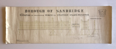
Plan, Charles Clay, Borough Surveyor, Elevation of Proposed Fence to Station Place Reserve, c. 1881
Although undated, the plan is probably from 1880-81. The plan is signed by Charles CLAY, Fred WILLIAMS and Witney Henry BATES. Charles CLAY was the Borough Surveyor from 1860 to 1884. Fred WILLIAMS was a Councillor 1875 to 1886 and served as Mayor, 1880-81. It is not known who Witney Henry BATES was. A note in pencil, probably added later, indicates the fence was between Graham and Bridge Streets.Undated Borough of Sandridge hand-drawn plan for a proposed picket fence at Station Place Reserve.'between Graham and Bridge Streets' handwritten in pencil below and to the right of the main title.local government - borough of sandridge, engineering - fences, charles clay, witney henry bates, frederick williams -
Moorabbin Air Museum
Manual (Item) - HS748 Series II Airframe Course Notes TP-65 Vol 2
-
 Tatura Irrigation & Wartime Camps Museum
Photograph, Camp 1A Sudeten Germans
Camp 1A Sudeten Germans. Back (left to right): 2018 S Weber, 1031 H Bittner; 5001 Iser; 2120 Kobsa; 35134 J Friedrich. Front: 532 Moisel; 4012 Ferd Weber; 155 Goener; 3018 C W Hoffmann; 35236 Schumann.Sepia photograph of a group of 10 men (5 standing, 5 seated) with trees and shrubs behind. 109 centre fronts weber, h bittner, iser, kobsa, j friedrich, moisel, ferd weber, goener, c w hoffmann, schumann, sudeten germans -
 Halls Gap & Grampians Historical Society
Photograph - B/W
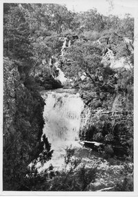
This is a photo of Broken and Drummond Falls. It is part of promotional material for tourism, and was produced by Victorian Railways.The photo shows a series of cascades leading down to a wider set of falls, all surrounded by bush.'Copyright Photograph. This photograph may be reproduced on condition that it is acknowledged as "Victorian Railways Photograph".' stamped on back. "P. 3500" written on back in pencil. "Broken & Drummond Falls" written on back in blue ink.scenery, waterfalls -
Kew Historical Society Inc
Journal, Kewriosity : October 1990
Looking locally for leisure / p1. Your junk Rotary's jewels / p1. Dates for October / p2. Dates to remember / p2. October fetes / p2. Take tea in a monastery garden / p2. Commentary / Cr Daryl Oldaker p3. Road closure [Kew Boulevard] / p3. Hard rubbish collection to start / p3. Notices / p4. Rec Centre seeks info from older adults [Kew Recreation Centre] / p4. Council calls for submissions on skateboard / p4. Kids in Space [musical] / p4. Library corner / p4. Recycling trial / p5. The Play's the Thing [Track Players] / p5. St George's to meet aged care needs / p5. Kew Community House / p6. Kew Info Youth / p6. Hawthorn History / p6. [Kew Primary] School celebrates with song and dance / p6. Connecting community with disability / p7. Bold as brass [Kew Band, Kew Youth Band] / p7.Community clean up / p7. Jelly bean drama / p7. [Kew] Bowling Club honours modern bowls inventor [Ray Hensell] / p8. Hawthorn Centre open day / p8. Letters to the editor / p8. Community leisure / p8. 'The Boyfriend' [Phoenix Music Club] / p8.Kewriosity was a local newsletter combining Kew Council and community news. It was published between November 1983 and June 1994, replacing an earlier Kewriosity [broad] Sheet (1979-84). In producing Kewriosity, Council aimed to provide a range of interesting and informative articles covering its deliberations and decision making, together with items of general interest and importance to the Kew community and information not generally available through daily media outlets.non-fictionLooking locally for leisure / p1. Your junk Rotary's jewels / p1. Dates for October / p2. Dates to remember / p2. October fetes / p2. Take tea in a monastery garden / p2. Commentary / Cr Daryl Oldaker p3. Road closure [Kew Boulevard] / p3. Hard rubbish collection to start / p3. Notices / p4. Rec Centre seeks info from older adults [Kew Recreation Centre] / p4. Council calls for submissions on skateboard / p4. Kids in Space [musical] / p4. Library corner / p4. Recycling trial / p5. The Play's the Thing [Track Players] / p5. St George's to meet aged care needs / p5. Kew Community House / p6. Kew Info Youth / p6. Hawthorn History / p6. [Kew Primary] School celebrates with song and dance / p6. Connecting community with disability / p7. Bold as brass [Kew Band, Kew Youth Band] / p7.Community clean up / p7. Jelly bean drama / p7. [Kew] Bowling Club honours modern bowls inventor [Ray Hensell] / p8. Hawthorn Centre open day / p8. Letters to the editor / p8. Community leisure / p8. 'The Boyfriend' [Phoenix Music Club] / p8. publications -- city of kew (vic.), kewriosity, council newsletters, community newsletters -
Ringwood and District Historical Society
Photograph, EM0015 – Benjamin Hussey
Sepia photograph -
Glenelg Shire Council Cultural Collection
Photograph - Photograph - frozen meat loaded onto ship, n.d
Port of Portland Authority archivesFront: (no inscriptions) Back: (no inscriptions)port of portland archives, cargo, meat, frozen food, cargo handling -
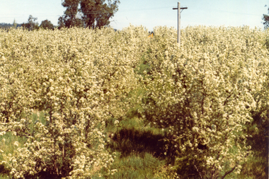 Whitehorse Historical Society Inc.
Photograph, Livermore's Orchard
Coloured photo of blossoms at Livermore's Orchard, Morack Road, Vermontlivermore, douglas, clem, orchards -
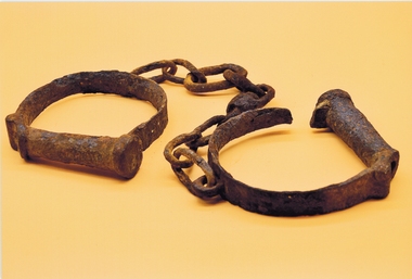 Stawell Historical Society Inc
Photograph, Set of leg irons
Photo of Set of Rusted leg irons found at Deep Lead. Estimated age 1860'scourt, police -
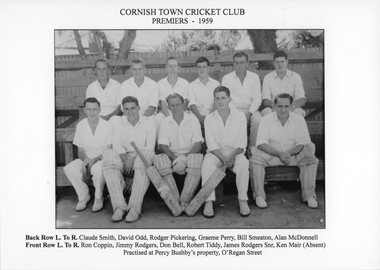 Stawell Historical Society Inc
Photograph, Cornish Town Cricket Club Premiers -- 1959
Cornish Town Cricket Club Premiers – 1959stawell sport -
Stawell Historical Society Inc
Map, Stawell Gold Mines, Stawell Township proposed Town zoning showing Special Uses ( Mining) 1998, 1998
Shows Mining activity Stockpiles Tracks, Plant, Dams, Waste heap, Tailing Dams, IronbarksMap Printed in Colour with Coloured LegendStawell Gold Mines Pty Ltd Date April 1998mining -
 Ringwood and District Historical Society
Photograph, Parking area at the rear of the old Ringwood Library in Pratt St, Ringwood on 10 September 1989
Digital photograph -
Lakes Entrance Regional Historical Society (operating as Lakes Entrance History Centre & Museum)
Photograph, Lakes Post Newspaper, 9/03/1998 12:00:00 AM
Colour photograph of Elizabeth and Brian Blakeman of Tara Bushfoods Weirewa with display of their produce at Gippsland Harvest Festival Power court Maffra Victoriabusinesses -
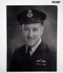 Bendigo Military Museum
Photograph - PHOTOGRAPH, RAAF OFFICER
Photo of "Harold Chatfield" No.401493 RAAF in uniform with notation to wife on bottom corner. Refer Cat 198P, Box 10 for Service details.Dark black and white photo of an Officer in uniform with some writing in bottom corner.Barely legible writing on bottom corner "To My wife Heather....." then unreadable as too faded.photograph, raaf, ww2 -
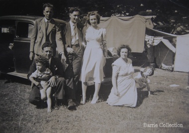 Melton City Libraries
Photograph, Edna and Bon's family camp trip at Apollo Bay, 1948
Wendy Barrie's memories of Apollo Bay The camping trips were a yearly event after the harvest had finished. The trip down to the beach was a much-anticipated event heading out through Parwan and to Geelong leaving behind the hot and dusty plains and our parents relieved to have the hard work of harvesting left behind. The Otways in the distance were reached with great anticipation, Mum in the car and Dad in the Truck ahead of us anxiously winding through the narrow roads and negotiating the hairpin bends and breathing in the cool fresh air of the forest, and keeping an eye out of the log trucks that might come sweeping the corner. The tree ferns with their dripping moisture and the giant trees and the unmistakeable small of the eucalypts. Great excitement was when we caught our first view of the sea from the highest point of the road and then is was the cautious drive the sea level to the sight of the blue ocean with the white of the waves crashing on the rocks and the pristine sand. The water from the Wild Dog and Skenes creek trickling onto the ocean. The tree ferns with their dripping moisture and the giant trees and the unmistakeable smell of the eucalypts. The return journey was usually taken on the Great Ocean Road, it was considered safer to be on the inside of the road. In the early days it was very narrow and passing oncoming cars was taken very cautiously. Landslides and floods sometimes meant we would take the inland route. One year the bridges were washed away and bailey bridges were erected to keep the road open. Rock falls off the cliffs were common Stops on the way home gave us our last chance for our feet in the sand and a swim in the ocean. By the time we reached the hill at Angle Sea the vast blue ocean was behind us and we trekked back through Geelong- Bacchus road and the plains of stubble and the dry grass, and sometimes evidence of burnt patches from a bush fire. The closest we came to a pool at home was the concrete sheep trough at the gate to the work sheds. It was filled with bore water pumped from the nearby windmill. Edna, Bon and their family members at their camp site in Apollo Baylocal identities -
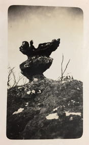 Kew Historical Society Inc
Photograph - Grampians, 1924
Henry Beater Christian (1886-1962) , was a descendant of one of the earliest settler families in Kew. Employed at the Kew Asylum as a 'public servant', he was a skilled amateur photographer, photographing numerous scenes in Kew and on his travels around Victoria. The majority of his photographs date from 1916 to 1929. His finest photographs are housed in two photograph albums. Digital copy of a photograph from page 12 of the 47-page photograph album containing 261 gelatinous silver images, loaned by Diane Washfold with permission given to digitise and hold a copy in our collection. The first and last pages in the album document the Yarra River at Studley Park and at Kew. The remainder of the album includes photographs of walking and car tours in rural Victoria including 'wilderness' areas in the Grampians, Gippsland and the High Country. Six album pages document a camping trip by Henry Christian to the Grampians in September 1924. The photos include pictures of lookouts, and natural features including rock faces and waterfalls, as well as his camp site. This photo is of a self-standing rock on what is probably the Mt Victory trail. "Mt Victory / Grampians / 9.24"henry beater christian (1886-1962), landscape photography, christian-washfold collection, photograph albums, grampians, mt victory, gariwerd -
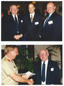 Melbourne Legacy
Photograph - Photo, Legacy Appeal, Media Launch 1998, 1998
A function at Legacy House, including a lunch. From the Post-It note it is the launch of Badge Week in 1998, Tom Butcher is the president. (See also 00747 and 00749). It would appear that elderly Hazel McKean is a guest of honour, she is a World War I widow. 00748.1 President Tom Butcher, Tim Lane (journalist from ABC Sport) and Legacy CEO David Cull. 00748.2 Tom Butcher receiving a cheque from Col Bruce Amor. 00748.3 Gwen Watt and L/- Allan Couper 00748.4 Unknown and President Tom Butcher. 00748.5 Elaine Ward and Gwen Watt 00748.6 Unknown, L/- Alan Fookes and L/- Allan Couper 00748.7 David Cull, Peter Lawrence and Lucky Luscombe. 00748.8 Graham Riches, and 3 unknown. 00748.9 Six people seated at a dining table, including on the right Ray Ward and David Cull. They are sitting in front of a banner "Legacy, 75th Anniversary, Still Caring". 00748.10 Three people seatedA record of a function at Legacy House in 1998. Colour photo x 10 of guests at Legacy house.Printing on the back " -
 Federation University Historical Collection
Photograph - Photograph - Black and White, M.B. John Building, Federation University SMB Campus, c1992, c1989
Morgan Bevan John was a president of the Ballarat School of Mines for many years. In 2014 the building was used for Ceramics and 3D Art, other former uses now being carried out in the Skills Centre. The M.B. John Trade–Art building (Albert Street front) of SMB was officially opened by the Hon. John Cain, Premier of Victoria, in the presence of Morgan B. John. Programs include 3 Dimensional Art, Painting & Decorating, and Engineering Trades. (SMB Institutional Plan 1989)Two black and white photographs of the MB John building at Federation University SMB campus. The building fronts Albert Street, Ballarat. .2) shows the edge of the Ballarat School of Mines Botanical Gardens.ballarat school of mines, john, ballarat school of mines botanical gardens, flecknoe, m.b. john, vocational skills, morgan b. john, albert street, buildings -
 Stawell Historical Society Inc
Photograph, Mr Hec or Harold Wilson with Darlington Road Stawell in the background
Wilson – Hec or Harold – Darlington Road in Background. The building in background could be the Cyanide works.stawell -
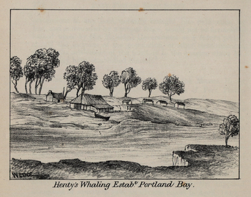 Federation University Historical Collection
Photograph - Image, John Helder Wedge, Portland Bay and Henty's House, 1835
From Westgarth's 'Port Phillip Settlement'.Three images of Portland Bay, including Henty's House, Whaling, and the Fishery. The Hentys were some of the earliest white settlers in the Port Phillip District of New South Wales (later Victoria).wedge, john helder wedge, portland, portland bay, fishery, henty, whaling, victoria, port phillip district -
Stawell Historical Society Inc
Archive, Mining Surveyor’s and Registrar’s Reports 1859-1871, 1859 - 1871
None for year 1867stawell, mining -
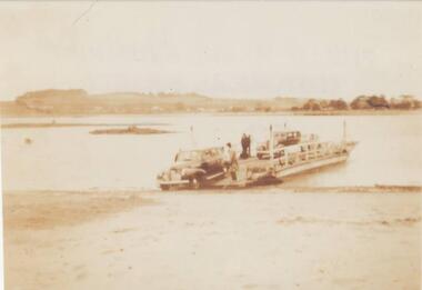 Phillip Island and District Historical Society Inc.
Photograph, 1930's
One of a collection of 6 photographs donated by Mary KarneySepia photograph of the Newhaven to San Remo Punt. Low tide. Cars driving off the Punt at Newhaven with San Remo in the background.san remo - newhaven punt, newhaven foreshore, san remo, car punt phillip island, mary karney -
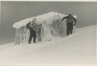 Falls Creek Historical Society
Photograph - Bogong Trip 1951- At Summit Hut
MEYER COLLECTION - FALLS CREEK PHOTOS In 1947 a determined group of like-minded State Electricity Commission (SEC) staff including Ray Meyer, the chief surveyor of the Kiewa Hydro-Electric Scheme, had a common interest that revolved around the skiing potential of the snow-covered high plains which included what is now the resort of Falls Creek. The six SEC employees, Toni St Elmo, Ray Meyer, Jack Minogue, Lloyd Dunn, Adrian Ruffenacht and Dave Gibson (together with their families) banded together to secretly build a 'hut' that was the first ski lodge at Falls Creek. Using a road built in 1930s to gain access to Falls Creek, their hut project was carried out in secret as efforts by other skiers were blocked by H.H.C. Williams – the engineer in charge of the Hydro Scheme. In 1946 Ray Meyer made a trip to the Lands Office in Melbourne. He came away with a 99-year lease on three acres that was ideally suited for a hut designed by Lloyd Dunn. Adrian Ruffenacht (Design Engineer for the KHS) had suggested where the group should build because of easy access to a spring for water. Much of the building material required was scavenged from derelict huts on the high plains. Due to the need for secrecy, the determined group worked on the hut in the evenings and weekends to avoid detection. During the building period the group had met at Echidna Rock (now known as Eagle Rock) where Skippy St Elmo announced, "This is my favourite ‘Skyline’.” And so the first lodge in the area at Falls Creek Ski Resort came into existence. With the development of the International Poma in the 1970s, the Skyline Lodge, which was sited between the ski-lift’s pole one and pole two, was demolished. However, the legacy of Ray Meyer, Toni St Elmo, Jack Minogue, Lloyd Dunn, Adrian Ruffenacht and Dave Gibson and Skyline lives on in the vibrant atmosphere of Falls Creek Resort. The MEYER COLLECTION documents developments on the Kiewa Hydro Scheme and their life at Falls Creek from the mid 1930s to 1960s.This image is significant because it depicts aspects of the life of a pioneering family of Falls Creek and the founders of "Skyline", the first lodge at Falls Creek.Black and White Images taken at Summit Hut. Photo 1. Summit Hut Mt. Bogong - Ray Meyer and Wal Johnson. Photo 2. Summit Hut Mt. Bogong - Ray Meyer The Summit Hut was funded by Howard Michell and built in the 1940's. It was deliberately burnt down in the early 1980's. falls creek, bogong high plains, summit hut, wal johnson