We acknowledge the Traditional Owners of the place now called Victoria, and all First Peoples living and working on this land.
We celebrate the history and contemporary creativity of the world’s oldest living culture and pay respect to Elders — past, present and future.
Please be aware that this website may contain culturally sensitive material — images, voices and information provided by now deceased persons.
Content also may include images and film of places that may cause sorrow.
Aboriginal and Torres Strait Islander people are advised that this website may contain culturally sensitive material — images, voices and information provided by now deceased persons. Content also may include images and film of places that may cause sorrow.
Some material may contain terms that reflect authors’ views, or those of the period in which the item was written
or recorded but may not be considered appropriate today. These views are not necessarily the views of Victorian Collections.
Users of this site should be aware that in many areas of Australia, reproduction of the names and photographs of deceased people is restricted during a period of mourning. The length of this time varies and is determined by the community.
Reuse of any Aboriginal or Torres Strait Islander material on this site may require cultural clearances. Users are advised to contact the source organisation to discuss appropriate reuse.
Plan, Charles Clay, Borough Surveyor, Elevation of Proposed Fence to Station Place Reserve, c. 1881
88 - Elevation of Proposed Fence to Station Place Reserve
Reuse this media
Can you reuse this media without permission?Yes
Conditions of use
Attribution-NonCommercial-NoDerivatives 4.0 International (CC BY-NC-ND 4.0)
This media item is licensed under Attribution-NonCommercial-NoDerivatives 4.0 International (CC BY-NC-ND 4.0). You may share (i.e. copy, distribute, transmit) this item provided that you attribute the content source and copyright holder; do not use the content for commercial purposes; and do not rework (i.e. alter, transform, build upon) the material.
Attribution
Please acknowledge the item’s source, creator and title (where known)
Port Melbourne Historical and Preservation Collection
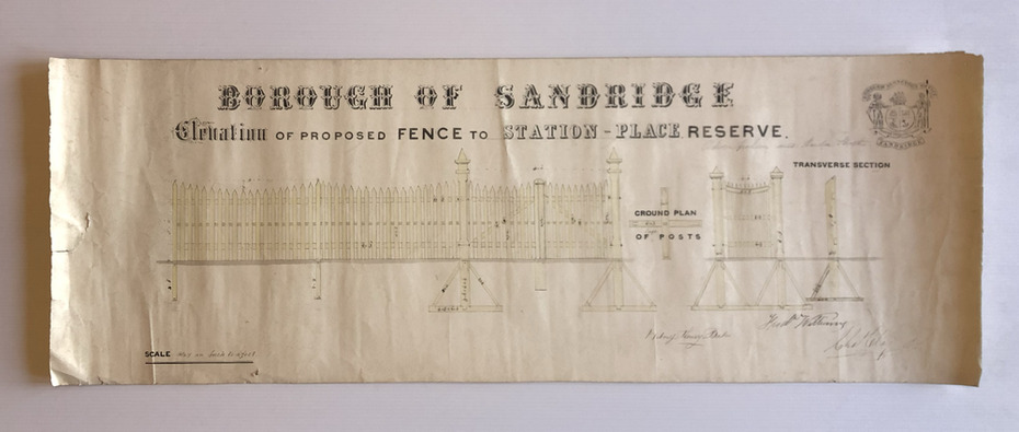
Although undated, the plan is probably from 1880-81.
The plan is signed by Charles CLAY, Fred WILLIAMS and Witney Henry BATES. Charles CLAY was the Borough Surveyor from 1860 to 1884. Fred WILLIAMS was a Councillor 1875 to 1886 and served as Mayor, 1880-81. It is not known who Witney Henry BATES was.
A note in pencil, probably added later, indicates the fence was between Graham and Bridge Streets.
Physical description
Undated Borough of Sandridge hand-drawn plan for a proposed picket fence at Station Place Reserve.
Inscriptions & markings
'between Graham and Bridge Streets' handwritten in pencil below and to the right of the main title.
Victorian Collections acknowledges the Australian Aboriginal and Torres Strait Islander
peoples as the first inhabitants of the nation and the traditional custodians of the lands
where we live, learn and work.