-
 Uniting Church Archives - Synod of Victoria
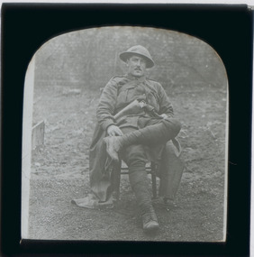
Negative - Glass plate negative, Unknown WWI soldier, 1916 - 1918
Glass negative with image of unidentified seated soldier. The soldier is wearing the Brodie pattern steel helmet issued to Australian soldiers on the Western Front 1916 - 1918.first world war, ww1, world war one -
 Bendigo Historical Society Inc.
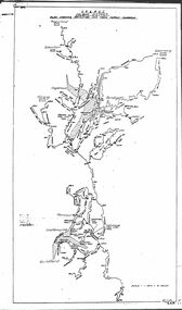
Map - STATE RIVERS AND WATER COMMISSION : COLIBAN DISTRICT IRRIGATION AND TOWN SUPPLY CHANNELS, 30/11/1956
State Rivers and Water Supply Commission. Foolscap-size map. Title : Coliban district Plan showing Irrigation and Town Supply Channels. The map covers the area from Raywood to Guildford. Scale : 1 inch to 4 miles. Dated 30/11/56, number 5,491 in bottom right corner.state infrastructure, water supply, coliban system, state rivers and water supply commission. coliban system. -
 University of Melbourne, Burnley Campus Archives
Plan - Photocopy, Sketch Plan, 1929
Photocopy of hand drawn plan of Section of Site indicating proposed irrigation. Probably from A.W. Jessep memos 1929.irrigation, a.w. jessep -
 Ballarat Tramway Museum
Negative, Wal Jack, late 1930's or early 1940's
Yields information about the tram that was to become the gold tram in 1951, in general passenger service.Negative and Digital image of the Wal Jack Ballarat Negative file of No. 23 inbound in Sturt St West to the city, about to stop to pick up two school girls at a tram stop. Has Victoria Park in the background. trams, tramways, sturt st west, victoria park, schools, tram stops, tram 23 -
Port Melbourne Historical & Preservation Society
Archive - Port 'n' South Living and Learning Centre, 1985 - 1995
The centre was one of several community groups established in the mid 1980's. After 1998 when the Baptist Church decided to discontinue the relationship, co-ordinator Julie Allen donated the minutes, brochures, photos and other records to the society.From archive box containing the archives of the Port 'n' South Living and Learning Centre located at the Ross St Baptist church, 1985 to 1998. Also includes item 1207 (various files listed on separate attachment) Refer also to items 1084 and 819 and 1207. .13 - Colour photo of committee member Pat Grainger at fete stall in halleducation, community, education - adult, societies clubs unions and other organisations, religion - baptist church, pat grainger -
Port Melbourne Historical & Preservation Society
Plan - Sandridge, 1860
Original would have belonged to Joseph Turner, City Valuer 19th century and grandfather of member Ken Turner, who now holds original that he loaned to us for copying in 1998.Photocopy made from 1860 plan of Sandridge with proposals for various lots beyond the Lagoon, beyond the railway and even on the Railway Reservetown planning, built environment, joseph turner, land sales -
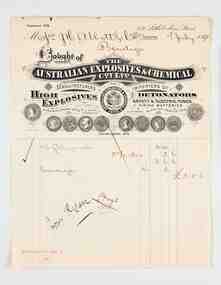 City of Greater Bendigo - Civic Collection
Financial record - Invoice, The Australian Explosives & Chemical Co, The Australian Explosives & Chemical Coy Ltd, 1898
Joseph Henry Abbott arrived in Australia from Birmingham England in 1852 aged 22 hoping to make his fortune on the goldfields. In 1853 he opened a store in Bendigo, Abbott and Co and from there began a lengthy career as a business man supplying the local community with goods and services including owning and operating the New Times Boot Market & Factory in Pall Mall, Sandhurst, run by his wife, Anne (nee Deague). J H Abbott’s main ambitions were to serve on the local and state councils. He was elected Chairman of the Sandhurst Borough Council in 1860, Mayor of the City of Bendigo in 1891 and was gazetted a Justice of the Peace in 1864. Over his lifetime J H Abbott was closely linked to nearly all the leading institutions in Bendigo and worked for the benefit of local charities. He was trustee of the Bendigo Art Gallery and a Freemason and was said to be the first person in Bendigo to have a telephone installed in1882 between his residence and his business in Pall Mall. After JH Abbott died in 1904 he passed on his businesses to his son JH Abbott Jnr and adopted son RHS Abbott. These businesses continued to trade under the name JH Abbott & Co and today still operates under the name Abbott Supply although the last of the family interests ceased in 1986. Abbott and Co acted as agents for larger Melbourne based suppliers such as Briscoe & Co and the Australian Explosives & Chemical Co. Printed and handwritten paper invoice from Australian Explosives & Chemical Co to JH Abbott & Co dated 7th July, 1898 for the purchase of dynamite and gelignite. The invoice artwork/ letterhead and layout is especially notable due to its association with Troedel & Co, Master Printers and Lithographers and pioneers of the Melbourne printing industry.city of bendigo mayor, shire of strathfieldsaye, mayor abbott, city of greater bendigo commerce, making a nation exhibition, briscoe & co, australian explosives & chemical co -
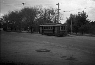
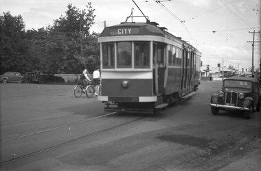 Ballarat Tramway Museum
Negative, Wal Jack, late 1945
Yields information about the appearance of the ex Melbourne bogie trams during the initial period of operations in Ballarat.Negative and Digital image of the Wal Jack Ballarat Negative file of bogie car, most likely ex Melbourne 117, future 22 at the intersection of Wendouree Parade, Ripon and Webster Streets. Tram has the destination of city. Late 1945. It would appear that the sides of the tram have been painted but not the rear end, still has the MMTB War time markings on the tram. trams, tramways, wendouree parade, new trams, webster st, ripon st, bogie trams, tram 22 tram 117 -
Stawell Historical Society Inc
Archive - Certificate, Nurses Training Certificate May Booth January 1919, 22-1-1919
May Booth trained at the Pleasant Creek Hospital from around 1915Certificate with picture of Stawell Hospital & Benevolent Asylum - Pleasant Creek HospitalMay Booth Raymond Bell? G Barnes Catherine Wren W M Bellnursing, medical, hospital -
Stawell Historical Society Inc
Archive - CD/DVD, Gold Mining Relics of the Past - Surface and underground. Plan view of underground mine. Photographs of various mine sites. Underground workings of various mines, 2003
stawell, mines, relics, stokes, timbers -
 Kew Historical Society Inc
Plan, Melbourne & Metropolitan Board of Works : Borough of Kew : Detail Plan No.1563, 1905
The Melbourne and Metropolitan Board of Works (MMBW) plans were produced from the 1890s to the 1950s. They were crucial to the design and development of Melbourne's sewerage and drainage system. The plans, at a scale of 40 feet to 1 inch (1:480), provide a detailed historical record of Melbourne streetscapes and environmental features. Each plan covers one or two street blocks (roughly six streets), showing details of buildings, including garden layouts and ownership boundaries, and features such as laneways, drains, bridges, parks, municipal boundaries and other prominent landmarks as they existed at the time each plan was produced. (Source: State Library of Victoria)This plan forms part of a large group of MMBW plans and maps that was donated to the Society by the Mr Poulter, City Engineer of the City of Kew in 1989. Within this collection, thirty-five hand-coloured plans, backed with linen, are of statewide significance as they include annotations that provide details of construction materials used in buildings in the first decade of the 20th century as well as additional information about land ownership and usage. The copies in the Public Record Office Victoria and the State Library of Victoria are monochrome versions which do not denote building materials so that the maps in this collection are invaluable and unique tools for researchers and heritage consultants. A number of the plans are not held in the collection of the State Library of Victoria so they have the additional attribute of rarity.Original survey plan, issued by the MMBW to a contractor with responsibility for constructing sewers in the area identified on the plan within the Borough of Kew. The plan was at some stage hand-coloured, possibly by the contractor, but more likely by officers working in the Engineering Department of the Borough and later Town, then City of Kew. The hand-coloured sections of buildings on the plan were used to denote masonry or brick constructions (pink), weatherboard constructions (yellow), and public buildings (grey). This plan covers the area between Barkers Road, Wrixon Street, Sackville Street and Brougham Place, much of it now occupied by Carey Baptist Grammar and Preshil schools. This was an area of large and prestigious homes in 1903, some with formally laid-out gardens, such as ‘Tower Hill’ and ‘Opawa’. ‘Kalimna’ was built in 1890-91 for William H. Jarman, an accountant, and ‘Blackhall’ at the same time for W.H. Roberts. Blackhall was to be acquired by the Salvation Army in 1915 and renamed ‘Catherine Booth Girls’ Home’. The Home accommodated girls, aged between 4 and 16. Kalimna and Blackhall are of significance as typical and intact late Victorian mansions and as such are two key Victorian buildings to have been built in Kew. Both Blackhall and Kalimna are now part of Preshil. ‘Fairview’ was for a long time occupied by the Sisters of St. Joseph of Cluny as a care home for the elderly, but it is now part of Carey Grammar School, as are the grounds of ‘Wagga Merne’, ‘Weemutta’, ‘Blakely’, ‘Daheim’ and ‘Mildura’ (later ‘Urangeline’), the last being particularly impressive in 1903, with a tennis court, conservatory, outhouses, and two bathrooms!melbourne and metropolitan board of works, detail plans, mmbw 1563, cartography -
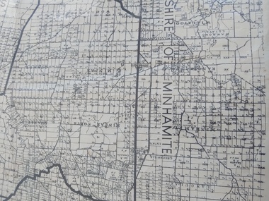 Peterborough History Group
Map - Shire of Warrnambool
Map of the area, when Peterborough was part of Warrnambool ShireHistoric map of the area when Peterborough was in the Warrnambool ShireA3 size map, larger view of the whole shire of Warrnambool, and includes adjoining Shire Boundaries. Shows individual land allotments.peterborough, warrnambool shire, old maps -
Bendigo Historical Society Inc.
Map - WOODSTOCK : COUNTY OF BENDIGO, 4-7-35
Map. Woodstock, County of Bendigo, Derby, Leichardt, Marong, Shelbourne, Laanecoorie, Tarnagulla. Bradford Creek, Maldon and Laanecoorie Railway. Drawn and reproduced at the Department of Lands and Survey, Melbourne, Victoria.4-7-35. Price 2/-. By authority H.J. Green,Govt. Printer. (number 41 in map cupboard 1)H.J. Green, Govt. Printer.map, bendigo, woodstock -
Bendigo Historical Society Inc.
Map - NEILBOROUGH, October 21 1859
Map:Township of Neilborough, Elysian Flat, near Sandhurst,County unnamed. Parish plan.Backing is a part of another parish mapmap, bendigo, neilborough, elysian flat -
 Kew Historical Society Inc
Plan, Melbourne & Metropolitan Board of Works : Borough of Kew : Detail Plan No.1572, 1905
The Melbourne and Metropolitan Board of Works (MMBW) plans were produced from the 1890s to the 1950s. They were crucial to the design and development of Melbourne's sewerage and drainage system. The plans, at a scale of 40 feet to 1 inch (1:480), provide a detailed historical record of Melbourne streetscapes and environmental features. Each plan covers one or two street blocks (roughly six streets), showing details of buildings, including garden layouts and ownership boundaries, and features such as laneways, drains, bridges, parks, municipal boundaries and other prominent landmarks as they existed at the time each plan was produced. (Source: State Library of Victoria)This plan forms part of a large group of MMBW plans and maps that was donated to the Society by the Mr Poulter, City Engineer of the City of Kew in 1989. Within this collection, thirty-five hand-coloured plans, backed with linen, are of statewide significance as they include annotations that provide details of construction materials used in buildings in the first decade of the 20th century as well as additional information about land ownership and usage. The copies in the Public Record Office Victoria and the State Library of Victoria are monochrome versions which do not denote building materials so that the maps in this collection are invaluable and unique tools for researchers and heritage consultants. A number of the plans are not held in the collection of the State Library of Victoria so they have the additional attribute of rarity.Original survey plan, issued by the MMBW to a contractor with responsibility for constructing sewers in the area identified on the plan within the Borough of Kew. The plan was at some stage hand-coloured, possibly by the contractor, but more likely by officers working in the Engineering Department of the Borough and later Town, then City of Kew. The hand-coloured sections of buildings on the plan were used to denote masonry or brick constructions (pink), weatherboard constructions (yellow), and public buildings (grey). Plan No. 1572 represents the built environment bordered by Barkers Road, Wrixon Street, Edgevale Road and Fitzwilliam Street. Other streets identified on the plan include Stansell Street. Plan 1572 shows that by 1903-05, there was only patchy development in this area of Kew, mainly on Edgevale Road and Fitzwilliam Street. Only two named houses are identified: the quaintly named ‘Tweed Cottage’, and ‘Mendip’. The earliest reference to Treed Cottage in Australian newspapers is to the death of Walter Thompson, aged 74 who was a resident there in 1885. His youngest daughter was to die there in 1908. Mendip to the north of Tweed Cottage was owned by Henry Thompson; he was to die in 1901; his wife in 1932. At this period of time, Malin Street and Clivedon Court did not extend to Barkers Road.melbourne and metropolitan board of works, detail plans, mmbw 1572, cartography -
Stawell Historical Society Inc
Archive - CD/DVD, West Mitchell Family photographs with names, 2012
stawell -
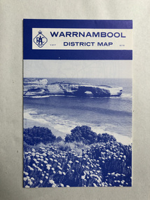 Robin Boyd Foundation
Map, RACV, Warrnambool District Map
walsh st library -
Bendigo Historical Society Inc.
Map - MUSKERRY : COUNTY OF BENDIGO, 1962
Map. Muskerry, County of Bendigo, County of Rodney, Goornong, Ellesmere, Axedale, Weston, Crosbie, Toolleen, Campaspe, Forest or Mannering Creek, Back Creek, Campaspe River. By authority A.C. Brooks, Government Printer, Melbourne. Drawn and reproduced at the Department of Lands and Survey, Melbourne, 1962. Price 2/-. (number 110 in map cupboard 1)A.C. Brooks, Government Printer, Melbourne.map, bendigo, muskerry -
Bendigo Historical Society Inc.
Map - RAVENSWOOD : COUNTY OF BENDIGO, 28-7-14
Map. Ravenswood, County of Bendigo, County of Talbot, Lockwood, Sutton Grange, Harcourt, Walmer, Bradford, Shelbourne, Mandurang, Photo-Lithographed at the Department of Lands and Survey by T.F. McGauran 28-7-14. (number 86 in map cupboard 1)T.F. McGauranmap, bendigo, ravenswood -
Port Melbourne Historical & Preservation Society
Plan - Annotated and handcoloured by Peter Libbis to indicate his research into Libbis family residences and hotels on copy of a section of an MMBW map, Melbourne and Metropolitan Board of Works, c. 1980s
Peter LIBBIS obtained these copies from the MMBW when he researched his family history in the 1980s. He has annotated them, colour in hotels etc. Donated to Society in 1997.One of a group of 19 photocopies of various 20th century MMBW plans, annotated/coloured in to indicate residences of Libbis family and local hotels, by Peter LIBBIS in family and hotel research - Harper's and lagoon, 1950s?business and traders - hotels, built environment - domestic, transport - railways, melbourne and metropolitan board of works, libbis family -
Kew Historical Society Inc
Archive (Series) - Opportunity Shops [Kew]
Various PartiesReference, Research, InformationArranged by Secondary Values (value of records to users)Opportunity Shops (Op Shops) are second-hand stores that take donations and sell them to the community for less than normal retail. The file includes: Newspaper articles and letters to the editor about Op Shops in Kew.opportunity shops -- kew (vic.)opportunity shops -- kew (vic.) -
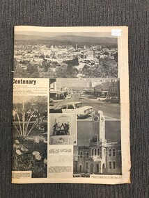 Stawell Historical Society Inc
Archive - Newspaper Supplement, Stawell Centenary: Weekly Times 1969
Origanl Cat No: 238Newspaper Pages from The Weekly Times November 12 1969 Pages 51 -54Stawell Centenarystawell, centenary -
University of Melbourne, Burnley Campus Archives
Plan, Kate Blood, City of Werribee Proposal for a Monument to Mark the Proclamation of Werribee as a City, 1987
Coloured elevation by Kate Blood dated 16.04.1987kate blood, werribee -
Port Melbourne Historical & Preservation Society
Plan - Evans Street from ingles Street to Boundary Street, 1893 - 1919
Plan of Evans Street from Ingles Street to Boundary Street 1893..engineering - roads streets lanes and footpaths -
Port Melbourne Historical & Preservation Society
Archive, Port People Archive, 2008 - 2019
Official records of port People Inc. Port people were an activist group formed because of concerns over Council intentions for Garden City reserve.Port People Archive six folders .03 black cover PPI, Port people on spine Minutes 2013 - 2016; AGM minutes 2007 - 2019; Celebrations in the Park miknutes ; Membership lists 2009 -2015; invoices Attached sheet has detailed contents of folders and also on USB stick. Supplementary file has a list of significant issues contained in the dicuments as considered by Rowan Groves, President.built environment, local government - city of port phillip, parks and gardens, public action campaigns, port people inc, rowan groves - president, garden city, garden city reserve -
Kew Historical Society Inc
Archive (Sub-series) - Subject File, L'HARDY, Lou
Kew Historical SocietySince its foundation in 1958, members of the Kew Historical Society have been compiling and storing information about subjects relating to the history of Kew and its environs, of which this file is an example. Arranged by Secondary Values (value of records to users)Subject file containing biographical information about Lou L'Hardy (c.1900-1978) who was a foundation member of the Kew Lions Club in 1953. The file also includes an engraved metal plaque mounted on wood awarded for 'sincere and devoted effort' (February 1958). There are a number of 3-Dimensional items relating to him held in other parts of the collection. kew lions club, lou l'hardykew lions club, lou l'hardy -
Glen Eira Historical Society
Plan - Nithsdale
This file contains one item about this property: Three postcard sized photographs of a flyer for the subdivision sale of the area incorporating this property for Saturday 22/11/1924. The flyer shows photographs (black and white) and plan of the area around 'Nithsdale'.nithsdale', caulfield north, hudson street, bambra road, kambrook road, centre way, oak court, caulfield railway station, balaclava road, glenhuntly road, caulfield racecourse -
Whittlesea Historical Society Inc.
Archive - Folder, Maps
Green A4 ring binder folder containing maps numbered 1 - 20. Mapsmap, archive, folder -
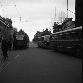 Ballarat Tramway Museum
Negative - Set of 4, Geoff Grant, 25/06/1955 12:00:00 AM
Negatives No. N345 to N348 and black and white prints made by a laser printer (stored in folder ) of AETA tour (Australian Electric Traction Association) on 25/6/1955 at Spencer St. terminus. Both trams have AETA tour signs and the slogan "Save traffic congestion, Move People not vehicles" 1611.1 - 980 at terminal with two buses (ET 330? and bus 585) alongside and Eliza Tinsley building in the background. 1611.2 - 980 and part of W7 1001. 1611.3 - 980 and 1001 at terminal with a bus standing alongside the Mail Exchange building. 1611.4 - 980 at terminal with tour passengers standing around. Negative scanned hi res and imaged updated 22/5/2020.trams, tramways, melbourne, bourke st, spencer st, aeta tour, tram 980 tram w7 1001 -
 Stawell Historical Society Inc
Archive, Freeland Bros Debtors Ledger Cash Book and Summary Financial Statement (1912-1913 and 1961-1969), 1912 - 1913 and 1961 - 1969
stawell, business