Archive - Folder, Maps
Other parts of this item
-
Whittlesea Historical Society Inc.
Archive - Box, Whittlesea Historical Society - WHS - Maps. 1
Archive Box with lid - Whittlesea Historical Society - WHS - Maps. 1. Contents: 1. Green binder Folder, labelled "Maps", with inventory of contents. Contents: 1. Map Parish of Keelbundora, 11 June 1956, large sheet 2. Map Parish of Keelbundora, undated, one sheet 3. Map Parish of Keelbundora, 1946 4. Map Parish of Keelbundora 5. Map Parish of Keelbundora, 5 Jun 1953 6. Map Parish of Keelbundora, blue sheet 7. Morang - Portions 11-14, A4 page 8. Golden Wattle Estate, 23 Feb 1962, A3 sheet 9. Range View Estate, A4 sheet 10. Golden Wattle Ranges Estate, 22 Feb 1962, A4 sheet 11. Golden Wattle Estate Hurstbridge, A3 12. Shire of Whittlesea including Epping Station, Nov 86, A3 13. Whittlesea, including Epping Road, A3 14. Station Estate Thomastown including Thomastown Railway Station 15. Station Estate Thomastown including Thomastown Railway Station 16. Thomastown Estate, date prior to decimal currency, A3 poster 17. Certificate of Title - Thomastown Station subdivision, 18 Oct 1926, Transfer of Lands Act Titles 18. Plan of Subdivison of Stages 1 & 2 Thomastown 19. Poster - Auction Sale Thomastown, 27 Oct 1923 20. Thomastown, 24 Nov 1907.
Grey coloured Archive Box containing maps
Whittlesea Historical Society - WHS - Maps. Box 1.
map, archive, achival box
-
 Whittlesea Historical Society Inc.
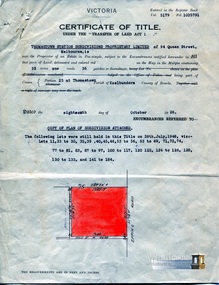
Document - Certificate of Title, Certificate of Title, Vol. 5179 Fol. 1035791, 18 Oct 1926
Title in the name of Thomastown Station Subdivisions Propriety Limited of 94 Queen Street, Melbourne, 32 acres being part of Portion 25 at Thomastown, Parish of Keelbundora County of Bourke, dated 18th October 1926.
1 p. colour
subdivision, thomastown, thomastown station subdivisions, epping road, main street thomastown, portion 25 thomastown
-
 Whittlesea Historical Society Inc.
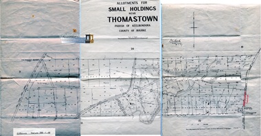
Map - Allotments for Small Holdings, near Thomastown, Parish of Keelbundora, County of Bourke, 24 Nov 1907
1 sheet, folded. Map 20 of 20 in green folder. Shows sizes of the blocks, between Yan Yean Pipe Track to the west and Plenty Road Bundoora to the east.
J. V. Smith. Photo - lithographed at the Department of Lands and Survey Melbourne by T. F. McGauran. 4.12.07.
map, yan yean pipe track, plenty road bundoora, maroondah aqueduct
Other items from this collection
-
 Whittlesea Historical Society Inc.
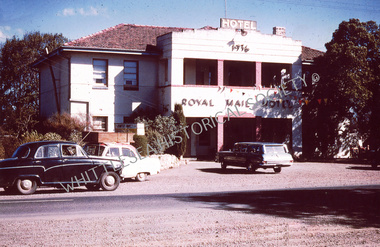
Photograph, Royal Mail Hotel, Whittlesea. C.1970's
Royal Mail Hotel, Whittlesea. C.1970's
-
 Whittlesea Historical Society Inc.
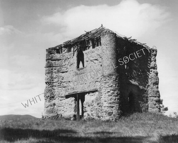
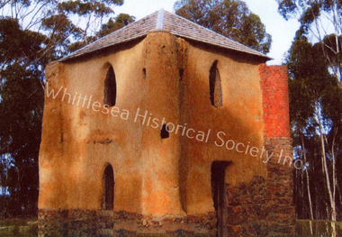
Photograph, Bear's Castle. Date unknown
Bear's Castle, Yan Yean. Date Unknown
-
 Whittlesea Historical Society Inc.
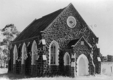
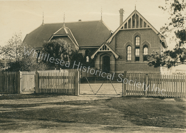
Photograph, Janefield Presbyterian Church. Date unknown
Janefield Presbyterian Church. Date unknown
-
 Whittlesea Historical Society Inc.
Photograph, Thompson's Boot making & Saddlery Store
Thompson's Boot making & Saddlery Store. Date unknown
-
 Whittlesea Historical Society Inc.
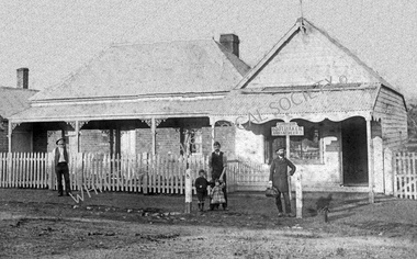
Photograph, Smith's Butcher Shop, South Morang. Year unknown
Smith's Butcher Shop, South Morang. Year unknown
-
 Whittlesea Historical Society Inc.
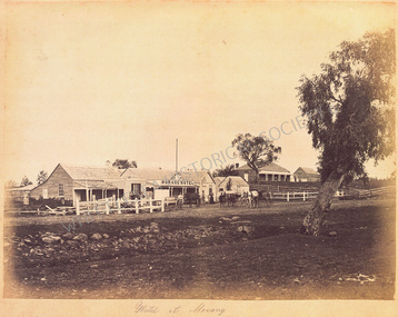
Photograph - C. 1860's. Grant's Morang Hotel
C. 1860’s. Grant’s Morang Hotel, Morang
-
 Whittlesea Historical Society Inc.
Photograph, 2019, Bear's Castle, Yan Yean Reservoir
2019, Bear's Castle, Yan Yean Reservoir
-
 Whittlesea Historical Society Inc.
Photograph, Whittlesea State School No. 2090
Whittlesea State School No. 2090 (date unknown)
-
 Whittlesea Historical Society Inc.
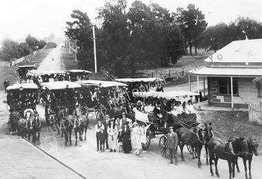
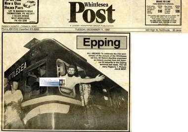
Newspaper - Newspaper clipping, Ken Jeffery, Epping All Aboard
To celebrate the 31st anniversary of the of the closure of the Whittlesea rail line, Robert Aquilina organised an historic journey from the Spencer Street railyards to the Epping terminus.
3 pages newsprint with images.
Epping All Aboard
whittlesea rail line, robert aquilina, epping rail terminus, number 55 rail motor, mrs rosemary hall, ray jeffrey, arthur jeffrey, ken jeffery
-
 Whittlesea Historical Society Inc.
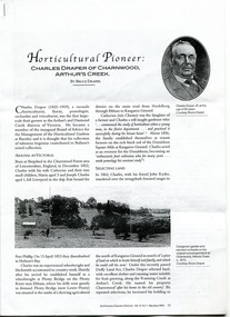
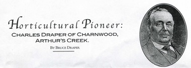
Document - Copy, Australian Garden History, Horticultural Pioneer Charles Draper of Charnwood Arthurs Creek, May/Jun 2004
Horticultural Pioneer Charles Draper of Charnwood, Arthurs Creek. By Bruce Draper. Published in Australian Garden History Vol. 15 No. 5 May/June 2004.
6 pages photocopied.
Horticultural Pioneer Charles Draper of Charnwood, Arthurs Creek. By Bruce Draper.
charles draper, draper family, bruce draper, charnwood arthurs creek, fruit grower, reid family
-
 Whittlesea Historical Society Inc.
Document - pdf, Australian Garden History, Horticultural Pioneer Charles Draper of Charnwood Arthurs Creek, May/Jun 2004
Horticultural Pioneer Charles Draper of Charnwood, Arthurs Creek. By Bruce Draper. Published in Australian Garden History Vol. 15 No. 5 May/June 2004.
.pdf document
Horticultural Pioneer Charles Draper of Charnwood, Arthurs Creek. By Bruce Draper.
charles draper, draper family, bruce draper, charnwood arthurs creek, fruit grower
-
 Whittlesea Historical Society Inc.
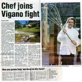
Newspaper - Newspaper clipping, Whittlesea Leader, Chef joins Vigano fight, 27 Sep 2005
A newspaper article on the restoration of the historic Farm Vigano in South Morang. Florentino chef Guy Grossi agreed to become a patron of Farm Vigano.
Historical building of South Morang.
1 page newsprint with coloured images.
Chef joins Vigano fight
farm vigano, vigano family, south morang, maria theresa vigano, mario vigano, italian immigrants, guiliana mercoli
-
 Whittlesea Historical Society Inc.
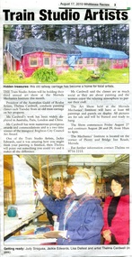
Newspaper - Newspaper clipping, Whittlesea Review, Train Studio Artists, 17 Aug 2010
A newspaper article on the Train Studio Artists holding their third annual art show at the Mernda Mechanics Institute.
1 page newsprint with coloured images.
Train Studio Artists
train studio artists, mernda, mernda mechanics institute, old train carriage, judy siragusa, jackie edwards, lisa dallest, thelma cardwell
-
 Whittlesea Historical Society Inc.
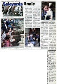
Newspaper - Newspaper clipping, The Free Press, Saleyards finale, 24 Aug 2005
A newspaper article on the closure of the livestock market site at Mernda.
History of Australian Agriculture
1 page newsprint with coloured images.
Saleyards finale
mernda market, mernda saleyards, rod carnegie, quiney family, quiney mawbey, thomas beesely
-
 Whittlesea Historical Society Inc.
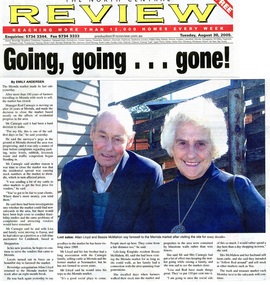
Newspaper - Newspaper clipping, The North Central Review, Going going gone, 30 Aug 2005
A newspaper article on the closure of the livestock market site at Mernda. Allan Lloyd from Beveridge and Bessie McMahon of Kinglake are pictured attending the last day of the market.
1 page newsprint with coloured image.
Going going gone
mernda market, mernda saleyards, rod carnegie, allan lloyd, bessie mcmahon
-
 Whittlesea Historical Society Inc.
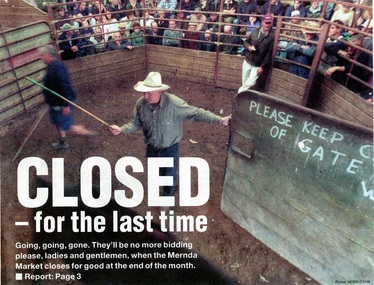
Newspaper - Newspaper clipping, Whittlesea Leader, Closed for the last time, 16 Aug 2005
A newspaper article on the closure of the 117-year-old livestock market at Mernda.
Historic buildings of Mernda.
2 pages newsprint with coloured images.
Closed for the last time
mernda market, mernda saleyards, rod carnegie, quiney family, neil clark
-
 Whittlesea Historical Society Inc.
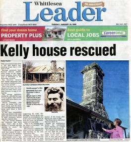
Newspaper - Newspaper clipping, Whittlesea Leader, Kelly House Rescued, 18 Jan 2005
A newspaper article on stabilisation works on Ned Kelly's childhood home in Beveridge by heritage architects.
1 page newsprint with coloured images
Kelly House Rescued
ned kelly house, kelly house at beveridge, beveridge, john kelly, sharon consiglio
-
 Whittlesea Historical Society Inc.
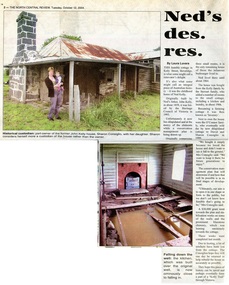
Newspaper - Newspaper clipping, The North Central Review, Ned's des. res, 12 Oct 2004
An article on the dilapidated state of the original childhood home of Ned Kelly, in Kelly Street, Beveridge. Originally built by Ned's father, John Kelly, in about 1859, and now part-owned by Sharon Consiglio.
1 page newsprint with 2 coloured images
Ned's des. res.
ned kelly house, kelly house at beveridge, beveridge, john kelly, sharon consiglio
-
 Whittlesea Historical Society Inc.
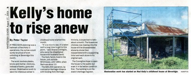
Newspaper - Newspaper clipping, Whittlesea Leader, Kelly's home to rise anew, 17 Aug 2004
Stabilisation work to save Ned Kelly's childhood home in Beveridge.
1 page newsprint with image
Kelly's home to rise anew.
ned kelly house, kelly house at beveridge, beveridge
-
 Whittlesea Historical Society Inc.
Newspaper - Article, Whittlesea Review, Whittlesea dies a little more, 17 Aug 2010
The original Whittlesea Primary School was torn down on 7 August 2010.
Historical building in Whittlesea since demolished.
Newsprint 1 p. text with colour photograph.
Whittlesea dies a little more
whittlesea primary school, demolished
-
 Whittlesea Historical Society Inc.
Newspaper - Article, Whittlesea Weekly, Grave matter, Thomastown Lutheran Church Cemetery, 6 Sep 2005
A giant pine tree blew over at the Thomastown Lutheran Church Cemetery and obliterated the tombstones of the Shultz and Siebel plots. Sylvia Shultz and her son Paul, descendants of both settlers, are pictured.
Newsprint 1 p. text with colour photograph.
Australia Day honour for Whittlesea legend, Les Russell.
thomastown lutheran church cemetery, shultz family, siebel family, sylvia shultz, paul shultz
-
 Whittlesea Historical Society Inc.
Newspaper - Article, Whittlesea Review, Australia Day honour for Whittlesea legend, Les Russell, Feb 2022
Les Russell was posthumously awarded a Medal of the Order of Australia as part of the Australia Day honours list.
Newsprint 1 p. text with colour photograph.
Australia Day honour for Whittlesea legend, Les Russell.
les russell, russell family, order of australia, whittlesea, australia day honour
-
 Whittlesea Historical Society Inc.
Newspaper - Article, Star Weekly News, Honour for lifelong Whittlesea resident, Les Russell, Feb 2022
Les Russell was posthumously awarded a medal of the Order of Australia for his services to the community of Whittlesea.
Newsprint 1 p. text with colour photograph.
les russell, russell family, order of australia, whittlesea
-
 Whittlesea Historical Society Inc.
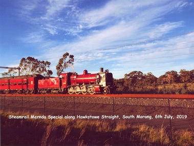
Photograph - Copy, Steamrail at Mernda, 6 Jul 2019
A4 print copy of photograph
Steamrail Mernda Special along Hawkstowe Straight, South Morang, 6th July, 2019
steam train, mernda
-
 Whittlesea Historical Society Inc.
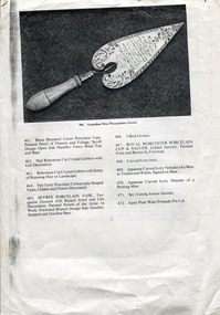
Document, Australian Silver Presentation Trowel
The foundation stone of a new bridge over the Plenty River at Morang (now Mernda) was laid by Mrs. John Wilton of Wilton Vale, in August 1866. The silver trowel was presented to Mrs. Wilton by Moses Thomas, chairman of the road board. The bluestone bridge was officially opened by Moses Thomas on the 12th of February 1867.
The location of the silver trowel in this rare image is unknown.
A4 single page (double sided) with image and a list of items numbered 461 - 495.
Item 486. Important Australian Silver Presentation Trowel., inscribed "Presented to Mr John Wilkin of Wilkin Dale Morang on the Occasion of the Laying of the Foundation Stone, the Bridge of the Plenty River at the Junction of the Parishes of Morang and Yan Yean by the Morang District Road Board, August 1866, Fine Engraved Scroll Decorated Border, Turned Ivory Handle, Maker R. R. Illustrated Page 27.
silver trowel, morang bridge, mernda bridge, john wilton, wilton family, moses thomas, wilton vale
-
 Whittlesea Historical Society Inc.
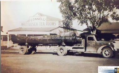
Photograph, Gordon Keith Federal Truck, 1940s
Gordon Keith's truck carting a log outside Connell's Whittlesea Tea Rooms in Whittlesea. After leaving the air force when World War II ended, Gordon Keith started driving trucks. He carted logs and sawn timber from Kinglake, Yea, and Murrindindi to Whittlesea Sawmill, Grange Timber in Northcote, and Fairfield Paper Mills.
Photograph print
gordon keith, federal truck, whittlesea tea rooms, connell family, keith family
-
Whittlesea Historical Society Inc.
Photograph, Bridge over Plenty River at South Morang
Bridge over Plenty River at South Morang.
B&W Copy of photograph print
Bridge over Plenty River at South Morang
bridge, south morang, plenty river
-
 Whittlesea Historical Society Inc.
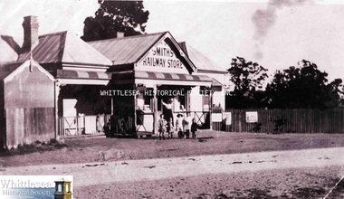
Photograph - Digital Image, Smith's Railway Store, South Morang, c.1920s
Digital image only of Smith's Railway Store, Old Plenty Road, South Morang
Digital image
railway store, smiths store, south morang, smith's railway store
-
 Whittlesea Historical Society Inc.
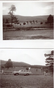
Photograph - Copy, Toorourrong Reservoir, 1930s
A4 sheet of photographic paper with 2 small images of Toorourrong Reservoir printed on the same side.
Reverse: Toorourrong Reservoir Late 1960's Donated copies to WHS
toorourrong reservoir
-
 Whittlesea Historical Society Inc.
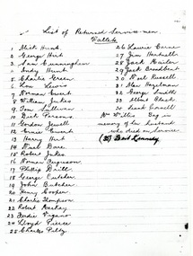
Document, List of Returned Service Men, Wallets, c.1947
One page photocopy: List of Returned Service Men. Wallets. (See: "Letter from Patriotic Funds Council of Victoria to South Morang Soldiers' Welcome Home Patriotic Fund", file.)
List of Returned Service Men Wallets. 1. Alick Hunt 2. George Hirt 3. Sam Cunningham 4. Andy Hunt 5.Charlie Green 6. Lou Lewis 7. Norman Ewert 8. William Jukes 9. Tom Sullivan 10. Dick Parsons 11. Gordon Jewell 12. Ernie Ewert 13. Harry Hirt 14. Noel Dare 15. Robert Jukes 16. Norman Ferguson 17. Phillip Drill 18. George Butcher 19. John Butcher 20. Henry Cooper 21. Charlie Thompson. 22. Robert MacKay 23. Ferdie Vigano 24. Lloyd Pierce 25. Charles Piltz 26. Laurie Carne 27. Jim Hartnell 28. Jack Mailer 29. Jack Broadbent 30. Noel Russell 31. Alan Hazelman 32. George Smith 33. Albert Black 34. Frank Cornell Mrs. Willis Bag in memory of her husband who died on Service (35) Bert Kennedy
south morang soldiers' welcome home patriotic fund, patriotic funds council of victoria, returned service men, ww2, second world war