-
 Bendigo Historical Society Inc.
Journal - Dicker's Mining Journal 1862
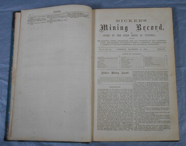
Thomas Dicker, Rowan Street, Bendigo, published a monthly mining journal that included geological information, mine details and mining practises for particular mining districts. In 1868/9, Dicker moved to England to open the "Australian and London Mining Agency" with the goals of promoting investment in Victorian mines, entering Victorian mining shares on the London Stock market, and exploring the latest in mining technology that might be suitable for mining in Victoria.Dicker's Mining Record and guide to the gold mines of Victoria, showing the bearings, depths, thickness, dips and underlies of the auriferous lodes; the progress and cost of works in operation; containing also a variety of valuable interesting and statistical information. Published by the proprietor, Thomas Dicker, Rowan Street Sandhurst. A green with black spine hardcover book. Paper glued on the front with the title Dicker's Mining Journal 1862. On the spine in gold lettering Dicker's Mining Record Vol.1 1861-2. The book contains 12 issues of the Dicker's Mining Record, the first from Saturday, November 23, 1861: the last from October 24, 1862. Also, there are two pieces of paper inside front cover with writing in pencil; the first says: shaft originally No.3 shaft of the speedwell coy. in 1902 the North Normanby Coy. was formed and took over the shaft. A new winding engine was installed in 1909. 10 head battery 1905, extra 20 head in 1909. The second, also in pencil, reads: Dept. of Mines Geological survey No.4 Ballarat East goldfields - 1907 - Mr. Marbrey (?) 39 Shamrock St. Bendigo.Sticker on inside front page: Ballarat Historical Museum presented by Mr. W.H. Lewis Young Street. On second page in pencil: Mr. John N Bailey mining manager of John Woods mines Stawell, Sons of Freedom Beaufort (illegible). To Mr. John Bailey as a mark of esteem grom J. Logan.dicker's mining journal, 1862, mining -
 Stawell Historical Society Inc
Archive, Concongella Cemetery Records
Donated by Back to Concongella CommitteeA4 Plastic Pocket Folder for DisplayRoll of Honour -
Kew Historical Society Inc
Archive (Series) - Rockingham, Barkers Road
Various PartiesReference, Research, InformationArranged by Secondary Values (value of records to users)‘Rockingham’ was a house built along Barkers Road around the mid-1850s (exact year unknown). Now demolished, the property passed through many influential hands of Melbourne, including John Herbert Syme, once manager of the ‘Age’. The file includes: Newspaper articles on the demolition of ‘Rockingham’, and a letter directed towards the Kew Historical Society with a photograph of the property which is kept separate to the file.rockingham – kew (vic.), john herbert syme – kew (vic.)rockingham – kew (vic.), john herbert syme – kew (vic.) -
Federation University Historical Collection
Negative, Gold Semester Exhibition Launch, 08/2001
clare gervasoni, jill blee, neville french, gold semester, gold themester -
 Eltham District Historical Society Inc
Negative - Photograph, J.A. McDonald, Eltham, Mount Pleasant Road, c.May 1958
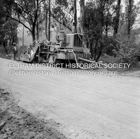
Stabilising just below Metery RoadRecord of various Shire of Eltham infrastructure works undertaken during the period of 1952-1962 involving bridge and road reconstruction projects, sometimes with Eltham Shire Council Project Reference numbers quoted. It was during this period that a number of significant improvements were made to roads and new bridges constructed within the shire that remain in place as of present day (2022). In many situations, the photos provide a tangible visible record of infrastructure that existed throughout the early days of the Shire. The album was put together by or under the direction of the Shire Engineer, J.A. McDonald.infrastructure, shire of eltham, 1958-05, footpaths and gutters, mount pleasant road, road construction -
 Kadimah Jewish Cultural Centre and National Library
Journal, Kadimah Jewish Cultural Centre and National Library, Melbourner Bleter / Melbourne Chronicle June/July 1981, ADD DATE
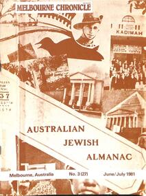
Journal published by the Kadimah Jewish Cultural Centre and National Library, Melbourne. Contains essays, reviews, fiction and poetry in both English and Yiddish.100 pages, A4, Softbound, Paper covers. non-fictionJournal published by the Kadimah Jewish Cultural Centre and National Library, Melbourne. Contains essays, reviews, fiction and poetry in both English and Yiddish.moshe ajzenbud, serge liberman, susan ivany, shirley thomas, felix rosenbloom, michael small, lysbeth cohen, judith rodriquez, yvonne fein, roslyn kopel gross, mal morgan -
 Kew Historical Society Inc
Map, Osboldstone & Co Pty Ltd, Railway and Tramway Map of Melbourne and Suburbs With Tram Timetables, 1917
The Railway and Tramway Map of Melbourne and Suburbs With Tram Timetables lists existing Cable Tram Services before the entire network was electrified. By 1917 the tramways system was divided into regions including: the Melbourne Cable Tram Service; Prahran - Malvern Electric Trams; Hawthorn Electric Trams; Melbourne, Brunswick and Coburg Electric Trams; and Brighton Beach Electric Trams. The old Outer Circle railway line is marked as ending in Deepdene, with the remainder of the line to Fairfield marked as 'Unused'. The Kew tram along High Street in 1917 ended at the Harp Junction. The Kew Spur Line is also marked on the map.The Railway and Tramway Map of Melbourne and Suburbs With Tram Timetables is historically significant as it captures at a point in time, 1917, the development of public transport infrastructure in Melbourne. As such it illustrrates the theme: Connecting Victorians by transport and communications.Printed card-covered pocket sized map that folds out with three horizontal and vertical folds. Colour map, with scale, of the rail and tram networks on one side and sixteen sections of black and white printed text and timetable information on the reverse.railway maps -- melbourne (vic.), tramways maps -- melbourne (vic.), public transport -- melbourne (vic.) -- 1910-1920, cartography -
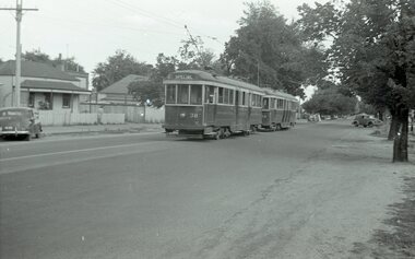
 Ballarat Tramway Museum
Negative - Black and white print from negative, Travis Jeffrey, 23/02/1962 12:00:00 AM
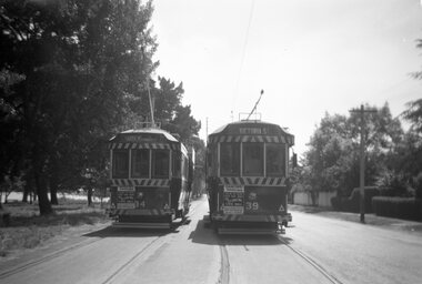
Negative No. N388 and black and white print made by a laser printer (stored in folder) of Ballarat trams Numbers 34 and 39 crossing at the loop near the depot in Wendouree Parade, Depot Loop or Tramsheds loop. Both trams have advertisements on the dash panels advising the 60/40 dancing at Civic Hall on Saturday nights. Tram 34 has destination of Gardens via Drummond St Nth, while 39 has destination of Victoria St. Date of photo on folder - 23/2/1962. Original negative rescanned 24/5/2020 and image file updated. Paper folder that contained the negative had "NR60A" in red ink, "BA16" in pencil, date stamp of "23 Feb 1962" on front, and on rear date stamps "26 Sep 1962" and "6 Oct 1962".trams, tramways, wendouree parade, depot loop, tramsheds loop, tram 34 tram 39 -
 Bendigo Military Museum
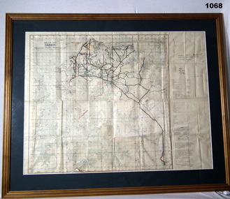
Map - DAEWIN MAP, FRAMED, 1938
Wooden frame with green border & glass front.Sketch Map of Darwin.documents - maps, frame accessories, darwin -
 Bendigo Historical Society Inc.
Map - PETER ELLIS COLLECTION: MAP AREA AROUND MITIAMO
Copy of a hand drawn map of an area near Mitiamo with various plants/trees, features and Aboriginal Water Holes drawn in. Also a smaller copy of the top part and two smaller copies of the lower half of the map.map, victoria, rushworth/whroo, peter ellis collection, mitiamo area, aborigine water holes -
 Bendigo Military Museum
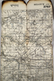
Map - TRENCH MAP WW1, 1917
Area covers from “Angre to Villers across the top, Louvignies to Wattignies across the bottom, the river Sambre runs through the bottom section” Item re William Alexander No 502 AIF. Refer Cat No 3746.3 for his service details. Map, Belgium and part of France, sheet 51, scale 1:40,000, Ordnance survey October 1917.map, belgium, trench -
 Peterborough History Group
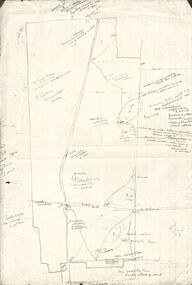
Map - Map of Peterborough House 1921, 1921
This hand drawn map of the buildings and out buildings was done for insurance purposes. It indicates which buildings are covered and which are uninsured. Significant as it shows a plan of the hotel as it was in 1921. Each building is labelled by its purpose, which provides an interesting insight into holidays of the time. For example, 'sleep outs' and external bathrooms. A4 photocopy of a hand drawn map of the buildings and out buildings comprising Peterborough House. Hand drawn map -
 Ballarat Tramway Museum
Negative, Wal Jack, early 1950's
Yields information about tram services possibly for a special event.Negative and Digital images of the Wal Jack Ballarat Negative file of trams 38 and 39 in Drummond St North, at Duncan St. Tram 38 showing Special. May be related to the Reg Item 7724.trams, tramways, drummond st nth, tram 38 tram 39 -
 Vision Australia
Negative - Image, 1984 Carols by Candlelight performers and audience
Images taken of performers at the 1984 Carols by Candlelight performance, including Joan McInnes, Patrick McMahon, Humphrey B Bear, Polyphony and The Shirt Tales. Photograph of negatives taken at Carols by Candlelight 1985 performerscarols by candlelight, joan mcinnes, patrick mcmahon, humphrey b bear, polyphony, the shirt tales -
Whitehorse Historical Society Inc.
Journal - Committee Minutes, NHS Minutes
Legal documented minutes of the Nunawading/Whitehorse Historical SocietyCommittee minutes of Historical SocietyThese are the minutes of the Nunawading Historical Society committee meetings held in 1993committee actions and decisions, minutes -
Glen Eira Historical Society
Map - Brighton Cemetery, North Road, Caulfield South
Photocopy of a typed letter from the National Trust (Victoria), dated 23/10/1997, to Brighton Cemetery Trust, notifying of the classification o the cemetery in the National Trust Register. An undated photocopy of a map and plan of Brighton Cemetery.brighton cemetery, north road, caulfield south, burke chris, brighton cemetery trust, sheffield road, hawthorn road, cemeteries, grave yards -
 Eltham District Historical Society Inc
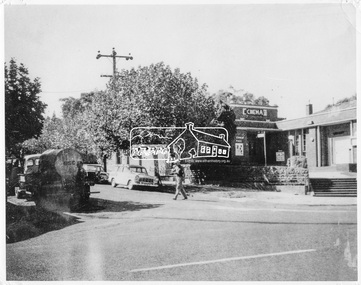
Negative - Photograph, Ian McDonald, Corner of Main Road and Arthur Street, Eltham, 4 Jan. 1968
The intersection of Arthur Street and Main Road Eltham, January 4, 1968. The Eltham Shire Council hall and offices on the right hand side. The Hall was also a cinema and operated as the Plaza Theatre from 1943 to about 1968. A truck with a water tank is on the left of the street, possibly cleaning the street. Note Cinema sign on hall. Copied from an original document produced by Ian McDonald (Eltham Shire Council) 1970. During the period 1969-1971 photos were being collected for a proposed publication on the history of the Shire of Eltham as part of its centenary celebrations in 1971 (managed by the Shire of Eltham Historical Society and Alan Marshall). The publication was Pioneers & Painters (1971), edited by Alan Marshall. The document titled "Shows area sold to Woolworths" consisted of a panorama of three B&W photo prints creating a panorama of the frontage along Main Road (SEPP_0744) and a single B&W photo print of the Shire of Eltham offices and Hall on the corner of Arthur Street and Main Road (SEPP_0737) along with typed and hand written notes by Ian McDonald. The panorama (SEPP_0744) was captioned in typewritten text "Old Shire Office and Hall, etc - Frontage of 285 feet along Main Road" and in pencil the date "4-1-68" The single image of the shire offices (SEPP_0737) was captioned in typewritten text "Main Road and Arthur Street Corner" In addition, the following handwritten notes in pencil: " I took these photos from the new fire station - the building in the middle is the old fire station - Moved to Research for the Scouts 1970" and signed "IMcD"This photo forms part of a collection of photographs gathered by the Shire of Eltham for their centenary project book,"Pioneers and Painters: 100 years of the Shire of Eltham" by Alan Marshall (1971). The collection of over 500 images is held in partnership between Eltham District Historical Society and Yarra Plenty Regional Library (Eltham Library) and is now formally known as 'The Shire of Eltham Pioneers Photograph Collection.' It is significant in being the first community sourced collection representing the places and people of the Shire's first one hundred years.Digital image 4 x 5 inch B&W Negsepp, shire of eltham pioneers photograph collection, eltham, arthur street, cinema, eltham hall, main road, shire hall, motion picture theartre, plaza theatre -
 Falls Creek Historical Society
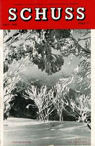
Journal - Schuss Vol. 21. No. 3 May 1955
Schuss was advertised as Victoria’s Official Ski Journal It was issued monthly from 1935 to 1961 except during the war when summer issues covered two months. This continued after the war, but it averaged 10 issues annually over its 25 year life. Schuss was published by the Ski Club of Victoria which had a membership of 38 Ski Clubs and demanded to be recognised as the prime authority on skiing in the state. The other 30 ski clubs with 85% of the members disagreed and the politics of skiing became heated. These clubs formed the Federation of Victorian Ski Clubs with their own journal, Ski Horizon. With the establishment of the Victorian Ski Association, Ski-Horizon published its last issue in Nov - Dec. 1955 and the role of the official journal was fully taken over by “Schuss”. This item is significant because it contains stories, images and information documenting the development of the ski industry in Victoria.The journal features stories and events chronicling developments in Victoria and internationally. Items related to the Falls Creek Area in this issue include:- Page 83 - Skyline Lodge is ready for the winter after extensive work has been carried out during the summer. Improvements have been made to the lounge, bathroom and kitchen and the porch floor has been resurfaced. Potential visitors were reminded of the care and attention which were necessary to ensure comfort at the Lodge is maintained. Page 87 - Photo by S. Flattely of Easter work party of S.C.V. members enjoying a meal in the newly renovated lounge room of the Skyline Lodge, Falls Creek.schuss journal, the ski club of victoria, skyline lodge -
Port Melbourne Historical & Preservation Society
Archive - Alan Mathews and family, 12 Sep 1950
The Mathews family have been in continuous ownership of 395 Howe Parade (was 8 Howe Parade until 1964 when addresses re-assigned), Port Melbourne from 1938 to the present (Sept 2019)Six folders of assorted documents relating to the life of Alan Mathews and his family. Employment documents Apprenticeship Commission of Victoria. Certificate of Proficiency Jobbing and Moulding & Core making. Alan Mathews completion 13/6/1949education - other, alan mathews -
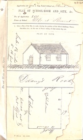 Whitehorse Historical Society Inc.
Map, Mt Pleasant School Plan, 1860
Plan of proposed school and site (Mount Pleasant School)education, mount pleasant school, no. 1022, delaney's road, vermont, non-vested schools -
Stawell Historical Society Inc
Archive - CD/DVD, Stawell Deaths & Buriels 1986-2009
stawell -
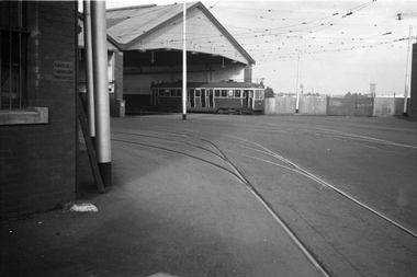 Melbourne Tram Museum
Negative, Wal Jack collection, 24/11/1941 12:00:00 AM
Black and white negative by Wal Jack of Maximum Traction N 123 at the Coburg Tram Depot. Note the sign on the wall "Hawking Canvassing Prohibited" Photo dated, 24/11/1941 in the Wal Jack album. See also Reg Item 5329 to 5332 for other photos featuring this tram.trams, tramways, n class, coburg depot, coburg, tram 123 -
 Kew Historical Society Inc
Map, Robert Russell, Map Shewing the Site of Melbourne and the Position of the Huts & Buildings Previous to the Foundation of the Township by Sir Richard Bourke in 1837
Map shows the first layout of Melbourne by Government surveyor Robert Russell, who accompanied Governor Richard Bourke in 1837. The surveyed blocks extend from present-day Flinders Street to Lonsdale Street, and Spring Street to Spencer Street, with extensive vacant land west to a salt lake (afterwards Batman's Swamp, later drained), north beyond Flagstaff Hill and south towards South Melbourne. Vegetation coverage is indicated, and tracks and existing buildings and cultivated land are shown.Printed map was created by Day & Haghe, Lithographers to the Queen, sometime after 1838, when the company received its Royal appointment. Copies of the 1837 map exist in several major map collections in Australia; most are uncoloured. This particular map is the earliest in the Kew Historical Society's map collection. It is a nationally significant artefact. Black and white lithographed map hand-coloured in blue and yellow gouache of the town of Melbourne in 1837. In contrast to the original lithograph, the river and the township blocks are coloured blue and yellow. A similar, partly coloured copy is in the collection of the University of Melbourne.maps - melbourne - 1830s, governor sir richard bourke, robert russell - surveyor, cartography -
Stawell Historical Society Inc
Archive, Stawell & District Horticultural Society, 3/12/1917 - 15/2/1927
Contains meeting details to form and continue Horticultural Society in Stawellstawell, agriculture -
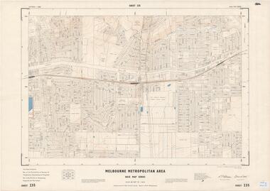 Ringwood and District Historical Society
Map - Melbourne Metropolitan Area Base Map Series, Sheet 235 - Ringwood area, 1960
Map prepared by Dept of Lands and Survey and MMBW from State Aerial Survey June 1957 and Cadastral Survey information August 1960. This sheet comprises parts of Municipalities of Doncaster & Templestowe, Nunawading and Ringwood, and Parishes of Nunawading, Ringwood and Warrandyte.Scale: 400 feet to 1 inch. Contours at 5 feet vertical interval. By Authority: A.C. Brooks, Commonwealth Printer, Melbourne. -
Stawell Historical Society Inc
Archive - Book, Registration Of Residence Sites 3/1/1871 - 17/8/1882, 1871
Residence Area Miners Right Mining used by Stawell ShireVery Large Brown Leather Ledger with marbling on inside cover. Red Label on Spine Registration Booklocal government, miners right -
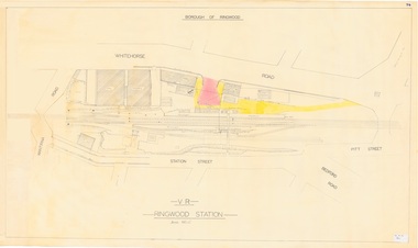 Ringwood and District Historical Society
Plan, Borough of Ringwood - VR Ringwood Station - Circa 1930s
Technical drawing of Ringwood Railway Station features, surrounding streets and buildings including Cool Stores, Packing Shed, Coke Bin, Coal Box, Dam, Garage, Shops, ES&A Bank, Station Master's Residence, Drill Hall, Goods Shed, Signal Box, Passenger Platform, Footbridge, and Clock Tower at Warrandyte Road. Station entrance and traffic access areas shaded red and yellow.Scale: 1"=40' -
Stawell Historical Society Inc
Archive, Matthew Dalkin and Sons Produce Merchants Grocers Main Street Stawell Journal, 1870 - 1883
Folio Sized Leather Bound. Marbled End PapersHand Writtenstawell, business -
University of Melbourne, Burnley Campus Archives
Journal, New York Botanical Garden, The Botanical Review; interpreting botanical progress, 1958
Publ. New York Botanical Garden, Vol. XXIV, No.1, Jan. 1958new york botanical garden -
Whitehorse Historical Society Inc.
Journal - Document, Nunawading and District Historical Society newsletters
Nunawading and District Historical Society newsletters - 1972-1980A set of Nunawading and District Historical Society Newsletters.non-fictionNunawading and District Historical Society newsletters - 1972-1980newsletters history, history