-
 Melton City Libraries
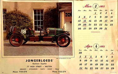
Archive, Jongebloed's Hardware Supplies Calendar, 1972
Bakery Square was the site of 19thCentury Jongebloed family bakery, grocery shops and residence demolished 1970 and later hardware shop erected c 1960. Stables at rear to McKenzie StreetCalendar from the hardware storelocal identities -
 Stawell Historical Society Inc
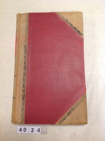
Archive, Stawell Hospital Records Journal, 1975 – 1980, 31/8/1975 - 30/6/1980
Red Covered with leather trimJournal 4394stawell -
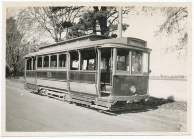 Ballarat Tramway Museum
Negative - Set of 2, Wal Jack, 2/06/1935 12:00:00 AM
.1 Negative of a black and white photograph of Ballarat No. 28 near the SEC depot in Wendouree Parade, has Lake in the background. Tram in the ESCo colour scheme of Red and Cream/yellow - shows high bumper and small door and single step that was provided on opposite corners. Photo 2-6-1935. Alan Bradley advised in an e-mail 27/9/2006 that According to the rolling stock cards No. 28 was altered to the final one-man style and re-painted from red to green on 12/3/1938, the last Ballarat car to be so treated. 3566.2 - Digital image from the Wal Jack Ballarat Album of the same photograph as 3566.1 Rear of photo, image i2, dates the image as 2.6.1935. Image btm3566i3.jpg made from negative (N705) from within Wal Jack papers ex Keith Kings - (3200dpi - 19MB) scan - added 19/7/2019. Record Revised to updated for better images etc. 19/7/2019. See image i2 for rear of photograph. See image i3 for hi res scan of print. See image i4 for hi res scan of negative. On rear of .1 in ink "SEC Ballarat 5241, "No. 28 (read and cream) altered with steps at opposite corners only. Wendouree Parade 2.6.35" and has the number T5, within the Wal Jack stamp.trams, tramways, sec, esco, livery, colour schemes, tram 28 -
 Stawell Historical Society Inc
Map, MPI Mines, Plan View of Township Area 2003, 13/6/2003
goldShowing known gold workings & Houses Stawell Gold Mines. 13 June 2003 1 : 7500 MPI Minesmining -
Stawell Historical Society Inc
Map, Stawell Gold Mines, Stawell Township proposed Town zoning showing Special Uses ( Mining) 1998, 1998
Shows Mining activity Stockpiles Tracks, Plant, Dams, Waste heap, Tailing Dams, IronbarksMap Printed in Colour with Coloured LegendStawell Gold Mines Pty Ltd Date April 1998mining -
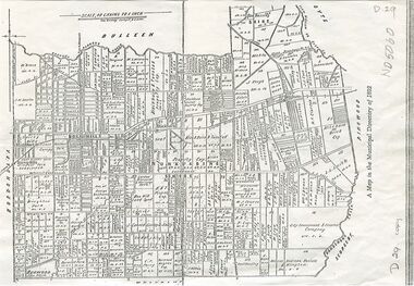 Whitehorse Historical Society Inc.
Map, Shire of Nunawading, 1892
Map of the Shire of Nunawading in the Municipal Directory of 1892e of NunawadingPhotocopy of a map of the Shirew of Nunawading in the Municipal Directory of 1892 showing land owners.Map of the Shire of Nunawading in the Municipal Directory of 1892e of Nunawadingmaps, shire of nunawading -
Glenelg Shire Council Cultural Collection
Archive - K. S. Anderson Collection, 27/04/1986
K.S. Anderson Collectiona) 3 Page handwritten letter on lined paper from Pat Hughes to K.S. Anderson. b) March/April 1986 copy of 'Victorian Ports Log', 8 page Newsletter published for Victoria's port workers.k s anderson, documents, archive -
Bendigo Historical Society Inc.
Map - PARISH OF CAMPASPE, November 1880
Map: Parish of Campaspe, County of Rodney. Parish plan G.H.H. Smith Draughtsman August 1880 Examined J.A. Morrison 7.10.80 Photo- Lithographed J. Noone. 1.11.80 Written in green " Cancelled 16.2.66."map, rodney, parish plan, campaspe -
Stawell Historical Society Inc
Archive - Book, Stawell Shire, Registration Of Residence Sites / Areas 23-4-1890 - 6-2-1900, 1900
Residence Area Miners Rightused by Stawell ShireLarge Light Brown Leather Ledger Red Spine and CornersRegister of Residence Areas & Crown local government, miners right -
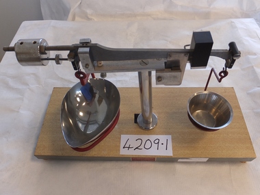 Stawell Historical Society Inc
Archive, Two sets of Scales (Pharmacy) Pleasant Creek Training Centre
stawell -
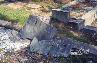 Eltham District Historical Society Inc
Negative - Photograph, Harry Gilham, Grave of Richard George, Emily Ann (nee Davis) and Edith Jane Kaylock, Eltham Cemetery, Victoria, Sep 2009
In his early adult life, Richard Kaylock worked as a whaler (visiting California and New Zealand) and later as a drover on a large cattle station in New South Wales. In 1848 he came to Melbourne, working as a slaughterman, then settled in Eltham in 1854, his occupation thereafter being variously recorded as butcher or orchardist. He also had some experiences at Ballarat during the Eureka Rebellion. He died in 1910 at the age of 84. His obituary described him as a "striking personality" who was "brusque to a fault" and "strictly upright, expecting others to be the same". It seems from his will that he was illiterate. He is buried in Eltham Cemetery with his wife Emily. His property was in Wellington Street (now Brougham Street) and apparently extended across the Diamond Creek. The land on the western side of the creek was farmed, the house being on the eastern side. For many years the Brougham Street bridge was generally known as "Kaylock's Bridge". It formed part of the original coach road to Eltham and in 1922 was described as an "old rustic bridge". Its low level and insubstantial construction made it susceptible to flood damage, necessitating frequent closures until repairs could be carried out. The original bridge was demolished in 1923 and replaced by a "new up-to-date" one. When a lack of finances delayed repairs to the Bridge Street bridge in 1931, traffic had to detour via Brougham Street for some time. Local residents feared that the Bridge Street bridge might never reopen. In Loving Memory Of Our Dear Father & Mother R.G. and E.A. Kaylock Also E.J. Kaylock Died 21st Jan. 1927 The Eternal God Is My PledgeRoll of 35mm colour negative film, 6 stripsKodak GC 400-9eltham cemetery, gravestones, edith jane kaylock, emily ann kaylock (nee davis), richard george kaylock, brougham street bridge, kaylocks bridge -
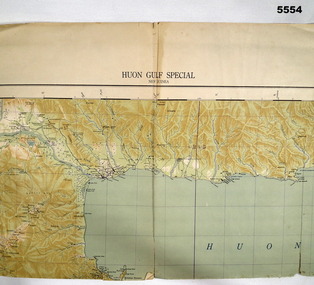 Bendigo Military Museum
Map - MAP, HUON GULF AREA, Aust Survey Corps et al, Aug 43
Refer Cat 5547 - Matheson.This is a single sided map, printed in colour. Scale 1:253,440, 4 miles to an inch, grid squares are 10mm x 10mm. Top right side shows Finschafen. Top centre is Lae, Middle is Salamau. Bottom is Lasanga Island. Top left vicinity is Nadzab and Markham River.There are four "corner" marks in pencil. Two on land and two out in the gulf.ww2, new guinea, map -
Stawell Historical Society Inc
Archive - Record cards, Employee History Cards
Employee History from Norwellen now closed. Surname Christian Name Address Date of Birth Sex M.S Dependents Date Commenced Salary Commenced Alteration Occupation Department War Service Employment Ceased Reason Remarks Reverse Annual Holiday Records Sick Pay Qualifying PeriodCardEmployee History card Norman Bros. Pty. Ltd. No: 5836. Anorwellen -
Stawell Historical Society Inc
Archive, Stawell Woollen Mills . Folien Kolorimeter Indicator
Small Black Casestawell, industry -
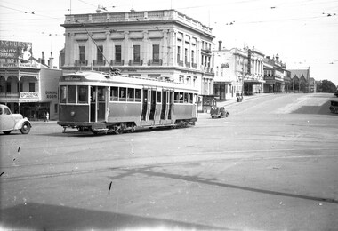 Ballarat Tramway Museum
Negative, Wal Jack, 16/12/1945 12:00:00 AM
Yields information about the appearance of the ex Melbourne bogie trams, in the interim before the renumbering of the tram was completed.Negative and Digital image of the Wal Jack Ballarat Negative file of at new bogie tram to Ballarat, turning from Lydiard St North into Sturt St, with the destination of Gardens via Drummond North. Most likely No. 22, based on Reg Item 5273 - 16/12/1945 Has the Commonwealth Bank, Beacham's Unicorn Hotel, A. J. Rowland Estate Agent, Hagers Cafe?, Her Majesty's Theatre, The Ballarat Wattle, the newsagent kiosk and at the time, the Methodist Church of Ballarat. trams, tramways, lydiard st, sturt st, new tramcars, bogie trams, tram 22 -
Stawell Historical Society Inc
Archive - CD/DVD, Tasmanian Convicts Database Index
stawell -
Stawell Historical Society Inc
Map - Subdivision map, Subdivision of Woodlands Estate Map
Shows Homestead Cottage and Dam, Plus Shed. Malakoff NavarreA3 photocopy of MapParishes of Malakoff and Navarre. County of Kara karasurvey -
Stawell Historical Society Inc
Archive - Ledger, Valuation of Plant & Machinery No. 3 1948-1949, 1948
Brown Cover held by 1 Stud and Bull dog clip.Valuation of Plant & machinery at North Western Woollen Mill Stawell No. 3 -
Bendigo Historical Society Inc.
Map - SALISBURY WEST, 29/01/1878
Map: Salisbury West, County of Gladstone. Parish plan (number 305 in map cupboard 1)map, gladstone, parish plan, salisbury west -
Kew Historical Society Inc
Archive (Sub-series) - Subject File, FENWICK, Nicholas A, 1958
Various partiesReference, Research, InformationSecondary Values (KHS Imposed Order)Small subject file with a single copy of ‘Despatches to the Governor of New South Wales A1278’, notifying that Nicholas Fenwick is being sent to New South Wales to fill the role of Police Magistrate. The other item is a typed version of the advertisement for the Crown Lands Sale in Kew in 1851.kew (vic) - history, kew (vic) - crown land sales, nicholas a fenwick, early landowners - kew (vic.)kew (vic) - history, kew (vic) - crown land sales, nicholas a fenwick, early landowners - kew (vic.) -
Stawell Historical Society Inc
Archive, Pleasant Creek Cemetery Minutes Book- Typed Copy, 1890 - 1958
Minutes of meetings and correspondence.stawell -
Bendigo Historical Society Inc.
Map - MANDURANG 2, March 194-?
Map: Mandurang 2, County of Bendigo. Parish plan (number 296 in map cupboard 1)map, bendigo, parish plan, mandurang -
Stawell Historical Society Inc
Archive - Labratory Book, Statistics
Dye Laboratory Norwellan / Aunde now Clsoed 1: Facts and Figures by M.J. Moroney - John T Bennett Lydon Hall Leeds 2 8/10/69 2: Knotts Matematical Tables 3: Systematic Semi Micro Qualitative Analysis Tabels - John T Bennett Lydon Hall Leeds 2 4: Cambridge Elementarty Statistical Tables 5: Matriculation Trigonometry - John T Bennett Lyddon Hall Laeeds 2 6: Calculations in Yarns and Fabrics North Western Woolen Mills became Norwellan Textiles then AUNDEJohn T. Bennett Lyddon Hall Leeds 2x2 Date 1norwelan, john bennett -
 City of Kingston
Negative - 35mm, black and white, Percy Fairlam, c. 1910
Image 1a and 1b - Church of Christ, located in Chesterville Road, Cheltenham. Images 2a and 2b - Pioneer Presbyterian Church, Scots Church, located in Charman Road, Cheltenham Images 3a and 3b - Shopping strip located on Charman Road, Cheltenham, c.1918 Images 4a and 4b - A cricket team, located in Cheltenham Images 5a and 5b - Cheltenham Cricket Team, photographed outside St Matthew's Church. Back row: E. McSwain, R. Woff, S. Cullen, F. Bodley, T. Chandler, C. Warne, A. Organ, J Monk. Middle Row: C. Roberts, A. Hewett, S. Chandler, F. Chandler, A. Chandler. Front Row: A. Beulke, F. Groves Images 6a and 6b - Cheltenham Rifle Club Committee Opening Day of the new Butts. Back row: C Irwin, E. W. Proudman (Chemist), F T LePage, Centre: W Lamb Smith (Captain), E T Penny, G. Stayner, One unknown gentleman, Front: John Butler, city inspector, and E C Rippon (Manager of the Cheltenham and District Co-operative). A strip of 35mm black and white negative film of six photographs. rifle club, cricket, cheltenham cricket club, charman rd, church, cricket club, shopping strip, horse, cow, sport, team, cars -
Port Melbourne Historical & Preservation Society
Archive - Alan Mathews and family
The Mathews family have been in continuous ownership of 395 Howe Parade (was 8 Howe Parade until 1964 when addresses re-assigned), Port Melbourne from 1938 to the present (Sept 2019)Six folders of assorted documents relating to the life of Alan Mathews and his family. Collected items, paper notes, drawings from Alan's childhood. Newspaper cutting of a cartoonnewspapers, alan mathews -
 Bendigo Historical Society Inc.
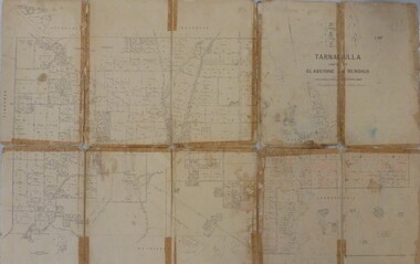
Map - JACK FLYNN MAP COLLECTION: GLADSTONE AND BENDIGO - TARNAGULLA, 13th May 1922
Map 388. Counties of Gladstone and Bendigo a Map of Tarnagulla with Kingower, Glenalbyn, Inglewood, Waanyarra and Laanecoorie boarding. The map is in poor condition and in several pieces. It has been previously taped together. The front page is of red card with white tape along the spine to hold it together, top half Tarnagulla is hand written in black lead on a label with blue trim.By Authority A.J. Mullett, Government Printer, Melbourne. Photo-Lithographed at the Department of Lands and Survey, Melbourne by W.J. Butson. 13.5.22map, bendigo, tarnagulla, tarnagulla, kingower, glenalbyn, laanecoorie, inglewood. -
 Bendigo Military Museum
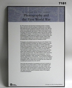
Literary work - STORY BOARD - FRAMED - WW1, Bendigo & District RSL Sub Branch et al, c2008/09
Refer Cat No. 1280.Story board - framed. Story Board - black print on white and pale blue background on synthetic paper adhered to backing board. Frame - metal with wood backing board."A CAMERA ON THE SOMME" "Photography and the FIRST WORLD WAR"framed accessories, camera on the somme, ww1, 38th bn, grinton, photography -
Moorabbin Air Museum
Archive (Item) - Box Baa 91 Boeing (Gaf / Asta) Collection
Description: - JINDIVIK DRAWINGS B4A-H82-005 TO -H84-061 Level of Importance: National. Historical Details: DAP/GAF/ASTA constructed many overseas designs under licence in Australia (Beaufort, Beaufighter, Lincoln, Canberra and F18) however they also designed and constructed a number of significant local designs that were successful in oversea's markets includi -
 Melbourne Tram Museum
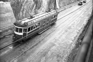
Negative, Wal Jack, c1942
Black and white negative, by Wal Jack, of W2 636 (City route 42) in the Barkers Road cutting on a wet day. In front of the tram appears to be two cars with trailers. Photo not dated in the Wal Jack album. Possibly 14-9-42 based on other similar photos.trams, tramways, barkers road, w2 class, route 42, tram 636 -
Bendigo Historical Society Inc.
Map - PANNOOMILLOO, 21/06/1882
Map: Pannoomilloo, County of Bendigo. Parish plan (number 282 in map cupboard 1)map, bendigo, parish plan, pannoomilloo