-
 Vision Australia
Plan - Image, Vision Australia Kensington plans, 2009
Diagrams of seating and layout for the opening of Vision Australia's office in Macaulay Road, Kensington in 2009.Digital files of Macaulay office fit outvision australia, plans -
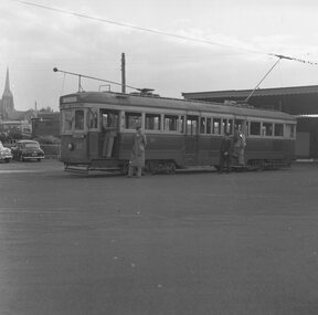
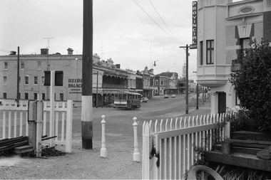 Ballarat Tramway Museum
Negative - Set of 2, Campbell Duncan, 28/02/1971 12:00:00 AM
Yields information about tram operations and the street views at the Ballarat Station area and Lydiard St North.Set of 2 photographs taken on 28/2/1971 by Campbell Duncan of trams at the Ballarat Station level crossing, Lydiard St North.\ .1 - tram - inbound - after with Reid's Palace and the Provincial Hotel in the background. .2 - No. 30 outbound to Lydiard St North with the Ballarat B signal box and the Provincial Hotel in the background. Tram has Bliss bombs tilt tram to read pack advert.trams, tramways, lydiard st north, railway station, level crossings, signals, tram 30 -
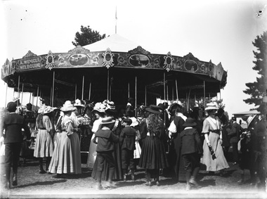 Wodonga & District Historical Society Inc
Negative - Haeusler Glass Negatives Collection - Merry-go-round - A. Weniger's Steam Carousel, c1910
This digital image was produced from one of the glass negatives that form part of the collection, probably taken by Louis Haeusler (b.1887) with the photographic equipment in the Wodonga Historical Society Haeusler Collection. Merry-Go-Rounds or Carousels were a popular entertainment accompanying many celebrations and events in Albury and Wodonga from as early as the mid 1870s. They featured at events such as Empire Day and Arbor Day celebrations as well as the Wodonga Racing Club meetings, Wodonga Agricultural Shows and Victory Day celebrations at the end of World War 11. They were operated by a variety of travelling showmen and entrepreneurs. Early merry-go-rounds were steam powered. The merry-go-round in this negative was owned by Anton Weniger of Melbourne. From 1909, Mr Weniger operated a shooting gallery and Steam Riding Gallery on the Lower Esplanade, St. Kilda on land he had leased in 1909 from the St. Kilda Foreshore Trust. Weniger also took his carousels by train to many rural areas, including several visits to Albury, Yarrawonga and Benalla. His largest carousel was designed and built in Melbourne by Herbert Thomson in 1915. It has now been restored and has been on show as the Civic Carousel in Canberra, ACT since 1974. Anton Weniger’s steam merry-go-round was definitely in the Albury- Wodonga area in September 1912. As reported in the Border Morning Mail on Saturday 2 November 1912, Mr. Weniger was the victim of a robbery which included some money and his gold watch and chain, stolen from a railway truck in the Wodonga railway yards. The riding gallery and other belongings had been placed on the truck in Albury after the Albury show and sent on to Wodonga in transit to Wangaratta. Whilst in the Wodonga yards the truck was broken into and the goods stolen. Two of Weniger’s former employees, Herbert Backhouse and Edmund Pressard were subsequently charged with the robbery and sentenced to respective sentences of 3 and 9 months imprisonment, both with hard labour. In January 1916, Weniger’s Steam Riding Gallery was attacked by a group of rioting soldiers as a result of rising anti-German sentiment with the onset of World War 1. As a result, Anton Weniger terminated his interest and lease of the Steam Riding Gallery to his partner, William George Kelly. Although he had lived in Victoria for over 25 years and had been a naturalised Australian for 20 years, Anton Weniger was interned for the duration of World War 1 as an enemy alien. Anton Johannes Matthias Weniger died on 14 August 1923 and is buried in the Brighton General Cemetery, Melbourne, Victoria.This item is unique and has well documented provenance and a known owner. It forms part of a significant and representative historical collection which reflects the local history of Wodonga. It contributes to our understanding of domestic and family life in early twentieth century Wodonga, as well as providing interpretative capacity for themes including local history and social history.Digital image created from the Haeusler Glass negative collection. A large group of people standing around a Merry-Go-Round.At top left of Merry-Go-Round "A.WENIGER./MELBOURNE"wodonga pioneers, haeusler family, glass negatives, dry plate photography, carousel, anton weniger -
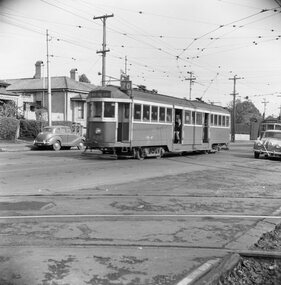 Ballarat Tramway Museum
Negative, Geoff Grant, 7/05/1955 12:00:00 AM
Negative No. N298 and colour print made by colour laser printer (stored in folder ) of SW2 426 outbound on route 70 past the Camberwell Depot access tracks on 7/5/1955. Photo by Geoff Grant. Negative scanned hi res and imaged updated 20/5/2020.trams, tramways, melbourne, camberwell depot, tram sw2 426 -
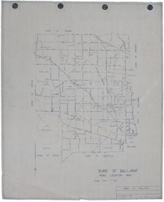 Federation University Historical Collection
Map, Shire of Ballarat Road Location Map, 1968, 05/06/2014
White paper road location map. Scale 1 mile to 1 inchballarat, shire of ballarat, roads, dowling forest, lake burumbeet, lake learmonth, ascot, windermere, tourello -
Kew Historical Society Inc
Archive (series) - Subject File, Action Groups [General], 1993
Various PartiesReference, Research, InformationKHS OrderReference file containing sundry newspaper articles and correspondence relating to action groups established to protect Victoria Park, High Street, and Willsmere-Chandler Park.mcdonald’s restaurant, skateboard park, victoria park, victoria park heritage group, willsmere-chandler parkmcdonald’s restaurant, skateboard park, victoria park, victoria park heritage group, willsmere-chandler park -
 Stawell Historical Society Inc
Archive, Stawell Hospital Records Board of Management Minutes 1940 – 1945. Book 3, 12/02/1940 - 13/02/1945
MinutesMinute Book 3stawell health medical -
Stawell Historical Society Inc
Archive, Stawell Arts Council, Minute Books, 4/5/1971 - 12/2/1975
Two Account Books with pasted in minutes of meetings from 4/5/1971 - 12/2/1975stawell, arts -
 Kew Historical Society Inc
Map, MMBW, MMBW Town of Kew, 1910-21
The Melbourne and Metropolitan Board of Works (MMBW) was established by an act of the Victorian Parliament in 1890 to prepare for and to implement a sewerage and water reticulation system across what was then inner Melbourne, its surrounding and middle distance suburbs, including Kew. The MMBW was disbanded in 1991.The map collection of the Kew Historical Society has at its core the historic maps assembled and originally stored in the City Engineer's Department of the City of Kew. These include maps in a number of scales. The vast majority of maps were produced by the MMBW in the first two decades of the twentieth century, and are solid working maps, backed by linen for durability. These maps are historically significant to Kew, the City of Boroondara and to the history of the development of state utilities in Victoria. A number of the Kew maps have additional details added by former municipal officers, including the levels reached by various floods. As these were working documents, information was added to them long after the period of their initial production and distribution.Early map of the Town of Kew, created after 1910, at a scale 440 ft to 1 inch. The 'assembled' map by the City of Kew Engineer's Department includes scaled down copies of The Melbourne and Metropolitan Board of Works maps, Nos. 39, 40, 64, 65, 66, 67, 68, and 117. The map covers the entirety of the Town of Kew, bordered on its north and west by the River Yarra, by Burke Road in the East and Barkers Road in the south. The map shows the extent of urban development by that time, prominent institutions and the outlines of built structures in the municipality. TOWN OF KEW / SCALE 400 FEET TO 1 INCHmelbourne & metropolitan board of works, mmbw maps, mmbw plans, town of kew, cartography -
Whitehorse Historical Society Inc.
Map, A Plan of part of the Parish of Nunawading, 1984
Hand drawn plan showing the owners or occupiers of land c1860'.Hand drawn plan showing the owners or occupiers of land c1860'. Includes proposed townships of New Brunswick and Norwich. Scate 1 inch : 10 chains.Hand drawn plan showing the owners or occupiers of land c1860'. maps, shire of nunawading -
Stawell Historical Society Inc
Map, Roads Maintained by NGSC. Roads Maintained by Other Authorities, C 2020
Printed Colour map of Norther Grampians Shire, with roads marked in colourNorther Grampians Shire COuncil. 1:200,000shire, roads, transport -
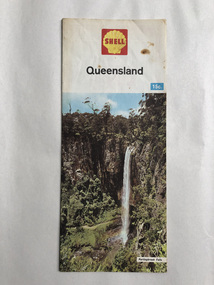 Robin Boyd Foundation
Map, Shell Touring Service, Queensland
walsh st library -
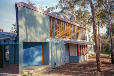
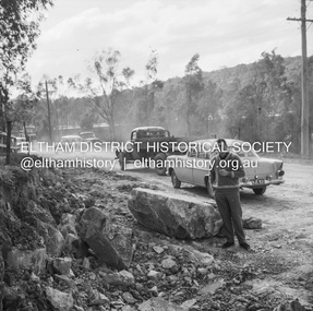 Eltham District Historical Society Inc
Negative - Photograph, J.A. McDonald, Road reconstruction works, unidentified location, Shire of Eltham, c. July 1962
Record of various Shire of Eltham infrastructure works undertaken during the period of 1952-1962 involving bridge and road reconstruction projects, sometimes with Eltham Shire Council Project Reference numbers quoted. It was during this period that a number of significant improvements were made to roads and new bridges constructed within the shire that remain in place as of present day (2022). In many situations, the photos provide a tangible visible record of infrastructure that existed throughout the early days of the Shire. The album was put together by or under the direction of the Shire Engineer, J.A. McDonald.1962-07, infrastructure, reconstruction works, road construction, shire of eltham, unidentified -
Moorabbin Air Museum
Archive (Item) - Box Baa 97 Boeing (Gaf / Asta) Collection
Description: - JINDIVIK DRAWINGS B3B-20-03/04 TO B3B-20-180 Level of Importance: National. Historical Details: DAP/GAF/ASTA constructed many overseas designs under licence in Australia (Beaufort, Beaufighter, Lincoln, Canberra and F18) however they also designed and constructed a number of significant local designs that were successful in oversea's markets includi -
Moorabbin Air Museum
Plan (item) - Bristol Aeroplane 170 schematic drawings, Unable to determine due to condition of document
Bristol Aeroplane Company Ltd -
 Kew Historical Society Inc
Plan, Melbourne & Metropolitan Board of Works : Borough of Kew : Detail Plan No.1574, 1905
The Melbourne and Metropolitan Board of Works (MMBW) plans were produced from the 1890s to the 1950s. They were crucial to the design and development of Melbourne's sewerage and drainage system. The plans, at a scale of 40 feet to 1 inch (1:480), provide a detailed historical record of Melbourne streetscapes and environmental features. Each plan covers one or two street blocks (roughly six streets), showing details of buildings, including garden layouts and ownership boundaries, and features such as laneways, drains, bridges, parks, municipal boundaries and other prominent landmarks as they existed at the time each plan was produced. (Source: State Library of Victoria)This plan forms part of a large group of MMBW plans and maps that was donated to the Society by the Mr Poulter, City Engineer of the City of Kew in 1989. Within this collection, thirty-five hand-coloured plans, backed with linen, are of statewide significance as they include annotations that provide details of construction materials used in buildings in the first decade of the 20th century as well as additional information about land ownership and usage. The copies in the Public Record Office Victoria and the State Library of Victoria are monochrome versions which do not denote building materials so that the maps in this collection are invaluable and unique tools for researchers and heritage consultants. A number of the plans are not held in the collection of the State Library of Victoria so they have the additional attribute of rarity.Original survey plan, issued by the MMBW to a contractor with responsibility for constructing sewers in the area identified on the plan within the Borough of Kew. The plan was at some stage hand-coloured, possibly by the contractor, but more likely by officers working in the Engineering Department of the Borough and later Town, then City of Kew. The hand-coloured sections of buildings on the plan were used to denote masonry or brick constructions (pink), weatherboard constructions (yellow), and public buildings (grey). This plan shows several very large houses, particularly along Glenferrie Road, and the area now occupied by Ruyton Girls’ School. ‘Tarring’ (incorrectly spelled here as ‘Karring’) was built for Henry Henty in 1872, on part of his original allotment of 20 acres, and ‘Mount View’, which retains its original building and the fountain in the front garden, is part of Ruyton’s Junior School. The most significant change to Tarring and its grounds since 1903, involve the removal of a number of the outbuildings, including a Burmese temple, bought by Henty from the Burmese Exhibit at the Great Exhibition of 1880. It is shown on the plan as a summerhouse. The two-storey mansion, on the corner of Glenferrie Road and Wellington Street, was built in 1891 by leading architect Alfred White as his own home. Having an initial N.A.V. of £160, the house was purchased by a warehouseman Henry Lister, by 1900, when the N.A.V. was recorded at £111. By the turn of the century the house was known as ‘Comaques’. By contrast, much smaller houses are shown in Scott and Byron Streets, including a tiny Mission Hall in Byron Street, which belonged to the Anglican Church from at least 1903 to 1917.melbourne and metropolitan board of works, detail plans, maps - borough of kew, mmbw 1574, cartography -
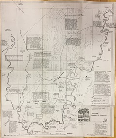 Kew Historical Society Inc
Plan, Loder & Bayly, Heidelberg: Historic River Landscape Assessment, 1982
Gwen McWilliam is well known as an authority on the history of Boroondara and the author of a large number of books and pamphlets about the City. She was awarded the medal of the Order of Australia in 2001 ‘for service to the community of Hawthorn and district, particularly through the research, documentation and publication of its history.’ This map from her collection was donated to the Kew Historical SocietyPlan of Heidelberg, annotated with details about the occupancy pre and post European settlement. The plan also contains geological references. The plan is included and analysed in volume 2 of the Heidelberg Conservation Study (1985). The original plan was published created in 1982. Printed annotationscity of heidelberg, yarra valley, historic plans -- heidelberg -
University of Melbourne, Burnley Campus Archives
Plan, Swan St. Entrance, 1988-1989
Found in file labelled, "Swan St. Entrance" Geoff Olive.(1) Correspondence between Mr Ron Hamilton, Manager, Tram Operations, Eastern Section and Steve Mullany, Lecturer. Includes plan of "Entrance to V.C.A.H. Burnley and Plant Research Institute." (2) Handwritten note dated 5 July 89. (3) Handwritten estimate of costs by Ian W(instone). (4) Photocopy of planting plan. Also see B11.0592. ron hamilton, vcah, burnley campus, steve mullany -
Moorabbin Air Museum
Map (Item) - Environs of the Top End Map
-
Beechworth Cemetery Trust
Map - Beechworth Cemetery reproduction of original map -Secretary copy, Beechworth Cemetery
Reproduction map displaying all grave sites in Beechworth Public Cemetery. Rotunda, fountain, nursery, memorial wall, pioneer sectionmap displays the plan of grave sitesLaminated Photocopy of original cemetery map with additional information hand-written on the map. All graves at the cemetery set out in denominational sections with hand-written information on additional graves added to sections in Roman Catholic A & C, Church of England A-F, Presbyterian A-C, Methodist/Uniting B and Wesleyan A. Multidenominational hand-written note on Jews section with Trust Minutes 4.7.'83 written next to this addition. Additions hand-drawn of fountain, memorial wall, nursery and pioneer cemetery.rotunda, fountain, nursery, memorial wall, pioneer section, graves, chinese section, un-numbered grave sites, cemetery -
Moorabbin Air Museum
Archive (Item) - Box Baa 109 Boeing (Gaf / Asta) Collection
Description: File: JINDIVIK FUEL TANK LEAKAGE TESTS - Investigation and Recommendations THOMPSON AIRCRAFT SUBMERGED FUEL BOOSTER PUMP Model TB-60200-6 - Technical Data, Installation and Use (2 Copies) GAF Project Note B3B/6.72 - JD 23 TRIALS INTAK Level of Importance: National. Historical Details: DAP/GAF/ASTA constructed many overseas designs under licence in Australia (Beaufort, Beaufighter, Lincoln, Canberra and F18) however they also designed and constructed a number of significant local designs that were successful in oversea's markets includi -
![Map, Public Lands Office, Township of Sandridge [cartographic material] / lithographed at the Public Lands Office, March 30th 1859, 30 March 1859](/media/collectors/4f729f5897f83e0308601603/items/63c6354eae7bf372478c58b7/item-media/63c635d4ae7bf372478c7627/item-fit-380x285.jpg) Mission to Seafarers Victoria
Mission to Seafarers VictoriaMap, Public Lands Office, Township of Sandridge [cartographic material] / lithographed at the Public Lands Office, March 30th 1859, 30 March 1859
The map shows where the land of the Customs House was and where the Bethel church was built in 1860. It also shows the name Gregory, a family of land owners who became the managers of the new building on the same site in 1889.sandridge, bethel church, customs house, gregory -
 Eltham District Historical Society Inc
Negative - Photograph, Rear of Eltham North Hall, 1998c
Roll of 35mm colour negative film, 8 strips and associated 10 x 15 cm colour printKodak Gold 100-5eltham north, eltham north hall -
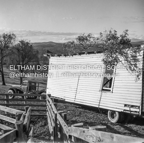 Eltham District Historical Society Inc
Negative - Photograph, J.A. McDonald, Removal of the remains of the Abraham house at Kangaroo Ground, c. May 1962
Martin Bros House Removing of Seaford was contracted to remove the remains of the storm damaged Abraham house from the property circa May 1962. The Abraham family owned land near the Aqueduct and east of Nicholas Lane at Kangaroo Ground (based on photos, at or near 40 Nicholas Lane).Record of various Shire of Eltham infrastructure works undertaken during the period of 1952-1962 involving bridge and road reconstruction projects, sometimes with Eltham Shire Council Project Reference numbers quoted. It was during this period that a number of significant improvements were made to roads and new bridges constructed within the shire that remain in place as of present day (2022). In many situations, the photos provide a tangible visible record of infrastructure that existed throughout the early days of the Shire. The album was put together by or under the direction of the Shire Engineer, J.A. McDonald.1962-05, abraham house, kangaroo ground, martin bros house removing seaford, nicholas lane, property damage -
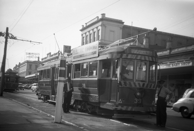 Ballarat Tramway Museum
Negative - Black and white print from negative, Travis Jeffrey, 23/02/1962 12:00:00 AM
Negative No. N389 and black and white print made by a laser printer (stored in folder) of Ballarat tram No. 39 at the City terminus, north side of Sturt St. Has tram No. 32 behind approaching the rear of No. 39. Driver or motorman standing by the front of the tram, with a passenger standing alongside the tram. No. 39 has destination of Victoria St and has a SEC Electric Cooking roof advertisement. Tram alongside the short pole tram stop. In the background is the Baby shop, the SEC offices and Tunbridge's buildings. Date of photo on folder - 23/2/1962. Original negative rescanned 24/5/2020 and image file updated. Paper folder that contained the negative had "NR61A" in red ink, "BA17" in pencil, date stamp of "23 Feb 1962" on front, and on rear date stamps "26 Sep 1962" and "6 Oct 1962".trams, tramways, sturt st, city terminus, tram 39 -
 University of Melbourne, Burnley Campus Archives
Plan, Burnley Gardens. City of Richmond. Parish of Jika Jika - County of Bourke, 1927
Part-coloured plan showing drainage, sewerage drains, taps and waterstops. Area bounded by Swan St. To N, Yarra River on E and Richmond Park on SW side. Contour lines of orchard depicted, laying pens and yards. Coloured area depicts pavilion with surrounding garden and paths layout pencilled in. Photo-Lithograph by Dept. of Lands & Survey, Melbourne by W. Butsonsewerage, drainage, lithograph, pavilion -
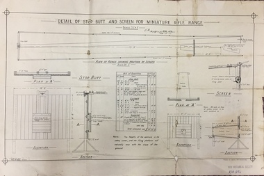 Kew Historical Society Inc
Plan, JC Brown, Detail of Step Butt and Screen for Miniature Rifle Range, 26 February 1910
On 19 July 1907, The Box Hill Reporter published an article on the Miniature Rifle Range. It stated: "Miniature Rifle Range for Kew. The Kew rifle club has made arrangements for the establishment of a miniature rifle range. The Kew borough council has provided a site in the yard at the rear of the town hall, fronting Brougham street. The site has been inspected by the military authorities, who have approved of the locality selected and the arrangements to be made to render the range absolutely safe. The plans are at present being prepared, and it is expected that the range will be completed within the next two months. The range will be under the direct control of the rifle club, subject to the supervision of a joint committee from the council and the club. The first committee will consist of Crs Wishart (mayor), Kellett, and Hiscock as representing the council, and Captain Argyle and Mr S. Abbott representing the rifle club. The range when completed will be available for the use of cadets, friendly societies, and other miniature rifle clubs in the district. Miniature rifle ranges are now occupying a great deal of attention in Great Britain, on the Continent, and in America. Lord Roberts, writing recently on the subject, remarks- "While I do not for a moment pretend that miniature rifle shooting is, in all respects, as useful as knowing how to shoot on a long range, I am satisfied that men can learn to shoot on miniature ranges, and that unless miniature ranges are very generally made use of, the greatest majority in this country will never learn to shoot at all." It is possible by this means also to divert the at present dangerous enthusiasm of uninstructed youths for the pea rifle into safer and more useful channels."Important early document identifying the specifications for a miniature rifle range in central Kew. Rifle clubs and rifle ranges were an important element in defending Victorians and Australians to outside threats. Single page plan (folded), created and approved in 1910, listing the approved specifications for a miniature rifle range in Brougham Street, Kew.Handwritten signature: J.M. / Staff officer for Works Victoria / 26-2-10rifle clubs - rifle ranges, miniature rifle ranges, rifle clubs -- kew (vic) -
 Ballarat Tramway Museum
Negative, Geoff Grant, 2/04/1955 12:00:00 AM
Negative No. 268 and colour print made by colour laser printer (stored in folder ) of No. 39 at Geelong Railway station terminus by Geoff Grant on 2/4/1955 while on an Australian Electric Traction Association tour. The rail car the AETA used is in the background. Scanned images - 1550i in jpg and psd formats and 1550p in jpg format..trams, tramways, geelong, aeta, railway, station, tram 39 -
Stawell Historical Society Inc
Archive, Register of Residents Area 21/8/1878 - 17/8/1882 and 1934 - 1936
Records of Residents. Site Occupier, Miners Right 1878-1882 & 1934-1936Large brown Ledger Book Red Leather Spine Cover.RS2 (Residence Site)local government -
Moorabbin Air Museum
Archive (Item) - Box WP3 Prowse Collection
Description: Nomad Presentation Booklet Rolls Royce Dart Propeller Turbine Aero Engine Booklet “The Magnificent Meteor” Booklet Battle of Britain Leaflet GAF - Turana Target System Manual GAF - Project AIR5044 RAAF Basic Trainer Development Cost Plan AAC-TR-00-03 Level of Importance: National.