-
 Phillip Island and District Historical Society Inc.
Photograph - Photographs of Phillip Island, 1920s and 1940s
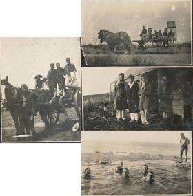
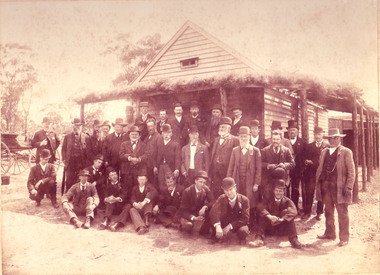
Photographs associated with Public Schools camp, that started in the 1930s. Some boys worked on chicory at McFee's farm. 314-05 was possibly located at Trenavin Farm, Ventnor. (Source Jan Andrews ) Photo of people on cart with tank stand was off to a 7 picnic at the Nobbies 1917. [See 1124-01] Keeston Sambell driving, behind him is Betty Parker. on side from left is May Lambert, Jim Patterson, Jim Blake, Carmen Sambell and Bill Sambell.[ Source Jim Blake] Eight black & white photographs. 314-01. Photograph of horse and cart with 2 women, 2 girls and 5 boys. 314-02. Photograph of a mixed group of 7 people on a horse and drag. 314-03. Photograph of 3 young adult males and a dog standing in front of a wooden building. 1926 “Campers Rest” Labelled The Immortal camp at Ventnor. Poss. Trenavin Park 314-04. Photograph of 5 boys and 1 woman swimming in rock pool. 1 boy watching. 314-05. Photograph of old wooden hut with tank and chimney. Appears to have been used by boys when camping. 314-06. Photograph of 4 boys - 2 in swimming costumes - on the beach. 314-07. Photograph of 3 women and 1 girl sitting on sand dunes. 314-08. Photograph of 3 boys in uniform and 1 man sitting on bench - maybe watching sporting event?scotch college camp phillip island, scotch college boys, s j mcfee, c.k. newman, f. r. newman, trenavin park phillip island, sambell family, jim blake, betty parker -
 Bendigo Historical Society Inc.
Document - COMMERCIAL BANK OF AUSTRALIA, PAY-IN SLIPS
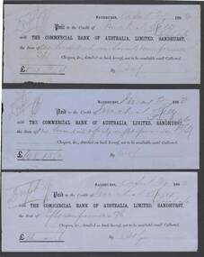
Three Pale blue 1883 The Commercial Bank of Australia, Limited, Sandhurst, pay-in slips. Hand written names difficult to interpret. Varying amounts paid to the credit of recipients.commerce, banking, the commercial bank of australia, limited, sandhurst. 19th century banking practice -
 Port Melbourne Historical & Preservation Society
Photograph - Swallow Street railway gates, Port Melbourne, 1975
Photographs taken by Glen Stuart and donated to the Society(6) B&W photographs taken at Swallow St railway gates about 1975, of a special diesel railcar - excursion train - on a visit to Princes Pier. (.01-.03) passing through the gates (.04-.05) at Bridge St railway crossing Northbound (.06) 2 car electric train, city boundtransport - railways -
 Moorabbin Air Museum
Document - T.Q.R.39 Performance Tests on DHAx3cDrover Fitted with Fairey Fixed Pitch Metal Propellers, De Havilland Aircraft Australia
-
 Ringwood and District Historical Society
Photograph, Maroondah Highway West, Ringwood, 1965. Wantirna Road bridge, start of widening
Black and white photograph (2 copies)Written on rear of backing sheet: "Wantirna Road bridge- the start". -
Moorabbin Air Museum
Document (item) - riveting drilling, CAC tooling INFORMATION FILE 1
-
 Kew Historical Society Inc
Plan - Subdivision Plan, Palmyra Estate, 1918
Pru Sanderson, in her groundbreaking ‘City of Kew Urban Conservation Study : Volume 2 - Development History’ (1988), summarised the periods of urban development and subdivisions of land in Kew. The periods that she identified included 1845-1880, 1880-1893, 1893-1921, 1921-1933, 1933-1943, and Post-War Development. These periods were selected as they represented periods of rapid growth or decline in urban development. An obvious starting point for Sanderson’s groupings involved population growth and the associated economic cycles. These cycles also highlighted urban expansion onto land that was predominantly rural, although in other cases it represented the decline and breakup of large estates. A number of the plans in the Kew Historical Society’s collection can also be found in other collections, such as those of the State Library of Victoria and the Boroondara Library Service. A number are however unique to the collection.The Kew Historical Society collection includes almost 100 subdivision plans pertaining to suburbs of the City of Melbourne. Most of these are of Kew, Kew East or Studley Park, although a smaller number are plans of Camberwell, Deepdene, Balwyn and Hawthorn. It is believed that the majority of the plans were gifted to the Society by persons connected with the real estate firm - J. R. Mathers & McMillan, 136 Cotham Road, Kew. The Plans in the collection are rarely in pristine form, being working plans on which the agent would write notes and record lots sold and the prices of these. The subdivision plans are historically significant examples of the growth of urban Melbourne from the beginning of the 20th Century up until the 1980s. A number of the plans are double-sided and often include a photograph on the reverse. In 1918, Punch reported the sale of the Palmyra Estate. ‘Adjoining the Findon Estate at Kew is Palmyra, one of the most charming localities in this most desirable of all suburbs. Palmyra has frontages to Findon, Bakewell, Carson and Stevenson streets. Facing Carson street are eight blocks of 60 by 140; on Stevenson-street four of 60 by 232; and there are four of 60 by 233 on Bakewell-street.’ [Bakewell Street and Findon Street were later to be amalgamated into Findon Crescent.]subdivision plans - kew, studley park, palymyra estate, stevenson street -- kew (vic.), carson street -- kew (vic.), bakewell street (findon crescent) -- kew (vic.) -
Tarnagulla History Archive
Photograph - Photograph: Tarnagulla group, c.1900
Williams Family Collection. Monochrome photograph of a large multi-generational group of people, probably at Tarnagulla around 1900. Further research required. A good copy photograph, laminated. tarnagulla -
 Bendigo Historical Society Inc.
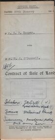
Document - H.A. & S.R. WILKINSON COLLECTION: CONDITION OF SALE
Contract of sale of land dated 29th January 1954 between Mr. E.M. Hopper (seller) and Mr. G.J. O'Donnell (buyer) for land being Lot 2 on plan of subdivision No. 23332 registered in the office of titles, Melbourne and situate in Lindsay Street Kangaroo Flat part of Crown allotment 11 section 23, township of Kangaroo Falt described in Certificate of title volume 7446 folio 423, together with weatherboard dwelling, wood shed-lavatory also fencing on the said land. Price 2,700 pounds.organization, business, h.a. & s.r wilkinson real estate -
Whitehorse Historical Society Inc.
Map, Melbourne Metropolitan Area Base Map, 1957?
Sheet 254 of part of the Municipality of Nunawading and part of the Parish of Nunawading, showing roads, block numbers, creeks and contours mostly south of Canterbury Road.Sheet 254 of part of the Municipality of Nunawading and part of the Parish of Nunawading, showing roads, block numbers, creeks and contours mostly south of Canterbury Road. Prep. from State Aerial and Cadastral survey information, August 1957. Scale: 400 ft = 1 inchSheet 254 of part of the Municipality of Nunawading and part of the Parish of Nunawading, showing roads, block numbers, creeks and contours mostly south of Canterbury Road. city of nunawading, cadastral -
 Stawell Historical Society Inc
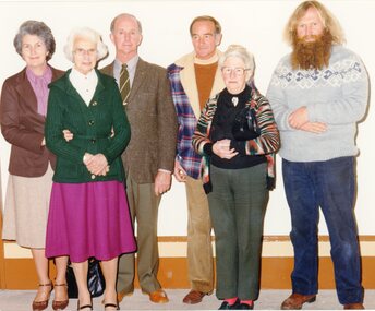
Photograph, Stawell Historical Society Inc. -- Original Members L to R Mrs Dawn Miller, Mrs H Croft, Mr Geoff Sudholz, Mr Allan Miller, Mrs Jean Hughes & Mr John Muller 1981 -- Coloured
Stawell Historical Society Inc. Original Members. L To R Mrs Dawn Miller. Mrs H Croft. Mr Geoff Sudholz. Mr Allan Miller. Mrs Jean Hughes and Mr John Muller. 1981stawell -
Glenelg Shire Council Cultural Collection
Photograph - Photograph - Portland Harbour, n.d
Port of Portland Authority Archivesport of portland archives, portland harbour -
 Melbourne Tram Museum
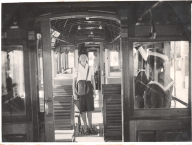
Photograph, Conductress - "Milly" Boundy, mid 1940s
Set of two photos: 1 - "Milly" Dorothy Boundy standing in the drop centre of a W2 class tramcar. Alongside can be seen a sailor in uniform and the driver looking from his compartment. Appears to be a summer scene during the mid 1940s as she is not wearing a jacket and possibly holding a ticket punch in her right hand. 2 - standing alongside a Victorian Railways bus or coach - Mount Buller service?Has a close association with wartime conductress "Milly" BoundySet of two black and white photographsOn rear of one photo has "Cath?"tramways, conductresses, w2 class, buses, vr buses, tramcars, interior -
 Bendigo Historical Society Inc.
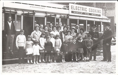
Photograph - GATHERING OF PEOPLE IN FRONT OF TRAM
Black and white photo of large gathering of people in front of tram. 2 tramway employees in uniform on right of photo, cap numbers 23 and 9. The sign advertises "Electric Cooking Service You Best!" above the tram.person, individual, basil miller -
 Kew Historical Society Inc
Plan, Melbourne & Metropolitan Board of Works : Borough of Kew : Detail Plan No.1568, 1905
The Melbourne and Metropolitan Board of Works (MMBW) plans were produced from the 1890s to the 1950s. They were crucial to the design and development of Melbourne's sewerage and drainage system. The plans, at a scale of 40 feet to 1 inch (1:480), provide a detailed historical record of Melbourne streetscapes and environmental features. Each plan covers one or two street blocks (roughly six streets), showing details of buildings, including garden layouts and ownership boundaries, and features such as laneways, drains, bridges, parks, municipal boundaries and other prominent landmarks as they existed at the time each plan was produced. (Source: State Library of Victoria)This plan forms part of a large group of MMBW plans and maps that was donated to the Society by the Mr Poulter, City Engineer of the City of Kew in 1989. Within this collection, thirty-five hand-coloured plans, backed with linen, are of statewide significance as they include annotations that provide details of construction materials used in buildings in the first decade of the 20th century as well as additional information about land ownership and usage. The copies in the Public Record Office Victoria and the State Library of Victoria are monochrome versions which do not denote building materials so that the maps in this collection are invaluable and unique tools for researchers and heritage consultants. A number of the plans are not held in the collection of the State Library of Victoria so they have the additional attribute of rarity.Original survey plan, issued by the MMBW to a contractor with responsibility for constructing sewers in the area identified on the plan within the Borough of Kew. The plan was at some stage hand-coloured, possibly by the contractor, but more likely by officers working in the Engineering Department of the Borough and later Town, then City of Kew. The hand-coloured sections of buildings on the plan were used to denote masonry or brick constructions (pink), weatherboard constructions (yellow), and public buildings (grey). Plan No.1568 covers the area bounded by Cotham Road, John Street, Sackville Street, and Edward Street. Alfred Street and Rowland Street are in shown in the middle of the plan. The two most notable buildings shown are ‘St Helliers’, the home of the Dumaresq family, and St Hilary’s Church and school. While the colours used to indicate St Hilary’s are grey as in other civic/public buildings, the first St Hilary’s Anglican Church was at this stage constructed in weatherboard. At the left of the plan, facing Sackville Street is a house named ‘Glencara’. The 1988 ‘Kew Conservation Study’ recorded that “The first documentary evidence of this house comes from Rate Books which record that in 1893 a Mrs Treadway was the owner of this building with an N.A.V. of £81? At that date the occupier of the house was Charles B. Kelly, a clerk, while by 1910 Kelly had become the owner of the property described in that year ‘as a six-roomed stone, brick and wood house with stables and outbuildings’”. Contrary to this description, the 1905 plan indicates that the house was entirely constructed of masonry.melbourne and metropolitan board of works, detail plans, mmbw 1568 -
University of Melbourne, Burnley Campus Archives
Photograph - Colour prints, Plants
3 photographs of succulents, cacti, etc. in envelope with "Chan." Not at Burnley. Not scanned.succulents, cacti, plants -
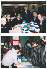 Melbourne Legacy
Photograph - Photo, Legacy Appeal 2005, Preparing for Badge Week, September 2005
Photos during Badge Week in September 2005 - poster says "Show your true colours" with an image of the different coloured badges available for sale. Photos of the preparations inside Legacy House for the badge sellers to collect their trays and collection tins. 007014.1 A Legatee briefing school children. 007014.2 The president Geoff Webb with a group of Navy personnel and their collection tins. 007014.3 School children's registering for their tins. 007014.4 The tins ready for collection. 007014.5 Navy personnel registering for their trays and tins. A record of the fundraising for the Legacy Appeal in 2005.Colour photo x 5 of preparation for selling badges, inside Legacy House.Printed on the back " -
 Eltham District Historical Society Inc
Photograph (Item) - Negative, Fred Mitchell, Eltham Town Park, 1988
Fred Mitchell 1988 Entrant No. 5 Ref: Series 34, Items 3, 4, 46-49 The images in this record were not selected for inclusion. SHIRE OF ELTHAM COMMUNITY PHOTOGRAPHIC SURVEY Photography is an artform which many of us practice, sometimes purely for artistic pursuit, sometimes to record the people and events in our lives. In 1988, as part of a local Bicentennial project, the Shire of Eltham conducted the Eltham Community Photographic Survey. Up to 100 entries were to be selected by a panel of photographers for entry into the Eltham Photographic Survey Exhibition. Entries had to be submitted by May 13, 1988. Entrants whose images were selected for the exhibition were contacted and requested to further submit an entry form providing entrant’s name, area of residence, age, and proposed captions. These details were then used to produce labels for the exhibition mounts. Where negatives had not been supplied, these were requested to support the display of printed enlargements mounted on 10” x 8” cardboard. The mounted prints were made available post exhibition for sale at $8.50 each for colour prints and $7.00 for B&W prints. Residents in the Shire were invited to collect a free roll of film and take a photograph of what they either liked or did not like about the area. A total of 160 entrants submitted multiple entries for the exhibition. Of those selected for exhibition, entrants ranged in age from 9 to 70 years. All custom colour and black and white printing for the exhibition was completed by Wattle Studios of Eltham. The Eltham Photographic Survey was jointly auspiced by the Shire of Eltham and Wattle Studios, of 953 Main Road, Eltham. The project was greatly assisted by: • David McRitchie, Media Studies Lecturer Victoria College, Rusden Campus. • Ian and Annette Toohill of Wattle Studios • Tracy Naughton, Eltham Community Arts Officer • Neville Emerson Pty. Ltd. • Superior Press, Eltham • Kodak Australasia Pty. Ltd. • Agfa Gevaert Ltd. • Townsend Colourtech Pty. Ltd. • The Australian Bicentennial Authority • Eleanor Bowers, Secretary, Eltham Arts Council The exhibition was placed on display in the Woolworths Arcade, Eltham between Monday June 6th and Saturday June 11, 1988. It was also intended to hold the exhibition at a venue in the Shire’s North Riding from Monday, June 20 to Friday June 24. It was then displayed at the Were Street Theatre, Montmorency from Friday, June 24 to Thursday, July 7. Series 34: Eltham Community Photographic Survey 1988 - Prints & Documentation Series consists of 117 photographs of Shire scenes taken by members of the community. Items I - 41 are larger photographs mounted on card, which were exhibited. Items 42 - 117 are unmounted copies, alternative takes and other entries. Corresponding negatives contained in Series 35: Eltham Community Photographic Survey 1988 – Negatives which consists of 267 colour and B&W negatives and one colour slide of Shire scenes taken by members of the community. The negatives are arranged by the entrant number of the photographer. The Eltham Community Photographic Survey collection is significant to the local community as it was curated by the local community - ordinary people of all ages - representing what they liked and did not like in the area where they lived. It represents an unfiltered representation of the Shire of Eltham as it was in 1988. It also represents one of many projects as part of the national programme of events and celebrations to commemorate the bicentenary. It is a time capsule of life in the 1980s of this urban and rural municipality in Melbourne's north. shire of eltham archives, bicentennial project, eltham, eltham community photographic survey, series 35, alistair knox park, eltham town park, film - kodak ga 100 5095, fred mitchell, scan - 35mm negative, playground -
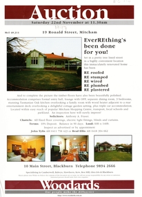 Whitehorse Historical Society Inc.
Document, 19 Ronald Street, 1997
Real Estate agent's advertisementReal Estate agent's advertisement for No 19 Ronald Street, Mitcham.Real Estate agent's advertisement ronald street, mitcham, no 19 -
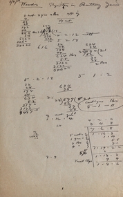 Federation University Historical Collection
Document, Two documents relating to suplies at the School of Mines Ballarat
Mr Martell was the director of the School of Mines Ballarat, which is a predecessor of Federation UniversityTwo pages .1 Small handwritten note to Mr Martell from N. Woods .2 Page of handwritten figures mr martell, n. woods, pyrites in battery, pyrite, battery, school of mines ballarat -
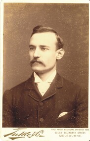 Bendigo Historical Society Inc.
Photograph - HARRIS COLLECTION: MALE PHOTO, Nineteenth Century
Head & Shoulders male aged approx 30. Suit coat. Printed on Front. Tuttle & Co 62 & 64 Elizabeth Street Melbourne. First award Mel Exhibition 1888.Tuttle & Co 62 & 64 Elizabeth St Melbourne.photograph, person, male -
 Bendigo Historical Society Inc.
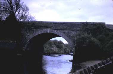
Photograph - HARRY BIGGS COLLECTION: OUNAVARA RIVER/CARADON HOUSE
Document & Slide. Harry Biggs Collection. A slide of the bridge over Ounavara River. Wrapped in tissue. This is attached to note paper on which is written,' Illawong' Corop. June. Dear Mr Biggs, Thankyou for the loan of your slide. I hope my slowness to return it hasn't inconvenienced you. Yours faithfully Della Palmer. Della Palmer P.O. Box 156 Rochester 3561. Caradon File. Attached to this is an envelope containing a card in an envelope from Phyllis Berryman. It is relating to an embroidered screen made by Carolyn , Dr Richard Jones wifeplace, building, site, harry biggs collection, caradon house, ounavara river bridge -
 University of Melbourne, Burnley Campus Archives
Photograph - Black and white photocopy, A.E. Bennett, Members of the Horticultural Board Outside the Dunolly Town Hall, 1893
Photocopy of a photograph. (1) "Group photograph following luncheon at Government Scent Farm, Dunolly on the second annual trip of the Students of the Horticultural College, Burnley, 23.11.1893. Val Caire photo, 57 Toorak Rd Sth Yarra." (Descendent of J.N. Caire.) Photocopy donated by Bruce Draper, descendent of Charles Draper. (2) Handwritten list of names: "Members of the Horticultural Board, Professor McAlpine, Mr Max Pincus?, Mr J.N. Caire, Mr McFarlane, Mr Ogle, Mr Churchill, with the Mayor of Dunolly J. Desmond Esq. J.P. and students of the Horticultural College, Burnley outside the Dunolly Town Hall on the second annual trip of students to the Government Scent farm, 23rd November, 1893. (3) Photocopy of A.E. Bennett's "Prize Essays, "Essay on trip to Dunolly Scent farm, 1893." p117.luncheon, government, scent farm, dunolly, trip, students, horticultural college, burnley, val caire, bruce draper, charles draper, horticultural board, professor mcalpine, max pincus, j.n. caire, mr mcfarlane, mr ogle, mr churchill, j. desmond esq., students, town hall, a.e. bennett, prize essays -
 Bendigo Historical Society Inc.
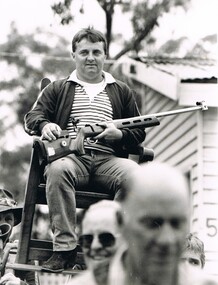
Photograph - BENDIGO ADVERTISER COLLECTION: SPORTS STAR AWARDS PRESENTATIONS
Black and white photograph, 1 man, photograph of Geoff Grenfell on a chair that is being carried around by 6 people whilst holding a rifle in his hand. Bendigo Advertiser description on back of photo: Geoff Grenfell Georgecap SLArecreations, sports, awards -
Whitehorse Historical Society Inc.
Article, Nunawading Shire Presidency, c1915
Article about election of Cr H.E. Davis a Shire President.Article about election of Cr H.E. Davis a Shire President.Article about election of Cr H.E. Davis a Shire President.local government, shire of nunawading, davis, h.e. -
 St Patrick's Old Collegians Association (SPOCA)
Photograph - SPOCA, Annual Dinners
-
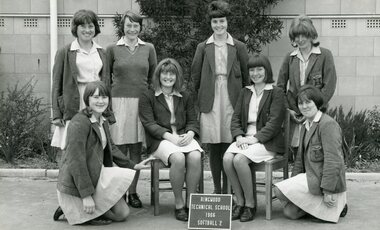 Ringwood and District Historical Society
Photograph - Group, Ringwood Technical School 1966 Softball 2 Team, c 1966
Black and White Photographrts, ringwood tech -
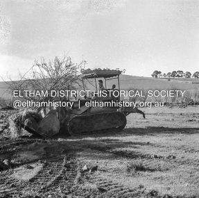 Eltham District Historical Society Inc
Negative - Photograph, J.A. McDonald, Kangaroo Ground-Queenstown Road, Aug. 1960
(Kangaroo Ground-St Andrews Road) “Rymers” Corner – shifting Hawthorn hedges on Tompkins property Council’s Drott 6 Woods Drott 9 August 1960 Showing hedge in rear already transportedRecord of various Shire of Eltham infrastructure works undertaken during the period of 1952-1962 involving bridge and road reconstruction projects, sometimes with Eltham Shire Council Project Reference numbers quoted. It was during this period that a number of significant improvements were made to roads and new bridges constructed within the shire that remain in place as of present day (2022). In many situations, the photos provide a tangible visible record of infrastructure that existed throughout the early days of the Shire. The album was put together by or under the direction of the Shire Engineer, J.A. McDonald.infrastructure, shire of eltham, 1960-08, garden hill, kangaroo ground, kangaroo ground-queenstown road, kangaroo ground-st andrews road, rymers corner, bulldozer, drott -
National Vietnam Veterans Museum (NVVM)
Document, Payment for Information Leaflet, 1969-1973 (Approximate)
Yellowing leaflet addressed to Australian personnel. All information is printed in upper case and same font size. One paragraph of three sentences and the second paragraph of two sentences. Reverse side has two shields with a kangaroo in each.Atttention Australian Personnel Two paragraphs informing personnel of what to do if presented with this leaflet. The reverse side is in Vietnamese and offers payment for information givenleaflet -
Federation University Historical Collection
Document - Document - Design, E J Barker: Ballarat College of Advanced Education: Final Year Project Report; "Internal Combustion Engine Driven Heat Pump", 1984
Mechanical Engineering Department Ballarat C.A.E. Final Year Report submitted by John Barker, 1984. The Report was "Internal Combustion Engine Driven Heat Pump". His supervisor was L E Taylor. The location of the experimental rig was in the Thermodynamics Laboratory at Ballarat Council of Advanced Education. This project involved the design, construction and limited testing of an Internal Combustion Engine Driven Heat Pump, utilising full waste heat recovery, for the purpose of heating mains supply water. John is the son of Jack Barker, foundation director of Ballarat College of Advanced Education.75 page report - typed with photos and diagrams. 38 pages - Appendix 1-8engineering, vice principal, foundation director, ballarat college of advanced education, bcae, mount helen campus, engineering drawing, design, manufacture, heat engines, internal combustion engine, report, supervisor, l e taylor, john barker, internal combustion engine driven heat pump, heat recovery, thermodynamics laboratory