-
 Moorabbin Air Museum
Article (Item) - Photocopy of article called RAAF Transport Flight (Japan)
-
 Kew Historical Society Inc
Financial record, Auburn Heights Recreation Club, Accounts Ledger, 1904-1908
Sports Clubs in Kew in the final decades of the 19th century and in the early 20th century were often umbrella organisations with facilities for a number of sports. Typically in Kew, this included teams in lawn bowls, tennis and croquet. The Kew Bowling Club was formed in 1880 while the privately owned Auburn Heights Recreation Club was opened in 1904. By 1998, the two Clubs decided to amalgamate at the Auburn Heights site in Barkers Road, forming the Kew Heights Sports Club. The combined club was itself taken over by the Melbourne Cricket Club in 2012 becoming MCC Kew Sports Club. In 2017 MCC Kew closed and its landholding was subsequently sold to Carey Baptist Grammar School. Both the Kew and Auburn Heights Clubs assembled important collections. These historically significant and large collections were donated to the Society in 2020. The collections include manuscripts, pictures, trophies, plans, honour boards etc. References Barnard FGA 1910, 'Sports and Pastimes' in Jubilee History of Kew Victoria: Its origin & progress 1803-1910. Chapman J & C 1999, The history of the Auburn Heights Recreation Club, 1904 to 1908. Reeve S 2012, City of Boroondara: Thematic Environmental History, p.216.The combined collections of the four sporting clubs making up the collection number hundreds of items that are historically significant locally. They are also significant to the sporting history of the greater Melbourne area and to the sports of lawn bowls and tennis in Australia in the 19th and 20th centuries. The collection illuminates two of the Victorian historic themes - 'Building community life' through forming community organisations and 'Shaping cultural and creative life' by participating in sport and recreation.The first bound Accounts Register of the Auburn Heights Recreation Club covering the period 1904 to 1908. [The item is part of the large historic Auburn Heights Recreation Club collection, including items relating to the sports of lawn bowls, tennis and croquet, gifted to the Kew Historical Society in 2020].clubs - lawn bowls - kew (vic), auburn heights recreation club - barkers road - kew (vic), auburn heights recreation club - minute books -
Whitehorse Historical Society Inc.
Article, Funding decision averts local government crisis, 1991
The federal government has rejected a Commonwealth Grants Commission proposal to slash local government funding by 50%.The federal government has rejected a Commonwealth Grants Commission proposal to slash local government funding by 50%. This money is used for capital works and would have been sorely missed.The federal government has rejected a Commonwealth Grants Commission proposal to slash local government funding by 50%.local government finance, city of nunawading -
 Bendigo Military Museum
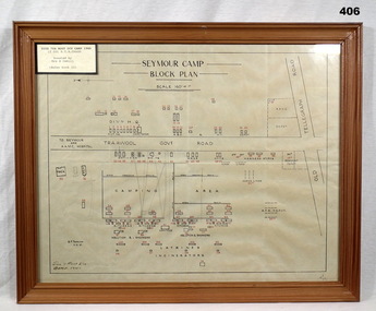
Map - PLAN, FRAMED
LT COL BENJAMIN THOMAS ROY CHADD No's 10594, VX20311, 1st and 2nd AIF. Refer 2039 for Service History also 2034P. Plan, detailing Seymour Camp Block Plan, Signals 7th Aust Div Camp 1940, re LT COL BENJAMIN THOMAS ROY CHADD. Tan coloured frame, glass front, cardboard backing, detail of camp layout, scale 160' = 1".documents - maps/plans, military history - army, frames -
 Melbourne Tram Museum
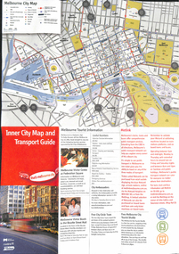
Map, City of Melbourne, "Inner City Transport Map", c1990
Map - 6 fold DL - full colour titled "Inner City Transport Map", providing information for Tourist Information centres, Metlink. Melbourne City Tourist Shuttle, and two maps, one provided by Melway giving a list of attractions. Published by City of Melbourne, Melway and Metlink with each of their logos.trams, tramways, map, public transport, city of melbourne, metlink -
University of Melbourne, Burnley Campus Archives
Article - Photocopy, Horticultural education - future policy, 1965
Article in Gardener's Chronicle, Vol. 158, No. 15, 1965gardener's chronicle -
Whitehorse Historical Society Inc.
Article, RSL Branch marks 80 years, 2000
Mitcham RSL celebrated 80 years in Feb. 2000Mitcham RSL celebrated 80 years in Feb. 2000Mitcham RSL celebrated 80 years in Feb. 2000mitcham returned servicemens league, celebration -
 Mission to Seafarers Victoria
Article - Magazine article, Louis Peters, Sign of the Times by Louis Peters, July-September 1965
The Siddely Street Sailors' Home was built in 1904 to replace the former Spencer Street building. The home closed its doors on 31 January 1963. In 1965 the building was sold and it was later demolished and the site redeveloped. Ernst (Ernest) Waldemar Kaiser (1893-1968) was the last and longest serving superintendent of the home (March 1933 - March 1965). He was employed till 31 March 1965 (year of the article) when he finished up after 32 years in the position. He continued to be employed for a year or so after the home closed, probably serving as caretaker till it was sold. (see Mark Howard paper in the Great Circle (Vol.42, No1).) The plaque photographed on page 25 is to be incorporated in the Seafarers park located next to the new Seafarers residential building and at the back of the Mission.3 pages (p21 to 26) of the Port Melbourne Quarterly issue July-September 1965 about the Melbourne Sailors Home located on Spencer Street.Inscription handwritten in black ink in capital letters by Nancy Oakley: Meetings of Melb. Sailors' Home held at office of Mr Theo H. Swanton Managing Dir. of William Crosby & Co., 464 Collins St. Melb.nancy oakley, sailors' home, mission to seamen, nancy dingle, mrs v. kaiser, chinese dolls, kakariki, ernest kaiser, theo h. swanton, ernest waldemar kaiser -
Whitehorse Historical Society Inc.
Article, Deal close in Vermont land battle, 1990
Article about the negotiation between the residents and land developers over Wunderlich site developmentArticle about the negotiation between the residents and land developers over Wunderlich site development.Article about the negotiation between the residents and land developers over Wunderlich site developmentrooks road vermont, land subdivision, mitcham road vermont, wunderlich limited -
Whitehorse Historical Society Inc.
Article, Kits get drugs right, 1991
To educate children on the sensible use of medicine the Maroondah Apothecary Pharmacy in Mitcham has developed a school resource kit specifically for 11 - 12 year olds called 'Using drugs for good or ill'.To educate children on the sensible use of medicine the Maroondah Apothecary Pharmacy in Mitcham has developed a school resource kit specifically for 11 - 12 year olds called 'Using drugs for good or ill'.To educate children on the sensible use of medicine the Maroondah Apothecary Pharmacy in Mitcham has developed a school resource kit specifically for 11 - 12 year olds called 'Using drugs for good or ill'.medicines, maroondah apothecary, mcdonald, adam, minwalla, abby, greenberg, george -
 Hymettus Cottage & Garden
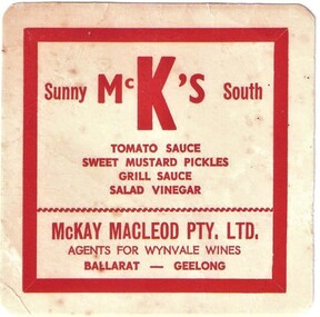
Article - McKay's Sunny South coaster, c.1960
-
Moorabbin Air Museum
Plan (item) - Power Distribution Box Assembly - Hydraulic Power Cart United Technologies Sikorsky Aircraft
Drawing No.65725-76293 Rev.1 -
Glen Eira Historical Society
Article - ELSTER AVENUE, 16, ELSTERNWICK
This file contains 6 items: 1/Handwritten notes by Peta Darke dated 25/07/2014 listing title details for 16 Elster Avenue from 1909 to 2009 – two pages. 2/Handwritten list of Sands and McDougall entries for the property from 1915 to 1940 dated 25/07/2014 compiled by Peta Darke. 3/A photocopy of a Biggin Scott Real Estate Agents flyer advertising the recent sale of the property in 2009. 4/Print out from ‘The Argus’ of 04/12/1917, Page 6, from the Trove website of a brief article concerning the wounding of S.P.Jones, son of Stephen Jones of ‘Mons’, Elster Avenue in November 1917. 5/A photocopy of colour photograph of exterior of 16 Elster Avenue Circa 1998 taken by R.Darke. 6/Article from ‘Caulfield Glen Eira Leader’ of 25/03/2014, Page 3, concerning Oscar Jones, 14 year old son of present owners, who is an excellent surf life saver. Includes colour photograph of Oscar.elster avenue, college street, bowood, elsternwick, bowden arthur william, mons, hartington street, parnell street, jones stephen alma, kooyong road, kendall ann bell, kendall james william, kendall harold duncan, morrison harold lindsay, morrison rhonda may, cook jean isobel, golding ida curnow, perrett craig stuart, perrett eileen mary, perrett edward, perrett anthea, perrett catherine, lewis kay margaret, swain anthony barry gilles, swain darcy, swain mitchell, jones adrian, jones karine stehman, jones oscar, jones patrick, thomas lloyd, rickman jacob, lee james t, nidschelm harold, regan francis, jones douglas, laughton martin, biggin and scott, ashton daniel, jones stephen percy douglas, architectural styles, edwardian style, timber houses, gardenvale, collinson william morris, thomson william hamilton, lempriere john thompson -
Bendigo Historical Society Inc.
Map - PLAN OF THE BENDIGO RAILWAY YARD, Circa 1960
Map: Plan of the Bendigo Railway Yards, Scale: 80 feet to 1 inch. 1960's. (number 319 in map cupboard 1) Location unknown. Image in Mosaic images overflow.map, bendigo, railway yard, railways, rail yards, station layout -
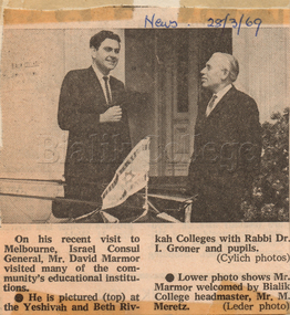 Bialik College
Article (item) - Israel Consul General Mr David Marmor, The News, 28 March 1969, 1969
News article about Israel Consul General Mr David Marmor, published possibly in The Jewish News, 28 March 1969. Please contact [email protected] to request access to this record.shakespeare grove, 1960s -
Bendigo Historical Society Inc.
Map - DEVONSHIRE GROUP OF MINES
Small map of Devonshire group of mines, Bendigo. Scale 8 chains to 1 Inch. Issued by M. P. Kelly sharebroker, Bendigo. Showing Hercules and Energetic, Pearl, New Victoria Catherine,, New St Mungo, xtended south devonshire, South Devonshire, United Devonshire,duchess of Edinburgh, Phoenix, South st Mungo, Lady Barkly, St. Mungo, Sadowa, Ellenborough, Williams' United, Catherine Reef United.bendigo, mining, devonshire mine -
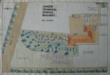 Federation University Historical Collection
Plan, Ballarat Junior Technical School Plan - Ballarat Gaol Reserve, 1934
Coloured plan of the Ballarat Junior Technical School and where is was situated in relation to the Ballarat Gaol and its walls, and the Ballarat School of MInes grounds, battery and tennis courts.ballarat gaol, ballarat gaol reserve, ballarat junior technical school, plans, dodge ball court, ballarat school of mines battery, model mine, ballarat school of mines model mine, ballarat junior technical school rifle range, ballarat junior technical school cricket pitch, ballarat junior technical school tennis court, rifle range, albert street, grant street, mining battery, tennis court, ballarat gaol wall, bicycle shed, ballarat school of mines mining battery -
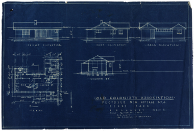 Old Colonists' Association of Ballarat Inc.
Plan, Old Colonists' Association Proposed New Cottages No. 4, Sheet 5, c1925
Blueline plan of the Old Colonists' Association. old colonists' association ballarat, charles anderson grove, retirement village, old colonists' association ballarat cottages -
Glen Eira Historical Society
Article - Koornang Road, 223, Carnegie
Advertisement dated 10/04/2004 from Caulfield Glen Eira Leader for the sale of 223 Koornang Road. Includes brief description and colour interior.carnegie, koornang road, brick houses, architectural styles, staples mark, sweeney damien -
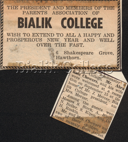 Bialik College
Article (item) - Welcome reception for Chowers family, c. 1963-1964
Newspaper clipping about a welcome reception held for the new headmaster Abraham Chowers and his family, c. 1963. Please contact [email protected] to request access to this record.event, principal, 1960s, shakespeare grove -
 Whitehorse Historical Society Inc.
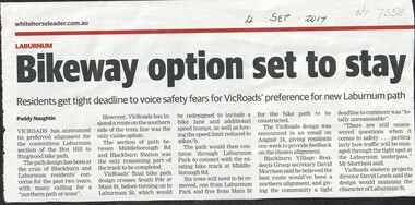
Article, Bikeway Option Set To Stay, 2017
VicRoads has announced its preferred southern alignment of the bicycle path between Middleborough Road and Blackburn Railway Station with only one week for residents to respond.bicycle paths, laburnum, vicroads, middleborough road, blackburn, blackburn railway station, laburnum street, blackburn village residents group -
Whitehorse Historical Society Inc.
Map, Aboriginal sites in the City of Doncaster-Templestowe, 1/03/1991 12:00:00 AM
Map of City of Doncaster and Templestowe.Map of City of Doncaster and Templestowe showing location of stone artefacts and scarred trees.Map of City of Doncaster and Templestowe. aborigines, city of doncaster and templestowe -
Glen Eira Historical Society
Article - Koornang Road, 81-81A, Carnegie
A colour newspaper article, source unknown, dated 03/08/2001, advertising the auction of two shops at 81 and 81A Koornang Road on 17/08/2001. The article includes a colour photograph of the building exterior.carnegie, koornang road, shops, auctions -
Whitehorse Historical Society Inc.
Article, Nunawading Schools Arts & Education Project
Photographs of Heatherwood Developmental Secondary School's displays for the Nunawading Schools Arts & Education Project.nunawading schools arts & education project, heatherwood developmental secondary college, mourney, hazel -
Melbourne Tram Museum
Map - Metlink folder - Travel Smart Maps, Travelsmart - Department of Infrastructure, "Melbourne's Public transport Map", 2005 to 2006
Set of four maps issued by Metlink - 2005 to 2006 contained within a Metlank badge plastic folder. Maps published in association with Melway 1 - 5 x 8 fold map with card cover dated Jan 2005 with a price of $2. Detailed map showing rail, tram and bus routes. 2 - 6 x 4 fold map for Moonee Valley - Travelsmart - for public transport, walking and cycling - dated 2005 3 - 7 x 4 fold map for Moreland - Travelsmart - for public transport, walking and cycling - dated October 2006 - includes notes on taxis. 4 - 7 x 4 fold map for Ride to Work day - 5 Oct. 2005Yields information about Melbourne Public Transport network.Metlink plastic folder containing maps.maps, metlink, public transport, moreland, moonee valley, travelsmart -
 Kew Historical Society Inc
Plan, Melbourne & Metropolitan Board of Works : Borough of Kew : Detail Plan No.1563, 1905
The Melbourne and Metropolitan Board of Works (MMBW) plans were produced from the 1890s to the 1950s. They were crucial to the design and development of Melbourne's sewerage and drainage system. The plans, at a scale of 40 feet to 1 inch (1:480), provide a detailed historical record of Melbourne streetscapes and environmental features. Each plan covers one or two street blocks (roughly six streets), showing details of buildings, including garden layouts and ownership boundaries, and features such as laneways, drains, bridges, parks, municipal boundaries and other prominent landmarks as they existed at the time each plan was produced. (Source: State Library of Victoria)This plan forms part of a large group of MMBW plans and maps that was donated to the Society by the Mr Poulter, City Engineer of the City of Kew in 1989. Within this collection, thirty-five hand-coloured plans, backed with linen, are of statewide significance as they include annotations that provide details of construction materials used in buildings in the first decade of the 20th century as well as additional information about land ownership and usage. The copies in the Public Record Office Victoria and the State Library of Victoria are monochrome versions which do not denote building materials so that the maps in this collection are invaluable and unique tools for researchers and heritage consultants. A number of the plans are not held in the collection of the State Library of Victoria so they have the additional attribute of rarity.Original survey plan, issued by the MMBW to a contractor with responsibility for constructing sewers in the area identified on the plan within the Borough of Kew. The plan was at some stage hand-coloured, possibly by the contractor, but more likely by officers working in the Engineering Department of the Borough and later Town, then City of Kew. The hand-coloured sections of buildings on the plan were used to denote masonry or brick constructions (pink), weatherboard constructions (yellow), and public buildings (grey). This plan covers the area between Barkers Road, Wrixon Street, Sackville Street and Brougham Place, much of it now occupied by Carey Baptist Grammar and Preshil schools. This was an area of large and prestigious homes in 1903, some with formally laid-out gardens, such as ‘Tower Hill’ and ‘Opawa’. ‘Kalimna’ was built in 1890-91 for William H. Jarman, an accountant, and ‘Blackhall’ at the same time for W.H. Roberts. Blackhall was to be acquired by the Salvation Army in 1915 and renamed ‘Catherine Booth Girls’ Home’. The Home accommodated girls, aged between 4 and 16. Kalimna and Blackhall are of significance as typical and intact late Victorian mansions and as such are two key Victorian buildings to have been built in Kew. Both Blackhall and Kalimna are now part of Preshil. ‘Fairview’ was for a long time occupied by the Sisters of St. Joseph of Cluny as a care home for the elderly, but it is now part of Carey Grammar School, as are the grounds of ‘Wagga Merne’, ‘Weemutta’, ‘Blakely’, ‘Daheim’ and ‘Mildura’ (later ‘Urangeline’), the last being particularly impressive in 1903, with a tennis court, conservatory, outhouses, and two bathrooms!melbourne and metropolitan board of works, detail plans, mmbw 1563, cartography -
Bendigo Historical Society Inc.
Map - HUNTLY RESURVEY, 1873
Map: Huntly resurvey. Parish plan ( number 242 in Map Cupboard 1)map, bendigo, parish plan, huntly -
Whitehorse Historical Society Inc.
Article, Love began at Mitcham factory, 2005
Article about the 70th wedding anniversary of Pat and Gladys McClare who grew up in Mitcham.Article about the 70th wedding anniversary of Pat and Gladys McClare who grew up in Mitcham. McClare Road Vermont is named after Pat's grandfather who owned a tannery (Photo)Article about the 70th wedding anniversary of Pat and Gladys McClare who grew up in Mitcham. mcclare, pat, mcclare, gladys, mcclares road vermont -
Whitehorse Historical Society Inc.
Article, The Grange, n.d
'Survivor of the old days', article on 'The Grange', 14a Gordon Crescent, Blackburn, built 1888.gordon crescent, blackburn, the grange, auctions -
Port Melbourne Historical & Preservation Society
Plan, "State Bank of Victoria - Proposed dwelling Fishermans Bend"
Plans were brought to us for copying 19.05.2011 by CBA employee Steve Tserkezidis, who has access to old State Bank records. Borrowed for scanning by Gavin Rowson who put them on CD and returned 07.06.2011From series of State Bankhouse plans and elevations of types 1 - 8. A1 copies (.01) 1937 (stamp). (.02) 1928. (.03) 1937. (.04) 1937. (.05) no date. (.06) 1928. (.07) 1937. (.08) 1938. From plans accompanying bank House plans .01 to .08; (.09) MMBW plan showing bank properties (.10) Bank house plan: sections through walls. (.11) "Fishermans bend group" plan of properties (.12) Bank House plan of Pier Foundationgarden city, built environment - domestic, state savings bank of victoria, bank houses