-
 Tatura Irrigation & Wartime Camps Museum
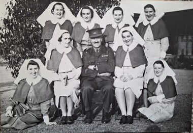
Photograph, No 28 Camp Hospital staff, Original 1942, copy 1989
Nursing staff and senior medical officer of No 28 camp hospital (Waranga Hospital) at Tatura 15 June 1943. Back row (l to r): Sister L G W Anderson, Sister D A McLeod, Sister A I Barden, Sister I A Paterson. Middle row (l to r): Sister B Moore, Major J Morlet, Sister D J Steed. Front: Sister M W Trott and Sister K Heaphy. Black and white photograph of 4 female nursing staff standing, 2 female nursing staff and male Army officer seated and 2 female nursing staff seated on ground. Tree directly behind them. Hut nearby to the right.internment camps, tatura internment camps, internment camp hospitals, internment camp hospital staff, captain morley, sister beatrice moore, waranga hospital, sister l g w anderson, sister d a mcleod, sister a i barden, sister i a paterson, sister b moore, major j morley, sister d j steed, sister m w trott, sister k heaphy -
 Glenelg Shire Council Cultural Collection
Photograph - Photograph - Portland, Victoria, c. 1940
Black and white photo from Whaler's Bluff, looking south. Nun's Beach, baths, Ocean Pier, Railway Pier, Henty Beach, Battery PointBack: 'The Beach and Piers, Portland' - black print -
Moorabbin Air Museum
Manual (Item) - RAAF AAP 7805 016 2 3 ATE Model 28 Automatic Send/Receive Set Transmitter Distributor Maintenance Manual
-
 Glenelg Shire Council Cultural Collection
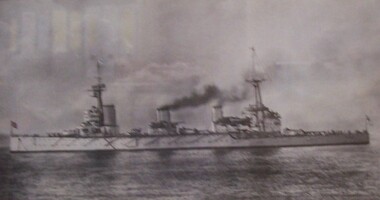
Photograph - Photograph - HMAS Australia, 1913-1920, c. 1920
Black and white photograph of a steam ship at sea. Mounted on cream matt, under glass in wooden frame made from teak from the ship's deck.Front: HMAS AUSTRALIA First flagship of the Royal Australian Navy 1913-1920 . Sunk under Terms of the Washington Treaty 12th April 1924. This frame is of teak from her deck (metal plaque, lower centre of frame). Back: (no inscriptions) -
 Surrey Hills Historical Society Collection
Photograph - 19 Kingsley Crescent, Mont Albert, The Street Where You Live Project
Photos documenting this address as part of a photographic series undertaken by volunteer photographers during 2013 and 2014 for The Street Where You Live Project. This was organised through the Surrey Hills Neighbourhood Centre and covered the postcode 3127 in the cities of Boroondara and Whitehorse.These photos provide a snapshot of real estate in the suburbs of Mont Albert and Surrey Hills during a period of rapid change with many properties on large blocks demolished to create higher density residential development or renewal of single dwellings. At particular risk were properties not covered by heritage overlays, in particular interwar housing and post 1950's housing. -
 Stawell Historical Society Inc
Photograph, Stawell Music Ensemble of Oklahoma -- Named 1991
Stawell Music Ensemble 1991 Oklahomastawell -
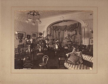 National Trust of Australia (Victoria)
Photograph, Drawing room, c1903
Black and white photograph mounted on light grey coloured card. Photograph shows Sargood's Drawing Room looking towards the north facing bay window.Stamped onto front left bottom corner of photograph: 'Johnstone & O'Shannessy/ & Co./ Propy. Ltd/ Collins St. Melb.' Written on photograph: 'DRAWING ROOM' rippon lea, sargood family -
 Kew Historical Society Inc
Photograph - Flooding of the Yarra Valley at Kew East, 1974
Flooding of the Yarra Valley, including that section of the Yarra bordering Kew and Kew East in the north and west of the municipality, was a regular occurrence. Extreme flood events of the Yarra River are recorded to have occurred in 1891, 1901, 1916, 1923 and 1934. The Municipality of Kew's response to these floods was to enact planning decisions restricting residential development in flood prone areas following the floods of 1916, 1921 and 1934. While floods continued after the development of the Upper Yarra Reservoir (construction 1948-57), the regularity and extent of these inundations diminished. During the nineteenth century, the land abutting the south side of the Yarra in Kew was devoted to dairy farming. In the twentieth century, before and after the construction of the Eastern Freeway, much of this low-lying area was used as golf courses and public parks.Late example of the capacity of the Yarra Valley at Kew to flood, even though drainage works and the Upper Yarra Reservoir had reduced their regularity.Original black and white print photograph of the low-lying land at East Kew under floodwater on 16 May 1974. The photograph is of Hyde Park looking north-east.Annotation verso: "Hyde Park looking nth-east / Flood Level / 16 May 1974 11.15am / R.L. 46.61"floods, yarra river, hyde park -
University of Melbourne, Burnley Campus Archives
Photograph - Black and white print, 55. Lunch Group on Lawn Under Pine
Group of female students lying on the lawn.Labelled, "Lunch Group on Lawn Under Pine."female students, lawn, mrs. jessep, alexander william jessep, principal, a.w. jessep -
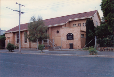
 Kew Historical Society Inc
Photograph - Former Kew Police Station : Carpark, 1996
A civic campaign for new public offices developed in Kew in the 1880s. After much deliberation, the location chosen was the junction of Bulleen and Cotham Roads. The buildings were designed by George Watson and John Henry Harvey, architects within the Department of Public Works (Victoria). Building was commenced in 1887, and after one year, the buildings were opened. The Post Office was transferred to the new Commonwealth Government in 1901. The Police Station and Court House, sold by the Victorian Government to the City of Boroondara in 2007, are now a community cultural centre and performing arts venue.The buildings were listed on the Victorian Heritage Register Register (HO885) in 1991. They are historically and architecturally significant to the State of Victoria because Watson and Harvey's designs exhibit diversity in integrating civil offices, they accommodate the apex of road junctions, and they demonstrate a departure from the contemporaneously favoured High Victorian Classical to the Queen Anne style in the design of civic buildings.View of the carpark at the rear of the Kew Police Station which faces Cotham Road. The garage is a twentieth century addition.Nilkew police station, kew court house, public office - kew (vic.) -
Port Melbourne Historical & Preservation Society
Photograph - Corner Ross and Bridge Streets, Port Melbourne, Glen Stuart, c. 2000
Glen Stuart, who lives near opposite corner, took progressive photos of changes to this propertyOne of six colour views of corners of Ross and Bridge Street, showing original shop and progression of new development as photographed by Glen Stuart, 1991 and 2000: View of the milk bar on southwestern cornerDetails are in pencil on backbuilt environment - domestic -
Glenelg Shire Council Cultural Collection
Photograph - Photograph - Bridge Construction, Portland, 04/10/1957
Port of Portland Authority ArchivesFront: Back- '4/10/57' - blue biroport of portland archives, canal bridge, construction, workmen -
 Eltham District Historical Society Inc
Photograph, Liz Pidgeon, Heritage Excursion; Eltham Lower Park Walk and Talk, 1 July 2017
Newsletter No., 234, June 2017 Heritage Excursion - Saturday 1st July - Eltham Lower Park - Walk and Talk Eltham Lower Park has played an important part in the history of our area since the early days of European settlement when it was used by local residents as an informal racecourse. Prior to that its location at the junction of the Diamond Creek and the Yarra River made it an important meeting place for the Wurundjeri people. The park combines formal elements and sporting facilities with remnant bushland that is of environmental significance. It is home to sporting and horse riding clubs, popular play spaces and the Diamond Valley Miniature Railway, which attracts large numbers of visitors. The park will be the venue for our July excursion which will comprise a walk of about 3.5 km around the park and adjacent areas. Along the way we will discuss the history and natural history of the area. The path along the creek and the river provides a pleasant and scenic walk. This walk on Saturday 1st July is about 3.5 km in length and will take 2 to 2.5 hours. It will start at 2pm at the Main Road car park at the front of the park. (Melway ref 21 H 10). Born Digitalheritage excursion, activities, eltham district historical society, eltham lower park, walking, trail -
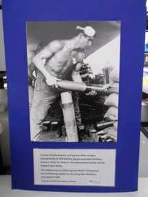 National Vietnam Veterans Museum (NVVM)
Photograph, 104 Battery
Black and white Photograph of Gunner Charlie Hayden and Mike Longley preparing shells for firing at Fire Support Base Betty in Long Binh Province in March 1969photograph, royal australian artillery, long binh -
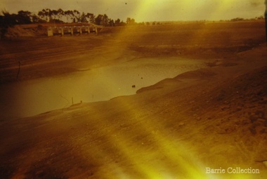 Melton City Libraries
Photograph, Exford Weir, c.1961
Photos of The Exford Weir looking drymisc. -
Stawell Historical Society Inc
Photograph, Stawell Technical School's Little Gas Engine
Stawell Technical School Little Gas Enginestawell education -
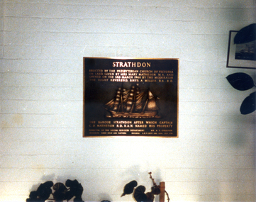 Whitehorse Historical Society Inc.
Photograph, Plaque at Strathdon Retirement Home, 3/03/1968 12:00:00 AM
Coloured photo of Plaque at Strathdon Retirement Home.matheson, charles, strathdon community -
 Ringwood and District Historical Society
Photograph, Southwood Primary School Grade 6H, 1990, Class photo
Southwood Primary School Grade 6H, 1990, Class photoincludes student names -
Moorabbin Air Museum
manual (item) - Aerial Targeting Systems, Scale Model Mirach 100/5 Aerial Target
-
 Bendigo Military Museum
Article - Aerial photography Diapositive Filter Plate, circa 1960
Aerial photography glass plate filter used in the production of aerial photography for mappingWooden box, lacquered, hinges and clasps, blue felt lined, glass plateroyal australian survey corps, rasvy, fortuna, army survey regiment, army svy regt, asr -
 Buninyong & District Historical Society
Photograph - Original Photograph, Mr. C.J. Brooks, Interior Buninyong Courthouse, view of wood-lined ceiling, with ceiling rose and brass support rod for lights, November 1995
Social/ political, legalColour photo, Interior Buninyong Courthouse, view of wood-lined ceiling, with painted ceiling rose and brass support rod for lights.buninyong, courthouse, buninyong council chamber -
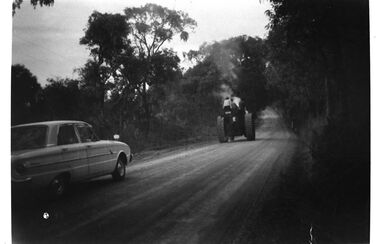 Southern Sherbrooke Historical Society Inc.
Photograph - Steam-driven tractor on Duffys Rd, Narre Warren East
Black and white photo of a steam-driven tractor being driven down Duffys Rd, Narre Warren East. Steam is rising about the tractor. There is at least one other person on the tractor apart from the driver, possibly a woman and a boy. The driver lived further down Duffys Rd. His house was moved prior to work beginning on the Cardinia Reservoir. A sedan is driving behind the tractor. Photo copied from Edna Boothroyd whose family lived on Wellington Rd, Narre Warren East. -
Whitehorse Historical Society Inc.
Article, Green Light Given Roadworks, 12/05/1993
Work started on Eastern Freeway extension just west of Middleborough Road.Work started on Eastern Freeway extension just west of Middleborough Road.Work started on Eastern Freeway extension just west of Middleborough Road.freeways, eastern freeway extension, middleborough road, box hill, baxter, bill, vicroads, springvale road box hill -
 Port Melbourne Historical & Preservation Society
Photograph - Our Lady of Fatima Roman Catholic Church, Nott Street, Port Melbourne, Ron Laing, 1990s
Part of Ron Laing's collection of photographs recording Port Melbourne over a thirteen year period. Donated to the PMH&PS by the photographer.From a set of Ron Laing photographs of Port Melbourne churches, 1990s - 3 of Our Lady of Fatima Roman Catholic Church, Nott Streetreligion - roman catholic church (our lady of fatima), ron laing -
Malmsbury Historical Society
Photograph (Item), Malmsbury Reservoir, Malmsbury ca1990
-
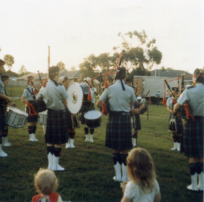 Whitehorse Historical Society Inc.
Photograph, City of Nunawading Pipe Band, 1986
Coloured photo of City of Nunawading Pipe Band - Australia Day.city of nunawading pipe band, australia day -
 University of Melbourne, Burnley Campus Archives
Photograph - Black and white print, Luffmann Ponds
2 photographs of children playing by the Luffmann Ponds. Probably T.H. Kneen's children.children, playing, t.h. kneen -
 Eltham District Historical Society Inc
Photograph - Aerial Photograph, Landata, Eltham, Feb. 1956
Centred on present day Mount Plaeasant Road near Dalton Street, Eltham bounded by Luck Street to north, Eltham Lower Park to south, Reynolds Road to east and Central Park to west Historic Aerial Imagery Source: Landata.vic.gov.au Aerial Photo Details: Project No :250 Project : MELBOURNE OUTER SUBURBS PROJECT Run : 18 Frame : 93 Date : 02/1956 Film Type : B/W Camera : EAG9 Flying Height : 10000 Scale : 12000 Film Number : 1176 GDA2020 : 37°43'02"S, 145°09'38"E MGA2020 : 337871, 5823961 (55) Melways : 22 B6 (ed. 42)aerial photo, 1956-02, neil webster collection, eltham, central park, eltham lower park, luck street, melway 22b6, nyora road, reynolds road, dalton street, mount pleasant road -
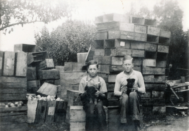 Wonga Park Community Cottage History Group
Photograph (sub-item) - Black and White, Sitting on fruit boxes with our puppies. Ken Heims (right) and Jo Coniglio – c. 1935, c 1935
-
 Whitehorse Historical Society Inc.
Photograph, Forest Hill State School, 1/08/1993 12:00:00 AM
School closed , demolished and land sold for housing .Coloured Photo of Forest Hill State School No. 4251.Springvale Road, Forest Hill. Since demolished. Part of a group of 24.forest hill state school. no. 4251