-
 Federation University Historical Collection
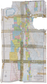
Plan, Plan of the Ballarat and Sebastopol Gold Mines
Coloured plan of the Ballarat and Sebastopol mines. Includes streets. Scale is 1:23,760robert allan, plans, cgt, ballarat, sebastopol, leviathan gold mining company, gold mines, gold companies, gold mining company -
 University of Melbourne, Burnley Campus Archives
Plan, Orchard Plans, 1981
Plans and lists with row numbers and names. (1) Almonds, quinces, figs, peaches, dated 20.02/81. (2) Crabapples, nectarines, peaches, flowering cherries, feijoas, currants and deciduous trees. Bud stock area - Crops (3) Citrus, plums, apricots, apples, pears, almonds, peaches, figs, quinces, medlars. (4) As for (3) but with amendments. (5) Pear Block.fruits, orchards -
Stawell Historical Society Inc
Article - Realia, Glass Window Panel A.W. Whiteside, c1890
Tailors Apparel for Men Location 44 Main Street Stawell Currently AutoproBeveled Glass panes with Gold Leaf, Ornate Initials. A.W. Interwoven with Swag for men's apparel.A W Interwoven, For Men's Apparelshop, business -
 Greensborough Historical Society
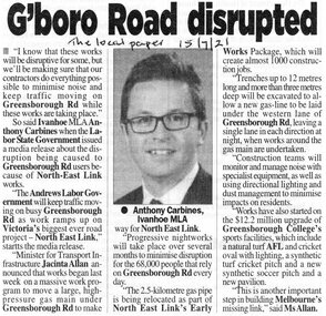
Article - Newspaper Clipping, G'boro Road disrupted, 22/07/2020
Noise and disruption on Greensborough Road will be kept to a minimum, when roadworks for the North East Link Project begin [2021]News clipping, black and white text and image.greensborough road, north east link -
 Mission to Seafarers Victoria
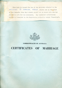
legal record (item) - Register Receipts, Circa 1977
The receipts are dated from the 17th of December 1977 to the 2nd of October 1982. The last receipt has been cancelled. They document some of the information needed on the actual marriage certificate, such as the date and location, bride, bridegroom and celebrant's names, as well as the date the each certificate was sent to registering authority.Part of the record of weddings performed at the Mission to Seafarers between 1977 to 1982.A typed note taped to the front cover: THIS BOOK IS ISSUED FOR USE OF THE MINISTER ATTACHED TO THE / (handwritten) MISSION TO SEAMEN, MELB, (typed) CHURCH AND IN THE EVENT OF HIS TRANSFER FROM THAT CHURCH NOT BY TAKEN WITH HIM BUT / SHOULD BE LEFT FOR HIS SUCCESSOR. ANY CANCELLED CERTIFICATES / SHOULD BE FORWARDED TO THE REGISTERING AUTHORITY MARKED "CANCELLED". Printed under this is the Australian crest. Printed under this: COMMONWEALTH OF AUSTRALIA / CERTIFICATES OF MARRIAGE.marriage, wedding, register, receipt, 1977-1982, mission-to-seafarers, port-melbourne, marriages, dio-marriages, st peter chapel, st andrew chapel -
University of Melbourne, Burnley Campus Archives
Plan, Mary Younger, Proposed Outdoor Eating Area, Student Amenities Block, Vic. College of Agriculture & Horticulture, 1999
Plan of proposed outdoor eating area, Student Amenities Block. Accompanying letter from Mary Younger, Architect, refers to this being a revised drawing and is accompanied by copy (X2) of Australian Standard "Design for access and mobility". AS 1428.1-1998 and 1428.2-1992. See also B18.0006.mary younger, amenities, vcah, burnley -
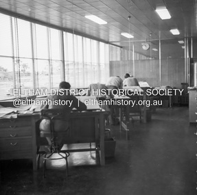
 Eltham District Historical Society Inc
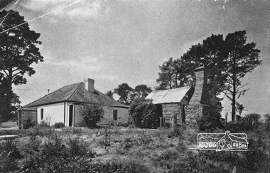
Negative - Photograph, Home Beautiful (United Press), Thomas Sweeney's original cottage at Culla Hill, Eltham, 1940
Feature article in Home Beautiful magazine (c.1940) on the original Sweeney's Cottage at Culla Hill built by Thomas Sweeney, one of the district's pioneer settlersRoll of 35mm black and white negative film, 3 stripsKodak Safety 5062culla hill, eltham, home beautiful magazine, houses, sweeney's cottage, sweeneys lane, thomas sweeney -
 Ballarat Tramway Museum
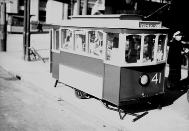
Negative, Wal Jack, Jul. 1944
Yields information about Ballarat 's Treasure tram and fund raising during the second world war.Negative and Digital image of the Wal Jack Ballarat Negative file of the Treasure Tram built for fund raising by the depot staff to support the Most Popular Conductress Competition. See Reg Items 2129 and 5108 for more details. July 1944. Photographed at the corner of Sturt and Lydiard Streets. Image i1, original scan of the negative, image i2, and adjusted scan. trams, tramways, world war i, most popular conductress competition, conductresses, treasure tram, tram 41 -
 Ballarat Tramway Museum
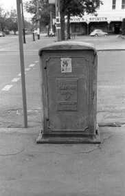
Negative, Wal Jack, 1956?
Yields information about Ballarat tramway electrical distribution of the power supply and the work by ESCo.Negative and Digital images of the Wal Jack Ballarat Negative file of ESCo Electrical Sectioning box at Hospital Corner. In the background is the Herbert's Wine and Spirits store.trams, tramways, hospital corner, electrical engineering, cables, power supply, esco -
 Melbourne Tram Museum
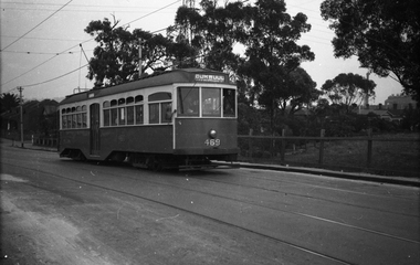
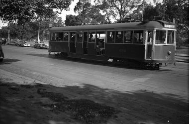
Negative, Wal Jack, c1950
Black and white negative, by Wal Jack, of Y 469 outbound to Burwood in Swan St Richmond with Park Grove in the background. c1950.trams, tramways, swan st, y class, burnley, tram 469 -
 Kew Historical Society Inc
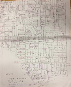
Plan, Gwen McWilliam, Annotated Plan of City of Boroondara, c.1995
Gwen Barton McWilliam (nee: Nelson), OAM, BA (1933- ). Gwen McWilliam is well known as an authority on the history of Boroondara and the author of a large number of books and pamphlets about the City. She was awarded the medal of the Order of Australia in 2001 ‘for service to the community of Hawthorn and district, particularly through the research, documentation and publication of its history.’ Digitally annotated part plan of the City of Boroondara, created by Council (Library?) staff, based on annotated plans provided by the historian Gwen McWilliam, identifying significant landholdings, subdivisions and key dates. On the plan Gwen McWilliam noted that the attempt to copy her annotations had resulted in incorrect data being included, so the plans were never published. For plans including her original 1993 annotations, see 2017.0143 and 2017.0144.Council markings in pinksubdivisions - hawthorn, subdivisions - kew, subdivisions - camberwell, subdivisions - balwyn, subdivisions - surrey hills, subdivisions - canterbury, gwen mcwilliam -
Whitehorse Historical Society Inc.
Article, A Beautiful cultural mix
Louise Multicultural Community Centre teaches English to migrants and is run almost wholly with volunteers.migrant education, louise multicultural community centre, daughters of charity -
Whitehorse Historical Society Inc.
Article, Old and New come together, 1993
Katrina Preschool, Blackburn North, celebrates the school's 25th Anniversary. With photo and caption.Katrina Preschool, Blackburn North, celebrates the school's 25th Anniversary. With photo and caption.Katrina Preschool, Blackburn North, celebrates the school's 25th Anniversary. With photo and caption.child care, katrina preschool, kelly, frances -
Whitehorse Historical Society Inc.
Article, Whitehorse City Council adopts budget 2010/11, 2010
Main points of the City of Whitehorse's budget 2010/11 (photos).Main points of the City of Whitehorse's budget 2010/11 (photos).Main points of the City of Whitehorse's budget 2010/11 (photos).schwerkolt cottage & museum complex, walker, jenny, innes, rob, pemberton, bill, city of whitehorse -
Whitehorse Historical Society Inc.
Article, Diamond wedding, 1972
Article from The Age.Article from The Age re 50th anniversary of the wedding of Edmund & Katrine Fankhauser and a part to celebrate.Article from The Age. fankhauser, edmund, fankhauser, katrine -
Glen Eira Historical Society
Article - Joyous Gard
Two copies of a one page photocopy from the book Australian Sculptors (1980) by Ken Scarlett, describing the Springthorpe Memorial at Boroondara Cemetery, Kew. The file also includes a photocopy of an article by Chrys Spicer, date and source unknown, about the Springthorpe Memorial. The article includes seven photographs of the memorial. A research note by Chloe Stapleton, dated 31/08/12, suggests a possible source for this article. The file also includes a copy of a typed letter from Allan M Doble to Melbourne University Art Curator Heather Lowe, dated 24/03/1995, concerning the history of the Wheel of Life Sculpture originally located at Joyous Gard. The file also includes a copy of a typed letter, dated 19/05/1995, from Allan Doble to the Melbourne University Gallery with information about the Wheel of Life sculpture Also included in the file are photocopies of two Melway maps showing the location of Joyous Gard and Springthorpe Reserve with notes by Allan Doble, dated 24/03/1995. The file also includes eight coloured photographs (100mm x 150mm) of the Wheel of Life sculpture now located in the Medical School of the University of Melbourne, date and photographer unknown, probably 1990s. Negatives are also included.springthorpe memorial, boroondara cemetery, gilbert web c, gilbert webb, the wheel of life, springthorpe john william, inglis annie constance, springthorpe dorothy, springthorpe annie constance, springthorpe enid, springthorpe lancelot, springthorpe guy, joyous gard, doble allan m, doble mrs allan, murrumbeena primary school, springthorpe reserve, joyous gard court, tyers s w, outer circle railway, boyd park, wahroonga crescent, murrumbeena, caulfield city council, boyd’s pottery, linear park -
 Eltham District Historical Society Inc
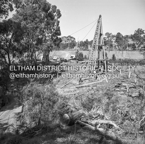
Negative - Photograph, J.A. McDonald, General; Shire Offices, Sep. 1959
Shire of Lilydale, 15 Anderson Street, LilydaleRecord of various Shire of Eltham infrastructure works undertaken during the period of 1952-1962 involving bridge and road reconstruction projects, sometimes with Eltham Shire Council Project Reference numbers quoted. It was during this period that a number of significant improvements were made to roads and new bridges constructed within the shire that remain in place as of present day (2022). In many situations, the photos provide a tangible visible record of infrastructure that existed throughout the early days of the Shire. The album was put together by or under the direction of the Shire Engineer, J.A. McDonald.infrastructure, 1959-09, benchmark studies, lilydale shire office, scan - 120 format 6x6 negative -
 Glen Eira Historical Society
Article - Mayor Jack Campbell 1987-88 (1 of 2)
Various newspaper articlescouncillor, mayor, jack campbell, felicitie campbell, margaret darling, darren overend, kingsley david, labassa -
University of Melbourne, Burnley Campus Archives
Plan, Horticultural Project Conservation and Management Plan Wombat Park, c. 1990
Photocopies of plan drawn by M. Gilbert of Survey Area C-G, with numbered plant list.m. gilbert, wombat park, management plan -
 Whitehorse Historical Society Inc.
Legal record - Report, Land Sale, 01/10/1855
Report of land sale by public auction, Parish of Nunawading, October 1855Report of land sale by public auction, Parish of Nunawading, October 1855Report of land sale by public auction, Parish of Nunawading, October 1855riley, patrick, holland, john, lobb, land sales -
 Kew Historical Society Inc
Plan - Subdivision Plan, Wimba Estate, Kew, c.1925-c.1929, ca. 1925-ca. 1929
Pru Sanderson, in her groundbreaking ‘City of Kew Urban Conservation Study : Volume 2 - Development History’ (1988), summarised the periods of urban development and subdivisions of land in Kew. The periods that she identified included 1845-1880, 1880-1893, 1893-1921, 1921-1933, 1933-1943, and Post-War Development. These periods were selected as they represented periods of rapid growth or decline in urban development. An obvious starting point for Sanderson’s groupings involved population growth and the associated economic cycles. These cycles also highlighted urban expansion onto land that was predominantly rural, although in other cases it represented the decline and breakup of large estates. A number of the plans in the Kew Historical Society’s collection can also be found in other collections, such as those of the State Library of Victoria and the Boroondara Library Service. A number are however unique to the collection.Subdivision plans are historically important documents used as evidence of the growth of suburbs in Australia. They frequently provide information about when the land was sold on which a built structure was subsequently constructed as well as evidence relating to surveyors and real estate and financial agents. The numerous subdivision plans in the Kew Historical Society's collection represent working documents, ranging from the initial sketches made in planning a subdivision to printed plans on which auctioneers or agents listed the prices for which individual lots were sold. In a number of cases, the reverse of a subdivision plan in the collection includes a photograph of a house that was also for sale by the agent. These photographs provide significant heritage information relating house design and decoration, fencing and household gardens.In 1925, the City of Kew called for tenders for the construction of Wimba Avenue, Cadow Street and Lalla Street. Subsequent advertisements for the sale of land in Wimba Avenue continued from 1926 to 1929. The 18 lots (and a further five allotments on the eastern side of the street) offered for sale were unofficially described in the subdivision plan as the ‘Wimba Estate’. These lots began in Park Hill Road and extended almost to Cotham Road. The subdivision took its name from the house ‘Wimba’ in Cotham Road, which may have formed the southern boundary of the subdivision. (Wimba, at 235 Cotham Road was constructed between 1862-70). The Plan highlights the proximity and advantage of ‘electric’ trams in Cotham and Glenferrie Roads, and the Kew and Glenferrie Railway Stations. An oddity in the Plan is the reference to the electric tram terminus at Burke Road, given that the tramline had already been extended to Mont Albert in 1916.wimba estate, subdivision plans - kew, parkhill road – kew (vic.), normanby road – kew (vic.), wimba avenue – kew (vic.) -
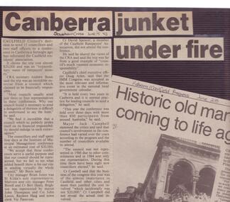
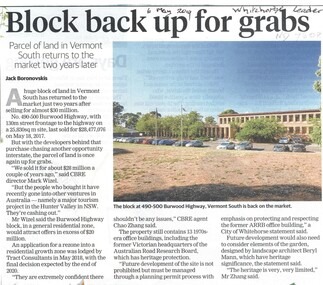 Whitehorse Historical Society Inc.
Article, Block Back Up For Grabs, 2019
No. 490 - 500 Burwood Highway, Vermont South is for sale again after selling for almost $30 million two years ago. Heritage protection applies to the building and garden.No. 490 - 500 Burwood Highway, Vermont South is for sale again after selling for almost $30 million two years ago. Heritage protection applies to the building and garden.No. 490 - 500 Burwood Highway, Vermont South is for sale again after selling for almost $30 million two years ago. Heritage protection applies to the building and garden.burwood highway, vermont south, no. 490 - 500, land sales -
 Whitehorse Historical Society Inc.
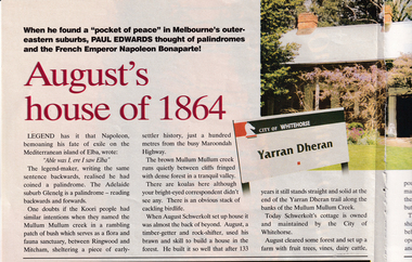
Article, August's house of 1864, 01/12/1997
Article on Schwerkolt's Cottage and Mullum Mullum Creek in the R.A.C.V. Journal 'Royal Auto' briefly covering history and location. 2 pages. Coloured photo.schwerkolt, johann august, schwerkolt cottage, city of whitehorse, yarran dheran -
Whitehorse Historical Society Inc.
Article, Heather's last day at school
Heather White, Principal of Springview Primary School retires. With photo.primary schools, white, heather, springview primary school, blackburn north -
 Melbourne Tram Museum
Negative, Wal Jack, 10/02/1941 12:00:00 AM
Black and white negative, by Wal Jack, of No.CW5 684 Batman Ave on its way to Burwood. Has the Yarra River and the Gardens in the background. The tram is well loaded. Photo dated 10-2-1941 in the Wal Jack album along with details of the location.trams, tramways, batman ave, cw5 class, burwood, tram 684, route 74, mmtb -
Ringwood and District Historical Society
Legal record - Conditions of Sale (C.E.Carter), Warrandyte, Lot (?) on Plan of Subdivision (?), Mr W.E.Aird and (?), Circa 1930
Particulars and Conditions of Sale of Property , from Mr W.E.Aird to (?) -
 Eltham District Historical Society Inc
Negative - Photograph, J.A. McDonald, Laidlays Road, Arthurs Creek, April 1962
Bridge over Arthurs Creek Looking east April 1962Record of various Shire of Eltham infrastructure works undertaken during the period of 1952-1962 involving bridge and road reconstruction projects, sometimes with Eltham Shire Council Project Reference numbers quoted. It was during this period that a number of significant improvements were made to roads and new bridges constructed within the shire that remain in place as of present day (2022). In many situations, the photos provide a tangible visible record of infrastructure that existed throughout the early days of the Shire. The album was put together by or under the direction of the Shire Engineer, J.A. McDonald.1962-04, arthurs creek, bridge construction, infrastructure, laidlays road, shire of eltham -
 Queenscliffe Maritime Museum
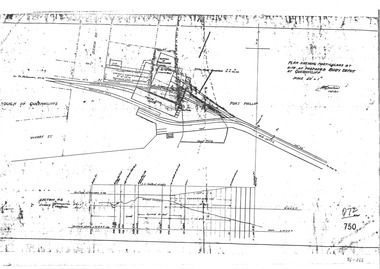
Plan - Proposed buoy depot at Queenscliffe 14/9/1926, Government Works plan of buoy depot proposal, 1926
Queenscliffe buoy depot locationHistorical details of proposed buoy depotphotocopy of a plan showing proposed buoy depot location 1926Reverse " NIL ".historical references -
Glenelg Shire Council Cultural Collection
Negative - Negative - Nun's Beach, Portland, c. 1934
NEGATIVE FOR BLACK AND WHITE PHOTOGRAPH. View taken from Nun's Beach looking towards Whaler's Bluff.negative, south west coastline, portland, nuns beach -
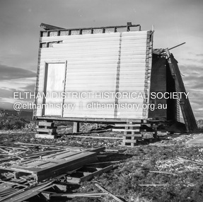 Eltham District Historical Society Inc
Negative - Photograph, J.A. McDonald, Inspection of storm damaged Abraham house at Kangaroo Ground, c. May 1962
Showing the effect of a wind storm that destroyed the house circa May 1962.. The Abraham family owned land near the Aqueduct and east of Nicholas Lane at Kangaroo Ground (based on photos, at or near 40 Nicholas Lane).Record of various Shire of Eltham infrastructure works undertaken during the period of 1952-1962 involving bridge and road reconstruction projects, sometimes with Eltham Shire Council Project Reference numbers quoted. It was during this period that a number of significant improvements were made to roads and new bridges constructed within the shire that remain in place as of present day (2022). In many situations, the photos provide a tangible visible record of infrastructure that existed throughout the early days of the Shire. The album was put together by or under the direction of the Shire Engineer, J.A. McDonald.1962-05, abraham house, kangaroo ground, nicholas lane, property damage, storm damage