-
 Moorabbin Air Museum
Photograph (Item) - (SP) RFDS Royal Flying Doctor Service Series of photographs of aircraft flown
-
 Lara RSL Sub Branch
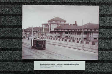
Photograph - Post World War 1 Photographs of Hospitals, Geelong and District Hospital 1909-12, Mont Park Hospital, Randwick Military Hospital 1919
Returning wounded soldiers from World War 1 and hospital information,Hospital ans patient data for 918-1919Photos of Geelong Hospital 1/ dated 1909-1912 2/ Dated 1930, 3/ Mont Park Hospital dated 1918, 4/ Randwick Military Hospital Sydney dated 1919Photos also come with notation padsgeelong hospital, mont park hospital, randwick military hospital -
 Bendigo Historical Society Inc.
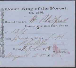
Document - ANCIENT ORDER OF FORESTERS NO. 3770 COLLECTION: RECEIPT
Blue paper headed Court King of the Forest, No. 3770 A.O.F, B.U.D., dated Aug 25 1875. Received from Bro. W. Philpot, Treasurer of the above Court, the sum of 13/6 being 4 day's sick pay for Bro. J. H. Phillips. Signed by R. ? Coath.societies, aof, correspondence, ancient order of foresters no. 3770 collection - receipt, w philpot, j h phillips, r coath -
 Bendigo Historical Society Inc.
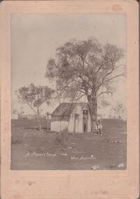
Photograph - A MINER'S CAMP WEST AUSTRALIA
Black and white photograph of a miner's camp in West Australia. The relevance of this photo is on the written note on the back: Annie Agnes Skeats (nee Martin) first marriage to Mr.Skeats, second marriage to Mr. Montgomerie her daughter Elsie married Tasman Andrew from Andrew Auctions Room.photograph, landscape, west australia -
Bendigo Historical Society Inc.
Photograph - BENDIGO SHOWGROUNDS
Aerial black and white photograph of the Bendigo showgrounds. Date unknown. There is a sticker 'you are now here at the stand of Frank A. Hill & co. Several of the pavilion are named: horses (x4), cattle, pigs, Lansell Hall, sheep, wool, dogs, poultry booth, sideshows, centre hall, park road hall and luncheon.bendigo, streetscape, showgrounds -
 Melbourne Tram Museum
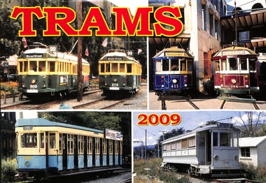
Document - Calendar, Topmill Pty Ltd, "Trams 2009"
Contains full colour photographs of Melbourne trams in other locations such as Edmonton, Auckland, Christchurch, Seattle, Memphis, New Orleans, San Francisco, Denmark, San Jose, and Dallas. Also contains photographs of Adelaide, Brooks Oregon, Kennebunkport, Okayama, Demonstrates production of calendars featuring tram photographs, containing many historic photographs and Melbourne Ws in overseas places.Wall Calendar - heavy card covers, 28 gloss art pages inside, titled "Trams - 2009" with a punched hole along the top edge to enable wall use.tramways, melbourne, adelaide, san francsico, w2 class, sw 6 class, edmondton, denmark -
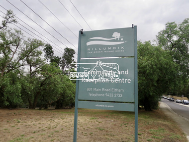 Eltham District Historical Society Inc
Photograph, Jim Connor, Main Road, Eltham, 14 Jan 2017
Eltham Gateway, Eltham Community and Reception Centre, 801 Main Road, ElthamTomorrow's history documented todayeltham, jim connor collection, main road, eltham gateway, eltham community and reception centre -
University of Melbourne, Burnley Campus Archives
Photograph - Black and white print, 395/14A
Magnolia in front of Principal's Residencemagnolia, principal's residence, e. m. gibson collection -
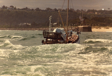 Lakes Entrance Regional Historical Society (operating as Lakes Entrance History Centre & Museum)
Photograph, 1980c
May be 'Lady Jane'Colour photograph of an unidentified scallop fishing boat approaching the entrance channel after crossing the bar. Boat has bags of scallops stacked neatly on deck. Photograph taken from boat following. Lakes Entrance Victoriafishing industry, ships and shipping, waterways, ocean -
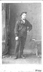 Queenscliffe Maritime Museum
Photograph, Photographer unknown
Undated black & white photo of the lifeboat sailor in Scotland.RealismMrs D BeavisBlack & white photo of a lifeboat sailor from ScotlandOn the reverse - 'year 1890?', 'one of the lifeboat crew', 'duplicate may be had any time' - Wm McLeod, 20 Keith St Stornoway'.lifeboat, boat crew, sailor, uniform -
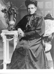 Stawell Historical Society Inc
Photograph, Mrs Elizabeth Anne Pearce nee Knuckey 1840-1911 -- Studio Portrait
Portrait - Elizabeth Anne Pearce (Nee Knuckey) 1840-1911stawell -
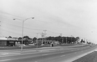 Ringwood and District Historical Society
Photograph, Maroondah Highway East, Ringwood- 1969. Looking west towards Ringwood from Burnt Bridge area
Black and white photographNil -
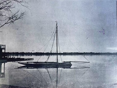 City of Ballarat Libraries
Photograph - Card Box Photographs, Yacht with sails down on a calm Lake Wendouree
lake wendouree, yacht, vehicle -
Whitehorse Historical Society Inc.
Document, James Alfred Turner Greeting Card, n.d
Greeting card of a painting by James Alfred Turner.Greeting card of a painting by James Alfred Turner. This painting was also used on the cover of the pamphlet ND5885 'The Story of James Alfred TurnerGreeting card of a painting by James Alfred Turner. turner, james alfred -
 Lakes Entrance Regional Historical Society (operating as Lakes Entrance History Centre & Museum)
Photograph, 1952
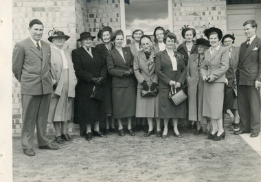
Black and white photograph of Greg Ridsdale, Alex Bain Tambo Shire, Del Richey, Joyce McColley, Ethel Bulmer, Dr Meredith, Evelyn May, Hazel Bulmer, Mavis Smith, Mrs Chris Freeman, Mrs Freddie Moore, Mrs Remington. Two names unknown, standing at the front of the Infant Welfare Centre at the opening ceremony. Lakes Entrance Victoriacharities, volunteering -
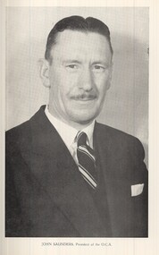 St Patrick's Old Collegians Association (SPOCA)
Photograph - SPOCA, Presidents
-
 National Vietnam Veterans Museum (NVVM)
Photograph, Photocopy
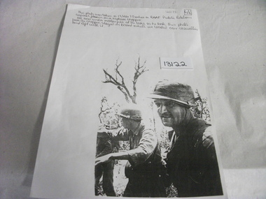
Photocopy of a Photograph taken from Medivac Chopper of two soldiers, one Australian Soldier and one South Vietnamese Soldier. Notation on top of photocopy telling of event.photograph, document, medivac, soldiers -
 Department of Health and Human Services
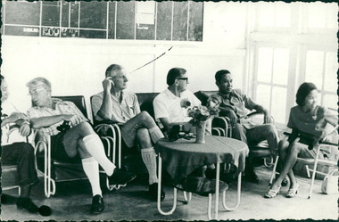
Photograph, Officials and medical staff and Australian contingent in informal discussions & settings inside the Hospital, MacFarlane Burnet 2nd from left, Dr Forbes 4th from left - Dr John A Forbes Fairfield / Gull Force 2/21 Bn AIF / Ziarah Caltex & Rumah Sakit Ambon Hospital - Photo is from Dr John Forbes photo albums - 1971
Department of Health & Human Services - Dr John A Forbes Fairfield / Gull Force 2/21 Bn AIF / Ziarah Caltex & Rumah Sakit Ambon Hospital Indonesia CollectionDepartment of Health & Human Services - Dr John A Forbes Fairfield / Gull Force 2/21 Bn AIF / Ziarah Caltex & Rumah Sakit Ambon Hospital Indonesia Collection -
University of Melbourne, Burnley Campus Archives
Document - Handbook, Victorian College of Agriculture and Horticulture, Victorian College of Agriculture & Horticulture Burnley, 1983-1984
handbook, vcah, victorian college of agriculture and horticulture, students, courses -
Glenelg Shire Council Cultural Collection
Document - Document - Specifications 12" MS Welded pipelines, n.d
Port of Portland Authority Archivesport of portland archives -
 Bendigo Historical Society Inc.
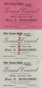
Document - CONCERT TICKET, TOWN HALL BENDIGO, MISS E. MORCOMBE SOPRANO
3 tickets, (identical text, one pink 2 blue) for E. Morcombe Concert. On front: 'The Town Hall, Bendigo, Grand Concert under distinguished patronage. Friday 16th July, 1909, Miss E. Morcombe, the gifted 'Bendigonian Soprano' assisted by leading artists. Front Seats 2/-. Mrs E. Mueller, W.J. Parry, Director.entertainment, concert, miss e morcombe -
 Ballarat Heritage Services
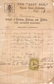
Document - Image, Invoice The "Busy Bee", Vincent Street, Daylesford, 1904, 21/12/1904
Invoice from Hattam, Hattam and Mellor, drapers of Vincent Street, Daylesford.luigi gervasoni, philately, daylesford, vincent street, daylesford, busy bee, invoice, hattam, hattam and mellor, draper -
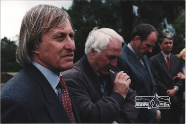 Eltham District Historical Society Inc
Photograph, L-R: Nillumbik Shire President Robert Marshall with architects Graeme Gunn and Ian Jelbart at the launch of the Kinloch Gardens development, 93 Arthur Street, Eltham, April 1998, April 1998
Launch of the Kinloch Gardens development, 12 new double and triple storey homes along a private road in the gardens of Kinloch, a mansion set on 2.4ha in Arthur St. The launch was attended by Planning Minister Rob Maclellan and Nillumbik Shire president Robert Marshall, Architects Graeme Gunn and Ian Jelbart and approximately 100 guests.3 images; digital file only; created from scan undertaken by EDHS of a set of 30 colour 10 x 15 cm prints arthur street, eltham, graeme gunn, houses, ian jelbart, jelbart property, kinloch gardens, robert marshall, woodridge estate -
Lakes Entrance Regional Historical Society (operating as Lakes Entrance History Centre & Museum)
Photograph, Lakes Post Newspaper, 1/05/1991 12:00:00 AM
Black and white photograph showing Frank Guarnaccia, Bruce Evans and Cr Judith Henderson at reception for National Party State Leader Pat McNamara at Shire of Tambo Palmers Road Lakes Entrance Victoriaaustralia day, celebration -
 Eltham District Historical Society Inc
Photograph, Peter Pidgeon, Main Road, Eltham, 2 Aug. 2022
Comparison photo: SEPP_0707 and SEPP_0618 Part of a presentation by Peter Pidgeon to the Society, 13 August 2022 showcasing a series of photographs taken by John Henry Clark over the period 1895 to 1930. John Henry Clark was the youngest of three boys born to William Henry Clark (1823-1877) and Maria White (1843-1914). He and his brothers, William Charles Clark (1872-1945), Clement Kent Clark (1874-1912) operated a photography business (Clark Bros.) from 25 Thomas Street, Windsor near Prahran during the period c.1894 to 1914. Following death of Clement in September 1912 and their mother in 1914, the Clark Bros business appears to have dissolved, the premises demolished, and a new house was under construction in 1915. John set up business independently in 1914 operating out of 29 Moor Street, Fitzroy where he is registered in the 1914 and 1915 Electoral Rolls. By 1916 John had relocated to Eltham where he continued his practice as a photographer and took many of the early images around the district of Little Eltham. Around 1930 John changed professions and opened a small cobbler's shop in 1931 near the pond opposite Dalton Street adjacent to the Jarrold family cottage. He never married and continued his profession as a bootmaker from this little shop, maintaining a close relationship with Mrs Jarrold for the rest of their lives. His bootmaker shop remains today beside the Whitecloud cottage and is one of only three remaining shops in the area from the early 20th century.Comparative photo taken 2022 with one taken from same location over 100 years earlier by noted local photographer J.H. ClarkBorn Digitaleltham, j.h. clark photo (2022), main road -
 Federation University Art Collection
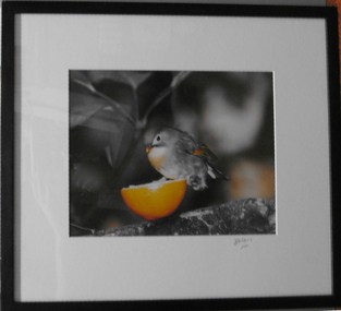
Photograph, Frank Golding, 'Three-quarter Time' - by Frank Golding, 2001
Frank Patrick Golding (1938 - ) This item is part of the Federation University Art Collection. The Art Collection features over 1000 works and was listed as a 'Ballarat Treasure' in 2007. Frank Golding is an author, researcher, historian, consultant: Honorary Senior Research Fellow at Federation University in Victoria, Australia. His formal qualifications are TPTC (Ballarat), BA (Melb), BEd (Melb), Dip MT (UNE), MA (Hons) (London). He has taught English and History in several schools. Frank Golding was employed as Principal at three schools including a multi-site English language centre for refugees and other new arrivals. Later he taught in and managed curriculum and equity programs in education departments and universities. Finally he is the author of 12 published books including a memoir, An Orphan’s Escape: Memories of a Lost Childhood (Lothian, 2005) which describes his childhood as a Ward of the State of Victoria in the ‘care’ of three foster mothers and three institutions. Golding lived in the Ballarat Orphanage from 1943 to 1953. It is his childhood experiences that underpin Golding's active involvement in ‘care’ leaver issues as an advocate and lobbyist. Golding is a Life Member of CLAN (Care Leavers of Australasia Network) the peak body of Care Leavers for Care leavers run by Care Leavers.Image of bird on 1/2 orange citrus fruit - a play on childhood memory of oranges at 3/4 timeSignature on label on backart, artwork, frank golding, bird, federation college, photography, colour photography, alumni -
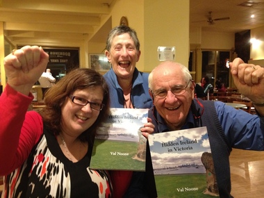 Ballarat Heritage Services
Photograph - Photograph - Colour, Clare Gervasoni, "Hidden Ireland" Hot of the Press
Photograph of "Hidden Ireland' author Val Noone (right), Mary Doyle (centre) and Lisa Gervasoni (left) holding a photo of the book 'hot of the press'.val noone, mary doyle, lisa gervasoni, hidden ireland -
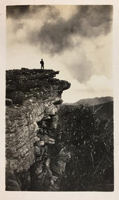 Kew Historical Society Inc
Photograph - Grampians, 1924
Henry Beater Christian (1886-1962) , was a descendant of one of the earliest settler families in Kew. Employed at the Kew Asylum as a 'public servant', he was a skilled amateur photographer, photographing numerous scenes in Kew and on his travels around Victoria. The majority of his photographs date from 1916 to 1929. His finest photographs are housed in two photograph albums. Digital copy of a photograph from page 12 of the 47-page photograph album containing 261 gelatinous silver images, loaned by Diane Washfold with permission given to digitise and hold a copy in our collection. The first and last pages in the album document the Yarra River at Studley Park and at Kew. The remainder of the album includes photographs of walking and car tours in rural Victoria including 'wilderness' areas in the Grampians, Gippsland and the High Country. Six album pages document a camping trip by Henry Christian to the Grampians in September 1924. The photos include pictures of lookouts, and natural features including rock faces and waterfalls, as well as his camp site. This photo is of a man, perhaps Henry Christian, standing on one of the lookouts on what is probably the Mt Victory trail. "Mt Victory / Grampians / 9.24"henry beater christian (1886-1962), landscape photography, christian-washfold collection, photograph albums, grampians, mt victory, gariwerd -
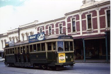 Ballarat Tramway Museum
Photograph - Black & White Photograph/s - set of 3, Ron Hann, 26/12/1959 12:00:00 AM
Yields information about the principal intersection following the opening of electric trams, with an electric tram in photo and prior to a parade.Colour prints on laser print paper - of Bendigo 2 climbing the hill in View St Bendigo, 26/12/1959 enroute to Eaglehawk. Show streetscape, centre poles and buildings. The tram has a Cohn's drink ad on the front panel and two roof advertisements for Admiral Televisions and the destination of Eaglehawk. Printed on Fujifilm, Fujicolor Crystal Archive for Frontier"Has labels "References T3116, T3117 and T3118 Photo by Ron Hann" and another label "Bendigo 26.12.59" on rear.trams, tramways, view st, bendigo, tram 2 -
 Ringwood and District Historical Society
Photograph, 5 children of Florence Cutts (married to William Lowen), L-R ,Leonard, Osborne, Harold, Edith (married Ben Hussey), Gladys. (Refer also EM00019)
Colour photographNil