-
 Bendigo Military Museum
Literary work - DIARY, Post August 1942
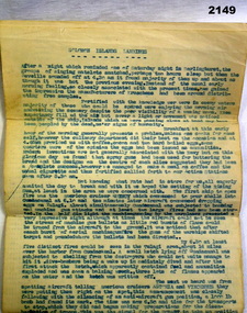
Arthur George Holley No 13556 RAN HMAS Hobart. This is the 3rd part of a diary relating to 2147. Refer also 2134 for service history, 2135.3, 2137. Diary, A.G Holley RAN. Seven page typed in blue ink with heading "Solomon Islands Landings" which began on 7th August 1942. There are no clear dates, detailed account of the action.diaries, naval, personal -
 Stawell Historical Society Inc
Map, Stawell Gold Mine, Plan Showing Wonga Pit and Underground Development, August 2001
Stawell Gold Mines Victoria Scale 1 : 2500mining, gold -
Glenelg Shire Council Cultural Collection
Negative - Glass Plate Negative - Botanic Gardens, c. 1890
Glass plate negative. Image shows 3 young women on bridge in Botanic Gardens - one of the bridges linking the islands. Dress estimated to be late 19th, early 20th Century. -
Bendigo Historical Society Inc.
Negative - CASTLEMAINE GAS COMPANY COLLECTION: NEGATIVES
8 strips of negatives in plastic pocket. These have not been scanned.negative, bendigo, gas and fuel -
Stawell Historical Society Inc
Map, Three Jacks Mine 1920, 1920
Three Jacks Mine 1920stawell, mining -
 Kew Historical Society Inc
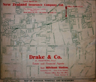
Map - Street Map, R L Jarrett, Map of Mitcham, Tunstall and Blackburn, 1929
Tunstall was originally the name of Nunawading Railway Station. Tunstall opened on 4 June 1888 and was renamed on 1 November 1945. An historically significant advertising map that can be used to ascertain the extent of urban development in 1929 in the areas of Nunawading, Blackburn and Mitcham.A map of Mitcham, Tunstall and Blackburn found on the reverse of a real estate subdivision plan published by R. L. Jarrett of Elizabeth Street. This promotional street map is overprinted with the business address of the sponsors and advertising. Map overlaid in red print: "Drake & Co. / (N. Armstrong, Prop.) / Estate and Financial Agents / next Mitcham Station / Established 1914. Open all day Saturday. / Phones: Office, Box Hill 289 J. / Private, Vermont 10."real estate agents, mitcham, tunstall, blackburn, road maps, drake & co, new zealand insurance co ltd -
 Melbourne Tram Museum
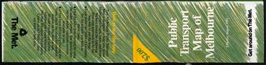
Map, The Met, Public Transport Map of Melbourne - Get around on The Met, 8/1989
Melbourne transport map - dated August 1989 - zone ticket system, has a photo of the front of B2 2004, includes a map of the ticket zones, and The Met contact details.Yields information about Melbourne public transport services in August 1989.Fold out map (36 sections 9 across x 4 deep), "Public Transport Map of Melbourne", coloured of Melbourne's Tram and Bus routes, route numbers, rail lines, detailed for the central part of Melbourne and the outer Metropolitan services.tramways, melbourne, tram services, bus services, railways, maps, zones -
 Wodonga & District Historical Society Inc
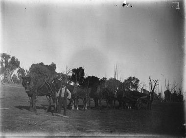
Negative - Haeusler Glass Negatives Collection - Horse team and wagon with owner, c1910
The Wodonga Historical Society Haeusler Collection provides invaluable insight into life in late nineteenth and early twentieth century north east Victoria. The collection comprises manuscripts, personal artefacts used by the Haeusler family on their farm in Wodonga, and a set of glass negatives which offer a unique visual snapshot of the domestic and social lives of the Haeusler family and local Wodonga community. This digital image was produced from one of the glass negatives that form part of the collection, probably taken by Louis Haeusler (b.1887) with the photographic equipment in the Wodonga Historical Society Haeusler Collection. This item is unique and has well documented provenance and a known owner. It forms part of a significant and representative historical collection which reflects the local history of Wodonga. It contributes to our understanding of domestic and family life in early twentieth century Wodonga, as well as providing interpretative capacity for themes including local history and social history.Digital image created from the Haeusler Glass negative collection. A team of horses and a wagon, possibly owned by Joe Silvawodonga pioneers, haeusler family, glass negatives, dry plate photography, joe silva wodonga -
Port Melbourne Historical & Preservation Society
Map - Lagoon and beach, Sandridge, Borough of Sandridge, 1870
Map of Lagoon and beach with soundings, 1870.Signed by Chas. Clay, Borough Surveyor, Sandridge.charles clay, sandridge lagoon -
 Eltham District Historical Society Inc
Negative - Photograph, Art show, Eltham Community Centre, c.1994
Art show held in the Eltham Community CentreRoll of 35mm colour negative film, 1 stripKodak Gold 100-4art exhibition, eltham community centre -
Bendigo Historical Society Inc.
Map - SANDHURST SHEET 2, 14/03/1923 ?
Map: Sandhurst sheet 2. Parish planmap, bendigo, parish plan, sandhurst -
 Ballarat Tramway Museum
Negative - Set of 2, Geoff Grant, 7/05/1955 12:00:00 AM
Negatives No. 284 and N285 and colour print made by colour laser printer (stored in folder ) of Y1 613 in Camberwell depot entry or existing area 7/5/1955. Photo by Geoff Grant. Hi res scan of negative and image updated 19/5/2020.trams, tramways, melbourne, camberwell depot, tram y 613 -
Glenelg Shire Council Cultural Collection
Negative - Negative - Lee Breakwater under construction Portland, Victoria, Zilah Maschmedt, 1961
Negative for a black and white photograph. Image shows Lee Breakwater (SL Patterson) under construction, taken near old baths, Whaler's Bluff in background. -
 Federation University Historical Collection
Negative - Object, Lantern Slides, pre 1914
The Gurley enterprise was established in 1845, first as the partnership of Phelps & Gurley and in 1852 as W. & L. E. Gurley. William Gurley and his younger brother Lewis E. were both engineering alumni of Rensselaer Polytechnic Institute, in Troy, NY, and brought to the business a hunger for technical innovation and unrivaled marketing skill. Exposure at the Centennial Exposition in 1876 launched the company into international prominence from which it never fell. The brothers built a factory in 1852 that operated in departments, each department turning out different components, which were then assembled. This revolutionized the industry which, to that time, operated as small shops making, essentially, individual instruments. Gurley was able to roughly halve the price of their instruments over those of their competition, while maintaining quality. (https://www.gurley.com/history)A timber box of 30 lantern Slides.astronomy, lantern slides, gunn's, w. & l.e. gurley -
Bendigo Historical Society Inc.
Map - CAMPBELL COLLECTION: BENDIGO AND DISTRICT MAPS
Map. Eaglehawk, Parishes of Huntly and Nerring. Scale 20 chains to 1 inch. Total area 6211 acres. Eaglehawk Kerang Railway, to Epsom 2 miles. Manure Depot. (number 390 in map cupboard 1)map, bendigo, allotments -
Bendigo Historical Society Inc.
Map - RAVENSWOOD, April 6th 1872
Map: Township of Ravenswood. Parish plan, has a 1913 calendar as a backing (number 266 in map cupboard 1)map, bendigo, township, ravenswood -
Canterbury History Group
Map - Canterbury. Sale of the season, c1929
Photocopy of sale notice for 28 mansion and villa sites in area bordered by Kent Avenue, Mont Albert Road, Faversham and Chatham Roads 29 September [1929]canterbury, mont albert road, faversham road, kent avenue, chatham road, flere & co, land subdivision, auctions -
Bendigo Historical Society Inc.
Map - NEW CHUM LINE, 1875
Plan: Longtitudinal section of the Southern Section of the New Chum Line of Reef. Compilation consisting of small sections stapled togetherCALEB THOMAS 1875map, mining plan, gold mines, new chum line -
 Northern District School of Nursing. Managed by Bendigo Historical Society Inc.
Education kit - Yellow Canaries Nursing Uniform 1972 - 1986. Nursing through the Ages
In 1972 Designed Noeline King designed a new uniform for the Northern District School of Nursing. Yellow and White dress with a yellow jacket. 1st worn by School 80 (31/07/1972) Students nurses wore this distinctive uniform in wards and were affectionately known as "Yellow Canaries"The Uniform was worn to the forced school closure in July 1989 as a result of transfer of nursing education into Colleges of Advanced Education. School 108 (4/8/1986) was the final school. 30cm Miniature Doll - Yellow and white dress with yellow jacketName Tagnursing history, nursing uniforms, northern district school of nursing -
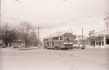
 Ballarat Tramway Museum
Negative - Set of 3, Geoff Grant, 7/04/1956 12:00:00 AM
Negatives No. N361 to 363 and black and white prints made by a laser printer (stored in folder ) of AETA tour (Australian Electric Traction Association) on 7/4/1956 of the new East Brunswick, Blyth St. route. 1620.1 - W7 1033 at the Blyth St. terminus 1620.1 - W7 1033 at North Fitzroy tram depot 1620.1 - W7 1033 and SW6 957 at the Spencer St. terminus in Bourke St with the MMTB tramway buildings in the background and Carlyon's Hotel along side. hi res scan made and image updated 23/5/2020.trams, tramways, melbourne, bourke st, spencer st, aeta tour, east brunswick, north fitzroy depot, tram 1033 -
Canterbury History Group
Map - Victorian Railways, Canterbury, Drainage Plan, cc1910
Drainage plan around Canterbury Station, Canterbury Road and Maling Road .5 pages of photocopies from the Public Record Officecanterbury, canterbury road, maling road, canterbury station, drainage, stormwater channels -
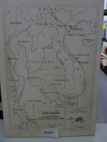 National Vietnam Veterans Museum (NVVM)
Map, Vietnam in Continental Southeast Asia 1965, 1965
Mounted black and white map of Southeast Asia with country borders and major cities marked. There is a highlight of Phuc Tuy Province in the lower righthand cornerCountries, cities and gulfs anotated map title - Vietnam in Continental Southeast Asia 1965map, phuc tuy -
Moorabbin Air Museum
Map (Item) - Map of Port Melbourne & Coode Island Rifle Range circa 1950s-60s
-
Glenelg Shire Council Cultural Collection
Negative - Negative - View of Nelson, 1934
Zillah Maschmedt took a series of photographs of Portland and the surrounds in 1934. She was a school teacher from South Australia.Negative for black and white photo. View of Nelson from Glenelg River, bridge over river visible.photography, zillah maschmedt -
Warrnambool and District Historical Society Inc.
Financial record - Dockets (two), John Hyland et al, 1897
These two 1897 dockets are from the Warrnambool auctioneers, John Hyland and Archibald Macfarlane. They refer to the sale by auction of the material from the demolition of the temporary buildings erected at the corner of Timor and Liebig Streets in Warrnambool as part of the staging of the Warrnambool Industrial and Art Exhibition, 1896-7. This exhibition, a major event in Warrnambool's history, ran from December 1896 to March 1897 and according to the press reports at the time attracted over 70,000 people to its many exhibitions, competitions and entertainments. Despite its popularity the Exhibition ran at a financial loss and the sale of the material from the temporary buildings was an attempt to recoup some of the losses. The sale of the timber, iron, glass etc from the temporary buildings returned about one-third of the original cost of the buildings. A feature of the John Hyland docket is the payment of seven shillings and sixpence to Ballis the bellman for ringing his bell and vocally advertising the sale in the town. These two dockets are of considerable interest as they add to our knowledge of the Warrnambool Industrial and Art Exhibition, an important event in our local 19th century history.1 and .2 These are two dockets printed on white paper with ruled red lines.The headings are printed and the details of sales are handwritten in black ink.19th century warrnambool auctioneers, warrnambool industrial and art exhibition 1896-7 -
 Ballarat Tramway Museum
Negative - Set of 10, Campbell Duncan, 10/08/1971 12:00:00 AM
Yields information about tram operations and the street views at Hospital Corner.Set of 10 photographs taken on 10/8/1971 by Campbell Duncan of trams at Hospital Corner. .1 - No. 35 turning from Sturt into Drummond St South heading for Sebastopol. .2 - No. 31 inbound to Mt Pleasant with Hospital in background. Tram has two Johnny Walker whiskey roof adverts. .3 - No. 27 turning from Sturt St into Drummond St North, to the Gardens. Has the Mobil Service station and other buildings in the background and the ESCo street pillar. .4 - No. 43 turning from Drummond St South into Sturt St with the Southern Cross Hotel etc in the background. .5 - ditto - side on view. .6 - No. 39 and a single trucker on the north side of Sturt St - No. 39 has arrived from the depot via Sturt St west and about to turn to run to Grey St. .7 - ditto .8 - ditto .9 - ditto .10 - No. 39 crossing Sturt St in Drummond St.trams, tramways, hospital corner, drummond st, sturt st, electrical equipment, tram 35 tram 39 tram 31 tram 27 tram 43 -
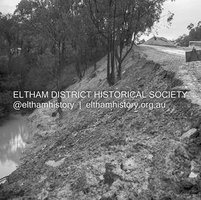 Eltham District Historical Society Inc
Negative - Photograph, J.A. McDonald, Heidelberg-Kinglake Road, Sep 1959
Job 56M430 Contractor Hone Wash over road due to blocked table drain caused this wash out on embankmentRecord of various Shire of Eltham infrastructure works undertaken during the period of 1952-1962 involving bridge and road reconstruction projects, sometimes with Eltham Shire Council Project Reference numbers quoted. It was during this period that a number of significant improvements were made to roads and new bridges constructed within the shire that remain in place as of present day (2022). In many situations, the photos provide a tangible visible record of infrastructure that existed throughout the early days of the Shire. The album was put together by or under the direction of the Shire Engineer, J.A. McDonald.infrastructure, shire of eltham, bridge construction, 1959-09, heidelberg-kinglake road, road construction -
Glenelg Shire Council Cultural Collection
Negative - Negative - Nelson, Victoria, c. 1936
Transparency for black and white photo. Bush tracks at Nelson. Nelson - Mt Gambier mail truck and man standing beside it, in bush setting. -
 Bendigo Historical Society Inc.
Negative - BENDIGO CHINESE TEA HOUSE
Construction of Tea House, Nolan Street, Bendigo. Beside Lake Weeroona.buildings, commercial, tea house -
Bendigo Historical Society Inc.
Map - COSTERFIELD : COUNTY OF BENDIGO, 29-10-29
Map. Costerfield, County of Bendigo, Counties of Dalhousie & Rodney, Dargile, Moormbool West, Warrowitue, Heathcote, Town of Costerfield, Dalhousie. By Authority H.J. Green, Government Printer, Melbourne. Drawn and reproduced at the Department of Lands and Survey, Melbourne. 29-10-29. Price 2/-. (number 92 in map cupboard 1)H.J. Green, Government Printer, Melbourne.map, bendigo, costerfield