-
 Moorabbin Air Museum
Plan (item) - Bristol Aeroplane 170 schematic drawings, Port Side Panel Harness
Bristol Aeroplane Company -
Bendigo Historical Society Inc.
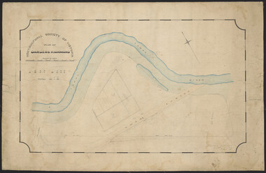
Map - FARADAY, 10/01/1879
Map: Parish of Faraday, County of Talbot. Parish plan. Earliest date on map December 1877.map, talbot, parish plan, faraday -
 City of Greater Bendigo - Civic Collection
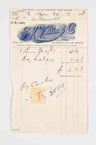
Financial record - Invoice, E.M Vains & Co
Ernest Morton Vains (1881 - 1951) was a local business man and Bendigo councillor who arrived in Bendigo in 1897 aged 16 from Kerang. In 1916 he founded the firm E M Vains and Co with his brother Sidney and they operated from Hargreaves Street in Bendigo with branches in Elmore, Mitiamo, Dingee, Knowsley, Heathcote and Prairie. E. M. Vains was a member of the City Council from 1922 - 1926 and was elected Mayor on August 29th, 1924. He played a prominent role in many of the City's community and industry groups and was a member of the Rotary Club which was founded in 1925 and a member of the Corona Lodge of Freemasons. Single page invoice from E.M. Vains and Co Auctioneers, Stock and Station Agents Bendigo. Letterhead features the unique R M Vains & Co logo with a bulls head, printed in royal blue ink.city of bendigo mayor, mayor vains, city of greater bendigo commerce, making a nation exhibition, mayoress vains, freemason -
 Bendigo Historical Society Inc.
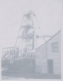
Negative - TOM PATULLO COLLECTION: MINING SITE
Negative print.Mining Site. Steel poppet legs, man on walk platform, wood stack,boiler house, large shed.cottage, miners, mining site., mining site. -
Bendigo Historical Society Inc.
Map - SANDHURST,. SHEET ?, 24/04/1907 ?
Map: Sandhurst (sheet No. missing). Parish planmap, bendigo, parish plan, sandhurst -
Port Melbourne Historical & Preservation Society
Plan - Stage & Foundations, Port Melbourne Town Hall, Port Melbourne City Council, 1916
Plan - details of stage and foundations for the 1915 Town Hall.port melbourne town hall, built environment - civic, city of port melbourne engineering dept -
Bendigo Historical Society Inc.
Plan - SANDHURST BOYS CENTRE COLLECTION: MASTER PLAN
Government of Victoria. Public Works Department. Master plan for the Loddon-Campaspe Regional Service Sandhurst Centre. [produced by] J Swan Chief architect, approved by B.W. Swan. Shows a brick Administration building, 6 [accommodation?] brick buildings (to be remodelled), the site for a new kitchen & amenities building, TDU no 1, BMU, TDU no 2 (new buildings), sites for maintenance workshops, vegetable garden. Also shows a residence, garage, recreation oval, with 3 existing weatherboard buildings, galvanised iron building, a weatherboard grandstand, a galvanised iron shed, fowl shed, 14 galvanised iron buildings [probably Nissan huts] and 2 toilet blocks. Location unknown 16.02.2023.bendigo, institutions, sandhurst boys centre, victoria public works dept; plans; sandhurst boys centre; j.swan -
 Eltham District Historical Society Inc
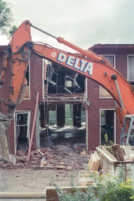
Negative - Photograph, Harry Gilham, Demolition of Eltham Shire Offices, 895 Main Road, Eltham, Aug. 1996
The Shire Offices opened in 1965 and were extended in 1971. The final Eltham Shire Council meeting was held in December 1994 before the forced amalgamations of municipal councils by the Kennett Government. The State-Government-appointed Commissioners (1994-1996) took the decision in July 1996 to demolish the Eltham Shire Offices. The demolition works started within 24 hours of the decision being made.Roll of 35mm colour negative film, 5 of 6 strips Associated printKodak Gold 100-5eltham shire office, demolition -
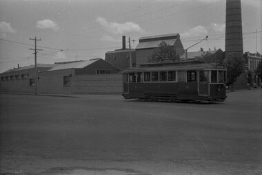
 Ballarat Tramway Museum
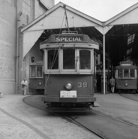
Negative - Set of 2, Geoff Grant, 2/04/1955 12:00:00 AM
Negative No. 265 and colour print made by colour laser printer (stored in folder ) of a head on shot of No. 39 in front of the Geelong depot, by Geoff Grant on 2/4/1955 while on an Australian Electric Traction Association tour. Other trams in view are 1 and 17. .1 - Copy large format print from Lloyd Rogers collection via Robert Green 2/2014. Added 4-4-2019 - 2 copies added. Original negative scanned at hi res 18/5/2020 and image updated.On small copy ex Robert Green in ink "Geelong car shed, 2-4-1955, ARHS Neg" On large print in pencil "Geelong 2-4-1955"trams, tramways, geelong, aeta, depot, tram 39 tram 1 tram 17 -
Bendigo Historical Society Inc.
Map - MARONG, 16/08/1881
Map: Parish of Marong, County of Bendigo. Parish plan (number 328 in map cupboard 1)map, bendigo, parish plan, marong -
Port Melbourne Historical & Preservation Society
Plan - Ada Mary A'Beckett Free Kindergarten, Fishermans Bend, Martin & Tribe, Architects, 21 Mar 1949
Martin & Tribe - ArchitectsPlans, Ada Mary A'Beckett Free Kindergarten - final details i.e. kerbing, tanbark, flagpole. 1947.education - kindergartens, garden city, built environment - civic, fishermans bend, ada mary a'beckett, martin & tribe, ada mary a'beckett kindergarten -
 Bendigo Historical Society Inc.
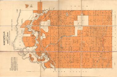
Map - JACK FLYNN COLLECTION: KANYAPELLA, 22/05/1939
Map: Parish of Kanyapella, Counties of Rodney and Moira. Parish plan.By Authority, T. Rider Acting Govt, Printer Melbourne. Drawn and Reproduced at the Dept. of Lands and Survey, Melbourne, Victoria.map, moira, parish plan, kanyapella, counties of rodney and moira -
 Melbourne Tram Museum
Negative, Wal Jack, 10/02/1941 12:00:00 AM
Black and white negative, by Wal Jack, of No.Y1 611 inbound in Swan St Richmond or Burnley after crossing the Yarra River bridge. Photo dated 10-2-1941 in the Wal Jack album along with details of the location.trams, tramways, swan st, y1 class, burnley, tram 611 -
Port Melbourne Historical & Preservation Society
Plan - Port Melbourne Town Hall, c. 1915
Plan of 'New Town Hall' i.e. 1915Tiny calculations in pencil, bottom centre and right; contract no. (no signatures)port melbourne town hall -
 Eltham District Historical Society Inc
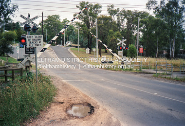
Negative - Photograph, Wattletree Road railway crossing, Eltham, February 1990
Roll of 35mm colour negative film, 4 stripsFuji 100main road, bridge, crossings, diamond creek, eltham, eltham north, wattletree road, railway crossing, railways, bridges -
 Eltham District Historical Society Inc
Negative - Photograph, J.A. McDonald, Healesville-Yarra Glen Road, c.May 1958
‘U’ slabs Paul Creek bridge, Tarrawarra Contractor WolfRecord of various Shire of Eltham infrastructure works undertaken during the period of 1952-1962 involving bridge and road reconstruction projects, sometimes with Eltham Shire Council Project Reference numbers quoted. It was during this period that a number of significant improvements were made to roads and new bridges constructed within the shire that remain in place as of present day (2022). In many situations, the photos provide a tangible visible record of infrastructure that existed throughout the early days of the Shire. The album was put together by or under the direction of the Shire Engineer, J.A. McDonald.infrastructure, shire of eltham, bridge construction, 1958-05, healesville-yarra glen road, paul creek bridge, w.e. wolf, tarrawarra -
University of Melbourne, Burnley Campus Archives
Plan, Grace Park Feature Plan, 1901-1983
(1) City of Hawthorn plan dated August 1983. Drawing No P12/24 Sheet 1 of 1. Surveyed: L.B. & H.K. Traced H.K. Scale 1:500. (2) Photocopy of map of area, Grace Park coloured in. 1901 handwritten on page.hawthorn, grace park -
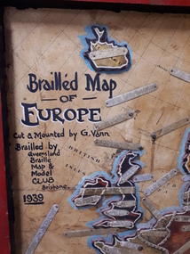 Vision Australia
Map - Object, Brailled Map of Europe, 1939
This tactile map of Europe was created in 1939, and brailled by the Queensland Braille Map and Model Club. Cut and mounted by G. Vann with geographical inforamtion provided by Miss E Southern. The Queensland Braille Map and Model Club was a volunteer organisation which produced tactile maps from the 1920s to the late 1940s. These were sent as presents to schools, organisations and missions for people who were blind or vision impaired around Australia, New Zealand, Syria, India, Canada, Papua New Guinea and Africa. Due to free postage of Braille obtained by Tilly Aston and her compatriots, the maps were transported gratis within Australia and at a cheap rate overseas. When this map was made, East Prussia, Danzig and the Levant States were all separate countries. Some information about each country (name, area in sq miles and population) is written on a small door on the right hand side, which can be opened to reveal the same information in Braille. At the base is a braille and handwritten note "Information about maps gratis from Miss E Southern "Kingsley" George St, Brisbane. "For lending to the Blind" is written at the base of the wooden frame.1 paper attached to wooden mount with metal labels, on the right hand side a small door with country information on the front and opens to reveal the same in Braille. queensland braille map and model club, r.f. tunley -
Glenelg Shire Council Cultural Collection
Education kit - Education Kit - Admella Teaching Resource Kit, Resource Kit, c. 2009
Green, 3 - ring binder containg Admella Teaching Resource kit including - Cd Disc of all files notes on the Admella story, activities for students reception - year 2, years 3-5, years 6 and 7 and years 8 and 9, plus dvd, 'Wreck of the Admella.' Front cover of binder has poster advertising wreck of Admella, 150th Anniversary in tones of blue, blue and white printing. -
Port Melbourne Historical & Preservation Society
Plan - Tramway, Normanby Road, Ingles Street to Boundary Street, Port Melbourne, 14 Mar 1893
Plan of tramway in Normanby Road from Ingles Street to Boundary Street, together with written specification for works attached (Reg 66.2), 1893.A.V. Heath (Town Surveyor) J.J. Bartlett (Mayor)engineering - roads streets lanes and footpaths, transport - tramways, town planning, town clerks, mayors, arthur victor heath, james john bartlett -
Port Melbourne Historical & Preservation Society
Plan, 1870s
Unidentified, undated plans believed to be for the Market shed, market site (ref Turnbull/U'ren pp 102-9, 132)engineering department - borough of sandridge, market reserve -
 Ballarat Tramway Museum
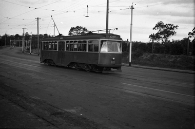
Negative, Wal Jack, late 1940's or early 1950's
Yields information about the tram services and the Ballarat A Power Station.Negative and Digital image of the Wal Jack Ballarat Negative file of No. 11 southbound in Ripon St passing Ballarat A power station.trams, tramways, ripon st, ballarat a power station, tram 27 -
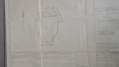 Peterborough History Group
Map - survey of Hamilton St wetland, Plan of Subdivision Hamilton Street
Subdivided to preserve the wetland, locals estimate it occurred between 1976 and 1983A3 plan of subdivision showing the outline of the swamp bounded by Hamilton St, Charles St and Cumming St. peterborough, survey map, golden pond -
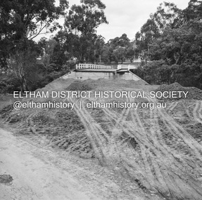 Eltham District Historical Society Inc
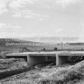
Negative - Photograph, J.A. McDonald, Eltham-Diamond Creek Road, 18 Sep 1959
Bridge construction Eltham-Diamond Creek road over the Diamond Creek (Wattletree Road), Eltham, September 1959 After some delay in receiving funds, work started on the bridge approaches in early September 1959. Traffic was still using the old bridge upstream. On Sunday, 20 September 1959, heavy flooding occurred in the stream and at 3:53 pm the old bridge was washed out. This photo was taken the Friday beforeRecord of various Shire of Eltham infrastructure works undertaken during the period of 1952-1962 involving bridge and road reconstruction projects, sometimes with Eltham Shire Council Project Reference numbers quoted. It was during this period that a number of significant improvements were made to roads and new bridges constructed within the shire that remain in place as of present day (2022). In many situations, the photos provide a tangible visible record of infrastructure that existed throughout the early days of the Shire. The album was put together by or under the direction of the Shire Engineer, J.A. McDonald.infrastructure, shire of eltham, bridge construction, 1959-09-18, bridge, diamond creek (creek), eltham, eltham north, glen park bridge, wattletree road bridge -
 University of Melbourne, Burnley Campus Archives
Plan - Plan and framed and glazed copy, Horticultural Society of Victoria Plan of Gardens, Richmond, 1865
Plan on linen paper of Burnley Gardens showing Yarra River, Swan St., railway, plan of west orchard and old garden sketched by hand in pencil. Inscription, "Presented to the Society," by A. Punch as C.E.Inscription, "Presented to the Society," by A. Punch as C.E. Oct 4th 1865"gardens, richmond, hoticultural society of victoria, a. punch -
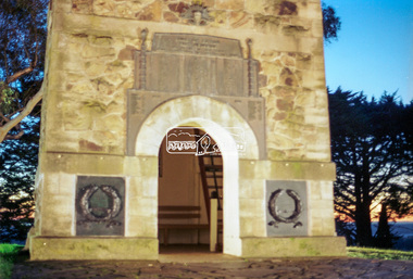 Eltham District Historical Society Inc
Negative - Photograph, Harry Gilham, Shire of Eltham War Memorial, Memorial Park, Kangaroo Ground, c.Apr 2002
Showing the new bronze plaques installed for the November 2001 re-dedication of the memorial as well as the floodlighting installed 1999.shire of eltham memorial park, driveway, kangaroo ground, floodlights, kangaroo ground tower, lighting, shire of eltham war memorial -
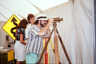 Eltham District Historical Society Inc
Negative - Photograph, Eltham Shire Council display, 1987 Eltham Community Festival, Alistair Knox Park, 7 Nov. 1987
Regular display by Council at the Eltham Festival providing ratepayers and visitors some insight into the daily operations of and services provided by Council and various equipment and machinery used.Roll of 35mm colour negative film, 4 stripsKodak GB 200 5096eltham festival, eltham shire council, infrastructure, shire of eltham, alistair knox park, displays, surveying equipment, theodolite -
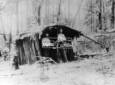 Eltham District Historical Society Inc
Negative - Photograph, Prospecting No. 1 Creek, Kinglake District
Two men stand in front of a forest hut. Photo appears on page 8 of book: "Kinglake: a collected history of the Kinglake district 1861 - 2011" with the caption: Harry Thomson and Maurice Power in their goldfield accommodation. They met at Caledonian goldfields and later both selected land at Kinglake.This photo forms part of a collection of photographs gathered by the Shire of Eltham for their centenary project book,"Pioneers and Painters: 100 years of the Shire of Eltham" by Alan Marshall (1971). The collection of over 500 images is held in partnership between Eltham District Historical Society and Yarra Plenty Regional Library (Eltham Library) and is now formally known as the 'The Shire of Eltham Pioneers Photograph Collection.' It is significant in being the first community sourced collection representing the places and people of the Shire's first one hundred years.Digital image 4 x 5 inch B&W Neg B&W Print 19 x 25 cmsepp, shire of eltham pioneers photograph collection, kinglake, gold miners, no. 1 creek, harry thomson, maurice power, hut, forest, propsecting -
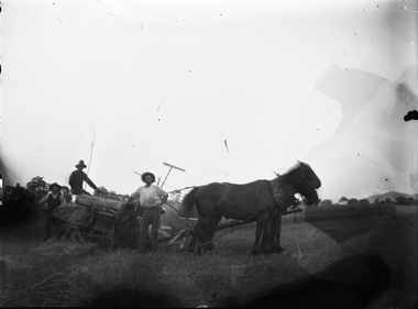 Wodonga & District Historical Society Inc
Negative - Haeusler Glass Negatives Collection - Men with horses in a paddock, c1910
The Wodonga Historical Society Haeusler Collection provides invaluable insight into life in late nineteenth and early twentieth century north east Victoria. The collection comprises manuscripts, personal artefacts used by the Haeusler family on their farm in Wodonga, and a set of glass negatives which offer a unique visual snapshot of the domestic and social lives of the Haeusler family and local Wodonga community. The Haeusler family migrated from Prussia (Germany) to South Australia in the 1840s and 1850s, before purchasing 100 acres of Crown Land made available under the Victorian Lands Act 1862 (also known as ‘Duffy’s Land Act’) in 1866 in what is now Wodonga West. The Haeusler family were one of several German families to migrate from South Australia to Wodonga in the 1860s. This digital image was produced from one of the glass negatives that form part of the collection, probably taken by Louis Haeusler (b.1887) with the photographic equipment in the Wodonga Historical Society Haeusler Collection.This item is unique and has well documented provenance and a known owner. It forms part of a significant and representative historical collection which reflects the local history of Wodonga. It contributes to our understanding of domestic and family life in early twentieth century Wodonga, as well as providing interpretative capacity for themes including local history and social history.Digital image created from the Haeusler Glass negative collection. 3 men with horses and farm machinery in a paddock.wodonga pioneers, haeusler family, glass negatives, dry plate photography, wodonga families, early farming -
Federation University Historical Collection
Plan, Michael Adermann
A number of photos of Michael Adermannmichael adermann