-
 Federation University Historical Collection
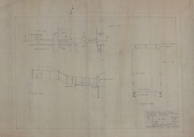
Plan, Ballarat School of Mines Preliminary Drawings for a Covered Way between Plumbing and Tippett Hall, 1962, 09/01/1962
Plan includes Ballarat School of Mines Administration Building and Tippett Hall (former Wesley Church)ballarat school of mines, architectural plan, plumbing, tippett hall, former wesley church, former ballarat school of mines museum -
 Eltham District Historical Society Inc
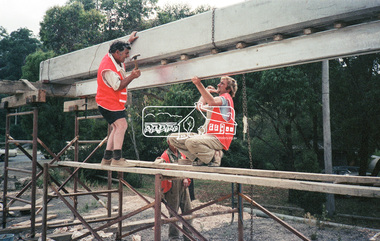
Negative - Photograph, Construction work, Main Street Bridge, Greensborough, c.Dec. 1983
The original bridge over the Plenty River was replaced by a single lane bridge each way fed by two lanes each way on either side. As traffic grew a second bridge was added to complete the divided road across the riverFilm - Kodak CM 400 5079 7 strips, 26 framesinfrastructure, roads, bridge construction, greensborough, main street bridge, road construction -
 Ringwood and District Historical Society
Legal record - Conditions of Sale (C.E.Carter), Mitcham- Crown Allotment 130, Heatherdale Estate - W Buxton to A Longland - 1923
Particulars and Conditions of Sale of Property , from Walter Buxton & Arthur Longland to Unstated Purchaser -
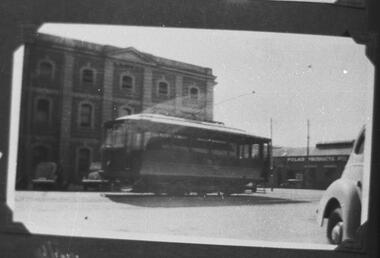 Ballarat Tramway Museum
Negative - Copy, Ray Pearson
Set of 19 copy negatives, of black and white photographs of Geelong trams from Ray Pearson Collection, taken by Dave Macartney in 1975c. Original negative held in the negative file. Scanned at 2400 dpi and cropped as necessary. Images as shown replaced by scan from the original Ray Pearson Album provided by Mal Rowe, April 2020 or that there is a better image. .1 - sprinkler/water tram - see Reg Item 5894 for a better version of this photograph. .2 - No. 11 summer car, side on view - image replaced. .3 - Postcard, No. 14 summer car, Moorabool St Geelong, Real Photo 1535 - image replaced. .4 - Postcard, No. 27, Valentine Series No. 1468, Ryrie St - image replaced .5 - Postcard No. 23, Valentine 1434, Moorabool St - image replaced .6 - Postcard, Rose Series P75, Moorabool St - image replaced .7 - No. 8 - image replaced .8 - old tram after sale .9 - No. 29 Birney - See also Reg Item 5852 for a better version of this photograph .10 - No. 14 - East - see also Reg Item 5847 for a better version of this photograph. .11 - No. 25 - Belmont - see also Reg Item 5870 for a better version of this photograph. .12 - sprinkler/water tram - image replaced .13 - No. 303, in Adelaide - before becoming Geelong 27, has destination of Rosewater - image replaced .14 - 9, 20 and 22 at depot - image replaced .15 - No. 3 - see also Reg item 5826 for a better version of this photograph. .16 - No. 26 - see also Reg Item 5872 for a better version of this photograph. .17 - No. 27 0 see also Reg Item 5851 for a better version of this photograph. .18 - Floral Tram - 1938 - image replaced .19 - No. 28 at Station, Newtown - image replaced trams, tramways, geelong, floral tram, birney -
Ringwood and District Historical Society
Legal record - Conditions of Sale (C.E.Carter), Scoresby, Lot (?) on Plan of Subdivision (?), Mr S.A.H.Mullins and (?), Circa 1930
Particulars and Conditions of Sale of Property , from Mr S.A.H.Mullins. -
Bendigo Historical Society Inc.
Plan - MARKS COLLECTION: LANSELL'S 180 PLAN, LEVELS 18, 19 AND 20
Plan of underground section of Lansell's 180 mine, levels 18, 19 and 20. On RH side of map Victoria Quartz Mining company claim marked, on LH side North Old Chum Co. 'West or hanging wall' marked above each level.bendigo, mining, lansell's little 180 mine -
 Eltham District Historical Society Inc
Negative - Photograph, Intersection of Mt Pleasant Road at Main Road, Eltham, c.Dec. 1983
Reconstruction work was planned for Main Road to install a roundabout at Mount Pleasant Road. Traffic to Lower Plenty and Templestowe to be diverted down Bridge Street (and Bolton Street) effective January 1984. The proposed roundabout did not proceed. Instead traffic islands on Mount Pleasant Road were installed in place of temporary blocked out islands and revised extended driveway to properties 622-642 Main Road with access off Mount Pleasant Road instead.Film - Kodak CM 400 5079 7 strips, 26 framesinfrastructure, roads, road construction, roundabout, road sign, main road, mount pleasant road, eltham -
Ringwood and District Historical Society
Legal record - Conditions of Sale (C.E.Carter), Ringwood - Crown Allotment 11. A.Wigley to E.R.Given. Dated January 1925
Particulars and Conditions of Sale of Property , Lot 57 Wantirna Road, Ringwood. From A.Wigley to E.R.Given. -
 Melbourne Tram Museum
Legal record, Melbourne & Metropolitan Tramways Board (MMTB), MMTB By-Laws, 1949 - 1951 & 1976
Printed documents - MMTB By-Laws. .1 - printed document - 16 pages - side stapled - 4 foolscap sheets folded and printed both sides - By Law No. 9 - detailing Tolls, Fares and Charges - dated 2-9-1949. .2 - as for .1, By Law No. 10 - dated 15/2/1950. .3 - printed document - 4 pages - 1 foolscap sheet folded printed both sides - By Law No. 11 - General - regarding passenger behaviour, conduct, eg offensive language, smoking, alcohol, spitting, payment of fares etc. - dated 14-6-1951. .4 - photocopied A4 sheet - By Law 11 - (General) Amendment No. 2 - dated 25-10-1976 - increasing the penalty to not exceeding $50.trams, tramways, mmtb, by laws, wattle park, fares, tickets, passengers, behaviour, smoking -
Bendigo Historical Society Inc.
Plan - HORWOOD COLLECTION: DRAWINGS FOR CONSTRUCTION OF 18'' ENGINE
Engineers plan for an 18 '' engine. Written on bottom 'J. Horwood and Sons, Engineers, Sandhurst. 18 IN Engine, Scale one inch = one foot' Plan drawn in fine black pen on waxed paper.bendigo, industry, horwood foundry, horwood, foundry, mining equipment -
Port Melbourne Historical & Preservation Society
Plan - Annotated and handcoloured by Peter LIBBIS to indicate his research into Libbis family residences and hotels on copy of a section of an MMBW map, Melbourne and Metropolitan Board of Works, c. 1980s
Peter LIBBIS obtained these copies from the MMBW when he researched his family history in the 1980s. He has annotated them, colour in hotels etc. Donated to Society in 1997.One of a group of 19 photocopies of various 20th century MMBW plans, annotated/coloured in to indicate residences of Libbis family and local hotels, by Peter LIBBIS in family and hotel research - Graham to Poolman, first bank houses 5.1.1930hotels, built environment, melbourne and metropolitan board of works, libbis family -
 Bendigo Military Museum
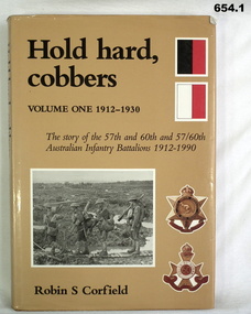
Literary work - BOOK, 1) Hold Hard, Cobbers Vol. 1 1912 - 1930 .2) Hold Hard, Cobbers Vol 2 1930 -1990, 1992
Two volumes detailing the story of the 57th, 60th and 57/60th Australian Infantry Battalions from 1912 to 1990. Donated by Frederick Ernest Addlem VX142253 57/60th Batt Refer Cat No 432.2 for his service history and 937P.Both volumes of Hold Hard, Cobbers. Both are hardcover with illustrations and illustrated dust jackets. .1 288 page, cut edged. Brown buckram and brown dust jacket. .2 352 page, cut edged. Green buckram with green dust jacket.Both items, on front end paper "Presented from the 57/60 Battalion (AIF) Association to the Bendigo RSL by Fred Addlem 1996"books, military, ww2 -
 Eltham District Historical Society Inc
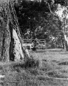
Negative - Photograph, State School No. 1362, Christmas Hills, c.1900
The School officially began in 1874 under head teacher Robert Harris, in rooms of the then Christmas Hills Post Office Store. By 1879, authorities agreed a new school was required. As with the citing of the Hall, there was considerable local controversy over whether the school should be built on the high point of School Lane, or the current location (then known as Scrubby Point). This pleasantly-sited bush school was opened in 1880, having been built by Jospeh Stevenson (Jr.) after his successful tender of £390. - Christmas Hills Past & Present (Yarra Glen & District Historical Society), 2004Early students / school early 20th century This photo forms part of a collection of photographs gathered by the Shire of Eltham for their centenary project book,"Pioneers and Painters: 100 years of the Shire of Eltham" by Alan Marshall (1971). The collection of over 500 images is held in partnership between Eltham District Historical Society and Yarra Plenty Regional Library (Eltham Library) and is now formally known as the 'The Shire of Eltham Pioneers Photograph Collection.' It is significant in being the first community sourced collection representing the places and people of the Shire's first one hundred years.Digital image 4 x 5 inch B&W Negsepp, shire of eltham pioneers photograph collection, christmas hills, school, state school no. 1362 -
Moorabbin Air Museum
Plan (item) - Bristol Aeroplane 170 schematic drawings, Assembly of Detachable Panel
Bristol Aeroplane Company Ltd -
 Kew Historical Society Inc
Plan - Subdivision Plan, Golf View Estate, c.1922
Pru Sanderson, in her groundbreaking ‘City of Kew Urban Conservation Study : Volume 2 - Development History’ (1988), summarised the periods of urban development and subdivisions of land in Kew. The periods that she identified included 1845-1880, 1880-1893, 1893-1921, 1921-1933, 1933-1943, and Post-War Development. These periods were selected as they represented periods of rapid growth or decline in urban development. An obvious starting point for Sanderson’s groupings involved population growth and the associated economic cycles. These cycles also highlighted urban expansion onto land that was predominantly rural, although in other cases it represented the decline and breakup of large estates. A number of the plans in the Kew Historical Society’s collection can also be found in other collections, such as those of the State Library of Victoria and the Boroondara Library Service. A number are however unique to the collection.The Kew Historical Society collection includes almost 100 subdivision plans pertaining to suburbs of the City of Melbourne. Most of these are of Kew, Kew East or Studley Park, although a smaller number are plans of Camberwell, Deepdene, Balwyn and Hawthorn. It is believed that the majority of the plans were gifted to the Society by persons connected with the real estate firm - J. R. Mathers and McMillan, 136 Cotham Road, Kew. The Plans in the collection are rarely in pristine form, being working plans on which the agent would write notes and record lots sold and the prices of these. The subdivision plans are historically significant examples of the growth of urban Melbourne from the beginning of the 20th Century up until the 1980s. A number of the plans are double-sided and often include a photograph on the reverse. A number of the latter are by noted photographers such as J.E. Barnes.The subdivision advertised as the Golf View Estate in Camberwell included 32 allotments bordering on Glen Iris Road, Smith Street (now Smith Road), St Andries Street and Camberwell Road. In the post-war period in which the subdivision took place, the significance of Camberwell as the ‘Heathiest of Suburbs’ because of the undulating nature of its terrain and its high altitude was promoted. The sales pitch aimed at attracting and selling to ‘Gentlemen’ who could take advantage of the nearby trams, which would take them to the ‘heart of the city’.subdivision plans - camberwell, golf view estate -
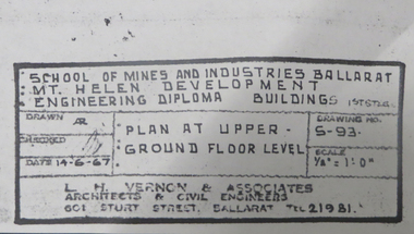 Federation University Historical Collection
Plan, Mt Helen Engineering Diploma Buildings, 1967, 14/06/1967
Copies of plans for Mount Helen E Building. mt helen campus, engineering building, mt helen e building, metallurgy, engineering, l.h. vernon and associates, architectural drawings -
Moorabbin Air Museum
Plan (item) - Bristol Aeroplane schematic drawings, Assembly of BoomSkin ....Rear Spar- Bottom.... title partly indecipherable
Bristol Aeroplane Company Ltd -
 Eltham District Historical Society Inc
Negative - Photograph, J.A. McDonald, Old house, Susan Street, Eltham, c. 1962
Williams house, Susan StreetRecord of various Shire of Eltham infrastructure works undertaken during the period of 1952-1962 involving bridge and road reconstruction projects, sometimes with Eltham Shire Council Project Reference numbers quoted. It was during this period that a number of significant improvements were made to roads and new bridges constructed within the shire that remain in place as of present day (2022). In many situations, the photos provide a tangible visible record of infrastructure that existed throughout the early days of the Shire. The album was put together by or under the direction of the Shire Engineer, J.A. McDonald.eltham, houses, susan street, williams house -
 Eltham District Historical Society Inc
Negative - Photograph, Eltham - Wingrove Park, early 1950s
Scar tree in foreground of Wingrove Park, named for Charles Symons Wingrove who was Secretary and Engineer for the Shire of Eltham for almost 50 years This photo forms part of a collection of photographs gathered by the Shire of Eltham for their centenary project book,"Pioneers and Painters: 100 years of the Shire of Eltham" by Alan Marshall (1971). The collection of over 500 images is held in partnership between Eltham District Historical Society and Yarra Plenty Regional Library (Eltham Library) and is now formally known as the 'The Shire of Eltham Pioneers Photograph Collection.' It is significant in being the first community sourced collection representing the places and people of the Shire's first one hundred years.Digital image 4 x 5 inch B&W Negsepp, shire of eltham pioneers photograph collection, eltham, george w bell, main road, wingrove park, tree, scar tree -
University of Melbourne, Burnley Campus Archives
Plan, Michael Green, Garden of D. Batten and J. Wundersitz Concept Plan Scale 1:50, c.2000
Tracing paper plan by Michael Green.michael green, gardens -
University of Melbourne, Burnley Campus Archives
Plan, Department of Agriculture - Victoria Burnley Gardens Hort. College Facilities, 1973-1983
Partly handdrawn plan of the horticultural facilities at Burnley Gardens.facilities, burnley gardens -
Moorabbin Air Museum
Plan (Item) - Miscellaneous Plans - Piper PA32 ; Piper Agricultural Plane ; UHF Communications Equipment, Untitiled Miscellaneous Plans - Piper PA32 ; Piper Agricultural Plane ; UHF Communications Equipment
Commonwealth Aircraft Corporation Library -
 Melbourne Tram Museum
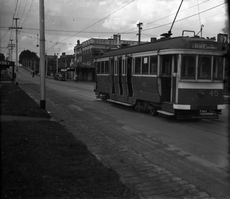
Negative, Wal Jack collection, c1944
Black and white negative, by Wal Jack?, of E 45 (St Kilda Beach, via Dandenong Road, Route 67) northbound in Hawthorn Road near intersection with Inkerman St. The building on the former remain in position. Advert for Turf Virginia Cigarettes. Photo not dated in the Wal Jack album. Possibly 14-9-42 based on other similar photos.trams, tramways, e class, hawthorn road, route 67, tram 45 -
University of Melbourne, Burnley Campus Archives
Plan, Detail of Sterilizing Trolley for New Plant Science Laboratory at Burnley Horticulture College, c. 1960
Plan by State of Victoria, Dept of Public Works. Drawn by R.M.department of public works -
Bendigo Historical Society Inc.
Plan - MARKS COLLECTION: PLAN GARDEN FRONT FORTUNA VILLA SANDHURST - G. LANSELL ESQ., JULY 3RD 1871
Plan for construction of Fortuna Villa, Sandhurst Title: Garden Front, Fortuna Villa, Sandhurst for G. Lansell Esq. Dated: 3rd July 1871 Coloured plan and elevation Condition: water damage and paper tears -
 Eltham District Historical Society Inc
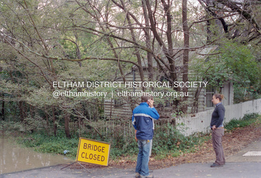
Negative - Photograph, Diamond Creek floodwaters near Jarrold Cottage opposite Dalton Street, Eltham, February 2005
Roll of 35mm colour negative film, 7 stripsKodak GC400-8diamond creek, eltham, floods, dalton street, jarrold cottage -
 Ballarat Tramway Museum
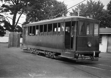
Negative, Wal Jack, late 1930's or early 1940's
Yields information about the scrubber tram.Negative and Digital image of the Wal Jack Ballarat Negative file of the Ballarat Scrubber on the depot fan - plain green, undated, possibly c1940. trams, tramways, depot, scrubber tram, tram scrubber -
Koorie Heritage Trust
Literary Work - Catalogue, Burrinja Fine Arts Pty. Ltd, Beginning : Burrinja, 1998
The Burrinja Gallery - named after Lin Onus features its first exhibition which includes some of his work and notes on him.n.p.; exhibition catalogue reporductions col.; notes; 25 cm.The Burrinja Gallery - named after Lin Onus features its first exhibition which includes some of his work and notes on him.burrinja gallery., omnus, lin-art work. -
 Kew Historical Society Inc
Plan - Subdivision Plan, High Street, Kew, 1920-1935
Pru Sanderson, in her groundbreaking ‘City of Kew Urban Conservation Study : Volume 2 - Development History’ (1988), summarised the periods of urban development and subdivisions of land in Kew. The periods that she identified included 1845-1880, 1880-1893, 1893-1921, 1921-1933, 1933-1943, and Post-War Development. These periods were selected as they represented periods of rapid growth or decline in urban development. An obvious starting point for Sanderson’s groupings involved population growth and the associated economic cycles. These cycles also highlighted urban expansion onto land that was predominantly rural, although in other cases it represented the decline and breakup of large estates. A number of the plans in the Kew Historical Society’s collection can also be found in other collections, such as those of the State Library of Victoria and the Boroondara Library Service. A number are however unique to the collection.The Kew Historical Society collection includes almost 100 subdivision plans pertaining to suburbs of the City of Melbourne. Most of these are of Kew, Kew East or Studley Park, although a smaller number are plans of Camberwell, Deepdene, Balwyn and Hawthorn. It is believed that the majority of the plans were gifted to the Society by persons connected with the real estate firm - J. R. Mathers and McMillan, 136 Cotham Road, Kew. The Plans in the collection are rarely in pristine form, being working plans on which the agent would write notes and record lots sold and the prices of these. The subdivision plans are historically significant examples of the growth of urban Melbourne from the beginning of the 20th Century up until the 1980s. A number of the plans are double-sided and often include a photograph on the reverse. A number of the latter are by noted photographers such as J.E. Barnes.A roughly drawn and faded actual or projected subdivision of a parcel of land bordering on High and Mary Streets. The plan shows five allotments facing High Street and at their rear, another allotment facing Mary Street. In 1906, when the Board of Works surveyors completed Detail Plan 1589, the allotment in Mary Street is shown to include a building. The section of land attached to this building is shown to be undeveloped, thus making a further subdivision possible.subdivision plans - kew, high street -- kew (vic.), mary street -- kew (vic.) -
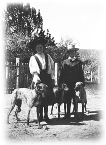 Wodonga & District Historical Society Inc
Negative - Haeusler Glass Negatives Collection - A girl and boy with three dogs, c1910
The Wodonga Historical Society Haeusler Collection provides invaluable insight into life in late nineteenth and early twentieth century north east Victoria. The collection comprises manuscripts, personal artefacts used by the Haeusler family on their farm in Wodonga, and a set of glass negatives which offer a unique visual snapshot of the domestic and social lives of the Haeusler family and local Wodonga community. The Haeusler family migrated from Prussia (Germany) to South Australia in the 1840s and 1850s, before purchasing 100 acres of Crown Land made available under the Victorian Lands Act 1862 (also known as ‘Duffy’s Land Act’) in 1866 in what is now Wodonga West. The Haeusler family were one of several German families to migrate from South Australia to Wodonga in the 1860s. This digital image was produced from one of the glass negatives that form part of the collection, probably taken by Louis Haeusler (b.1887) with the photographic equipment in the Wodonga Historical Society Haeusler Collection.This item is unique and has well documented provenance and a known owner. It forms part of a significant and representative historical collection which reflects the local history of Wodonga. It contributes to our understanding of domestic and family life in early twentieth century Wodonga, as well as providing interpretative capacity for themes including local history and social history.Digital image created from the Haeusler Glass negative collection. A girl and boy with 3 dogs. There is a wooden picket fence in the background.wodonga pioneers, haeusler family, glass negatives, dry plate photography, wodonga families