-
 Melbourne Tram Museum
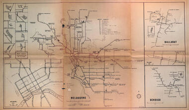
Map - Melbourne - Ballarat - Bendigo Tramways, 23-9-1969
Provides a detailed map of Melbourne, Ballarat and Bendigo tram lines - dated 23-9-1969. Shows street names, depot locations, depot layouts, track details including an insert for Sturt St Ballarat and destination locations. Provides a scale for each system. Not known who prepared the drawing.Yields information about the three operable Victorian systems at the date of preparation.Printed - dyeline? map on a folded sheet of papermap, melbourne, ballarat, bendigo, tramways, diagram -
 Federation University Historical Collection
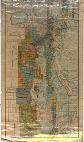
Map, Ballarat and Sebastapol Gold Mines, Late 19th Century
colored printed map on paper lined onto linen backingprinted "Rider & Mercer's Plan of the Ballarat & Sebastapol Gold Mines Scale 30 Chains to One Inch"gold mines, mine allotment map, mining leases, ballarat, sebastopol, rider and mercer, golden shaft co, prince of wales and bonshaw united, leviathan gold mines, holst and co, speedwell co, sebastopol plateau, rothschild co, tower hill co, south plateau, south star co, band of hop and albion consols, prince regent co, chenhall and co, despza, buninyong estate, one eye hully, winter's freehold, luplau plateau, e. morey, carrill's quartz -
 Ballarat Tramway Museum
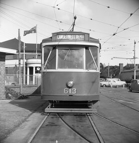
Negative, Geoff Grant, 7/05/1955 12:00:00 AM
Negative No. 286 and colour print made by colour laser printer (stored in folder ) of Y1 613 on the Camberwell Depot access track, 7/5/1955. Photo by Geoff Grant. Hi res scan of negative and image updated 19/5/2020.trams, tramways, melbourne, camberwell depot, depot, tram y 613 -
 Bendigo Historical Society Inc.
Map - TARNAGULLA SHEET 4, 25/11/1926
Map: Tarnagulla Sheet 4. Parish plan (number 306 in map cupboard 1)map, parish plan, tarnagulla -
 Eltham District Historical Society Inc
Negative - Photograph, J.A. McDonald, Eltham, Susan Street, Jan. 1961
January 1961 Looking south Brown excavating Brougham to Dalton (present-day Withers Way) F. Woods Consolidating showing soft fill over culvert after 9 months Just south of Brougham Street. To the immediate left is the present-day car park for the Elham Leisure Centre. The house on the left is immediately opposite Cromwell street and adjacent to the southwest corner of the Leisure Centre buiding (where the Williams house sits hidden from view)Record of various Shire of Eltham infrastructure works undertaken during the period of 1952-1962 involving bridge and road reconstruction projects, sometimes with Eltham Shire Council Project Reference numbers quoted. It was during this period that a number of significant improvements were made to roads and new bridges constructed within the shire that remain in place as of present day (2022). In many situations, the photos provide a tangible visible record of infrastructure that existed throughout the early days of the Shire. The album was put together by or under the direction of the Shire Engineer, J.A. McDonald.shire of eltham, infrastructure, 1961-01, cromwell street, eltham leisure centre, road construction, susan street -
 Eltham District Historical Society Inc
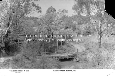
Negative - Photograph, The Rose Stereograph Company, Diamond Creek, Eltham, Vic, c.1919
Shows two bridge crossings over the Diamond Creek in Diamond Street, Eltham. The upper pedestrian crossing provided continual access for foot traffic during times of flood. The railway came to Eltham in 1901, the Eltham Railway Station is visible in the distance as well as a wooden bodied Tait (Red Rattler) First Class train carriage. The Tait train was first introduced in 1910 as a steam locomotive hauled carriage and in 1919 electric motor carriages were introduced however the line to Heidelberg was not electrified till 1921 and to Eltham in April 1923. The Railway General Store on Main Road is visible beyond the station and was built by Luther Haley in 1902. It was the first shop in the present day shopping centre. It was later known as lloyd's stopre (1917-1920) followed by a succession of six other owners until purchased by Eric Staff in 1939. This glass plate negative was used to manufacture postcards (1:1 printing) for commercial sale by the Rose Sterograph Company and its subsidiaries. George Rose founded the Rose Stereograph Company in 1880 and was joined by Herbert (Bert) Cutts in the early 20th Century. The pair formed a lifetime working partnership and strong personal friendship. Assisted by George’s two sons, Herbert George and Walter, and later by Neil Cutts, the Rose Stereograph Company continued its operations for more than 140 years. The company was initially built on stereographs, but as cinema took over and stereographs fell out of fashion, the Rose Stereograph Company developed Australia’s first commercially viable photographic postcard business. Specialising in postcards of iconic historical moments and significant landmarks, The Rose Stereograph Company became a staple of the Australian travel industry.This remarkable collection of glass plate negatives, transparencies, and postcards – arguably Australia’s most significant photography collection outside of public hands – has been passed down through the generations, surviving war, relocation, and the harsh Victorian climate. The historic Rose Stereograph collection is the culmination of George Rose’s dream of capturing and preserving precious moments in time and remains the legacy of the Rose and Cutts families. It is with great sadness that the Cutts family says goodbye to a collection that spans five generations and 140 years. The Cutts family understands that for these historically important pieces to rest with one family is to deny others the pleasure of their custodianship.Glass Plate Negative Size: 9 x 13.9 cmDiamond Creek, Eltham, Vic., The Rose Series P. 4314, Copyrighteltham, postcard, travel, rose stereograph company, glass plate negative, rose series postcard, tait train, eltham railway station, railway store, staffs general store, diamond creek, diamond street bridge, lloyd's general store, railway station, peter and elizabeth pidgeon collection -
Stawell Historical Society Inc
Map, Township of Moyston, Parish of Moyston, County of Borung, 1956
Township of Moyston, Parish of Moyston, County of Borungstawell -
University of Melbourne, Burnley Campus Archives
Map, Photo Mapping Services Pty. Ltd, Burnley College Burnley Gardens, 1995
Map compiled by Photo Mapping Services Pty. Ltd., using aerial photography, dated 9th July, 1995. (1) Coloured proof. Scale 1:500. (2) aerial views, with and without trees marked, of Burnley Gardens. (2) Map with trees on paper. (3) Map without trees on paper, sections numbered, no legend.burnley college, gardens -
 Ballarat Tramway Museum
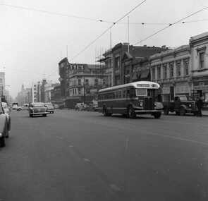
Negative, Geoff Grant, 16/06/1955 12:00:00 AM
Negative No. N304 and black and white print made by a laser printer (stored in folder ) of Bourke St Bus 538 travelling east along Bourke St. Spring St. on 16/6/1955. Photo by Geoff Grant. Has Florentino's, Burns Oates Booksellers, Tyes Buildings and Lawry's Tea Rooms, bread shop in background. Negative scanned hi res and imaged updated 20/5/2020.trams, tramways, melbourne, bourke st., buses, tram bus 538 -
Whitehorse Historical Society Inc.
Map, City of Nunawading, 1980?
Map of the City of Nunawading showing streets to south of Burwood Highway and east of Springvale Road.Map of the City of Nunawading showing streets to south of Burwood Highway and east of Springvale Road.Map of the City of Nunawading showing streets to south of Burwood Highway and east of Springvale Road.city of nunawading, historical -
Glenelg Shire Council Cultural Collection
Negative - Negative - Portland Public Baths, ZILLAH MASCHMEDT, PHOTOGRAPHER, c. 1934
NEGATIVE FOR BLACK AND WHITE PHOTOGRAPH. View from Portland Baths, looking back to Nun's Beach. Small bathing shed ? toilet blockportland public baths -
Bendigo Historical Society Inc.
Map - CAMPBELL COLLECTION: BENDIGO & DISTRICT MAPS
Map. Bendigo Whipstick, Scale 40 chains to 1 inch, Forests Commission Victoria, map N0.3, legend for roads and land and forest. (number 371 in map cupboard 1)map, bendigo, country lands -
Bendigo Historical Society Inc.
Map - HUNTLY : COUNTY OF BENDIGO, August 1954
Map. Huntly, County of Bendigo. Whirrakee, Bagshot, Wellsford, Nerring, Neilborough, Township of Huntly. Drawn and reproduced at the Department of Lands and Survey, Melbourne, Victoria. August 1954. Price 2/-. By authority W.M. Houston, Government Printer. (number 42 in map cupboard 1)W.M. Houston, Govt. Printer.map, bendigo, huntly -
Whitehorse Historical Society Inc.
Map, Archaeological Sites, 1984
Australian Mutual Provident Society Calendar 1984. Includes table of types of sites associated with aboriginals of Victoria.Australian Mutual Provident Society Calendar 1984. Includes table of types of sites associated with aboriginals of Victoria.Australian Mutual Provident Society Calendar 1984. Includes table of types of sites associated with aboriginals of Victoria.aborigines, australian mutual provident society, archaeology -
 Melbourne Tram Museum
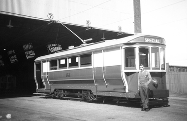
Negative, Wal Jack, 1940's
Black and white negative by Wal Jack of S 161 at the South Melbourne or Hanna St depot. Photo mid 1940's?trams, tramways, hanna st, south melbourne depot, s class, tram 161 -
 Eltham District Historical Society Inc
Negative - Photograph, Shire of Eltham, Eltham Shire Council Staff. Eltham Shire Office, 895 Main Road, Eltham, Jan. 1980
eltham, 895 main road, eltham shire council, eltham shire office, staff members -
Bendigo Historical Society Inc.
Map - CAMPBELL COLLECTION: BENDIGO & DISTRICT MAPS, 14-6-29
Map. Eppalock, Sedgwick and Strathfieldsaye. Scale 20 chains to 1 inch. Total area 3972 acres. Prepared in W.P.B. from Assessment Plan and Parish Plans. H.A. Darby. (number 378 in map cupboard 1)H.A.Darbymap, bendigo, agricultural lands -
Stawell Historical Society Inc
Map, Plan Shewing Position of Stawell, 1859
Plan Shewing Position of Stawellstawell -
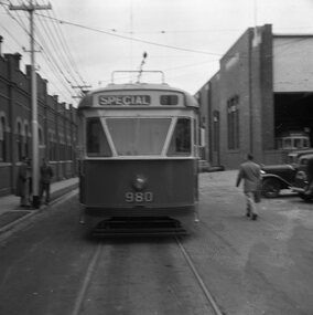 Ballarat Tramway Museum
Negative, Geoff Grant, 8/05/1954 12:00:00 AM
Negative No. 273 and colour print made by colour laser printer (stored in folder ) of Melbourne PCC tram 980, in Coldblo Road , Malvern depot, during an AETA tour on 8/5/1954. Photo by Geoff Grant. Envelope with negative describes the scene as "980 PCC type tram. It is unconventional tram with some American ideas and components." Hi res scan of negative and image updated 19/5/2020.trams, tramways, malvern depot, pcc, coldblo road, aeta, tram 980 -
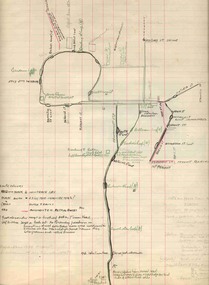 Ballarat Tramway Museum
Map, H.P. James, Ballarat tramway system, 1939
Hand drawn map contained within Reg. Item 2488, page 61 of the Ballarat Tramway system. Note does not show the Drummond St. North line. Shows the loops, horse tram loops, depots, ESCo bus routes, and notes on horse tram loops. Prepared by H.P. James Scan btm2515i2 and 2515i3 show the hand written notes in light pencil. Note Item Not formally Numbered.trams, tramways, map, depot, esco, horse trams, bus routes, ballarat -
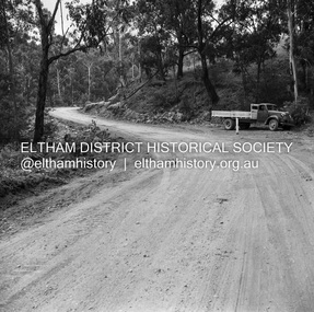 Eltham District Historical Society Inc
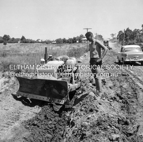
Negative - Photograph, J.A. McDonald, Heidelberg-Kinglake Road, Mar. 1960
Job 56M431 Curve improvement north of Yow Yow Creek March 1960 Contractor F.C. WoodRecord of various Shire of Eltham infrastructure works undertaken during the period of 1952-1962 involving bridge and road reconstruction projects, sometimes with Eltham Shire Council Project Reference numbers quoted. It was during this period that a number of significant improvements were made to roads and new bridges constructed within the shire that remain in place as of present day (2022). In many situations, the photos provide a tangible visible record of infrastructure that existed throughout the early days of the Shire. The album was put together by or under the direction of the Shire Engineer, J.A. McDonald.infrastructure, 1960-03, bridge construction, cherry tree road, heidelberg-kinglake road, road construction, shire of eltham -
Whitehorse Historical Society Inc.
Map, Yarra River, n.d
Copy of fold-out map 'Loddon 25' included in 'Lilydale', by Grace Aveling. Based on T.H. Nutt's original survey of the Yarra River, 1839.aveling, grace, nutt, t.h., yarra river -
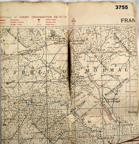 Bendigo Military Museum
Map - TRENCH MAP WW1, 1918
Area of map shows the River Sambre running from corner left to top corner right, Landrecies, Hachette, Petit Paris to Leval. Item re William Alexander No 502 AIF. refer cat No 3746.3 for his service details.Map, Enemy rear Organization France, Edition 3a, sheet 57A N.W, scale 1:20,000, Field Survey to 24.10.1918.Hand written on rear in black, “57A N.W”map, france, trench -
Bendigo Historical Society Inc.
Map - INFANCY OF BENDIGO, Original dated 28/10/1890
Map: Photocopy of the First sketch map of the Bendigo Diggings. Has been assembled from several photocopies taped together. Laid before the Frencham Committee by William Sandbach , a witness, 18 September 1890. There are Two of these maps. ( x ref 5673 , 8235 , Box 83 , 9077 )map, bendigo, city streets, infancy of bendigo, gold diggings, henry frencham, william sandbach, where was gold first found -
Stawell Historical Society Inc
Map, Department of Lands & Survey J. Noone, Township of Heatherlie. Parish of Baroka. County of Borung 1888, 1888
Stawell & Grampians Freestone Quarry Company Railway Reserve. Cross & masons Quarry Site. Mamnager'sHouse, Stead's boarding House Stawell and Grampians railwaySurveyed Township Showing Quarry and railway Reservephoto Lithographed at the Department of lands and Survey Melbourne By J Noone 15.6.88railway quarry -
Glenelg Shire Council Cultural Collection
Negative - Glass Plate Negative - Man with a bicycle near a bridge, c. 1890
Stereoscopic glass plate negative. Image shows a man with a bicycle standing at one end of wooden bridge. -
Bendigo Historical Society Inc.
Map - RUNNYMEDE : COUNTY OF BENDIGO, 8-12-13
Map. County of Bendigo, County of Rodney, Burnewang, Elmore, Nolan, Campaspe, Colbinabbin, Burramboot, Corop, Township of Runnymede, Campaspe River, Mount Pleasant Creek. Photo-Lithographed at the Department of Lands and Survey, Melbourne by W.J. Butson.8-12-13. Price 1/-. (number 107 in map cupboard 1)W.J. Butsonmap, bendigo, runnymede -
Bendigo Historical Society Inc.
Map - SUBDIVISION OF STERNBERG'S ESTATE, 24/06/1920
Map: Subdivision of Sternberg's Estate, Crown Allotments 75, 76, 76A, 76B and 77, Parish of Rochester West, County of Bendigo. Parish plan Canvas backed ( number 133 in Map Cupboard 1)map, bendigo, rural, sternberg's, crown allotments 75, 76, 76a, 76b, 77, rochester west, county of bendigo -
Glenelg Shire Council Cultural Collection
Negative - Glass Plate Negative - Stone house with people on the veranda, c. 1890
Glass plate negative. Images shows a stone house. Iron roof, verandah across front, roof striped. Iron lace work on verandah. Group of people (adults and children) on verandah. Garden in foreground. -
National Vietnam Veterans Museum (NVVM)
Literary Work, Poem written after the Battle of Long Tan ( no title shown)
It was 6 RAR's song, sung to the Green Berets by Barry Satlerbattle of long tan, 6 rar, vietnam war, 1961-1975 - poetry