-
 Northern District School of Nursing. Managed by Bendigo Historical Society Inc.
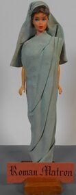
Education kit - Fabiola Roman Matron - Miniature Doll Collection - Nursing through the Ages
Fabiola - Roman Matron - Romans developed an organized medical system and study of hygiene. Roman women pre Christianity were independent owned property and wealth. Fabiola daughter of a great roman family converted to Christianity and became devoted to charitable work among the sick and the poor. Miniature 30cm doll dressed in long light blue sarong type dress with matching blue headwareName tag - Roman Matronnursing history, nursing uniforms, northern district school of nursing, miniature dolls -
 Eltham District Historical Society Inc
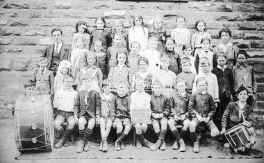
Negative - Photograph, W. Edmends, 3rd and 4th Grade, Eltham State School No. 209, 1919
Roll of 35mm colour negative film, 3 strips Associated print from negative (Copy of original print)Fuji 100eltham primary school, state school no. 209, eltham state school -
 Port Melbourne Historical & Preservation Society
Plan - Landscaping Westport Reserve, Port Melbourne, Graeme Bentley, Apr 1990
Plans for landscaping to complement Sandridge Life Saving ClubWorking drawings for landscaping Westport Reserve, Port Melbourne, 5pp, 1990'received 07 Jun 1991'natural environment - beaches and foreshore, westport reserve, bentley, graeme -
 Wodonga & District Historical Society Inc
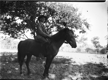
Negative - Haeusler Glass Negatives Collection - A man on horseback, c1910
The Wodonga Historical Society Haeusler Collection provides invaluable insight into life in late nineteenth and early twentieth century north east Victoria. The collection comprises manuscripts, personal artefacts used by the Haeusler family on their farm in Wodonga, and a set of glass negatives which offer a unique visual snapshot of the domestic and social lives of the Haeusler family and local Wodonga community. The Haeusler family migrated from Prussia (Germany) to South Australia in the 1840s and 1850s, before purchasing 100 acres of Crown Land made available under the Victorian Lands Act 1862 (also known as ‘Duffy’s Land Act’) in 1866 in what is now Wodonga West. The Haeusler family were one of several German families to migrate from South Australia to Wodonga in the 1860s. This digital image was produced from one of the glass negatives that form part of the collection, probably taken by Louis Haeusler (b.1887) with the photographic equipment in the Wodonga Historical Society Haeusler Collection.This item is unique and has well documented provenance and a known owner. It forms part of a significant and representative historical collection which reflects the local history of Wodonga. It contributes to our understanding of domestic and family life in early twentieth century Wodonga, as well as providing interpretative capacity for themes including local history and social history.Digital image created from the Haeusler Glass negative collection. An unidentified man on horseback. There is a small dog standing beside them.wodonga pioneers, haeusler family, glass negatives, dry plate photography, wodonga families -
Bendigo Historical Society Inc.
Map - BENDIGO SHEET 2, No date visible
Map: Parish plan showing portion of Bendigo city, West from the Echuca rail line, showing lake weeroona ( number 136 in Map Cupboard 1)map, bendigo, city streets, bendigo sheet 2, bendigo streets -
Moorabbin Air Museum
Negative (Item) - Bristol Aircraft Company Drawings
-
 Melbourne Tram Museum
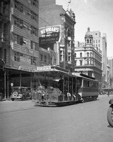
Negative, Ellis Collection, Summer 1935
Negative (approx. 75 x 132) of a cable tram set, bogie trailer in Elizabeth St Melbourne between Collins and Little Collins St with the destination of Brunswick. In the background is the Beehive building (opened in 1935 advice of Rod Atkins 19-6-2019 by e-mail). The cable tram in Elizabeth St closed on 28/9/1935. Photo taken early 1935 on a summers day. The building also in the view, Newman's has a sign saying they have moved. Hi Res image filed in the dbtext/hawthtramcoll/Large Images/htd3622Large.jpgEnvelope containing typed "Cable Tram City / Clear Normal Speed:"trams, tramways, cable trams, elizabeth st -
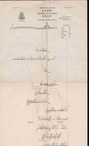
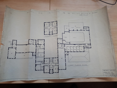 Vision Australia
Plan - Image, Royal Vic Institute for the Blind Hirings Service, 18/12/1943
Plan of the first and second floors of the main building at 557 St Kilda Road, created by the RAAF during it's occupation of the same between 1942-1944.1 architectural plan of St Kilda Road main buildingroyal victorian institute for the blind, plans, raaf -
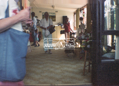 Eltham District Historical Society Inc
Negative - Photograph, Open Day, Eltham Living and Learning Centre, 7 Nov 1987
Open Day, Eltham Living and Learning Centre, part of the Eltham Community Festival activites, 7 Nov. 1987eltham, eltham festival, eltham living and learning centre, living and learning centre, open day -
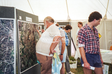 Eltham District Historical Society Inc
Negative - Photograph, Eltham Shire Council display, 1987 Eltham Community Festival, Alistair Knox Park, 7 Nov. 1987
Regular display by Council at the Eltham Festival providing ratepayers and visitors some insight into the daily operations of and services provided by Council and various equipment and machinery used.Roll of 35mm colour negative film, 4 stripsKodak GB 200 5096aerial photographs, alistair knox park, displays, eltham festival, eltham shire council, infrastructure, shire of eltham, eltham south -
Bendigo Historical Society Inc.
Map - LYELL : COUNTY OF BENDIGO, 24-9-07
Map. Lyell, County of Bendigo, Sedgwick, Sutton Grange, Hawkestone, Kimbolton, Eppalock, Myrtle Creek, Coliban River. Photo-Lithographed at the Department of Lands and Survey, Melbourne by T.F. McGauran, 24-9-07, Price 1/-. (number 70 in map cupboard 1)T.F. McGauranmap, bendigo, lyell -
Stawell Historical Society Inc
Map, Department of Crown Lands and Survey Victoria, Allotments in the Township of Banyana. Parish of Burrum Burrum. 1946 / 1971, 1971
Richardson River. Avon River JunctionPaper Map of County of BorungReprint of the 1946 edition. Drawn and reproduced at the Department of Crown Lands and Survey Victoria 1971.survey -
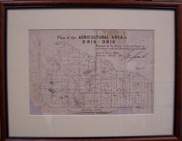 Glenelg Shire Council Cultural Collection
Map - Map of Drik-Drik, 1865
Displayed at History House.Print of map pasted onto board, mounted and framed under glass. Buff-coloured mount. Mahogany stained moulded wood frame, black inner frame.Front: Plan of the Agricultural Area of Drik-Drik L.2556/Prepared by the Board of Lands and Works in accordance with the "Amending Land Act 1865". Lands and Survey Office, Melbourne 11th May 1865. (printed, upper centre). Back: Duncan Hedditchmap, drik drik, plan, geography, cartography -
Glenelg Shire Council Cultural Collection
Negative - Negative - Sapling Creek, Glenelg River, Nelson, Victoria, c. 1936
Transparency for black and white photo. 'Sapling Creek' 26 miles upstream from mouth of Glenelg River at Nelson, Vic -
Bendigo Historical Society Inc.
Map - PANNOOMILLOO : COUNTY OF BENDIGO, 1957
Map. Pannoomilloo, County of Bendigo, Pannoobamawm, Milloo, Warragamba, Diggorra, Property Allotments. Drawn and Reproduced at the Department of Lands and Survey,1957. Price 2/-. (number 412 in Map Cupboard 1 ).W.M. Houston, Government Printer, Melbourne.bendigo, hospital -
Port Melbourne Historical & Preservation Society
Education kit - Student Chalkboard, 1970's - 1992
Invented in the 1840's, chalkboards were commonly use for children in primary school education until the 21st century. Oblong green chalkboard on Masonite backing.education - primary schools, state school 1427 nott street -
Bendigo Historical Society Inc.
Map - EPPALOCK : COUNTY OF BENDIGO, 1982
Map. Eppalock, County of Bendigo, Axedale, Knowsley, Heathcote, Tooborac, Kyneton, Lancefield, Pyalong, Seymour, Graytown, Toolleen, Colbinabbin, Costerfield, Redesdale, Mia Mia, Nagambie, Department of Interior, Puckapunyal Military Area, Various connecting roads. Shire of McIvor. Updated Dec.1982. (number 40 in map cupboard 1)map, bendigo, eppalock -
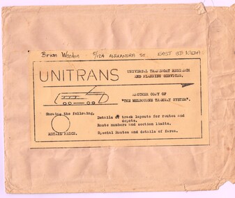 Melbourne Tram Museum
Map, Russell J. Nowell, "The Melbourne Tramway System", mid 1960's
Printed map (dye line process) on a large sheet of paper contained within an envelope. .1 - Brown paper envelope with a printed sheet glued to the envelope - giving title "The Melbourne Tramway System", publisher ("Unitrans - Universal Transport Research and Planning Services" - with a space for the retail price. .2 - Map printed on paper and folded into 16 parts - details the track layouts for routes and depot, route numbers, sections, Latrobe and William St services and details of fares. Has a sketch of tram 980 in the top right hand corner along with details of the tram system. Also includes depot locations, reserved tracks and derails at level crossings, though railway level crossings are not shown. Produced by Russell J. Nowell - gives address and phone number along with the "UniTrans" logo. Advised by other members, he was a Tasmanian. Not dated, but appears to be mid 1960's. Plan scanned 1-3-2016 as a tiff file.Envelope has the name and address of the donor "Brian Weedon 5/124 Alexandra St East St Kilda"trams, tramways, map, mmtb, depots, tram routes, trackwork -
 Ballarat Tramway Museum
Map, H.P. James, Ballarat tramway system, 1939
Hand drawn map contained within Reg. Item 2488, page 61 of the Ballarat Tramway system. Note does not show the Drummond St. North line. Shows the loops, horse tram loops, depots, ESCo bus routes, and notes on horse tram loops. Prepared by H.P. James Scan btm2515i2 and 2515i3 show the hand written notes in light pencil. Note Item Not formally Numbered.trams, tramways, map, depot, esco, horse trams, bus routes, ballarat -
Whitehorse Historical Society Inc.
Map, Tunstall 1945, 1945
A map drawn from memory about 20 years ago by Colin Fraser of the businesses and residents of Tunstall, 1945, including the location of Fraser General Store.A map drawn from memory about 20 years ago by Colin Fraser of the businesses and residents of Tunstall, 1945, including the location of Fraser General Store.A map drawn from memory about 20 years ago by Colin Fraser of the businesses and residents of Tunstall, 1945, including the location of Fraser General Store.tunstall, tunstall railway station, tunstall avenue nunawading, tunstall state school no 4190, fraser, colin -
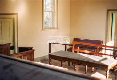 Eltham District Historical Society Inc
Negative - Photograph, Harry Gilham, Interior, Eltham Courthouse, 730 Main Road, Eltham, Sep 2004
eltham courthouse -
Stawell Historical Society Inc
Map, The Township of Elmhurst, Parish of Glenpatrick, Wimmera District
The Township of Elmhurst, Parish of Glenpatrick, Wimmera Districtstawell -
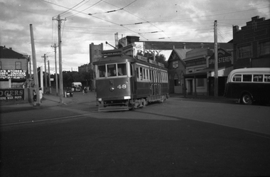 Melbourne Tram Museum
Negative, Wal Jack, c1946
Black and white negative, of Victorian Railways trams 48 turnout out of Bay Road Sandringham, after passing the junction to the Sandringham Tram depot. Note the white bumper bars. Photo c1946. (Possibly 12-3-1946 - see Reg Item 5773) In the background is the Roxy Theatre and the spire of the All Souls Anglican Church. (The church spire has since been rebuilt).Also in the background is the Salvation Army Hall, Barker Upholster and two buses. Photo not in the Wal Jack Victorian Railways Album.trams, tramways, victorian railways, vr trams, bay road, sandringham, buses, tram 48 -
 Bendigo Historical Society Inc.
Map - SNOB'S HILL - PLAN OF SNOB'S HILL MINES
a. . Handdrawn copy of Snob's Hill Mines by Caleb Thomas (Long Section) 1885. Top drawing show mines and the distance between them. Lower drawing shows leases at a scale of 8 chains to 1 inch. Dams and sand heaps are included. The second page shows x-sections of the poppet legs and their heights. Shaft numbers are included. Two of the pulley diameters are also shown. b. Document headed Caleb Thomas cross sections 10.10.1884. South Catherine, engine east of shaft legs 44 ft high Ellenborough engine east of shaft, legs 40 feet Belmont and Saxby, engine and wheel west of shaft, legs 27 feet York and Durham, engine and wheel west of shaft legs 27 feet Snobs Hill , Old Williams, engine east of shaft legs 53 feet, L. Brace 21ft. 1884 Acadia Catherine engine west. Legs 44 feet, L.brace 11 ft.map, bendigo, goldfields, snob's hill, plan of snob's hill mines, caleb thomas, c reef united, catherine reef shaft, william's main, acadia, william's old main, gt northern, york & durham, snob's hill, belmont & saxby, ellenborough, st mungo, golden pyke, united c'holders, compy, snowdon & co, sth catherine coy, princess alice, saunders, williams & coy, acadia co, wearon & co, snob's hill, nelson trib, kneebone tribute, la belle co, york & durham, north st mungo, saxby & devonshire trib, n? trib, belmont co, durham c'land, kitti trib, sadowa trib, ran?eu co, nth devonshire co, lady barkly, devonshire reef trib, central devonshire co, j c macartney, catherine united -
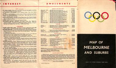 Melbourne Tram Museum
Map, Victorian Government Tourist Bureau, "Map of Melbourne and Suburbs", Jul. 1956
Map - .folded 12 sections full colour titled "Map of Melbourne and Suburbs". Issued at the time of the Melbourne Olympics by the Victorian Government Tourist Bureau. Has an index of Melbourne's suburbs, transport links, Places of Interest, Amusements, Facts of interest about Victoria. Major map shows the rail and tram lines, the detailed map of the CBD shows the buildings or locations referenced in the Tourist Guide to the City. Printed by the Victorian Railways - 2133-56trams, tramways, map, olympics, public transport, melbourne -
Moorabbin Air Museum
Plan (item) - Pressure Head System, Assembly of Sumps At Rear Spar & False Spar
The Bristol Airplane Company -
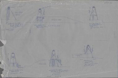
Bendigo Historical Society Inc.
Map - GREAT EXTENDED HUSTLER'S MINE - TRANSVERSE SECTION OF THE GREAT EXTENDED HUSTLER'S MINE
Transverse Section of the Great Extended Hustler's Mine on the Hustler's Line of Reef. Bulletin No 33, Plate No XII. Shows Poppet legs at the surface and Sill of Shaft at 788.99 feet above Sea Level, Cross Cuts and their depths, stone and geographical features encountered and their references and a number of enlarged drawing of sections of the cross cuts, Geological Survey of Victoria emblem and signed by H A Whitelaw, Underground Survey Office Bendigo, September 1913. The depths of crosscuts to No 21 were taken from plans of surveys by Mr Walker and Mr Craven, noted under Reference. Another note: This Saddle Reef is sketched from Mr Walker's plan. Dividends amounting to 360,000 pounds were obtained from it. This item has not been scanned or photographed.mining, parish map, great extended hustler's mine, transverse section of the great extended hustler's mine, old shaft, mr walker, mr craven, geological survey of victoria, underground survey office bendigo, h a whitelaw -
Moorabbin Air Museum
Plan (item) - Bristol Aeroplane 170 schematic drawings, Installation of Bolts -Rear Spar Top Boom
Bristol Aircraft Company Ltd -
 Bendigo Historical Society Inc.
Map - STRUGNELL COLLECTION: HUSTLER'S LINE OF REEFS K.K.MINE, September 1913
Map, Hustler's Line of Reefs, K.K.Mine,Transverse section.Plate No.XXX11(32).Geological Survey of Victoria.Bulletin 33.Signed H.A.Whitelaw. Drawing shows the vertical shaft descending to over 1932 feet and appears to show samples of connecting horizontal shafts with their respective mineral contents and dotted lines appear to show connecting reefs .Underground Survey Office, Bendigo,map, bendigo, k.k.mine -
Moorabbin Air Museum
Plan (item) - Simulator Assembly Tow Boom United Technologies Sikorsky Aircraft
Drawing Number :65725-76574 Rev.1