-
 Northern District School of Nursing. Managed by Bendigo Historical Society Inc.
Education kit - Army Nurse 1910 Miniature Doll - Nursing through the Ages
30cm Miniature Doll dressed in long blue dress with long white apron. Red cape and white veil on head. White cuffs on sleevesName Tagminiature doll, nursing uniform, nursing history -
 Glen Eira Historical Society
Plan - Centre Road, 734, Bentleigh East
A one page typed letter, dated 30/09/1970 addressed to S P Simmonds Estate Agency from William Lasica and Co Solicitors requesting a valuation of the property at 734 Centre Road, Bentleigh East. The file also includes four pages of handwritten, undated and unattributed working notes with property description, calculations and a rough plan (96mm x 94mm) of the ground floor of the building for the valuation. Also included in the file is a two page duplicate copy of a typed letter, dated 08/10/1970 from W V Scott to William and Lasica Co Solicitors containing the valuation of the relevant property and rental details. The file also includes a one page photocopy of a handwritten document dated 15/11/1967. It gives details of a previous mortgage. The file also includes a photocopy, dated 26/09/1970, of the Certificate of Title of Lot 6 of Subdivision No 60044 Parish of Moorabbin. It includes a plan of the property (139mm x 123mm).klauss anna sara, klauss edward, green william james, green margaret estelle, green william thomas, myers thomas lee, lombard joseph patrick, graham george kinnell, tobin thomas norman, mcintosh edward joseph, bentleigh east, east bentleigh, centre road, bentleigh station, omeo court, east boundary road, s p l constructions pty ltd, r k c nominees pty ltd, maryland street caulfield investors, flats, land values, land titles, rents, renting, \ -
Moorabbin Air Museum
Plan (item) - C.A.C Wirraway Agricultural Conversion XP.77
-
Port Melbourne Historical & Preservation Society
Plan - Alternative proposed renovation to shop fronts, Bay Street, Port Melbourne, Wunderlich Ltd, c. 1916
Alternative design for market shop front for no. 219 Bay Street for Port Melbourne Council c1916Drawing endorsed by R.N. Solly representative of Wunderlich Ltd in top right hand corner:No. 695 in bottom left hand cornerbuilt environment - commercial, market reserve, wunderlich ltd, bay street -
Glenelg Shire Council Cultural Collection
Plan - Ship Plan / Mould, n.d
Wooden pattern for mould for boat fitting. Arch shaped, flat base. Smaller arch shaped piece attached to front and back. Centre section shaped narrower at top, small wooden cylinder through centre. Traces of white paint. -
 Warrnambool and District Historical Society Inc.
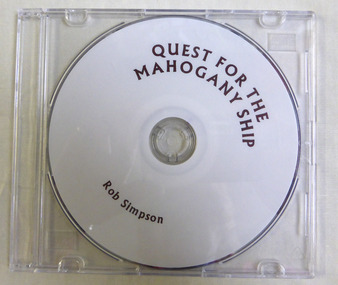
Education kit - CD, Quest for the Mahogany Ship, 2014
This CD relates the story of the quest to discover the Mahogany ship wreck which purportedly lies to the west of Warrnambool and is believed to be either a Spanish or Portuguese ship. It is named the mahogany ship due to the dark colour of the wood seen by early settlers.The story of the Mahogany ship is an integral part of Warrnambool's maritime historyThis a DVD with a plain white face with brown printing on it. ‘Quest For the Mahogany Ship, Rob Simpson’mahogany ship, warrnambool history, warrnambool shipwrecks -
 Federation University Historical Collection
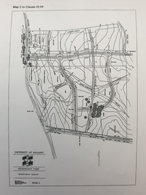
Plan, Ballarat Technology Park plans, c1998
.1) Alotment plan .2) contour planballarat technology park, mount helen campus, canadian wetlands, ballarat to buninyong railway line, sub-division layout -
 Ringwood and District Historical Society
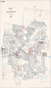
Map, City of Ringwood - Rateable Properties Layout - c.1966
A0-size (approx) map of named streets, lot-numbered properties and locality features within City of Ringwood boundary. Coloured outlines of subsequent subdivisions. Seperate enlargement showing northern half of map.Scale: 8 chains to 1 inch. -
 Wonga Park Community Cottage History Group
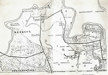
Plan (sub-item) - Black and White, Map of “Yarra Brae”, site of Scout Jamboree and World Rover Moot, Not known, possibly 1985
-
 Peterborough History Group
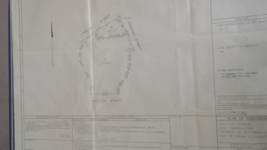
Map - survey of Hamilton St wetland, Plan of Subdivision Hamilton Street
Subdivided to preserve the wetland, locals estimate it occurred between 1976 and 1983A3 plan of subdivision showing the outline of the swamp bounded by Hamilton St, Charles St and Cumming St. peterborough, survey map, golden pond -
Whitehorse Historical Society Inc.
Plan - Family Tree, McGhee and Eriksson Families, 7/07/1993 12:00:00 AM
Information on the family history of the McGhee and Eriksson families.Information on the family history of the McGhee and Eriksson families as supplied by Margaret Sells.Information on the family history of the McGhee and Eriksson families. genealogy, mcghee family, eriksson family -
Glen Eira Historical Society
Plan - Bambra Road, 271, Caulfield South
A hand-drawn plan (203mm x 297mm), most likely of 271 Bambra Road, Caulfield South. Also included are handwritten notes, likely dated 6/08/1953, calculating increase of rent and listing tenant as Mrs Griffiths (Legacy Widow).griffiths mrs, bambra road, caulfield south, rents, legacy, widows, houses -
University of Melbourne, Burnley Campus Archives
Plan, Burnley Gardens. City of Richmond. Parish of Jika Jika - County of Bourke, 1927
Plan showing Burnley Gardens - bounded by Swan St to N, Yarra River to E, Richmond Park on S and W side. Photo-lithographed at Dept. of Lands & Survey by W.J. Butson. Plan shows old orchard, fowl sheds, coops and yards, milking shed, silo, nursery, glasshouse, fattening pens, dairy, garden, orchards area in S.W. area.burnley gardens, orchards, sheds, nursery -
 Federation University Historical Collection
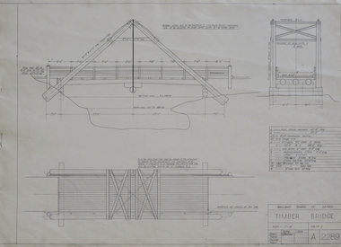
Plan, Plan for a Timber Bridge
Plan for a timber bridgetimber bridge, j. calisto, geoff biddington -
Whitehorse Historical Society Inc.
Map, Aerial photograph, c1950
Arial photo of Vermont South and Burwood East, Middleborough Road, Burwood Highway, Springvale Road, Highbury Road and environs.Aerial photo of Vermont South and Burwood East, Middleborough Road, Burwood Highway, Springvale Road, Highbury Road and environs.Arial photo of Vermont South and Burwood East, Middleborough Road, Burwood Highway, Springvale Road, Highbury Road and environs.vermont south, burwood east, aerial photographs -
Whitehorse Historical Society Inc.
Map, Nunawading Planning Scheme, 7/06/1994 12:00:00 AM
Local Section maps 1 - 4 with index. Geographical information system land Information Branch. Scale 1:10,000 Shows zoning under planning scheme.Local Section maps 1 - 4 with index. Geographical information system land Information Branch. Scale 1:10,000 Shows zoning under planning scheme.Local Section maps 1 - 4 with index. Geographical information system land Information Branch. Scale 1:10,000 Shows zoning under planning scheme.blackburn, blackburn north, blackburn south, forest hill, heatherdale, maps, nunawading, vermont, vermont south, town planning, burwood east, laburnum -
Glenelg Shire Council Cultural Collection
Plan - Plan - Port of Portland Authority slipway, 29/10/2010
Front: '19' - black texta, top right cornerport of portland -
Moorabbin Air Museum
Plan - Transmitters Training Notes, Department of Civil Aviation
-
 Melbourne Tram Museum
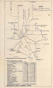
Map, Melbourne cable tram system, 1971?
Map showing the Melbourne cable tram system, with a list of opening and closing dates for the various lines, opened by the Melbourne Tramways Trust. Shows engine houses and car houses (or depots), location names, railways, and a scale. Includes notes on other dates tracks were changed and the Northcote to Clifton Hill line. No marks as to who prepared the map.Yields information about the Melbourne Cable Tram system.Foolscap sheet - Map - Melbourne cable tram system showing tracks, car houses and engine houses.Has a date stamp 22 Apr 1971 in bottom right hand corner.tramways, cable trams, trams, map, melbourne tramways trust, mtt, engine houses, depots, car houses -
 Vision Australia
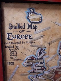
Map - Object, Brailled Map of Europe, 1939
This tactile map of Europe was created in 1939, and brailled by the Queensland Braille Map and Model Club. Cut and mounted by G. Vann with geographical inforamtion provided by Miss E Southern. The Queensland Braille Map and Model Club was a volunteer organisation which produced tactile maps from the 1920s to the late 1940s. These were sent as presents to schools, organisations and missions for people who were blind or vision impaired around Australia, New Zealand, Syria, India, Canada, Papua New Guinea and Africa. Due to free postage of Braille obtained by Tilly Aston and her compatriots, the maps were transported gratis within Australia and at a cheap rate overseas. When this map was made, East Prussia, Danzig and the Levant States were all separate countries. Some information about each country (name, area in sq miles and population) is written on a small door on the right hand side, which can be opened to reveal the same information in Braille. At the base is a braille and handwritten note "Information about maps gratis from Miss E Southern "Kingsley" George St, Brisbane. "For lending to the Blind" is written at the base of the wooden frame.1 paper attached to wooden mount with metal labels, on the right hand side a small door with country information on the front and opens to reveal the same in Braille. queensland braille map and model club, r.f. tunley -
Glenelg Shire Council Cultural Collection
Plan - Plans / Line Drawings - Port of Portland Authority Slipway Fishing Vessel Soluna, Victoria, 06/10/1989
Port of Portland AuthorityFront: '33'- black texta, top right corner. 'JOB NO 3110' - black pen -
University of Melbourne, Burnley Campus Archives
Plan - Photocopy, Burnley Gardens New Plant Research Laboratory, 1960
Sheet 1 of 8Photocopy, reduced in size, of original plan. Signed by Chief Architect, Dept of Public Works, Victoria. Site plan for new Plant Research Laboratory beside Existing Laboratory, dated ?.04.60, UCB.2.170. University of Melbourne - Property and Services has a better copy.plant research, laboratories -
Moorabbin Air Museum
Plan (item) - Bristol Aeroplane 170 schematic drawings, Replacement of Back Frame Tube - Engine Nacelle Structure
Bristol Aircraft Corporation Ltd -
Clunes Museum
Plan - PLAN/MAP, SOUTH CLUNES GOLD MINE
PLAN AND MAP OF SOUTH CLUNES GOLDMINEPLAN OF SOUTH CLUNES UNITED G.M.CO.CLUNES PRODUCED OR DRAWN BY F.W.NIVEN & CO LITH BALLARATlocal history, document, mining, plans -
Port Melbourne Historical & Preservation Society
Plan - Sandridge Township, 1860
Plan of Sandridge Township 1860 (Latrobe Library)Nov. 1860 (on rear)local government - municipal district of sandridge -
Port Melbourne Historical & Preservation Society
Plan - Port Melbourne Planning Scheme, Bayside Project Area, Development Plan. Comprehensive Development Zone No. 9 (Bayside Project Area). Local Section Port Melbourne Planning Scheme, Apr 1990
Development Plan. Comprehensive Development Zone No. 9 (Bayside Project Area). Local Section Port Melbourne Planning Scheme. 1990. Large white spiral bound folder.town planning - proposals shelved - bayside, local government - city of port melbourne, built environment, sandridge city development co pty ltd, scdc, beacon cove, mirvac -
Glenelg Shire Council Cultural Collection
Plan - Plans - 'FV KOSMO' Bilge Keels, 23/04/1987
Front: '28' - black texta, top right cornerport of portland -
University of Melbourne, Burnley Campus Archives
Plan, Barkly Gardens, c. 1980
(1) Plan of park drawn in pencil on tracing paper. (2) 2 copies on tracing paper and 1 original on paper with 3 copies, plan by City of Richmond City Engineers Department.barkly gardens -
Port Melbourne Historical & Preservation Society
Plan - Proposed footbridge over the Lagoon, Bridge Street, Port Melbourne, 1863
Plan of proposed footbridge over the Lagoon in line of Bridge StreetIn ink on reverse, two small drawings: elevation land view over a distance of 25.00 chains (colour tinted), and Plan view, section of an unidentified street:In pencil on reverse, notation '107 Albert Street'sandridge lagoon, robert h morgan -
University of Melbourne, Burnley Campus Archives
Plan - Photocopies, Orchard Plan, c. 1980
Handdrawn plan of the Orchard with some parts dated 1980-1981. Names and positions of fruit trees in each block. (8 pages stapled together)orchard, fruit trees