-
 Whitehorse Historical Society Inc.
Map, Proposed Mullum Mullum Park, 6/05/2008
Map produced by Parks Victoria.Map produced by Parks Victoria.Map produced by Parks Victoria.mullum mullum park, maps -
Whitehorse Historical Society Inc.
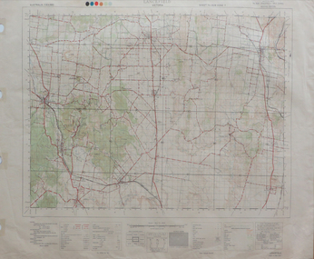
Map, Parish of Nunawading, 1892
Map copied from 'Directory maps - parishes and counties' 26 Nov 1892.Map copied from 'Directory maps - parishes and counties' 26 Nov 1892. Lithographed by G.S. Bonne[y]. Map includes roads, railway, stations, names of property owners. 2nd copy 'for copying'.Map copied from 'Directory maps - parishes and counties' 26 Nov 1892. maps, parish of nunawading -
 Bendigo Military Museum
Map - MAP HUE VIETNAM, C.1960’s
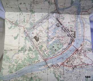
The city of Hue is in South Vietnam. The map was used by a member of the AATTV during the Tet Offensive in Thau Thien province. Map brought home from Vietnam by Murray Stanley Metherall. Refer 590.2.Colour printed map of Hue Citadel on paper. Aerial view of land, river and building outlines.hue, vietnam, tet -
Stawell Historical Society Inc
Map, Tourist Map of Grampians/Halls Gap and Surrounds, 1928
Tourist Map of Grampians/Halls Gap and Surroundsstawell, tourism -
Stawell Historical Society Inc
Map, Western Mining Corp / Stawell Joint Venture, Cross Section of Shafts. Long Section Newington - Three Jacks Looking West, August 1991
WMC/SJV Cross Section Western Mining Corporation Limited Stawell Joint Venturemining, gold, map -
 Bendigo Military Museum
Map - MAP of the WESTERN FRONT, Post 1918
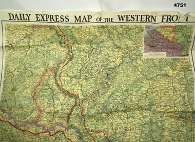
Map, “Daily Express map of the Western Front, colours greens, yellows & orange, the Western front is shown as red dots, inset in corner of areas, section of the map is missingmaps, western front -
Moorabbin Air Museum
Map (Item) - Middle East Egypt WW1 AFC Map
-
 Federation University Historical Collection
Map, New York Central Hudson River Map and Timetable
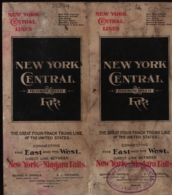
Henry Sutton is a talented world-wide accepted inventor with inventions relating to the telephone, photography, wireless, cars, motorcycles, and bicycles as well as many more inventions. Henry was also one of four brothers that ran the Sutton's Music Store after the death of their Father Richard Sutton. Henry Sutton taught Applied Electricity at the Ballarat School of Mines in 1883 to 1886.New York Central Hudson River Map and Timetable with red and black writing used by Henry SuttonUnion Steam Ship Company of New Zealand Limited stamp on the front.henry sutton, union steam ship company of new zealand limited, new york central, hudson river, map -
 Melbourne Tram Museum
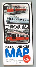
Map, Ministry of Transport, "Melbourne Transport Services Map - Tram, Train and Bus Services", 1976
Fold out map (27 sections 9 across x 3 deep), coloured of Melbourne's Tram and Bus routes, route numbers, rail lines, detailed for the central part of Melbourne and insert section for Frankston. On rear description of routes, private bus routes and map of Melbourne metro lines. Has contact details for bookings and lost property etc. Priced 20c Has a bus, silver train and a Z class tram on the cover. On bottom of outside cover, "No. 5 1976"On front cover in ink "5" in top right hand corner and "4 G 33 " along bottom edge.trams, tramways, melbourne, map, tram & bus services, railways, mmtb, minister for transport -
![Financial record - Account, State Electricity Commission of Victoria, State Electricity Commission of Victoria. [Electricity Account] Hailes Street Greensborough, 24/01/1966](/media/collectors/4f729f5697f83e03086015b8/items/6291b17c3072c0d5ab3eca2a/item-media/6291b2313072c0d5ab3ecdb0/item-fit-380x285.jpg) Greensborough Historical Society
Greensborough Historical SocietyFinancial record - Account, State Electricity Commission of Victoria, State Electricity Commission of Victoria. [Electricity Account] Hailes Street Greensborough, 24/01/1966
State Electricity Commission of Victoria. Electricity account for Mr W. A. Partington for Hailes Street Greensborough on 19 April 1966. This would be the property known as Alwyn, the Partington home on what is now Whatmough Park.Electricity account, black and red text on white paperHandwritten meter readings and cost.alan partington, william alan partington, partington family, alwyn, hailes street greensborough -
Whitehorse Historical Society Inc.
Map, Blackburn Lake, 1960s
Aerial photograph of Blackburn Lake Sanctuary 1960s.Aerial photograph of Blackburn Lake Sanctuary 1960s.Aerial photograph of Blackburn Lake Sanctuary 1960s.aerial photographs, blackburn lake sanctuary -
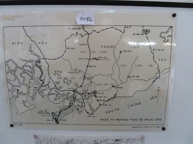 National Vietnam Veterans Museum (NVVM)
Map, Map of Phuoc Tuy Province - Vung Tau Special Zone, 1/05/1968 12:00:00 AM
Laminated map of Phuoc Tuy Province - Vung Tau special zone. Oulne of hamlets and military bases.AFV/F7-12/1188map, vung tau, 1 atf, 1 alsg -
 Rutherglen Historical Society
Financial record - Book, Mr A J Francis in Account Current With The Bank of Victoria Limited, 1925
Pass book used by Mr. Arthur John Francis, Merchant & Carrier. Ledger of business transactions in account with Bank of Victoria, Rutherglen Branch 1925-1930.Green cloth on cardboard covered book, brown corners and spine, white paper label on front.On front cover - "Mr. A. J. Francis/in account current with/the/Bank of Victoria Limited/ page 845"arthur john francis, francis family, bank of victoria, banking, accounts -
Stawell Historical Society Inc
Map, Concongella, County of Borung, 1929
Concongella, County of Borungstawell -
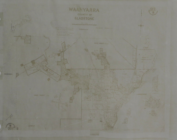 Federation University Historical Collection
Map, Waanyarra, not dated
Photocopy of mapwaanyarra -
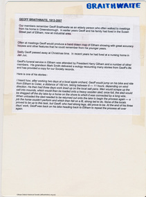 Eltham District Historical Society Inc
Map, Geoff Braithwaite, Braithwaite ma0p of Eltham circa 1920
A3 photocopy of hand drawn map of Eltham created by Geoff Braithwaite (1914-2008) of his memory of the township about 1920. It includes names of streets and property owners. Folder of information on Geoff Braithwaite Includes A3 photocopy of hand drawn map of Eltham with coloured shading of Eltham in 1920s and 1930sharry gilham collection, eltham, 1920, geoff braithwaite, map, smart family cottage, eltham cemetery, flora caroline braithwaite (nee gamble), geoffrey braithwaite -
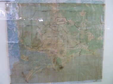 National Vietnam Veterans Museum (NVVM)
Map, Relief Map of Vietnam
Detailed relief map with words XA BIN BA + XUYEN MOC titled on information heading. Map information listed on lower portion.relief map, vietnam -
Stawell Historical Society Inc
Map, Crocodile Gold Corp, Photographic Aerial View of Big Hill showing underground workings and surface workings and proposed Big Hill Open Pit proposal, December 2014
Crocodile Gold Corp SGM photo Map showing Magdala Decline& Wonga Decline December 2014 Produced for Public Consultation over Big Hill Open Pit Proposal. Aerial Views Stawellmining, gold, map -
Glenelg Shire Council Cultural Collection
Financial record - Budget - Heywood Public Hall, 08/10/1959
Three page foolscap document, printed one side; expected budget for the Shire to complete and equip the Heywood Public Hall.heywood public hall, heywood, budget, finance -
University of Melbourne, Burnley Campus Archives
Map, Kororoit Creek Proposed ?, 1998
Composite photocopy so title partly obscured, by Thompson Berrill Landscape Design DWC No KC 13 Sheet 13 of 14 dated March 1998. Scale 1:200. Legend includes: Vegetation, Drainage and Flood Management Issues and Action, Water Quality, Stream System V? Issues, Primary Objectives (partially obscured).thompson berrill, landscape design, kororoit -
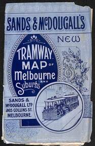 Melbourne Tram Museum
Map, Sands McDougall, "Tramway Map of Melbourne and Suburbs", c1906
Shows railways, cable and electric tram lines c1906. One of a number of maps produced by Sands McDougall of Collins St. Includes the MTOCo horse tram lines and the Caulfield horse tram lines. See items 2885 and 6573 for other editions. Yields information about Melbourne c1906 and its public transport lines. Map - folded sheet of paper 5 sections wide x 4 sections or folds deep contained within a light grey paper cover titled "Tramway Map of Melbourne and Suburbs"maps, melbourne, cable trams, tramways, railways, horse trams, nmetl, vr trams, sands mcdougall -
Stawell Historical Society Inc
Map, Local Map of Stawell and District
Local Map of Stawell and Districtstawell -
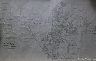 Melton City Libraries
Map, Coimadai County of Bourke, 1911
Town Plan of Meltoncouncil -
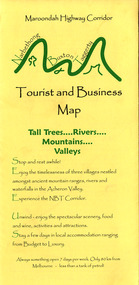 Marysville & District Historical Society
Map (Item) - Tourist and business map, Narbethong Community and Tourism Group, Narbethong Buxton Taggerty Tourist and Business Map, 04-2008
A tourist and business map of Narbethong, Buxton and Taggerty. This map was produced by the Narbethong Community and Tourism Group in April 2008. It was produced to promote the natural attractions, adventure activities and food trail from the Black Spur, through Narbethong, Buxton and Taggerty.A tourist and business map of Narbethong, Buxton and Taggerty.This publication has been produced by the Narbethong Community and Tourism/ Group (NCTG) to promote the natural attractions, adventure activities and food/ trail from the Black Spur, through Narbethong, Buxton and Taggerty./ the information provided in this publication has been supplied by the individual/ members. NCTG takes no responsibility for its accuracy./ April 2008narbethong, buxton, taggerty, victoria, australia, tourist and business map, narbethong community and tourism group, acheron valley, yarra track, wood's point, black spur, mystic mountains, the meeting of the waters, cathedral range, danico design counted cross stitch, things of sand & stone, buxton zoo nursery & oddz & enz, willowbank at taggerty, safe trek 4wd services, pnl 4wdriving, buxton trout and salmon farm, mystic mountains ski hire & outdoors, narbethong ski hire, highwood health centre, cathedral view natural therapies, narby cabinets, plants by shelian, gb timber, executive signs, rb automotive repairs, buxton car care, marysville towing & equipment hire, martyn slade building design, cathedral peak framing, black spur roadhouse & ski hire, tudor lodge roadhouse & ski hire, buxton roadhouse & persian bazzar, buxton post office general store & niche bar, igloo roadhouse, taggerty store, narby eggs, marapana agistment park, mantirri blueberry farm, carmyle farm, hazelwood hazelnuts, south cathedral lavender farm, cathedral cherries, black spur motel & caravan park, woodlands rainforest retreat, chestnut glade, black spur inn, wombat cottage, abbey lake luxury b & b spa cottages, blue views holiday cottages, camp narbethong, marapana farm stay b & b, mantirri blueberry farm b & b, little dene garden cottages, silverstream b & b cottages, nareen cabins, moondai farm b & b, south cathedral farm luxury b & b cottages, yarrolyn caravan park, sarsens rest, lomah retreat, pinjarra gardens, kingbilli country estate, henry viii manor house, buxton hotel, butters cafe of buxton, wagtail wines, little river wines, lanterns at willowbank, wirrawilla rainforest walk, wilhemina falls, the cascades -
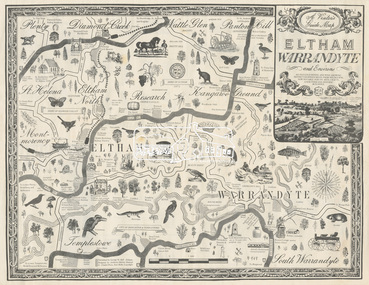 Eltham District Historical Society Inc
Map, George W. Bell, A Visitor's Guide Map; ELTHAM, WARRANDYTE and Environs, c.1969
Commissioned by George W. Bell, designed by Anthony Harvey. An old gold mining and wine growing district eighteen miles from Melbourne, now notable for its arts, crafts, good food and historic buildings. On the reverse side (of one copy only) is printed in 8 panels (3 half-folds) advertising for Montsalvat, Eltham; Setel Downs Coffee Kitchen Art Gallery, Kangaroo Ground; Country Art Store, Eltham; Alfred's Homestead, Warrandyte; Neville F Emmerson Estate Agent, Lower Plenty; Eltham Crafts. Monstsalvat, Eltham; Tantoon native plants and culinary herbs, Eltham; Flavour of Eltham, Shillinglaw Coattage Preservation Society; The Eltham Barrel; Potters Cottage, Warrandyte. In addition is provided by cateogory listing: POTTERY AND CRAFTS Country Art Store, Eltham Diamond Creek Handicrafts, Diamond Creek Eltham Crafts, Eltham John Mills, Eltham Potters Cottage, Warrandyte Setel Downs, Kangaroo Ground The Claypot, Warrandyte Warrandyte Quarries and Pottery, Warrandyte GOOD FOOD AND DRINK Alfred's Homestead, Warrandyte Geranium Parlour,. Research Inglenook, Warrandyte La Ronde, Eltham The Barrel, Research The Potters Restaurant, Warrandyte Setel Downs, Kangaroo Ground GALLERIES Hassall's Gallery, Research Lodge Gallery, Warrandyte The Bird Gallery, Eltham Royalat Gallery, Panton Hill PLANTYS, TREES AND SHRUBS Danson's Gardens, Research Dean's Orchids & Dahlias, Templestowe Diamond Vlley Trees & Shrubs, Warrandyte Jum Jum, Diamond Creek Parson's, Research Tantoon, Eltham Warran Glen, Warrandyte44..8 x 57.5 cm (Two copies) On the reverse side (of one copy only) is printed in 8 panels (3 half-folds) advertisingeltham, warrandyte, map, country art store, diamond creek handicrafts, eltham crafts, john mills, potters cottage, setel downs, the claypot, warrandyte quarries and pottery, alfred's homestead, geranium parlour, inglenook, la ronde, the barrel, the potters restaurant, hassall's gallery, lodge gallery, the bird gallery, royalat gallery, danson's gardens, dean's orchids & dahlias, diamond vlley trees & shrubs, jum jum, parson's, tantoon, warran glen, advertising, eltham barrel -
 Bendigo Military Museum
Map - Map Extract - Charterhouse of Mendip, John James Raisbeck, Unknown
Map extract showing the towns of Cheddar, Rodney Stoke, Westbury and a smaller town of Easton. The area depicted is part of Somerset, England. Map is hand drawn by J.J. Raisbeck date unknown. John James RAISBECK was born on 4 July 1880 at Christchurch New Zealand. He served 4 years (Citizen Military Force - CMF) in 9th Australian Light Horse Regiment in Central VIC with the rank 2nd Lieutenant. He was the first Australian appointed to the Survey Section RAE, on 16 April 1910, as a draughtsman which was his civilian profession, with the rank Warrant Officer, honorary 2nd Lieutenant. He was required to resign his commission in the CMF. He supervised the draughting work of the Section in Melbourne and was largely responsible for the mapping standards and specifications set in the production of the Cowes one-inch-to-one-mile military map, which became the enduring Australian standard. He was also responsible for supervising the printing of the maps by the Victorian Government Printer. He was appointed 2nd Lieutenant in the AIF Survey Corps draft on 6 December 1917 (from Melbourne) embarking for England on 22 December 17. He was attached to the Australian Corps Topographic Section in France from 21 April 1918 to 5 March 1919 serving as Second-in-Command and as Officer Commanding. He was promoted Lieutenant 15 October 1918, attending the AIF Survey School, Southampton in 1919, returning to Australia 23 June 1919, before his AIF appointment was terminated 17 July 1919. He went on to serve the Survey Section RAE and Australian Survey Corps, including in the Second World War, having been promoted Captain then Major and Officer Commanding Army Headquarters Cartographic Section until February 1940. He retired after 33 years of service to military survey, and after serving the Corps in two world wars, on 4 July 1943 with the retired rank Lieutenant-Colonel. He was the author of the article ‘A Short History of the Military Survey of Australia, 1907-1936’, published in The Australian Surveyor, Sept 1, 1937Map extract slightly larger than A4. Scale: One Inch to One and a half Mile. 1:31680, 9 x copiesSignature of "J.J. Raisbeck" bottom right-hand cornerroyal australian survey corps, rasvy, fortuna, army survey regiment, army svy regt, asr -
 Federation University Historical Collection
Map, Lancefield, 1947
Printed coloured map on paperlancefield -
Moorabbin Air Museum
Map (Item) - Map of Port Melbourne & Coode Island Rifle Range circa 1950s-60s
-
Stawell Historical Society Inc
Map, Borough of Stawell Parish of Stawell and Illawarra 10/06/1903, 10/06/1903
Department of Lands and Survey Map of Stawell with marked roads, allotments, physical landmarks. Found in Storage at ANZ Bank when the old archive was being cleaned out. Also shows Surveyed but unused roads. Showed where customers lived in StawellPholtolithograph Map - Paper on canvas backingBorough of Stawell. Parish of Stawell and Illawarra. County of Borong. Scale 8 Chains to 1 Inch. Scale 16 Chains to 1 Inch. Red Ink Writing, Purple and Blue.town -
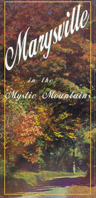 Marysville & District Historical Society
Map (Item) - Information brochure, Project Art & Photo, Marysville in the Mystic Mountains, Unknown
An information brochure on Marysville, the surrounding district and the natural attractions in the region published by Mystic Mountains Tourism.An information brochure on Marysville, the surrounding district and the natural attractions in the region published by Mystic Mountains Tourism.marysville, victoria, australia, information brochure, mystic mountains, mystic mountains tourism, cathedral range, lady talbot drive, cameron cascades, phantom falls, keppel falls, beech forest cascades, the beeches rainforest walk, the big tree, cumberland memorial scenic reserve, cambarville, cumberland falls, cora lynn falls, the big culvert, steavenson falls, lake mountain, marysville visitor information centre