-
 Bendigo Historical Society Inc.
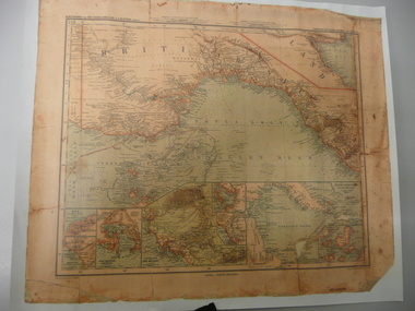
Map - STRAUCH COLLECTION: MAP BRITISCH PAPUA
Copy of original heritage map of ''Britisch Papua'' (N.G.) detailed & mapped by German (marine navigator) 'Gezeichnet von C.Barich & produced in the 'Langhans Deutscher Kolontal Atlas, Feb. 1893. Presented to German Society, 30.5.2008 by Mr P.Thwaites, Plans & Projects Officer (Digo 2008) Plus Society's laminated work copy of same map.map -
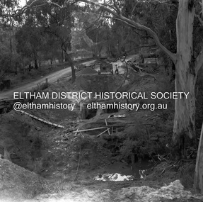
 Eltham District Historical Society Inc
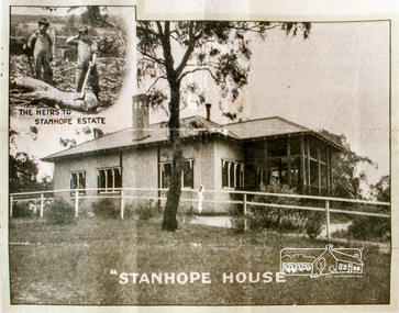
Negative - Photograph, Stanhope House
Stanhope Estate, Eltham; great suburban subdivisional auction, New Year's Day - Tuesday 1st January 1924 Subdivision of Stanhope property into 80 blocks; auction sale 1 Jan 1924 Roll of 35mm colour negative film, 3 stripsKodak CL 200 5093butcher, coghill and haughton, eltham, eltham railway station, railway station, real estate agent, stanhope estate, stanhope house -
 Numurkah & District Historical Society
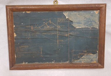
Plan - Plan of Numurkah Railway Station Fire Fighting Equipment
Part of railway collection from closed Numurkah Railway StationWooden Framed Blueprint Plan pasted onto a Masonite backing.VR Numurkah WS and Fire Fighting Equipment -
 Federation University Historical Collection
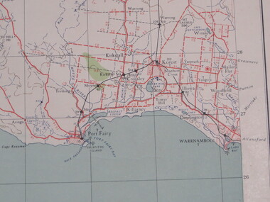
Map, Portland, 1941
Printed colour map on paperportland, port fairy, warrnambool, kirkstall, crossley, koroit, tower hill, woolsthorp -
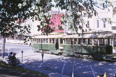 Ballarat Tramway Museum
Negative, Campbell Duncan, 1971
Yields information about tram operations and the area around City Loop in Sturt St.Colour positive (from a 35mm slide film) of No. 27 and 26 parked in the city loop, 1971 on a sunny day. Was from the end of a slide film strip and had a bit of the film holder remaining on the right hand edge. Has the parking meters on Sturt St in the photograph.trams, tramways, city loop, tram 26 tram 27 -
 Eltham District Historical Society Inc
Negative - Photograph, J.A. McDonald, Henley Road at Watsons Creek, Apr. 1961
Henley Road at Watsons Creek looking westerly along centreline from east abutment Early April 1961Record of various Shire of Eltham infrastructure works undertaken during the period of 1952-1962 involving bridge and road reconstruction projects, sometimes with Eltham Shire Council Project Reference numbers quoted. It was during this period that a number of significant improvements were made to roads and new bridges constructed within the shire that remain in place as of present day (2022). In many situations, the photos provide a tangible visible record of infrastructure that existed throughout the early days of the Shire. The album was put together by or under the direction of the Shire Engineer, J.A. McDonald.infrastructure, shire of eltham, bend of islands, cr. charis pelling, henley road, henley road bridge, kangaroo ground, oxley bridge, watsons creek, w.e. wolf, bridge construction, road construction, 1961-04 -
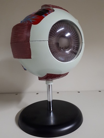 Vision Australia
Education kit - Object, 3D model of eye
This 3D model of the eye on shows the way they eye connects to the brain. The eyeball divides in half to study the interior and shows attachments for all six muscles that move the eyeball, the optic nerve, and surrounding blood vessels. Through the cornea the iris and pupil are visible. The iris, cornea and lens can be removed.1 pedestal mounted 3D model of the eye, hand painted in green, red, blue yellow and black equipment, model -
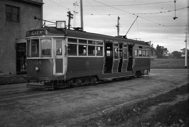 Melbourne Tram Museum
Negative - Set of 2, Wal Jack, 23/05/1941 12:00:00 AM
Set of two Black and white negatives, by Wal Jack, of L 104 (City Route 4) at the Carnegie Terminus - two views, one from each side of the tram. Photo dated 23-5-1941, in the Wal Jack album.trams, tramways, l class, carnegie, route 4, tram 104 -
 Moorabbin Air Museum
Plan (item) - C.A.C Compressor Mounting Power Unit
EX250006 -
University of Melbourne, Burnley Campus Archives
Plan, Classroom Locations Map, 1990-2000
Plan produced by VCAH Burnley with classrooms marked.vcah, burnley -
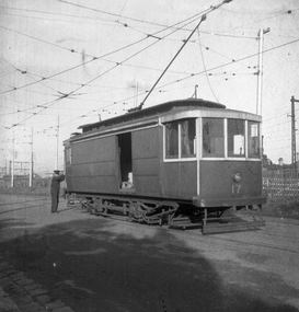 Melbourne Tram Museum
Negative, Wal Jack collection, Aug. 1940
Black and white negative, by Wal Jack, of Freight car No. 17 in Cameron St, Brunswick. Has the Coburg rail line in the background. Shows the 21E truck. Dated 8/1940. May not be a Wal Jack photograph as odd negative size. See also Reg item 5333 for another photo of this car at Brunswick.trams, tramways, freight tram, brunswick, cameron st, brill 21e, tram 17 -
 Bendigo Historical Society Inc.
Negative - BENDIGO CHINESE TEA HOUSE
Construction of the Bendigo Tea House, Nolan Street, Bendigo, alongside Lake Weeroona.buildings, commercial, tea house -
Bendigo Historical Society Inc.
Map - MINING PLAN, Circa 1880's
Mining Plan: showing the following companies: New Chum and Victoria Co., South Victoria Co., Lansell's 180, Victoria Quartz Mining Co.topic, mining, plans, mining in bendigo, new chum and victoria co., south victoria co., lansell's 180, victoria quartz ming co. -
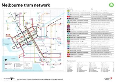 Melbourne Tram Museum
Map, Public Transport Victoria (PTV), "Melbourne tram network", "Victorian train network", May. 2017
A4 printed map, full colour published May 2017 titled on one side "Melbourne tram network" and the other "Victorian train network", showing the tram and train routes, and details of each route or line. Published by Transport for Victoria and PTV. Two copies held.trams, tramways, maps, railways, tramways, victoria, tram routes -
Bendigo Historical Society Inc.
Map - DERBY : COUNTY OF BENDIGO, 1959
Map. Derby, County of Bendigo, Inglewood, Tarnagulla, Woodstock, Leichardt, Bridgewater, Loddon River, Bendigo Railway, Calder Highway, Maldon to Bridgewater Road.By authority A.C. Brooks, Government Printer, Melbourne. Drawn and reproduced at the Department of Lands and Survey, Melbourne, 1959. Price 5/-. (number 59 in map cupboard 1)A.C. Brooks, Government Printer, Melbourne.map, bendigo, derby -
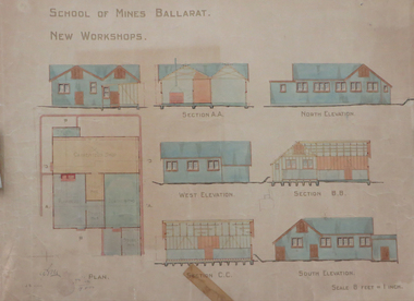 Federation University Historical Collection
Plan, Ballarat School of Mines New Workshops, 1912, 08/1912
Original plan for new workshops for the Ballarat School of Mines. Includes elevations and sections, abd has been coloured with watercolour. The new workshops housed carpenters shop, plumbers, blacksmihing and stores. ballarat school of mines, new workshops, carpentry, blacksmithing, plumbing, architectural plan, laboratory -
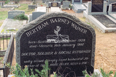 Eltham District Historical Society Inc
Negative - Photograph, Harry Gilham, Grave of Bertram Barney Wainer, Eltham Cemetery, Victoria, 1 Aug 2007
Bertram Barney Wainer born: -Dcotland 30th December 1928 died: - Victoria 16th January 1987 Doctor, Soldier & Social Reformer sadly missed & deeply loved husband of Jo - father of Dirk, Rory, Felice, Sean & Zoe -eltham cemetery, gravestones, memorials, bertram barney wainer -
 Melbourne Tram Museum
Negative, Wal Jack, c1944
Black and white negative, by Wal Jack, of S 169 in Buckley St Footscray. The building with the curved window (No. 97) remains in position near the intersection with Admiral St. The tram has the destination of Ballarat Road. Photo not dated in the Wal Jack album.trams, tramways, footscray, s class, buckley st, tram 169 -
 Bendigo Historical Society Inc.
Negative - BENDIGO CHINESE TEA HOUSE
Construction of the Chinese Tea House, Nolan Street, Bendigo. Beside Lake Weeroona.buildings, commercial, tea house -
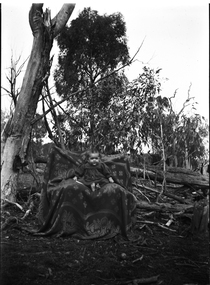 Wodonga & District Historical Society Inc
Negative - Haeusler Glass Negatives Collection - Baby in a chair in the bush, c1910
The Wodonga Historical Society Haeusler Collection provides invaluable insight into life in late nineteenth and early twentieth century north east Victoria. The collection comprises manuscripts, personal artefacts used by the Haeusler family on their farm in Wodonga, and a set of glass negatives which offer a unique visual snapshot of the domestic and social lives of the Haeusler family and local Wodonga community. The Haeusler family migrated from Prussia (Germany) to South Australia in the 1840s and 1850s, before purchasing 100 acres of Crown Land made available under the Victorian Lands Act 1862 (also known as ‘Duffy’s Land Act’) in 1866 in what is now Wodonga West. The Haeusler family were one of several German families to migrate from South Australia to Wodonga in the 1860s. This digital image was produced from one of the glass negatives that form part of the collection, probably taken by Louis Haeusler (b.1887) with the photographic equipment in the Wodonga Historical Society Haeusler Collection.This item is unique and has well documented provenance and a known owner. It forms part of a significant and representative historical collection which reflects the local history of Wodonga. It contributes to our understanding of domestic and family life in early twentieth century Wodonga, as well as providing interpretative capacity for themes including local history and social history.Digital image created from the Haeusler Glass negative collection. A young child sitting in the middle of the bush. The chair appears to be roughly made from surrounding wood and branches covered by a blanket.wodonga pioneers, haeusler family, glass negatives, dry plate photography -
 Melbourne Tram Museum
Negative, Wal Jack, 1/09/1941 12:00:00 AM
Black and white negative, by Wal Jack, of W5 801 turning from Lygon St into Holmes Road via Albion St, East Brunswick. The tram has the destination of East Coburg. The tram is fitted with a head light mask. There appears to be a solider on the tram, along with a trammies in uniform cap sitting down in the drop centre. The conductor could be on the other side of the tram. In the background is a tram stop shelter, a wall advert for the Liberty Theatre, a fire alarm pillar and a drinking fountain. Photo dated 1-9-1941 in the Wal Jack album.trams, tramways, east coburg, albion st, holmes st, headlight mask, shelters, tram 801 -
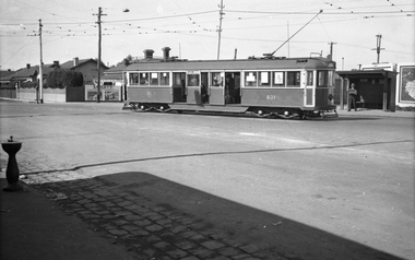
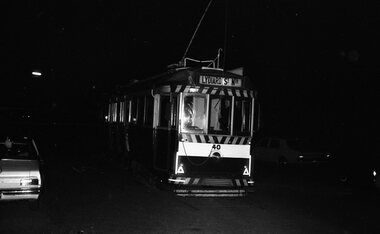 Ballarat Tramway Museum
Negative - Set of 13, Warren Doubleday, Final day of SEC tramway operations Ballarat - last tram from Sebastopol, 19/09/1971
Yields information about the last day of SEC Tramway operations in Ballarat and has a strong association with the archivist. Photos taken at night and show sing marked "The End"Set of 13 - 35mm negatives, of the last day of operations in Ballarat on 19-9-1971 taken by Warren Doubleday at night .1 - 40 at Sebastopol .2 - Some how I got onto the tram No. 40 fully loaded .3 - ditto .4 - yes there is always room for more. .5 - squish - lots of passengers .6 - ditto .7 - 39 and Scrubber ,8 - 40 running into the depot .9 - ditto .10 - running into the depot building .11 - The doors are closed .12 -The End 13 - The End trams, tramways, closure, depot, sebastopol, tram 40 -
Glenelg Shire Council Cultural Collection
Negative - Negative - Wye, near Nelson, Victoria, c. 1936
Negative for a black and white photograph. Image shows Wye, near Nelson. Nelson - Mt Gambier mail truck with trailer, parked outside a house. -
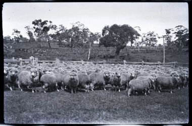 National Wool Museum
Negative - Sheep, J W Allen, 1928-1929
This negative was found loose in the first of three albums compiled and owned by J W Allen, Secretary of New South Wales Grazier's, and is associated with the New South Wales Graziers Association world tour of sheep 1928-1929. The album contains photographs of travel, sheep, farms, stations, people and landscapes from around the world. Locations include Naples, Port Said, Suez, Birregurra (Vic), Alexandra (Vic), Ballangeich (Vic), Keith (SA), Mt Gambier (SA), Buckland Park (SA), Tasmania, Winton (QLD), Sydney Harbour, Canberra (ACT), Toowoomba (QLD), Rockhampton (QLD), Tocal (NSW), Deepwater (NSW), Glen Innes (NSW), Longreach (QLD), Moree (NSW), Barraba (NSW) and Mudgee (NSW). Properties depicted include Mooleric, Turkeith, Woolongoon, Minadale, Crower Station, Merrindie, Koomooloo Station, Cappeedee, Koonoona, Rathmore, Ellenthorpe, Camden Park Station, Glenlegh, Strathmore Station, Ilparran Station, Binneguy, Midkin, Terlings, Ashley, Bereen, Plumthorpe, Mayvale and Havilah. The album was found in a clean out at the Great Southern Agricultural Research Institute and donated to the National Wool Museum, along with other related material such as photographs, glass lantern slides and ephemera.Black and white negative showing sheep in stockyards with trees and a power pole in the background. agriculture, sheep, farming, stations, research, breeding, photography, travel -
Bendigo Historical Society Inc.
Map - CAMPBELL COLLECTION: BENDIGO & DISTRICT MAPS, 22-3 29
Map. Marong, Parishes of Marong, Lockwood and Mandurang. Scale 20 chains to an inch. Total area 5106 acres. Crusoe Reservoir on right. Compiled in W.P.B. from Field Survey and Parish Plans (number 373 in map cupboard 1)G.W.Lmap, bendigo, allotments -
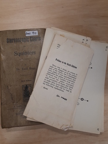 Vision Australia
Education kit - Object, A. Francke, Stereoscopic charts for squinters [by] Dr. Emil Hegg
A set of 70 (incomplete as full set believed to be 85 cards) black and white and colour stereoscopic charts, divided into series Includes geometric, pictorial and photographic examples of charts and Schlechteres Auge test. An instructional leaflet is also included. These featured images thought to strengthen the eye muscles.1 rectangular fawn cardboard box sleeve which contains specially printed cards with pictures and text6th editionequipment, emil hegg -
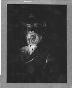 Churchill Island Heritage Farm
Negative - Negative of portrait of Samuel Amess
Churchill Island Heritage Farm has a large photograph collection dating from the nineteenth centuryNegative of portrait of Samuel AmessNilchurchill island, samuel amess -
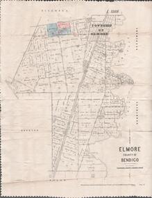 Bendigo Historical Society Inc.
Map - MAP. ELMORE COUNTY OF BENDIGO, 1918
Map. Elmore County of Bendigo. Diggorra. Burnewang. Ryunnymead. Egerton Photo-Lithographed at the Department of lands and Survey Melbourne, by W. J. Button. 4.7.18 -
Warrnambool and District Historical Society Inc.
Map - Tourist Map Collection: Warrnambool & District Tourist Maps, Philprint, Warrnambool
This is a diverse collection of Tourist Maps for the Warrnambool & District area. [.1] From information on this guide it dates from the mid 1970's. It appears to not have been commercially printed and includes details of attractions no longer operating in Warrnambool such as Warrnambool Aquarium and the Oasis Reptile Park and Zoo. [.2] Commercially printed Warrnambool tourist map (c mid 1980's) surrounded by advertisements for local businesses. [.3] Commercial printed December 1991 tourist map of Warrnambool and District includes a competition entry form [.4] Commercially printed tourist map aimed at children [.5] Walking map of Warrnambool and District [.6] Commercially printed Warrnambool tourist map (c mid 1980's) surrounded by advertisements for local businesses. This collection of maps from the mid 1970's to early 1990's gives an insight into what was available to assist tourists find their way around Warrnambool and District. They include advertisements for business operating during this period and include lists of available accommodation, eateries, and tourist attractions.[.1] Tourist Attractions In and Around Warrnambool two foolscap pages with two sides of type written information of local and district attractions. There is a Warrnambool City map with points of interest marked and a hand drawn district map; [.2]Commercially printed grid map of Warrnambool City surrounded by advertisements from local businesses. Reverse side has a district map and a map of the Warrnambool CBD surrounded by advertising. [.3] Brochure including small grid maps of Warrnambool and district listing accommodation providers and places of interest. Stylised blue & bright green design of Norfolk pines and sea. [.4] Children's treasure hunt map to Warrnambool There are two examples, one with blue edging (Jan 1986) and one with red edging (Aug 1993) Both have a circular logo with a stylised whale and lighthouse [.5] Walking maps of Warrnambool blue printed photo of four tourists walking coastline on the front cover. [.6] Commercially printed grid map of Warrnambool with a bright yellow inset of Warrnambool CBD main shopping centre. The map is surrounded by advertising for local businesses.warrnambool, tourist maps, warrnambool businesses, warrnambool accommodation -
Federation University Historical Collection
Plan, Shire of Buninyong Warrenheip water supply general management
The Shire of Buninyong was later amalgamated into the City of Ballarat.Map shows the 1966 district boundaries of Ballarat and the layout of properties and water pipes in Warrenheip 1966.Gutteridge, Haskins & Davey Consulting Engineers Shire of Buninyong Warrenheip water supply general management September 1966buninyong, vincent, warrenheip, gutteridge, haskins & davey, water supply