-
 Whitehorse Historical Society Inc.
Map, Yarra River, 1839
Copy of T.H. Nott's original survey of 'Yarra Yarra River' taken from 'Lilydale' by Grace Aveling.Copy of T.H. Nott's original survey of 'Yarra Yarra River' taken from 'Lilydale' by Grace Aveling. Covers area from Templestowe to Yarra Glen.Copy of T.H. Nott's original survey of 'Yarra Yarra River' taken from 'Lilydale' by Grace Aveling. maps, yarra river -
Whitehorse Historical Society Inc.
Map, M.M.B.W, c1962
Melbourne Metropolitan Area Base Map series sheet 235, covering part, Mitcham, Nunawading and Ringwood areas.Melbourne Metropolitan Area Base Map series sheet 235, covering part, Mitcham, Nunawading and Ringwood areas. Prepared by Department of Lands and Survey and Melbourne and Metropolitan Board of Works from State aerial Survey, June 1957 and Cadastral Survey information, August 1960. Scale 1:4,800.Melbourne Metropolitan Area Base Map series sheet 235, covering part, Mitcham, Nunawading and Ringwood areas. maps, mitcham, nunawading, ringwood, melbourne and metropolitan board of works, victoria. department of lands and survey -
 Bendigo Historical Society Inc.
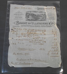
Financial record - Abbott Collection: Invoice
An invoice from Ullathorne & Co. leather, shoe mercery, grindery & general merchants dated June 30th 189? issued to Messrs. Abbott & Co. for a total of 13 pounds 6 shillings 9 pennies.invoice, abbott, business -
Glenelg Shire Council Cultural Collection
Plan - Plan - Portland, Victoria, n.d
Plan of Portland, compiled and drawn by T.E.C. Henry, Assistant Surveyor, Nov. 1893 -
Stawell Historical Society Inc
Map, MPI Mines, Plan View of Township Area 2003, 13/6/2003
goldShowing known old gold workings Stawell Gold Mines. 13 June 2003 1 : 7500 MPI Minesmining -
University of Melbourne, Burnley Campus Archives
Plan (Item) - Recreation Hall - Renovations
-
University of Melbourne, Burnley Campus Archives
Plan, Sue Parker, Planting Plan Contemporary Garden, 1989
Coloured plan by Sue Parker Sheet No 5 dated 23.05.1989.sue parker, gardens -
University of Melbourne, Burnley Campus Archives
Plan, 30 Lorne Pde Surrey Hills, c. 1980
Tracing paper copy, "Preliminary Site Plan," by "?N." and a rough sketch on paper. Scale 1:100. Possibly Landscape Design Project 1978.surrey hills, landscape design -
Port Melbourne Historical & Preservation Society
Plan - Fencing and gate, Borough of Port Melbourne, Arthur Victor Heath, Town Surveyor, 27 Jul 1888
Borough of Port Melbourne, 1888 design of fencing and wicket gate for block 52 (bounded by Liardet, Esplanade East and Pickles Streets, and, originally, arm of the Sandridge Lagoon).Signed by John Inglis, James McFarlane, Marcus Erling and witnessed by E.C. Crockford; embossed with seal of Borough (PM):Pencilled "A" top right:John Inglis began a signature bottom left then changed his mind ("Jo")engineering - fences, engineering department - borough of port melbourne, arthur victor heath, marcus earling, edward c crockford, town clerks, john inglis, james mcfarlane -
Stawell Historical Society Inc
Map, Stawell, County of Borung, 1959
Stawell, County of Borungstawell -
Clunes Museum
Plan - TITLE PLAN CAMPBELLTOWN, PARISH OF CAMPBELLTOWN, 1876
1 PAGE PHOTCOPY OF LAND TITLE PLANS 18752658 C 364 PARISH OF CAMPBELLTOWN COUNT OF TALBOT COMPILED BY CHARLES MCDONALS 1876campbelltown titles plan, photo-lithographic -
Bialik College
Plan (item) - Bialik College development, 1979-1980
Architectural plans of proposed Bialik College, 429 Auburn Road, Hawthorn East, created by architects Joshua and Mary Pila, May 1979-1980. Please contact [email protected] to request access to this record.1970s, 1980s, building and planning -
University of Melbourne, Burnley Campus Archives
Plan, The Museum of Modern Art at Heide, 1995
(1) Photocopy of Herb and Plant Location Map, Heide Kitchen Garden, plants numbered, no legend. (2) 1 tracing paper, 1 paper and 1 paper reduced size, Sketch Plan. Scale 1:1000. Drawn by JK 06.06.1995. (3) Photocopy of Heide Park and Art Gallery Grounds and Planting. Numbered Plant List, 1 Trees, 2 Shrubs.heide, museum of modern art, gardens -
 Numurkah & District Historical Society
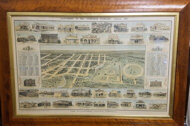
Map - Print in frame - Numurkah Township 1888, Supplement to the "Numurkah Standard" January 1888 View of Numurkah Victoria Australia
The late Hilda Morieson (very active in early Historical Society) owned the print. It was then passed on to Mary Morieson, then to Rosemary Kennet. It has been passed onto the Historical Society with permission from Ben Morieson, Hilda's grandsonLarge coloured print of supplement to Numurkah Standard 1888. Artist's view/impression of Numurkah streets (map) surrounded by artwork of a number of Numurkah businesses in the town and local district. The print is under glass in a faux-wood-grained framesee photo abovenumurkah standard, numurkah township map, numurkah businesses, 1888, print -
Whitehorse Historical Society Inc.
Map, Lake Road estate Blackburn, c1960
Plan of subdivision of Lake Road Estate, 36 sites.Plan of subdivision of Lake Road Estate, 36 sites. Agent: Mark Padgett & Co Pty Ltd.Plan of subdivision of Lake Road Estate, 36 sites. lake road estate, blackburn, lake road, blackburn, ottawa avenue, blackburn, anjaya court, blackburn, leons court, blackburn -
 Bendigo Historical Society Inc.
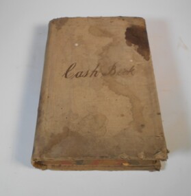
Financial record - Kelly and Allsop collection: cash book
1. Michael Peter Kelly (1853-1929) was born in Galway, Ireland and came to Australia in 1870. He was a director of many mines and was elected to the Bendigo Stock Exchange in 1882. At one point he was the chairman of the Exchange. He married Margaret Jane Carr in 1887 and they lived at "Norwood", Wills St., Bendigo. 2. Arthur Allsop (1856 - 1921) was a renowned athlete in many fields, including running, lacrosse, cricket, football and lawn bowls. He was an independent bookmaker and was elected to the Bendigo Stock Exchange in 1906. He was also a Past Grand Master of the MUIOOF lodge. After his time in Bendigo, and following the death of his wife in 1914, he moved to Melbourne and then Sydney where he died. For full biography see Item 6896.5Very large cash book for Kelly and Allsop stockbrokers. The book has 386 double pages, recording the daily cash movements. The book covers the period from September 1897 to December 1906. All pages are filled.Cash book on the front coverkelly and allsop, cash book, stockbrokers -
 Ringwood and District Historical Society
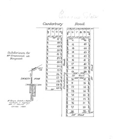
Plan, Paradise Estate Subdivision, Ringwood, Victoria - circa 1925
Paradise Estate layout also included in Land Sale Brochure Titled Eureka Plan Book - Seven Delightful & Valuable Ringwood Estates - circa 1925, Reg. No. 5100.Subdivision plan of Paradise Estate, Ringwood, showing allotments for sale, with typed page attached showing block sizes and prices.Locality plan showing land for sale south of Canterbury Road, 1 Mile south of Ringwood Railway Station. Subdivison includes Canterbury Road and Dandenong Road (later Wantirna Road). Surveyors - McKenzie Aisbett & Webber, surveyors & engineers, 440 Little Collins Street, Melbourne, Telephone Central 11540. Subdivision for Mr Grenwood at Ringwood. Additional typewritten price list showing footage, price per foot, and price per block for Lots No. 1 to 60. Paradise Estate layout also included in Land Sale Brochure Titled Eureka Plan Book - Seven Delightful & Valuable Ringwood Estates - circa 1925, Reg. No. 5100. -
Moorabbin Air Museum
Plan (item) - Albatross Monogram model 1/72 scale assy instructions
-
Clunes Museum
Map
Photocopy of sections of Clunes gold mines, South Clunes United Co. 770 Feet, South No.4 Shaft, looking SouthNilmap of clunes mine, south clunes united co., no.4 shaft -
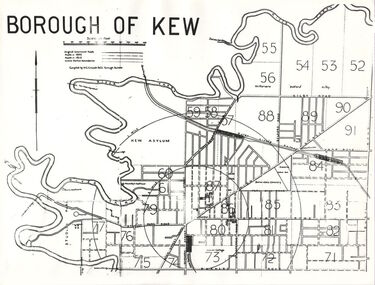 Kew Historical Society Inc
Plan, Borough of Kew, 1910
This work forms part of the collection assembled by the historian Dorothy Rogers, that was donated to the Kew Historical Society by her son John Rogers in 2015. The manuscripts, photographs, maps, and documents were sourced by her from both family and local collections or produced as references for her print publications. Many were directly used by Rogers in writing ‘Lovely Old Homes of Kew’ (1961) and 'A History of Kew' (1973), or the numerous articles on local history that she produced for suburban newspapers. Most of the photographs in the collection include detailed annotations in her hand. The overhead transparency is of a map produced by H.C. Crouch Borough Surveyor in 1910The Rogers Collection provides a comprehensive insight into the working habits of a historian in the 1960s and 1970s. Together it forms the largest privately-donated collection within the archives of the Kew Historical Society.An overhead transparency of a plan of Kew comparing the roads in 1860 with later roads constructed by 1910. Sections of the plan are marked with the location of particular buildings, farms or transport routes.Borough of Kewborough of kew, h.c. crouch -
Port Melbourne Historical & Preservation Society
Plan - Inner East, Station Pier, Ferry Terminal, Port of Melbourne Authority, Greg Lawrence, 1985
Plan of Station Pier - Inner East - Ferry Terminal. Cross section at rear passenger doors - Elevation gangway in stationary position. Port of Melbourne Authority 1985.transport - ferries, piers and wharves - station pier, melbourne harbor trust - port of melbourne authority -
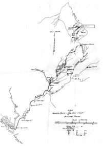 Tatura Irrigation & Wartime Camps Museum
Map - Map - Photocopy, New Guinea Escape Route
At the end of January 1942 there was only about 250 men left in Wau, as the women and children had been evacuated by air a little earlier. With no planes to take the men they had to make their own way to Port Moresby and then travel by ship to Australia. Some men went down to Salamaua and made their way along the north coast, but small groups also made their way over the Owen Stanley Ranges; rafting down the Lakekamu RIver to Yule Island and by boat to Port Moresby. Donor Vanessa Kiessling's Father was part of the second group, and had drawn a detailed map of their route. This might be the same route taken by Rev. Willi Hertle (Ref C0750)Photocopy of New Guinea map showing escape routePlan of surveyed route from Edie Creek to Bulldog Dromepapua new guinea, escape, map, wau, willi hertle, kiessling -
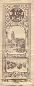 Federation University Historical Collection
Map, Ballarat and Creswick Districts, 1917, 14/03/1917
"... Three designs have been submitted to the Minister of Lands, at the Department's request, for the cover of a tourists' Guide book of the Ballarat and Creswick Districts. ..." (Ballarat School of Mines Principals Monthly Report, August 1916. Cat. No. 1110.12)A folded map of Ballarat and Creswick Districts which includes tourist destinations such as Creswick, Eureka Stockade, Sturt Street and Coliseum. Drawings are by Amalie Feild.ballarat, creswick, feild, amalie feild, ballarat town hall, park lake creswick, eureka memorial, university women -
 Federation University Historical Collection
Plan, Department of Crown Lands and Survey, Melbourne, Buninyong County of Grant, 23/07/1929
The plan was photo-lithographed at the Departmen tof Lands and Survey, MelbourneA parish plan of Buninyong, including Robert Scott's Mt Buninyong Pre-emptive Right, Mt Buninyong Public Park, Thomas Learmonth's land, John Learmonth's land, Scotchan's, Yendon. The Buninyong POst Office is Allotment 1. Pisition of tracks in 1859 have been marked on the plan in red.buninyong, scotchman's, mt buninyong, robert scott, clarendon, lal lal creek, yendon, warrenheip, yarowee, enfield, thomas learmonth, john learmonth, archibald fisken, g. schloo, george innes, peter inglis, durham lead, j. fry, j. forrest, parkin lee, buninyong recreation reserve -
Moorabbin Air Museum
Plan (item) - Bristol Aeroplane schematic drawings, Assembly of BoomSkin ....Rear Spar- Bottom.... title partly indecipherable
Bristol Aeroplane Company Ltd -
Moorabbin Air Museum
Plan (item) - Bristol Aeroplane 170 schematic drawings, Attachment of Reinforcing Plates At Front & Rear Spar Web Joints
Bristol Aeroplane Corporation Ltd -
Kew Historical Society Inc
Plan - Charteris Estate, Ivanhoe [East], 1927
Subdivision plans and real estate flyers/brochures reveal a number of aspects of urban development and history. The Kew Historical Society's collection of these plans, as well as advertisements extracted from magazines, cover key aspects of community development and architectural history of Kew and Kew Eat as well as surrounding suburbs. While most of the plans in the collection were gifted to the Society by the former City of Kew, a number of other plans and advertisements have been donated by individuals, of which this is an example.Original 4-page bifold handout advertising 43 residential lots for sale in the Charteris Estate subdivision in Ivanhoe [now classified as Ivanhoe East]. This brochure was created to sell the third section of the estate which it labels as 'The Most Superb Section'. Streets within the subdivision include: Burke Road North, McArthur Road, Castella Street, and the Government Boulevard. In addition to the overall plan spread across pages 2 and 3, each page includes a number of interesting photographs including: a number of the new Burke Road Bridge, a sports ground, Hoyts Picture Theatre in Ivanhoe, a croquet ground, and Ivanhoe shopping centre [named Motor Cross Junction].charteris estate - east ivanhoe (vic), subdivision plans -- ivanhoe east (vic.), d.c. mcarthur, charterisville -
University of Melbourne, Burnley Campus Archives
Plan, Plan of Richmond Park, 1872
Plan of Richmond Park L4461. Shows Horticultural Society's Garden without extra land used for Field Station (see 11.0363, but earlier). Photo-lithographed at the Department of Lands and Survey, 6th Sept. 1872.Handwritten notes on reverse and another railway line marked in pencil.richmond, parks, field station -
Moorabbin Air Museum
Plan (item) - Bristol Aeroplane 170 schematic drawings, Access Door Top Skin -Front Spar- Outer Wing
Bristol Aeroplane Company Ltd -
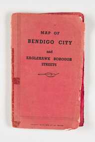 City of Greater Bendigo - Civic Collection
Map, Bolton Brothers Printers, Map of Bendigo City and Eaglehawk Borough Streets, Unknown
Produced by local company Bolton Brothers. Suitable for the glove box of car.Fold out map with a book style red and black printed front and back cover. Includes a three page index of street names and reference points. city of greater bendigo commerce, city of greater bendigo tourism