-
 University of Melbourne, Burnley Campus Archives
Plan, Power Tool Practical, 1980-1990
Tracing paper and paper copies of plan of where to put bolts and nails in a piece of construction work.tools, construction -
 Federation University Historical Collection
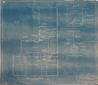
Plan, Ballarat School of Mines Supply and Installation of Hot Water Service, 1941, 12/08/1941
Plan for installation of an electric hot water service into the new workshops at the Ballarat School of Mines.ballarat school of mines, new workshops, hot water, buildings, archibald fisken -
University of Melbourne, Burnley Campus Archives
Plan, E.T. Brear, Glenferrie Primary School - Library/Art Craft Upgrade, 1987
Public Works Department, Victoria Site Plan No 87-579 A1. Scale 1:500. Drawn by E.T. Brear on 30.3.87.glenferrie primary school, e.t. brear -
University of Melbourne, Burnley Campus Archives
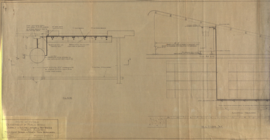
Plan, Detail of Sterilizing Trolley for New Plant Science Laboratory at Burnley Horticulture College, c. 1960
Plan by State of Victoria, Dept of Public Works. Drawn by R.M.department of public works -
 Federation University Historical Collection
Plan, Blueprint: Electric Hot Water Services, Ballarat School of MInes New Workshops, 1947
The Ballarat School of Mines is now part of Federation UniversityPlan (blueprint) for electric hot water services to new Ballarat School of Mines workshops ballarat school of mines, new workshops, electric hot water service, public works department of victoria, archectural plans -
 Kew Historical Society Inc
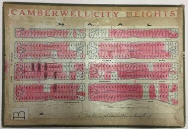
Plan - Subdivision Plan, Jas R Mathers Son & McMillan, Camberwell City Heights, 1922
"Following the 1919 amalgamation of suburban tramway trusts, an electrified tram service extended along Doncaster Road. Housing estates such as the 1919 Balwyn Park Estate, 1922 Hillcrest Estate and the Camberwell City Heights Estate, also 1922, quickly followed. These estates were built over by expansive suburban villas, set in fine gardens and along tree-lined streets. North Balwyn, largely constructed since 1933, was typified by even grander houses, many of them in the 'ocean liner' style and seen at their most distinctive in the Riverview Estate." (Source; 'Balwyn' in eMelbourne)Portions of subdivision plan mounted on both sides of cardboard sheet. Coloured pink, probably to show allotments sold. Area covered: Doncaster Road, Mountainview Road, Panoramic Road, Cityview Road, Longview Road, Riverview Road, Hillview Road, Bulleen Road. Includes location diagram showing railway lines and existing and proposed tram routes.Cardboard backing has advertisement for "Tillock's soluble coffee"subdivision plans -- camberwell (vic.), camberwell city heights subdivision -
Moorabbin Air Museum
Plan (item) - Plate - Modification And Serial SD 231
-
Moorabbin Air Museum
Plan (item) - C.A.C Details Of Receiver End Connections Refrigeration Circuit Details Sheet 2
-
Federation University Historical Collection
Plan, Ballarat Girls' Secondary School, Barkly Street, 1957
ballarat girls secondary school, ballarat east, barkly street -
Moorabbin Air Museum
Plan (item) - Bristol Aeroplane 170 schematic drawings, Repair Of Pistons ( Scheme P112)
Bristol Aeroplane Company Ltd -
Glenelg Shire Council Cultural Collection
Plan - Plan - Port of Portland Authority slipway, 12/05/1988
Front: '10' - black texta, top right corner 'Job no. 3081' black inkport of portland -
Port Melbourne Historical & Preservation Society
Education kit - Student Chalkboard, 1970's - 1992
Invented in the 1840's, chalkboards were commonly use for children in primary school education until the 21st century. Oblong green chalkboard on Masonite backing.education - primary schools, state school 1427 nott street -
Port Melbourne Historical & Preservation Society
Plan - Liardet Community Centre, Port Melbourne, Barry Merat, Architect, 1988 - 1989
Set of 3 preliminary drawings, plan for remodelling former Temperance Hall as new "Liardet Community Centre" (in use at this time as Senior Citizens' Centre and Children's Library) - copied from sketches then coloured. 1988.built environment - civic, port melbourne temperance hall, barry merat, liardet community centre -
Port Melbourne Historical & Preservation Society
Plan - Port Melbourne, 1882
Large, deteriorated 1882 plan of Port Melbourne, Parish of South Melbourne, County of Bourke - showing Town Lots. Pasted onto board.town planning, fishermans bend, sandridge lagoon, transport - railways -
 Warrnambool and District Historical Society Inc.
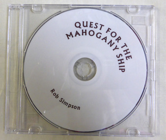
Education kit - CD, Quest for the Mahogany Ship, 2014
This CD relates the story of the quest to discover the Mahogany ship wreck which purportedly lies to the west of Warrnambool and is believed to be either a Spanish or Portuguese ship. It is named the mahogany ship due to the dark colour of the wood seen by early settlers.The story of the Mahogany ship is an integral part of Warrnambool's maritime historyThis a DVD with a plain white face with brown printing on it. ‘Quest For the Mahogany Ship, Rob Simpson’mahogany ship, warrnambool history, warrnambool shipwrecks -
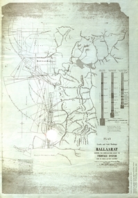 Federation University Historical Collection
Plan, Plan of Leads and Gold Workings at Baallarat Shewing the Complications Under the Frontage System, 1863
Facsimile of a plan held by the Public Record Office Victoria. Facsimile of a plan of Ballarat showing leads, gold workings an dthe frontage system.ballarat, mining, inkermann lead, golden point lead, robert davidson, terrible lead, white horse lead, frenchman's lead, little magpie lead, milkmaid's lead, woolshed lead, nuggety lead, blackman's lead, canadian lead, sailor's gully lad, nightingale lead, malakoff lead, black hill gully, pennyweight flat, black hill, winter's pre-emptive right, nelson company, great extended, great republic lead, cgt -
Port Melbourne Historical & Preservation Society
Plan - Setting temporary gangway at Inner East berth Station Pier for Tasmanian ferry Abel Tasman, Engineering Division, Port of Melbourne Authority, 1984
Plan: cross section at passenger doors showing deck levels - ship full lowest allowable tide (Drawing used in the setting up of temporary gangway at the Inner East berth of Station Pier for the vessel Abel Tasman), 1984melbourne harbor trust - port of melbourne authority, piers and wharves - station pier, abel tasman -
 Kew Historical Society Inc
Plan - Subdivision Plan, Harvest Home Estate, 1919
Pru Sanderson, in her groundbreaking ‘City of Kew Urban Conservation Study : Volume 2 - Development History’ (1988), summarised the periods of urban development and subdivisions of land in Kew. The periods that she identified included 1845-1880, 1880-1893, 1893-1921, 1921-1933, 1933-1943, and Post-War Development. These periods were selected as they represented periods of rapid growth or decline in urban development. An obvious starting point for Sanderson’s groupings involved population growth and the associated economic cycles. These cycles also highlighted urban expansion onto land that was predominantly rural, although in other cases it represented the decline and breakup of large estates. A number of the plans in the Kew Historical Society’s collection can also be found in other collections, such as those of the State Library of Victoria and the Boroondara Library Service. A number are however unique to the collection.The Kew Historical Society collection includes almost 100 subdivision plans pertaining to suburbs of the City of Melbourne. Most of these are of Kew, Kew East or Studley Park, although a smaller number are plans of Camberwell, Deepdene, Balwyn and Hawthorn. It is believed that the majority of the plans were gifted to the Society by persons connected with the real estate firm - J. R. Mathers and McMillan, 136 Cotham Road, Kew. The Plans in the collection are rarely in pristine form, being working plans on which the agent would write notes and record lots sold and the prices of these. The subdivision plans are historically significant examples of the growth of urban Melbourne from the beginning of the 20th Century up until the 1980s. A number of the plans are double-sided and often include a photograph on the reverse. A number of the latter are by noted photographers such as J.E. Barnes.The ‘Harvest Home Estate’ was advertised as being a subdivision in East Kew. Now, Campbell and Owen Streets on which the allotments were located are classed as being in Kew. The Estate included 11 residential allotments abutting the Outer Circle Railway line [at the end of Owen Street]. Understandably, the vendors focused on the availability of transport by tram, noting that the Estate was near the High Street tram terminus at the Harp of Erin. A small note on the subdivision advises that the Cotham Road tram was only 3 minutes away. The location – ‘The most elevated position in lovely Kew’ – was also promoted as an advantage.subdivision plans - east kew, harvest home estate -
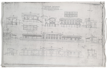 Federation University Historical Collection
Plan, Copy of a Plan of Serviceton Railway Station Building, 1888
The Serviceton Railway Station was completed in 1889 , with the Colony of Victoria and the Colony of South Australia sharing the cost. Ut was at Serviceton the the Victorian rail line and the Adelaide-Wolseley railway line of South Australia joined. The Railway Station included customs offices which were no longer necessary after the Federation of Australian States in 1901. ( https://en.wikipedia.org/wiki/Serviceton,_Victoria, accessed 30 August 2021)Copy of plan for the Serviceton Railway Linerailway, servicetone railway station, plan, serviceton -
University of Melbourne, Burnley Campus Archives
Plan - Photocopy, County, c.1930
Given to Archives by Emma Ferguson and Jo van Berkel who used it in preparation of their 1994 thesis on the history of the Burnley Gardens. Photocopy of a plan depicting Burnley College as it was in the 1930's. It shows the Pavilion and surrounding gardens, coops and yards, various small outbuildings. Shows the contours of the land in the northern section of the property bordering Swan St. Some additions and comments have been added to original document, mainly to do with sewerage and water supplyburnley college, pavilion, emma ferguson, jo van berkel -
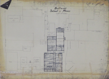
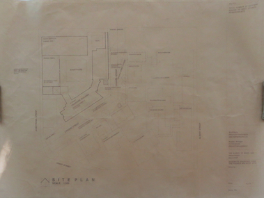 Federation University Historical Collection
Plan, Ballarat School of Mines Schematic Proposal for the Former Ballarat Brewery Site
The Project Manager for the Ballarat School of Mines Brewery Building was Peter Davies. The plan suggests the closure of Lydiard Street South Copy of the Site plan for the Ballarat School of Mines Brewery Building, built on the site of the former Ballarat Brewery. The plan shows where the new building sites in relation to all other buildings at the Ballarat School of Mines ballarat school of mines, brewery building, ballarat brewery, architectural plans -
Moorabbin Air Museum
Plan (item) - Bristol Aeroplane 170 schematic drawings, Installation Airspeed Pitot- Static Head ( Kollsman Type)
Bristol Aeroplane Company Ltd -
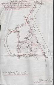 Bendigo Historical Society Inc.
Plan - MCCOLL, RANKIN AND STANISTREET COLLECTION: PLAN OF SURVEY OF DAM SITE, 1941
McColl Rankin & Stanistreet, Plan of Survey of Dam site, Part of Crown Allotment 98 Section C, City of Bendigo, Parish of Sandhurst, County of Bendigo. Signed by Garnet G Birch 1 Feb 1941. 33.5 x 43. Attached is a Copy of Field notes, Dam Site in Crown Allotment 198 Sec. City of Bendigo, Parish of Sandhurst. True Meridian, County of Bendigo, Area 0A 1R 16P. Signed Garnet G Birch, 1/2/1941. Drawn in red and black pen. 20.8 x 33. Both maps are for Deborah Extended Gold Mining Co. No Liabilityorganization, mining, deborah extended gold mining co nl, mccoll rankin & stanistreet, plan of survey of dam site -
Port Melbourne Historical & Preservation Society
Plan - Improvments, Beach Street, Port Melbourne, Beach Street Improvements, 9 Nov 1915
Plan for Beach Street improvements 1915 - hand drawn in ink and hand coloured.Signed by Heath and Chairman RH Gill - Scale altered in red ink from 2ft to the inch to 4ft to the inch (at bottom centre)built environment - civic, arthur victor heath, town clerks, richard henry gill, mayors -
 Kew Historical Society Inc
Plan - Subdivision Plan, J R Mathers & McMillan, Plan of Subdivision of Part of Crown Portion 83 at Kew : LP6669, 1923-1939
In 1888, in the section of Park Hill Road between Belmont Avenue and Normanby Road there was only one street running between Park Hill Road and Cotham Road. This was Park Road, later to be named Adeney Avenue. Subsequent 20th century subdivisions created the ‘through roads’ of Cecil Street, Wimba Avenue, Florence Avenue, Marshall Avenue, Uvadale Road, and Barrington Avenue. This subdivision represents an attempt by auctioneers, rather than town planners to create an urban environment from larger residential allotments or in many cases farmland. Existing streets such as Parkhill and Normanby Roads provided a convenient starting point for the surveyors, but the Road named ‘Street Street’ indicates the role of the private surveyor in creating streets. Given that a number of allotments are listed as sold on the plan, the street is presumably Cecil Street. Even those lots that had been sold do not quite match the dimensions of the blocks in this parcel of land today, indicating that either further subdivisions or boundary alterations occurred.Subdivision plans are historically important documents used as evidence for the growth of suburbs in Australia. They frequently provide information about when the land was sold as well as evidence relating to surveyors and real estate and financial agents. The numerous subdivision plans in the Kew Historical Society's collection represent working documents, ranging from the initial sketches made in planning a subdivision to printed plans on which auctioneers or agents listed the prices for which individual lots were sold. In a number of cases, the reverse of a subdivision plan in the collection includes a photograph of a house that was also for sale by the agent. These photographs provide significant heritage information relating house design and decoration, fencing and household gardens.The photograph may also be aesthetically significant depending on the importance of the photographic atelier.Hand-drawn subdivision plan of 19 lots facing Parkhill Road, Normanby Road, and an unnamed street [now Cecil Street] in Kew.Estate Agent notes in ink indicate those lots which had sold.subdivision plans - kew, parkhill road - kew, cecil street - kew, normanby road - kew, cecil street -kew, parkhill road - kew, normanby road - kew, crown portion 83 - kew -
 Federation University Historical Collection
Plan, Ballarat School of Mines 'Old Chemistry Building' Plan
Ballarat School of Mines is a predecessor institution of Federation University Australia. Two plans showing the Ballarat School of Mines Old chemistry Building and the Ballarat Technical Art School Building. It also shows the location of the Ballarat School of Mines Model Mine, Battery House, etc.ballarat school of mines, model mine, battery, old chemistry building, ballarat technical art school, laboratory, plan, architectural plans -
Moorabbin Air Museum
Plan (item) - Bristol Aeroplane 170 schematic drawings, Throttle Control Lever Wheel (Complete) Outboard
Bristol Aeroplane Company Ltd -
 Kew Historical Society Inc
Plan, Melbourne & Metropolitan Board of Works : Borough of Kew : Detail Plan No.1568, 1905
The Melbourne and Metropolitan Board of Works (MMBW) plans were produced from the 1890s to the 1950s. They were crucial to the design and development of Melbourne's sewerage and drainage system. The plans, at a scale of 40 feet to 1 inch (1:480), provide a detailed historical record of Melbourne streetscapes and environmental features. Each plan covers one or two street blocks (roughly six streets), showing details of buildings, including garden layouts and ownership boundaries, and features such as laneways, drains, bridges, parks, municipal boundaries and other prominent landmarks as they existed at the time each plan was produced. (Source: State Library of Victoria)This plan forms part of a large group of MMBW plans and maps that was donated to the Society by the Mr Poulter, City Engineer of the City of Kew in 1989. Within this collection, thirty-five hand-coloured plans, backed with linen, are of statewide significance as they include annotations that provide details of construction materials used in buildings in the first decade of the 20th century as well as additional information about land ownership and usage. The copies in the Public Record Office Victoria and the State Library of Victoria are monochrome versions which do not denote building materials so that the maps in this collection are invaluable and unique tools for researchers and heritage consultants. A number of the plans are not held in the collection of the State Library of Victoria so they have the additional attribute of rarity.Original survey plan, issued by the MMBW to a contractor with responsibility for constructing sewers in the area identified on the plan within the Borough of Kew. The plan was at some stage hand-coloured, possibly by the contractor, but more likely by officers working in the Engineering Department of the Borough and later Town, then City of Kew. The hand-coloured sections of buildings on the plan were used to denote masonry or brick constructions (pink), weatherboard constructions (yellow), and public buildings (grey). Plan No.1568 covers the area bounded by Cotham Road, John Street, Sackville Street, and Edward Street. Alfred Street and Rowland Street are in shown in the middle of the plan. The two most notable buildings shown are ‘St Helliers’, the home of the Dumaresq family, and St Hilary’s Church and school. While the colours used to indicate St Hilary’s are grey as in other civic/public buildings, the first St Hilary’s Anglican Church was at this stage constructed in weatherboard. At the left of the plan, facing Sackville Street is a house named ‘Glencara’. The 1988 ‘Kew Conservation Study’ recorded that “The first documentary evidence of this house comes from Rate Books which record that in 1893 a Mrs Treadway was the owner of this building with an N.A.V. of £81? At that date the occupier of the house was Charles B. Kelly, a clerk, while by 1910 Kelly had become the owner of the property described in that year ‘as a six-roomed stone, brick and wood house with stables and outbuildings’”. Contrary to this description, the 1905 plan indicates that the house was entirely constructed of masonry.melbourne and metropolitan board of works, detail plans, mmbw 1568 -
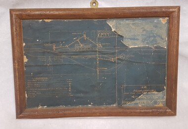 Numurkah & District Historical Society
Plan - Plan of Numurkah Railway Station Fire Fighting Equipment
Part of railway collection from closed Numurkah Railway StationWooden Framed Blueprint Plan pasted onto a Masonite backing.VR Numurkah WS and Fire Fighting Equipment -
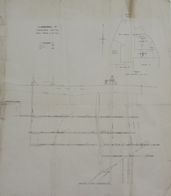 Federation University Historical Collection
Plan, Llanberris Co. Transverse Section, not dated
Printed transverse section of the Llanberris Companyunderground survey, llanberris mine, llanberris co, ballarat