-
 Bendigo Historical Society Inc.
Map - PLAN OF THE TOWNSHIP OF SANDHURST(PHOTOCOPY)
Map: Photocopy of a plan of the Township of Sandhurst. Dated 26 July 1854 ( number 141 in Map Cupboard 1)map, bendigo, city streets, township of sandhurst, early bendigo, city streets -
Whitehorse Historical Society Inc.
Map, State Savings Bank of Victoria, 1921
Map of Box Hill, Blackburn and Tunstall, 1921 from Australian Guide and Business Directory showing site of Box Hill branch of State Savings Bank of Victoria.Map of Box Hill, Blackburn and Tunstall, 1921 from Australian Guide and Business Directory showing site of Box Hill branch of State Savings Bank of Victoria.Map of Box Hill, Blackburn and Tunstall, 1921 from Australian Guide and Business Directory showing site of Box Hill branch of State Savings Bank of Victoria.maps, box hill, blackburn, state savings bank of victoria -
 Peterborough History Group
Map - Map of Peterborough House 1921, 1921
This hand drawn map of the buildings and out buildings was done for insurance purposes. It indicates which buildings are covered and which are uninsured. Significant as it shows a plan of the hotel as it was in 1921. Each building is labelled by its purpose, which provides an interesting insight into holidays of the time. For example, 'sleep outs' and external bathrooms. A4 photocopy of a hand drawn map of the buildings and out buildings comprising Peterborough House. Hand drawn map -
Bendigo Historical Society Inc.
Map - BENDIGO SHEET 5, May 1949
Map: Bendigo sheet 5 . Parish plan ( number 209 in Map Cupboard 1)map, bendigo, parish plan, bendigo -
 Bendigo Historical Society Inc.
Map - JACK FLYNN COLLECTION: HAYANMI, March 1953
Map: Parish of Hayanmi, County of Bendigo. Parish plan.By Authority: W.M. Houston, Government Printer. Drawn and reproduced at the Dept, of Lands and Survey, Melbourne, Victoriamap, bendigo, parish plan, hayanmi -
Stawell Historical Society Inc
Map, Sloanes & Scotchmans Company showing underground drives, c1900
Underground Workings Mapc1900Sloanes & Scotchmans Coy mining, gold, map -
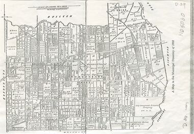
Glen Eira Historical Society
Map - CAPLES PLACE SUBDIVISION
This file contains a copy of a map of the CAPLES PLACE SUBDIVISION, undated and author unknown. The map provides the dimensions of roads and allotments in the area, including also handwritten notes from the original document and others written directly onto the copy.land subdivisions, documents, maps, glen eira, caples place, caples place subdivision, land surveys, orrong road, mulgrave road, prahran grove, somerset road, prahran grove, prahran grove, east walk, land allotments, town planning, garden road -
 Kew Historical Society Inc
Map, MMBW, River Yarra Beautification Schemes, c.1913
The Melbourne and Metropolitan Board of Works (MMBW) was established by an act of the Victorian Parliament in 1890 to prepare for and to implement a sewerage and water reticulation system across what was then inner Melbourne, its surrounding and middle distance suburbs, including Kew. The MMBW was disbanded in 1991.The map collection of the Kew Historical Society has at its core the historic maps assembled and originally stored in the City Engineer's Department of the City of Kew. These include maps in a number of scales. The vast majority of maps were produced by the MMBW in the first two decades of the twentieth century, and are solid working maps, backed by linen for durability. These maps are historically significant to Kew, the City of Boroondara and to the history of the development of state utilities in Victoria. A number of the Kew maps have additional details added by former municipal officers, including the levels reached by various floods. As these were working documents, information was added to them long after the period of their initial production and distribution.Map of the City of Kew showing part of the River Yarra Beautification Schemes. The map shows development to date and the flood levels reached in 1923 and 1924. This map may have been adapted from an earlier map, as most development in central Kew and Studley Park had occurred by this date yet numerous streets are not represented. Public buildings and institutions are clearly represented and named on the map as are significant public transport infrastructure (eg the Outer Circle railway).MELBOURNE AND METROPOLITAN BOARD OF WORKS / RIVER YARRA BEAUTIFICATION SCHEMES / SCHEME / SCALE 10 CHAINS TO AN INCHmelbourne & metropolitan board of works, mmbw maps, mmbw plans, city of kew, flood levels -- kew (vic.), cartography -
Whitehorse Historical Society Inc.
Map, City of Nunawading, n.d
Map of the City of Nunawading with streets and railway stations namedMap of the City of Nunawading with streets and railway stations named Scale 1 mile = 3.75 inMap of the City of Nunawading with streets and railway stations named city of nunawading, maps -
Bendigo Historical Society Inc.
Map - PLAN OF BENDIGO CREEK, 12th March 1873
Map:Hand drafted plan of the Bendigo Creek, covering from Scott St. White Hills to Alder St. Kangaroo Flat. Scale 2 chains to 1 inchGeorge R------- ? City Surveyormap, bendigo, bendigo creek -
 Whitehorse Historical Society Inc.
Map, Shire of Nunawading, 1892
Map of the Shire of Nunawading in the Municipal Directory of 1892e of NunawadingPhotocopy of a map of the Shirew of Nunawading in the Municipal Directory of 1892 showing land owners.Map of the Shire of Nunawading in the Municipal Directory of 1892e of Nunawadingmaps, shire of nunawading -
 Port Melbourne Historical & Preservation Society
Map - Plan of Melbourne, 1855
Framed copy of 1855 "Plan of Melbourne and its suburbs". Black frame. Some writing can be seen on left hand side of print.built environment, melbourne and metropolitan board of works -
Clunes Museum
Map - MAPS, AC BROOKS GOVERMENT PRINTER
.1 PARISH OF CLUNES, COUNTY OF TALBOT. STAMP: DRAWING OFFICE RECORDS COPY, STATE ELECTRICITY COMMISSION OF VICTORIA. ELECTRICITY DEPARTMENT (THIS PLAN MUST NOT BE TAKEN FOR FIELD USE. PLEASE DO NOT DEFACE) C71 ON LEFT BOTTOM CORNER, CLUNES SHEET 1 .2 MAP BECKWORTH COUNTY OF TALBOT. IN RED: B-61. L.4855. THE ALLOTMENTS COLOURED BROWN ARE FREEHOLD.1.2 DRAWN AND REPRODUCED AT THE DEPARTMENT OF LANDS & SURVEY MELBOURNE. PRICE 2/- .1 IN PENCIL ON BOTTOM ' 211 ' 20%parish of clunes, electricity supply department, beckworth -
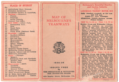 Melbourne Tram Museum
Map, Melbourne & Metropolitan Tramways Board (MMTB), "Map of Melbourne Tramways", 1934
Map booklet consists of three pages of bus and tram round trips, 3 center pages for a map of electric and cable trams, route numbers, and points of interest. Has 4 pages giving an index to routes and first and last trams to and from the City. Shows points where suburban routes are intersected by City routes. One page of places of interest. Dated 1934/35.Demonstrates methods of giving information to visitors to Melbourne and yields information about tram services at the time in Melbourne.Map - 2 octavo cards stapled and folded into 12 pages. All printing is in black with red headings and highlights except for the map which is in four colours.tramways, trams, mmtb, map, timetables, tourist trips -
Bendigo Historical Society Inc.
Map - PARISH OF SANDHURST 1961, 1961
At Bendigo Parish of Sandhurst. Sheet F.Dept of Lands and Surveybendigo, land sales, parish map -
Stawell Historical Society Inc
Map, Illawarra, County of Borung, 1955
Illawarra, County of Borungstawell -
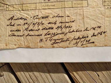
Port Melbourne Historical & Preservation Society
Financial record - Invoice, W Grant, Grocer & Wine & Spirit Merchant, Ross Street, Port Melbourne, 1910
Invoice form, W Grant, Grocer & Wine & Spirit Merchant 166-168 Ross Street, Port Melbourne, with Ideal Milk logo, found in minutes book of the Sea Bathing Clubsomeone has been figuring on back in pencil; many figuresbusiness and traders - wine and spirits, w grant - grocer -
Whitehorse Historical Society Inc.
Map, Blackburn Shopping Centre, 2006
Plan of Blackburn Shopping Centre c.1954, drawn by Bob Hoskins, showing businesses trading at that time.Plan of Blackburn Shopping Centre c.1954, drawn by Bob Hoskins, showing businesses trading at that time. Refer Tape NP2376 April 2001Plan of Blackburn Shopping Centre c.1954, drawn by Bob Hoskins, showing businesses trading at that time.blackburn shopping centre, hoskins furniture and floor coverings -
Bendigo Historical Society Inc.
Map - KIMBOLTON, No date Visible
Map: Kimbolton, County of Bendigo. Parish plan ( number 172 in Map Cupboard 1)map, bendigo, parish plan, kimbolton -
Bendigo Historical Society Inc.
Map - SEDGWICK : COUNTY OF BENDIGO, 1963
Map. Sedgwick, County of Bendigo, Strathfieldsaye, Eppalock, Lyell, Mandurang, Sutton Grange. By Authority A.C. Brooks, Government Printer, Melbourne. Drawn and reproduced at the Deparment of Lands and Survey, Melbourne. 1963. Price 2/-. (number 7 in map cupboard 1)A.C. Brooks, Government Printer.map, bendigo, sedgwick -
Bendigo Historical Society Inc.
Map - YARRAYNE : COUNTY OF BENDIGO, 6-1-32
Map. Yarrayne, County of Bendigo, Janiember East; Pompapiel, Salisbury, Bridgewater, Salisbury West, Powlett. Photo-Lithographed at the Department of Lands and Survey, Melbourne. Price 2/-. 6-1-32. (number 12 in map cupboard 1)H.J. Green, Government Printermap, bendigo, yarrayne -
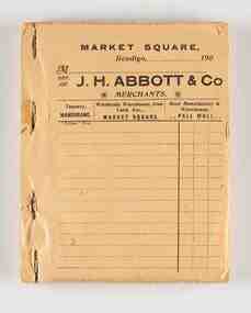 City of Greater Bendigo - Civic Collection
Financial record - Order book, RHS Abbott
Richard Hartley Smith Abbott was the step son of Joseph Henry Abbott and continued on in the family tradition of entering into business, becoming a successful business man. He also held asperations to serve on local council and was elected a representative in the Mandurang riding in the Shire of Strathfieldsaye in 1887, served as Mayor of the City of Bendigo from 1917 - 1918 and was Secretary of the Bendigo Art Gallery for over 20 years. Like this father he continued to build local industries with a particular interest in tanning selling products locally and exporting to London. The Tannery (in Tannery Lane, Mandurang) was one of the largest in the state. Unused order book designed to use carbon paper between two pages. Page numbers stamped in red. Black titles on each top page. Card back cover.city of greater bendigo commerce, mayor abbott -
Whitehorse Historical Society Inc.
Map, City of Whitehorse, 1/03/1995 12:00:00 AM
Map showing streets of the City of Whitehorse from Mullum Mullum Creek to the north to Highbury Road and Warrigal Road in the west, to Heatherdale Road in the east.Map showing streets of the City of Whitehorse from Mullum Mullum Creek to the north to Highbury Road and Warrigal Road in the west, to Heatherdale Road in the east. Prep. by Richard Meloni. Scale 1:15,000Map showing streets of the City of Whitehorse from Mullum Mullum Creek to the north to Highbury Road and Warrigal Road in the west, to Heatherdale Road in the east. city of whitehorse, mullum mullum creek -
Bendigo Historical Society Inc.
Map - SUBDIVISION OF STERNBERG'S ESTATE, 24/06/1920
Map: Subdivision of Sternberg's Estate, Crown Allotments 75, 76, 76A, 76B and 77, Parish of Rochester West, County of Bendigo. Parish plan Canvas backed ( number 133 in Map Cupboard 1)map, bendigo, rural, sternberg's, crown allotments 75, 76, 76a, 76b, 77, rochester west, county of bendigo -
Whitehorse Historical Society Inc.
Map, Boronia Road, Vermont, 1970
Enlargement of aerial photograph of Boronia Road, Vermont. State Aerial Survey 1970 Run 37Enlargement of aerial photograph of Boronia Road, Vermont. State Aerial Survey 1970 Run 37Enlargement of aerial photograph of Boronia Road, Vermont. State Aerial Survey 1970 Run 37boronia road, vermont, lusk drive, vermont, morack road, vermont south, allison court, vermont, trinian street, vermont, cosgrove street, vermont, mawson court, vermont, aerial photographs -
 Warrnambool and District Historical Society Inc.
Financial record - Ledger, Warrnambool Shire Council 1899-1918, Circa 1900
Provides a collection of letters to the President and Councillors of the Shire of Warrnambool from J. M. Crawley. The period covered is 1900 to 1918. It covers such topics as repairs to bridges, purchasing of equipment, complaints, applications for roads. Names of places and structures include Dennington Bridge, Cassidy’s Bridge, Warrumyea Bridge, Yangery, Purnim. Loose within the book is a letter from a W,M(H?) Clarke of Garvoc. The letters contained in this ledger provide information on a large range of works which were carried out in the Shire in the early 1900’sDark olive green fabric cover with tan spine and cornersMinute Book in gold lettering on red background on spine.warrnambool shire council 1899-1918, crawley j w crawley, warrnambool shire offices, warrnambool -
 Ringwood and District Historical Society
Map, Department of Mines, Plan of area applied for under the mining leases regulations in the township of Ringwood between Maroondah Highway and Mt. Dandenong Road. Mining District of Castlemaine, County of Mornington, Parish of Ringwood T Area 58(A) 2 (R)15(P) Acres, Roods, Perches. 1934, 20-Feb-34
Map of the township of Ringwood with subdivisions between Maroondah Highway and Mt. Dandenong Road. the area applied for on lease No.8210 by E.G.Browne.Mining District of Castlemaine, County of Mornington, Parish of Ringwood T Area 58(A) 2 (R)15(P) Acres, Roods, Perches.Buff coloured sheet foolscap with black printing showing map of the township of Ringwood between Maroondah Highway and Mt. Dandenong Road. Mining District of Castlemaine, County of Mornington, Parish of Ringwood T Area 58(A) 2 (R)15(P) Acres, Roods, Perches +Additional Keywords: Browne E.G. -
University of Melbourne, Burnley Campus Archives
Map - Photocopy, Monash University Clayton Campus, 1997
Photocopy of Map 475 from Melway Street Directory of Monash University, Clayton Campus. Sections enlarged.monash university, clayton campus -
Clunes Museum
Map
Map recovered from Estate sale at 31 Service Street, Clunes (former Fraser family residence and originally Shrigley residence)This item was donated by Catherine Jenkins/James Curzon from the Estate sale of Mr. Albert FraserMap of Clunes township printed on buff paperPrinted on front: In black ink, "Shire of Talbot and Clunes, Shire Eng. (name Illegible Boyd?) -/10/74map, clunes township, mr albert fraser, 31 service street -
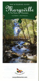 Marysville & District Historical Society
Map (Item) - Map and touring guide, Murrindindi Regional Tourism Association Inc, Marysville & The Mystic Mountains VICTORIA-AUSTRALIA, 08-2002
A fold out map and touring guide of Marysville and the surrounding district published in 2002 by Murrindindi Regional Tourism Association Inc.A fold out map and touring guide of Marysville and the surrounding district published in 2002 by Murrindindi Regional Tourism Association Inc.marysville, victoria, australia, map and touring guide, mystic mountains tourism, the beeches rainforest walk, lake mountain, cambarville, cathedral range state park, the cumberland, abbey green b&b cottages, anastasia fairytale cottage, ashlar cottage b&b, somerled mountain retreat, baree mudbrick cottages, blackwood cottages, camellia cottage, cathedral view b&b, cottage riverside, crossways country inn, dalrymples guest cottages, esa country ministries, hillcrest, keppels hotel motel, kerami house, lomatia lodge, lyell guest cottages, marylands country house, marysville caravan park, marysville holiday cottages, maryton park, melina cottage, moondai farm b&b, mountain lodge marysville, mount cathedral lodge, mystic mountains holiday cottages, nanda binya lodge, rendezvous on murchison, scenic b&b, the hermitage, tower motel, waratah house, willowbank at taggerty, woodlands of narbethong, keppels, lake mountain resort cafe, lanterns at willowbank, mantirri blueberry farm, marysville country bakery, the old woolshed cafe, clearstream olives, uncle fred & aunty val's old style lolly shop, acheron valley alpacas country store & gallery, bruno's art and sculpture garden, country touch, things of sand & stone, willowbank gallery, marysville auto & hardware, marysville newsagency & general store, marysville visitor information centre, narbethong visitor information centre, gallipoli park, keppels lookout, lady talbot drive, steavenson falls, steavenson river, taggerty river, acheron river, black spur trail riding centre, buxton trout farm, lake mountain resort ski hire, lake mountain ski school, marysville district country club, marysville ski centre, narbethong ski hire, rubicon horse riding, country touch tours, murrindindi regional tourism association inc