-
 Ringwood and District Historical Society
Legal record - Conditions of Sale (C.E.Carter), Ringwood, Lot 33 on Plan of Subdivision 10917, Mr S.T.Reiher and Mrs S.J.Nichols, 1947
Particulars and Conditions of Sale of Property , from Mr S.T.Reiher to Mrs S.J.Nichols. -
 Port Melbourne Historical & Preservation Society
Map - Track, Sandridge to Melbourne, 1840
Bromide of surveyor's sketch of the track to Melbourne from Sandridge (Liardet's Beach), 1840. Originals with Lands Department, Melbourne. (possibly the work of William Wedge Darke?)Slight processing stain upper right, '6' on backhotels, piers and wharves, william wedge darke -
Whitehorse Historical Society Inc.
Legal record - Land Title, Lemon Grove Nunawading, 1953
Certificate of Title: vol. 7827 fol. 071 to Tom SavageCertificate of Title: vol. 7827 fol. 071 to Tom Savage with transfers from October 1954 to 1970, recording subdivisionsCertificate of Title: vol. 7827 fol. 071 to Tom Savagesavage, tom, savage, grace beatrice, holmes, barbara ann, springfield road, nunawading, efron street, nunawading, savage court, nunawading, lemon grove, nunawading -
 Ballarat Heritage Services
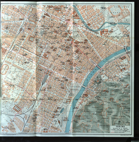
Map, Torino, 1924
Map of Torino, Italy in 1924italy, map, torino -
 Peterborough History Group
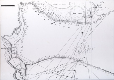
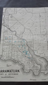
Map - Map of Curdies River Inlet district, Narrawaturk
Shows the allotment boundaries and names of landowners at the timeSignificant as it shows owners of rural land in the Peterborough area.Photocopy of an old mapHandwritten notes and markings on the map.peterborough, curdies river, curdies river inlet, old maps, maps, narrawaturk -
 Whitehorse Historical Society Inc.
Legal record - Report, Land Sale, 01/10/1855
Report of land sale by public auction, Parish of Nunawading, October 1855Report of land sale by public auction, Parish of Nunawading, October 1855Report of land sale by public auction, Parish of Nunawading, October 1855riley, patrick, holland, john, lobb, land sales -
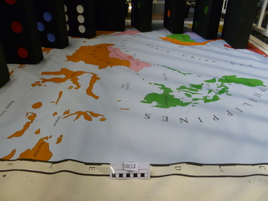
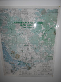 National Vietnam Veterans Museum (NVVM)
Map, Military Civic Action in Phuoc Tuy Province
Laminated map of civil action in Phuoc Tuy Province and Vung Tau Special Zone in the period of March 1970 to June 1971. Details housing, schools, hospitals & infrastructure projects.civil action, phuoc tuy, vung tau -
Glenelg Shire Council Cultural Collection
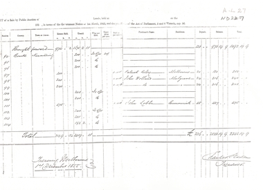
Legal record - Victorian Government Gazette, Victorian Government Gazette; Thursday, May 3 1951, 1951
Victorian Government Gazette. No 444, Thursday, May 3 1951 - the Commissioner's' Regulations 1951 -
Whitehorse Historical Society Inc.
Map, Mitcham, 1880s?
Hand drawn map of area north and south of Whitehorse Road and South of Canterbury Road c.1880-1900.Hand drawn map of area north and south of Whitehorse Road and South of Canterbury Road c.1880-1900. Probably sketched by a McClare descendant. Includes locations and names of settlers of that time.Hand drawn map of area north and south of Whitehorse Road and South of Canterbury Road c.1880-1900. whitehorse road, mitcham, mitcham road, mitcham, l l vale road, vermont, canterbury road, mitcham -
Stawell Historical Society Inc
Map, 1959
Bulgana, Counties of Borung & Riponstawell -
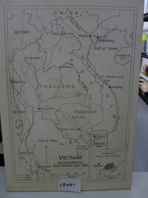 National Vietnam Veterans Museum (NVVM)
Map, Vietnam in Continental Southeast Asia 1965, 1965
Mounted black and white map of Southeast Asia with country borders and major cities marked. There is a highlight of Phuc Tuy Province in the lower righthand cornerCountries, cities and gulfs anotated map title - Vietnam in Continental Southeast Asia 1965map, phuc tuy -
Port Melbourne Historical & Preservation Society
Map - City of South Melbourne, 1854 - 1884
Detailed map of City of South Melbourne. Date uncertain. Shows early configuration of river and docks."South Melbourne, Sheet 2"emerald hill, town planning -
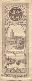 Federation University Historical Collection
Map, Ballarat and Creswick Districts, 1917, 14/03/1917
"... Three designs have been submitted to the Minister of Lands, at the Department's request, for the cover of a tourists' Guide book of the Ballarat and Creswick Districts. ..." (Ballarat School of Mines Principals Monthly Report, August 1916. Cat. No. 1110.12)A folded map of Ballarat and Creswick Districts which includes tourist destinations such as Creswick, Eureka Stockade, Sturt Street and Coliseum. Drawings are by Amalie Feild.ballarat, creswick, feild, amalie feild, ballarat town hall, park lake creswick, eureka memorial, university women -
Whitehorse Historical Society Inc.
Legal record - Land Title, Certificate of Title, 1932
A letter to Mr A. Roy Charlesworth, valuer, Shire of Blackburn and Mitcham, accompanying four copies of certificates of title.A letter to Mr A. Roy Charlesworth, valuer, Shire of Blackburn and Mitcham, accompanying four copies of certificates of title.A letter to Mr A. Roy Charlesworth, valuer, Shire of Blackburn and Mitcham, accompanying four copies of certificates of title.shire of blackburn and mitcham, orchard grove, blackburn south, simla street, mitcham, orient avenue, mitcham, land titles, charlesworth, albert roy, canterbury road, blackburn south, halls parade, mitcham, furness, albert george, kemp, frank, lemke, gustav robert, huffey, emily may -
 Moorabbin Air Museum
Essay (item) - Echo Hotel November: A Flying Adventure, Author Possibly E.H.x.Neill
-
Ballarat Tramway Museum
Legal record - Legal Document, Ballarat Tramway Preservation Society (BTPS), "Administration and Management Regulations 1973", Jul. 1973
1238.1 - Photocopy on heat sensitive paper of the BTPS "Administration and Management Regulations 1973", four sheets with hand written notes on two of the pages. Has date and initials in top right hand corner "GN 13/7/73" Describes the management arrangements of the BTPS with a General Manager, Traffic Manager and Engineering Manager. 1238.2 - Typed foolscap sheets with background notes on the formation of the Administration and Management Regulations with diagrams of proposed and present arrangements. Three sheets of typed notes and two sheets of organisational structure notes. Prepared by C.E. Croft - 12/7/1973. Has date and initials in top right hand corner "GN 13/7/73" Has date and initials in top right hand corner "GN 13/7/73" in black ink.trams, tramways, btps, btps management, regulations, organisational structure -
Ringwood and District Historical Society
Legal record - Conditions of Sale (C.E.Carter), Ringwood - Lot 30, Plan of Subdivision No 10507, J Roberts to M McEwan, 1926
Particulars and Conditions of Sale of Property , from John Roberts to Michael McEwan -
 Vision Australia
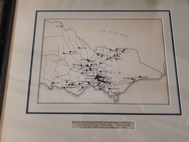
Map - Object, Victorian railways map
A black and white map of Victoria showing the railway lines where mail is transported and the individual towns listed next to the dot that provides location of such. Underneath is written "Map of Victoria showing the localities beyond the suburbs of Melbourne to which library books are sent to blind members. Books are carried over the railways FREE there is no charge to the readers." Through the work of Tilly Aston, braille postage was provided free by the Victorian Railways which greatly assisted the Braille Library in reaching members who resided outside of Melbourne. This map was produced to show the extent of the work by the Victorian Association of Braille Writers and the need for reading materials across the state.Paper of Victorian railway lines mounted in framevictorian association of braille writers, marketing -
 Melbourne Tram Museum
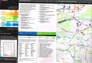
Map, Metlink, "City of Boroondara - Local Travel Guide - July 2008", Jul. 2008
Map, Guide book, Pamphlet, 21 fold, pocket size, titled "City of Boroondara - Local Travel Guide - July 2008" detailing public transport services in the City. Includes map of the tram, train networks, tickets information, tram traction , Connex SMS updates and info on Metlink including contact details. Has a detail map showing services in the city and adjacent overlap area of buses, trams and trains including route numbers. See Reg Item 2283 for Moonee Valley version,trams, tramways, city of boroondara, map, guides, bus services, metlink, connex -
Ringwood and District Historical Society
Legal record - Conditions of Sale (C.E.Carter), South Warrandyte , Lot 8, 9, 10,11, 12 on Plan of Subdivision 15580, Mrs E.Milner and Mr K.G.Thomson, 1944
Particulars and Conditions of Sale of Property , from Mrs E.Milner to Mr K.G.Thomson, Register No 15580. -
 Ballan Shire Historical Society
Map - Map. Kerrit Bareet, Department of Lands and Survey, Kerrit Bareet. County of Grant, 08/1944
A map of the Kerrit Bareet area within the County of Grant showing properties and names of owners in 1944.Significant to people researching land usage and ownership. Also those researching families in the area at that time.A map of Kerrit Bareet in the County of Grant. Black printing on buff coloured paper. Details roads, rivers, railways, property boundaries and names of property owners and towns and villages. The map is easily readable although there is some physical damage and that and the borders have been reinforced with sellotape. Shows a Scale in Chains and Price 2/.gordon, bungal, kerrit bareet, lal lal, moorarbool river, warrenheip, bungaree, wallace, moorarbool west -
 Bendigo Military Museum
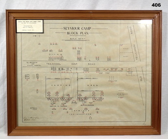
Map - PLAN, FRAMED
LT COL BENJAMIN THOMAS ROY CHADD No's 10594, VX20311, 1st and 2nd AIF. Refer 2039 for Service History also 2034P. Plan, detailing Seymour Camp Block Plan, Signals 7th Aust Div Camp 1940, re LT COL BENJAMIN THOMAS ROY CHADD. Tan coloured frame, glass front, cardboard backing, detail of camp layout, scale 160' = 1".documents - maps/plans, military history - army, frames -
 Melbourne Tram Museum
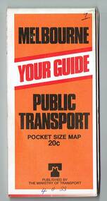
Map, Ministry of Transport, "Melbourne Transport Services Map - Tram, Train and Bus Services", 1977
Fold out map (27 sections 9 across x 3 deep), coloured of Melbourne's Tram and Bus routes, route numbers, rail lines, detailed for the central part of Melbourne and insert section for Frankston. On rear description of routes, private bus routes and map of Melbourne metro lines. Map No. 7, 1977. Has contact details for bookings and lost property etc. Priced 20c. 1977, route 59 showing as terminating opposite Essendon Airport.On front cover in ink "" in top right hand corner and "4 G 33 " along bottom edge.trams, tramways, melbourne, map, tram & bus services, railways, mmtb, minister for transport -
Stawell Historical Society Inc
Map, Department of Lands and Survey Melbourne, Swinton Estate. Parish of Riachella. County of Borong, 3-08-1921
Shows part of Warranook TrainwayA1 Printed Map With Cloth Backing. Annotations in Red Ink W.J. Butson 3-8-21farming -
Ringwood and District Historical Society
Legal record - Conditions of Sale (C.E.Carter), Ringwood , Lot 100 on Plan of Subdivision 8022, Mr A.J.Loughnan & Mr J.A.O'Keefe To Mr C.E.Carter, 1947
Particulars and Conditions of Sale of Property , from Mr A.J.Loughnan & Mr J.A.O'Keefe to Mr C.E.Carter, Register No 8022. -
 Whitehorse Historical Society Inc.
Legal record - Document, Australian Brick and Tesselated Tile Co, 1886
Copies of the original Memorandum of Association dated 15 May 1886Copies of the original Memorandum of Association dated 15 May 1886 The first Memorandum of Association of the Company, which became the largest industry in Mitcham, with a reputation extending overseas.Copies of the original Memorandum of Association dated 15 May 1886australian tesselated tile co. pty ltd, tile factories, brickworks -
Port Melbourne Historical & Preservation Society
Map - MMBW, c. 1894
Melbourne and Metropolitan Board of Works 1894, Plan number 18 Segments Shown: Between 322 - 486 Smaller scale map incorporating piers, lagoon and town north to beyond boundaryIn pencil: "7/7/94" (Which is the copywrite date)engineering - board of works, piers and wharves - railway pier, piers and wharves - town pier, sandridge lagoon, transport - tramways, transport - railways, gasworks, built environment -
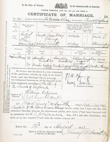 Mission to Seafarers Victoria
legal record (item) - Register, Marriage Register No. 2, Circa 1921
The register records all weddings that took place in the Mission to Seamen's church between the 15th of August 1921 to the 1st of September 1923. Each of the ten pages is a completed certificate of marriage, including all the information necessary to legalise a marriage under Commonwealth law.This register documents the weddings that took place in the Mission to Seamen church between 1921 and 1923.Front cover: REGISTER NO 2 (underlined) / NOS 12-21 (underlined) (AUG 15TH 1921 TO SEPT 1ST 1923). all handwritten in black ink. In the top left and right hand corners the Mission to Seamen logo has been stamped in blue-purple ink.wedding, marriage, register, 1921-1923, marriages, dio-marriages -
 National Vietnam Veterans Museum (NVVM)
Map, Flawed Theory, 2009
Large PVC 1965 political map of South East Asia with nine large dominoes attached'Asia South East Political 1965'domino theory, 3rar, jones, geoffrey r -
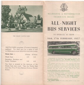 Melbourne Tram Museum
Map, Melbourne & Metropolitan Tramways Board (MMTB), "All - Night Bus Services", Feb. 1957
Map - 10 fold printed on heavy paper, three colours - black, green and yellow - shows 13 different routes. MMTB Routes printed in green ink. The route through Abbotsford St North Melbourne has been hand coloured in. Gives a table of route numbers. On rear gives a description of each route, departure times, fares, and list of fares. Has a photo of the Wattle Park Chalet, and a list of green fees of the golf course. On the front when folded, has MMTB logo, photo of bus, dated to operate from 16th or 17th Feb. 1957. 2 copies held. 1539i2 - low res tiff file. 1539i3 - high res tiff file - 71MB 1539i4 and i5 - scan of rear of sheet - jpgstrams, tramways, all night services, buses, wattle park, routes, fares