-
 Bendigo Historical Society Inc.
Map - NEILBOROUGH, 15/10/1877
Map: Neilborough, County of Bendigo. Parish plan (number 301 in map cupboard 1)map, bendigo, parish plan, neilborough, elysian flat -
Moorabbin Air Museum
Plan (item) - Couguar Turbojet Engine 022-010A - GAF
-
 Ringwood and District Historical Society
Plan - Proposed Ringwood East Railway Station, VR Ringwood-Croydon (Dublin Road) - 1923
Technical drawing of "Proposed Station At 16Mls 38Chs 89Lks (Dublin Road)" inluding boundary line, red shaded platform with station buildings, and green shaded possible future "up" track. Surrounding streets include Dublin Road, Patterson Street, and subsequent hand-written additions of Railway Avenue, Lawrence Grove, Stanley Avenue, Wenwood Street, and Lois Street. Land title details of Patterson Street properties mainly illegible.Scale: 40'=1". Possible future (platform) extension for 8 car trains (and) extension for 10 car trains. -
Moorabbin Air Museum
Manual (Item) - Includes major repairs to the De Havilland Sea venom A.P 4360 vol.6, Minor repairs to the sea venom
-
Moorabbin Air Museum
Manual (item) - Griffon 74 Engine - Schedule of Spare Parts
-
Moorabbin Air Museum
Manual (Item) - Meteor Wing Tip Camera installation
-
Moorabbin Air Museum
Manual (Item) - Illustrated Parts Breakdown - Mirage Iiio
Description: 566 pages. Published by Avions Marcel Dassault Breguet Aviation. Published 18/8/1977. Chapter II, SECTION 0. AAP 7213.001-4-1 Level of Importance: World. -
Moorabbin Air Museum
Manual (Item) - Collins Avionics Digital & multi-functional Processor Unit DPU-85/86 MPU-85/86
-
Moorabbin Air Museum
Manual (item) - CAC Commonwealth Aircraft Corporation - Data on Tests and Operations of the Self Contained Starter, Data on Tests and Operations of the Self Contained Starter
Commonwealth Aircraft Corporation -
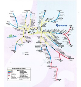 Melbourne Tram Museum
Map, VicTrip, Melbourne rail network - Connex and M>Train, 2000
Map - Colour print - of Melbourne's railway station network, shows the Connex and M>Train areas, zones, V/Line Metcards, Premium stations - used in Fares and Travel Guide - 2000 and 2001 Map - see Reg Item 2508. Also used in poster Reg Item 2514.trams, tramways, connex, map, melbourne, railways, m>tram, connex -
Moorabbin Air Museum
Manual (Item) - Bell Kiowa Illustrated Parts Breakdown, Bell 206B-1 Illustrated Parts Breakdown
AAP 7210.010-4 -
Moorabbin Air Museum
Manual (collection) - B24 power plant instruction manual, Instruction Manual Power Plant B-24D Airplane
Technical instructions and diagrams for B-24D engine -
Moorabbin Air Museum
Manual (collection) - Atar Engine Descriptive And Functional Handbook - Text, Atar Engine Descriptive And Functional Handbook - Text Chapter IV
No. 51List of parts and modifications to those parts -
Moorabbin Air Museum
Manual (Item) - Commonwealth Aircraft Corporation F404 Engine Components - Spares, F404 Spares Manual
Commonwealth Aircraft Corporation -
Moorabbin Air Museum
Manual (item) - Cylinder, Piston, Piston Ring and Gasket Set Application List - SFN-880-1 - January 1990, Lycoming Cylinder, Piston, Piston Ring and Gasket Set Application List - SFN-880-1 - January 1990
-
Moorabbin Air Museum
Manual (Item) - Bristol Type 170 (Freighter) List of ground equipment and special tools and Specimen Inspection Schedule Mark 21 Series
-
Port Melbourne Historical & Preservation Society
Plan - Fire bell tower, Port Melbourne, 16 Jan 1890
Plan, elevation of fire bell tower, 1890 (Borough of Port Melbourne)Town Clerk's stamp, plus signatures of Town Clerk E. CLARK, contractor John BRODERICK and E CROCKFORD (witness).:"Fire Bell Tower", on backfire and fire services, edward clark, town clerks, john broderick, edward john crockford -
Moorabbin Air Museum
Manual (Item) - Operating manual aircraft systems chapters 5 to 12, Ansett Boeing 737
-
 Kew Historical Society Inc
Plan, Melbourne and Metropolitan Board of Works, Melbourne & Metropolitan Board of Works : Borough of Kew : Detail Plan No.1294 & 1295, 1904
The Melbourne and Metropolitan Board of Works (MMBW) plans were produced from the 1890s to the 1950s. They were crucial to the design and development of Melbourne's sewerage and drainage system. The plans, at a scale of 40 feet to 1 inch (1:480), provide a detailed historical record of Melbourne streetscapes and environmental features. Each plan covers one or two street blocks (roughly six streets), showing details of buildings, including garden layouts and ownership boundaries, and features such as laneways, drains, bridges, parks, municipal boundaries and other prominent landmarks as they existed at the time each plan was produced. (Source: State Library of Victoria). This plan forms part of a large group of MMBW plans and maps that was donated to the Society by the Mr Poulter, City Engineer of the City of Kew in 1989. Within this collection, thirty-five hand-coloured plans, backed with linen, are of statewide significance as they include annotations that provide details of construction materials used in buildings in the first decade of the 20th century as well as additional information about land ownership and usage. The copies in the Public Record Office Victoria and the State Library of Victoria are monochrome versions which do not denote building materials so that the maps in this collection are invaluable and unique tools for researchers and heritage consultants. A number of the plans are not held in the collection of the State Library of Victoria so they have the additional attribute of rarity.Original survey plan, issued by the MMBW to a contractor with responsibility for constructing sewers in the area identified on the plan within the Borough of Kew. The plan was at some stage hand-coloured, possibly by the contractor, but more likely by officers working in the Engineering Department of the Borough and later Town, then City of Kew. The hand-coloured sections of buildings on the plan were used to denote masonry or brick constructions (pink), weatherboard constructions (yellow), and public buildings (grey).The streets and built structures in MMBW Detail Plan 1294 & 1295 were surveyed in 1903 and released to contractors in 1904. This plan is one of two in the collection where the lithographers amalgamated two separate plans. Both plans include sections of Studley Park. Dominating the south and west corners of Kew Junction are the Clifton and Kew Hotels. The Kew Hotel, owned by Patrick O’Shaughnessy was one of the oldest in Kew. MMBW plans were amended over time to take account of new subdivisions such as that which created Merrion Place. Of the four mansions shown in Studley Park Road, three remain – ‘Field Place’, the home of Frances Henty, ‘Leaghur’ and ‘Darley’. ‘Byram’ (later ‘Goathland’, then ‘Tara Hall’) was an architectural marvel. Designed in 1888 by E.G. Kilburn for the paper magnate George Ramsden, it was demolished in 1960. While an earlier sale of the southern section of Byram had created Tara Avenue in 1927, the demolition of the house in 1960 enabled the extension of Tara Avenue northward.melbourne and metropolitan board of works, detail plans, mmbw 1294, mmbw 1295, cartography -
Moorabbin Air Museum
Manual (Item) - RAAF AAP 7212.005-5 Loading and Balance Summary CT-4A Airtrainer
-
Moorabbin Air Museum
Manual (Item) - General Electric T58-GE-5, T58-GE-10, T58-GE-400, & CT58-140 Training Manual. SE1-478
-
Moorabbin Air Museum
Manual (item) - Jindivik MK 4A Manual Volume 2
System Manual For Test Equipment 256TPO635-S11 -
Bendigo Historical Society Inc.
Map - KAMAROOKA ALLOTMENTS, 7/06/1894
Map: Parish of Kamarooka Allotments, County of Bendigo. Parish plan (number 288 in map cupboard 1)map, bendigo, allotments, kamarooka, allotments -
Moorabbin Air Museum
Manual - CAC Commonwealth Aircraft Corporation, Numerical Drawing List CA 19
-
Moorabbin Air Museum
Manual (Item) - Canberra Metalurgy
Description: Technical Memo No 322 M58/70 Fatigue braking of a main Landing Wheel 10 page A.R.L. Dec 1970 Author: Cox A.F. Level of Importance: National. -
University of Melbourne, Burnley Campus Archives
Plan, Business Services, Burnley Campus, 27.11.2020
plan of burnley campus, university of melbourne -
Moorabbin Air Museum
Manual (Item) - CAC Bendix Engineering Standards, Bendix Engineering Standards Vol. 1
Commonwealth Aircraft Corporation -
Bendigo Historical Society Inc.
Map - PARISH OF SANDHURST SHEET 5A, 1970
Map: Parish of Sandhurst Sheet 5A, County of Bendigo. Parish plan ( number 161 in Map Cupboard 1)map, bendigo, parish plan, parish of sandhurst, county of bendigo -
Moorabbin Air Museum
Manual (item) - Aircraft Log Books, Department of Defence EE510 Aircraft Log Book
Department of Defence -
 Kew Historical Society Inc
Plan, Melbourne & Metropolitan Board of Works : Borough of Kew : Detail Plan No.1563, 1905
The Melbourne and Metropolitan Board of Works (MMBW) plans were produced from the 1890s to the 1950s. They were crucial to the design and development of Melbourne's sewerage and drainage system. The plans, at a scale of 40 feet to 1 inch (1:480), provide a detailed historical record of Melbourne streetscapes and environmental features. Each plan covers one or two street blocks (roughly six streets), showing details of buildings, including garden layouts and ownership boundaries, and features such as laneways, drains, bridges, parks, municipal boundaries and other prominent landmarks as they existed at the time each plan was produced. (Source: State Library of Victoria)This plan forms part of a large group of MMBW plans and maps that was donated to the Society by the Mr Poulter, City Engineer of the City of Kew in 1989. Within this collection, thirty-five hand-coloured plans, backed with linen, are of statewide significance as they include annotations that provide details of construction materials used in buildings in the first decade of the 20th century as well as additional information about land ownership and usage. The copies in the Public Record Office Victoria and the State Library of Victoria are monochrome versions which do not denote building materials so that the maps in this collection are invaluable and unique tools for researchers and heritage consultants. A number of the plans are not held in the collection of the State Library of Victoria so they have the additional attribute of rarity.Original survey plan, issued by the MMBW to a contractor with responsibility for constructing sewers in the area identified on the plan within the Borough of Kew. The plan was at some stage hand-coloured, possibly by the contractor, but more likely by officers working in the Engineering Department of the Borough and later Town, then City of Kew. The hand-coloured sections of buildings on the plan were used to denote masonry or brick constructions (pink), weatherboard constructions (yellow), and public buildings (grey). This plan covers the area between Barkers Road, Wrixon Street, Sackville Street and Brougham Place, much of it now occupied by Carey Baptist Grammar and Preshil schools. This was an area of large and prestigious homes in 1903, some with formally laid-out gardens, such as ‘Tower Hill’ and ‘Opawa’. ‘Kalimna’ was built in 1890-91 for William H. Jarman, an accountant, and ‘Blackhall’ at the same time for W.H. Roberts. Blackhall was to be acquired by the Salvation Army in 1915 and renamed ‘Catherine Booth Girls’ Home’. The Home accommodated girls, aged between 4 and 16. Kalimna and Blackhall are of significance as typical and intact late Victorian mansions and as such are two key Victorian buildings to have been built in Kew. Both Blackhall and Kalimna are now part of Preshil. ‘Fairview’ was for a long time occupied by the Sisters of St. Joseph of Cluny as a care home for the elderly, but it is now part of Carey Grammar School, as are the grounds of ‘Wagga Merne’, ‘Weemutta’, ‘Blakely’, ‘Daheim’ and ‘Mildura’ (later ‘Urangeline’), the last being particularly impressive in 1903, with a tennis court, conservatory, outhouses, and two bathrooms!melbourne and metropolitan board of works, detail plans, mmbw 1563, cartography