-
 Kew Historical Society Inc
Plan - Willsmere Park Estate, Kew, 1926
Subdivision plans and real estate flyers/brochures reveal a number of aspects of urban development and history. The Kew Historical Society's collection of these plans, as well as advertisements extracted from magazines, cover key aspects of community development and architectural history of Kew and Kew Eat as well as surrounding suburbs. While most of the plans in the collection were gifted to the Society by the former City of Kew, a number of other plans and advertisements have been donated by individuals, of which this is an example.Original 4-page, bifold subdivision plan of the Willsmere Park Estate, Kew. The 1926 land sale advertised '40 superb villa allotments' on the 'Yarra Heights'. Streets within the subdivision included: Willow Grove, Kilby Road, Elm Grove and Belford Road. The double page spread on pages 2 and 3 shows the detailed plan of the 40 lots, surrounded by public parkland [Willsmere Park] and the Kew Golf Links. By the time that this version of the plan was released, only the lots on Willow Grove and Kilby Road remained. willsmere park estate -- kew (vic.), subdivisions - kew (vic.), subdivisions -- kew east (vic.), willsmere park -- kew east (vic.) -
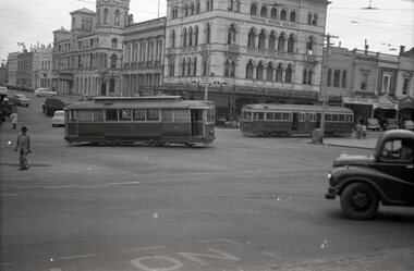 Ballarat Tramway Museum
Negative, Wal Jack, early 1950's
Yields information about tram services at the corner of Sturt and Lydiard Sts and the appearance of the buildings.Negative and Digital images of the Wal Jack Ballarat Negative file of tram No. 30 turning from the south side of Sturt St into Lydiard St North with a bogie tram 3? on the south side. IN the background is Craig's Hotel, ANZ bank, the National Mutual and the C Marks & Co building. There is a sign for Stonyfell wines.trams, tramways, sturt st, lydiard st, tram 30 -
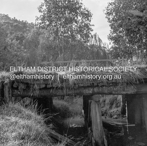 Eltham District Historical Society Inc
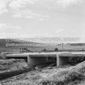
Negative - Photograph, J.A. McDonald, Heidelberg-Kinglake Road, 11 May 1961
Yow Yow Creek bridge 11 May 1961Record of various Shire of Eltham infrastructure works undertaken during the period of 1952-1962 involving bridge and road reconstruction projects, sometimes with Eltham Shire Council Project Reference numbers quoted. It was during this period that a number of significant improvements were made to roads and new bridges constructed within the shire that remain in place as of present day (2022). In many situations, the photos provide a tangible visible record of infrastructure that existed throughout the early days of the Shire. The album was put together by or under the direction of the Shire Engineer, J.A. McDonald.1961-05-11, heidelberg-kinglake road, infrastructure, bridge construction, shire of eltham, yow yow creek -
University of Melbourne, Burnley Campus Archives
Plan, Burnley College Faculty of Agriculture Forestry and Horticulture
site plan -
Moorabbin Air Museum
Plan (item) - Bristol Aeroplanes 170 schematic drawings, Assy of Pressure HD Centre Plane
The Bristol Aeroplane Company -
University of Melbourne, Burnley Campus Archives
Plan, Kirsten Strutt, Design for Mr & Mrs Swan 7 Gascoyne Street Canterbury 3126, c. 1990-2000
Coloured plan by Kirsten Strutt. Scale 1:100.canterbury, kirsten strutt -
Federation University Historical Collection
Plan, Ballarat School of Mines New Workshops Hotwater Supply, 1941
Service plan for new workshops at the Ballarat School of Mines.ballarat school of mines, new workshops, buildings, hotwater service, plans -
 Ballarat Tramway Museum
Negative, Wal Jack, late 1945
Yields information about the appearance of the ex Melbourne bogie trams during the initial period of operations in Ballarat.Negative and Digital image of the Wal Jack Ballarat Negative file of bogie car, most likely ex Melbourne 117, future 22 at the intersection of Wendouree Parade, Ripon and Webster Streets. Tram has the destination of city. Late 1945. It would appear that the sides of the tram have been painted but not the rear end, still has the MMTB War time markings on the tram. trams, tramways, wendouree parade, new trams, webster st, ripon st, bogie trams, tram 22 tram 117 -
 Federation University Historical Collection
Plan, City of Ballarat (Part) (Ballaarat East), 08/05/1928
Crown Cadastral Plan showing Governement Roads, Crown Parcels, Dimensions, Crown grantees, dated of grants, etc in Ballarat East. The plan shows features such as Bakery Hill, Canadian Station, recreation reserves, timber reserves, Yarrowee Creek, Black Hill Reserve, Eureka Reserve and Garden, Orphan Asylum, Rifle Butts Reserve, Ballarat Woollen Mill, Ballarat Observatory, Sovereign Hill Recreation Reserve, Specimen Vale, Market Reserve, Cemetery WGS 84 Centroid 37 degrees 33' 55" S 143 degrees 52' 38" E E.W. Extent; 5 km N-S Extent; 4 kmmap, plan, ballarat east, ballarat woollen mill, ballarat railway line, ballarat railway station, eureka reserve, eureka cemetery, ballarat orphanage, russell square, bakery hill -
Glenelg Shire Council Cultural Collection
Negative - Negative - View of Portland Harbour, 1961
NEGATIVE FOR BLACK AND WHITE PHOTOGRAPH. View of Portland Harbour from Henty Beach. Fishermens Breakwater on right, Ocean Pier, Railway pier on left, fishing boats at anchor, surveying pegs on beach in foregroundzillah maschmedt, portland harbour -
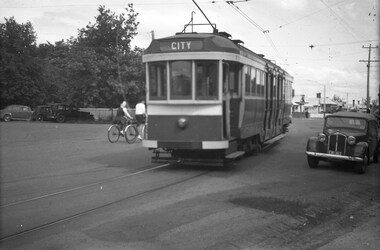
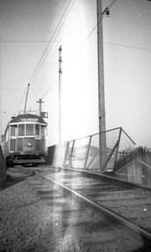
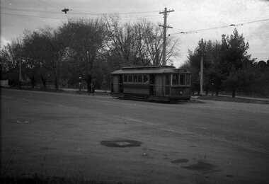 Ballarat Tramway Museum
Negative, Wal Jack, late 1930's or early 1940's
Yields information about the tram that was to become the gold tram in 1951, in general passenger service.Negative and Digital image of the Wal Jack Ballarat Negative file of No. 23 inbound in Sturt St West to the city, about to stop to pick up two school girls at a tram stop. Has Victoria Park in the background. trams, tramways, sturt st west, victoria park, schools, tram stops, tram 23 -
 Eltham District Historical Society Inc
Negative - Photograph, J.A. McDonald, Healesville-Yarra Glen Road, c.May 1958
‘U’ slabs Paul Creek bridge, Tarrawarra Contractor WolfRecord of various Shire of Eltham infrastructure works undertaken during the period of 1952-1962 involving bridge and road reconstruction projects, sometimes with Eltham Shire Council Project Reference numbers quoted. It was during this period that a number of significant improvements were made to roads and new bridges constructed within the shire that remain in place as of present day (2022). In many situations, the photos provide a tangible visible record of infrastructure that existed throughout the early days of the Shire. The album was put together by or under the direction of the Shire Engineer, J.A. McDonald.infrastructure, shire of eltham, bridge construction, 1958-05, healesville-yarra glen road, paul creek bridge, w.e. wolf, tarrawarra -
University of Melbourne, Burnley Campus Archives
Negative - Colour negatives, Plant Materials, 1996-1997
Miscellaneous rolls of negatives. (1) Plant materials and some students. (2) Dip. Semester 2 Wk 5 Drought Tolerant Plants, Evergreen Trees-Sally R, Ornamental Plants-Indoor Plants 1st Yr, Native Trees 3.5.96, Ferns & Grasses Ruth 2nd negs, Degree/Diploma Coastal Plants Wk 2, Plant Materials II 1997 Wk 9 Cut Flowers. (3) Late Autumn Winter, Aust Shrubs 1, Landscapes-Excursion?, Eucalypts 1, Weeds. (4) Aust Trees & Shrubs, Nature-like landscapes. (5) RMIT Year 1 Semester 1 Plant Materials Week1 Shade Tolerant, Week 2, Week 3, Week 4 Drought Tolerant, Week 5 De-oxygenated Soils, Week 6 De-oxygenated, Week 7, Week 9, Week 10 Ferns & Grasses, Week 11 Exotic Evergreen trees & shrubs, Week 12 Australian Trees.plant materials, students, drought tolerant plants, evergreen trees, ornamental plants, indoor plants, native trees, ferns, grasses, coastal plants, eucalypts, weeds, australian trees, australian shrubs, shade tolerant plants, de-oxygenated soils, exotic evergreen trees -
 Eltham District Historical Society Inc
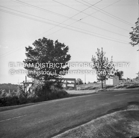
Negative - Photograph, J.A. McDonald, Eltham-Yarra Glen Road (Main Road, Eltham), Oct. 1959
The land situated on the northwest corner of Main Road and Brougham Street was originally owned by Justus Jorgensen of Montsalvat. He sold the property and it was purchased for Mobil Service Station (since demolished in the 1990s). This photo was taken by Council in response to a request from the garage proprietor to cut down the trees, presumably based on a claim of visibility. Council's investigation indicated the trees on either corner did not impede visibility which was reported in Council minute 23 Nov 1959.Record of various Shire of Eltham infrastructure works undertaken during the period of 1952-1962 involving bridge and road reconstruction projects, sometimes with Eltham Shire Council Project Reference numbers quoted. It was during this period that a number of significant improvements were made to roads and new bridges constructed within the shire that remain in place as of present day (2022). In many situations, the photos provide a tangible visible record of infrastructure that existed throughout the early days of the Shire. The album was put together by or under the direction of the Shire Engineer, J.A. McDonald.infrastructure, shire of eltham, 1959-11-12, brougham steet, avenue of honour, eltham, main road, mobil service station, trees -
University of Melbourne, Burnley Campus Archives
Negative - Colour negatives, Plant Materials
4 rolls negatives Labelled, "Dip Semester 4 Weeks 5, 6, 11 & 13." "Australian Plants, Native Plants 2?, Spring Flowering Plants, Royal Botanic Gardens." Not digitised.australian plants, native plants, spring flowering plants, royal botanic gardens, plants materials, diploma -
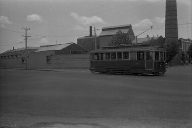
 Ballarat Tramway Museum
Negative, Wal Jack, between May and Oct. 1946
Yields information about the appearance of the Gardens area and car 16, late 1930's?Negative and Digital image of the Wal Jack Ballarat Negative file of tram No. 16 at Gardens Loop. Tram has the destination of Victoria St. Based on Wal Jack records for this car, it was painted in the SEC standard scheme without cream panels in May 1946 and numbers added Oct. 1946 - possibly soon after painting. See Reg Item 5526.trams, tramways, gardens loop, wendouree parade, tram 16 -
 Ballarat Tramway Museum
Negative, Wal Jack, late 1940's or early 1950's
Yields information about the tram services and the Ballarat A Power Station.Negative and Digital image of the Wal Jack Ballarat Negative file of No. 11 southbound in Ripon St passing Ballarat A power station.trams, tramways, ripon st, ballarat a power station, tram 27 -
 Kew Historical Society Inc
Plan, Melbourne & Metropolitan Board of Works : Borough of Kew : Detail Plan No.1563, 1905
The Melbourne and Metropolitan Board of Works (MMBW) plans were produced from the 1890s to the 1950s. They were crucial to the design and development of Melbourne's sewerage and drainage system. The plans, at a scale of 40 feet to 1 inch (1:480), provide a detailed historical record of Melbourne streetscapes and environmental features. Each plan covers one or two street blocks (roughly six streets), showing details of buildings, including garden layouts and ownership boundaries, and features such as laneways, drains, bridges, parks, municipal boundaries and other prominent landmarks as they existed at the time each plan was produced. (Source: State Library of Victoria)This plan forms part of a large group of MMBW plans and maps that was donated to the Society by the Mr Poulter, City Engineer of the City of Kew in 1989. Within this collection, thirty-five hand-coloured plans, backed with linen, are of statewide significance as they include annotations that provide details of construction materials used in buildings in the first decade of the 20th century as well as additional information about land ownership and usage. The copies in the Public Record Office Victoria and the State Library of Victoria are monochrome versions which do not denote building materials so that the maps in this collection are invaluable and unique tools for researchers and heritage consultants. A number of the plans are not held in the collection of the State Library of Victoria so they have the additional attribute of rarity.Original survey plan, issued by the MMBW to a contractor with responsibility for constructing sewers in the area identified on the plan within the Borough of Kew. The plan was at some stage hand-coloured, possibly by the contractor, but more likely by officers working in the Engineering Department of the Borough and later Town, then City of Kew. The hand-coloured sections of buildings on the plan were used to denote masonry or brick constructions (pink), weatherboard constructions (yellow), and public buildings (grey). This plan covers the area between Barkers Road, Wrixon Street, Sackville Street and Brougham Place, much of it now occupied by Carey Baptist Grammar and Preshil schools. This was an area of large and prestigious homes in 1903, some with formally laid-out gardens, such as ‘Tower Hill’ and ‘Opawa’. ‘Kalimna’ was built in 1890-91 for William H. Jarman, an accountant, and ‘Blackhall’ at the same time for W.H. Roberts. Blackhall was to be acquired by the Salvation Army in 1915 and renamed ‘Catherine Booth Girls’ Home’. The Home accommodated girls, aged between 4 and 16. Kalimna and Blackhall are of significance as typical and intact late Victorian mansions and as such are two key Victorian buildings to have been built in Kew. Both Blackhall and Kalimna are now part of Preshil. ‘Fairview’ was for a long time occupied by the Sisters of St. Joseph of Cluny as a care home for the elderly, but it is now part of Carey Grammar School, as are the grounds of ‘Wagga Merne’, ‘Weemutta’, ‘Blakely’, ‘Daheim’ and ‘Mildura’ (later ‘Urangeline’), the last being particularly impressive in 1903, with a tennis court, conservatory, outhouses, and two bathrooms!melbourne and metropolitan board of works, detail plans, mmbw 1563, cartography -
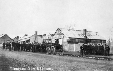 Eltham District Historical Society Inc
Negative - Photograph, Tom Prior, Election Day, Eltham, 4 June 1907
Election Day, Legislative Council Elections, Tuesday, 4 June 1907, Maria Street (Main Road), Eltham. Group of men standing outside George Knapman’s forge on Election Day (4 June 1907) for the Legislative Council. Voting was conducted in the Eltham Courthouse next door, to the right of photo. At that time women did not have the right to vote. At the far left can be see William B. Andrew’s Corn Store on the corner of Franklin Street. The weatherboard house in between at one stage the home of Miss George.This photo forms part of a collection of photographs gathered by the Shire of Eltham for their centenary project book,"Pioneers and Painters: 100 years of the Shire of Eltham" by Alan Marshall (1971). The collection of over 500 images is held in partnership between Eltham District Historical Society and Yarra Plenty Regional Library (Eltham Library) and is now formally known as the 'The Shire of Eltham Pioneers Photograph Collection.' It is significant in being the first community sourced collection representing the places and people of the Shire's first one hundred years. The Reynolds family were early settlers in Research. The Reynolds/ Prior collection of photographs were taken by Tom Prior, the maternal uncle of Ivy Reynolds, around 1900 and the 60 photos in the album give a fine overview of many of the landmarks of Research and Eltham over 100 years ago. lvy lived in the family home for many years at 106 Thompson Cres Research. Ivy's father, Ernst Richard Reynolds and grandfather, Richard Reynolds, lived at the same address. Ivy's father Richard worked for Mr. Trail on his property in Research. Reynolds Road is named after the family. Mr Tom Prior (wife Eva) worked at the Melbourne zoo. He was very innovative and made his own camera, using the black cloth hood to exclude the light. The photographs are a reminder of the rural nature of Research and Eltham and its rich heritage.Digital image 4 x 5 inch B&W Negelection day, elections, eltham, eltham courthouse, forge, george knapman, knapmans forge, main road, maria street, miss george, reynolds prior collection, shire of eltham pioneers photograph collection, w.b. andrew corn store -
Port Melbourne Historical & Preservation Society
Plan - North west elevation, Port Melbourne Town Hall, Engineering Department, City of Port Melbourne, 1915
Plan of new (1915) Town Hall, Port Melbourne (proposal ?). North west elevation, longitudinal section, front elevation, cross section A-A, section B-B.port melbourne town hall -
 Eltham District Historical Society Inc
Negative - Photograph, Construction work, Main Street Bridge, Greensborough, c.Dec. 1983
The original bridge over the Plenty River was replaced by a single lane bridge each way fed by two lanes each way on either side. As traffic grew a second bridge was added to complete the divided road across the riverFilm - Kodak CM 400 5079 7 strips, 26 framesinfrastructure, roads, bridge construction, greensborough, main street bridge, road construction -
Port Melbourne Historical & Preservation Society
Plan - Land sub-division at 34 Crockford Street, MMBW, Melbourne and Metropolitan Board of Works, Apr 1958
MMBW plan to sub-divide land at 34 Crockford St.built environment - commercial, percival edward mann, sue pentland, mmbw, melbourne and metropolitan board of works -
 Wodonga & District Historical Society Inc
Negative - Haeusler Glass Negatives Collection - Man and a dog standing on a verandah, c1910
The Wodonga Historical Society Haeusler Collection provides invaluable insight into life in late nineteenth and early twentieth century north east Victoria. The collection comprises manuscripts, personal artefacts used by the Haeusler family on their farm in Wodonga, and a set of glass negatives which offer a unique visual snapshot of the domestic and social lives of the Haeusler family and local Wodonga community. The Haeusler family migrated from Prussia (Germany) to South Australia in the 1840s and 1850s, before purchasing 100 acres of Crown Land made available under the Victorian Lands Act 1862 (also known as ‘Duffy’s Land Act’) in 1866 in what is now Wodonga West. The Haeusler family were one of several German families to migrate from South Australia to Wodonga in the 1860s. This digital image was produced from one of the glass negatives that form part of the collection, probably taken by Louis Haeusler (b.1887) with the photographic equipment in the Wodonga Historical Society Haeusler Collection.This item is unique and has well documented provenance and a known owner. It forms part of a significant and representative historical collection which reflects the local history of Wodonga. It contributes to our understanding of domestic and family life in early twentieth century Wodonga, as well as providing interpretative capacity for themes including local history and social history.Digital image created from the Haeusler Glass negative collection. A man a dog standing on a verandah. The house is made of brick with a roof of corrugated iron.wodonga pioneers, haeusler family, glass negatives, dry plate photography, wodonga families -
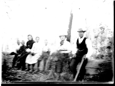 Wodonga & District Historical Society Inc
Negative - Haeusler Glass Negatives Collection - Group of people sitting on a log, c1910
The Wodonga Historical Society Haeusler Collection provides invaluable insight into life in late nineteenth and early twentieth century north east Victoria. The collection comprises manuscripts, personal artefacts used by the Haeusler family on their farm in Wodonga, and a set of glass negatives which offer a unique visual snapshot of the domestic and social lives of the Haeusler family and local Wodonga community. The Haeusler family migrated from Prussia (Germany) to South Australia in the 1840s and 1850s, before purchasing 100 acres of Crown Land made available under the Victorian Lands Act 1862 (also known as ‘Duffy’s Land Act’) in 1866 in what is now Wodonga West. The Haeusler family were one of several German families to migrate from South Australia to Wodonga in the 1860s. This digital image was produced from one of the glass negatives that form part of the collection, probably taken by Louis Haeusler (b.1887) with the photographic equipment in the Wodonga Historical Society Haeusler Collection. This item is unique and has well documented provenance and a known owner. It forms part of a significant and representative historical collection which reflects the local history of Wodonga. It contributes to our understanding of domestic and family life in early twentieth century Wodonga, as well as providing interpretative capacity for themes including local history and social history.Digital image created from the Haeusler Glass negative collection. A group of seven people sitting on a log, probably taken in Wodonga West, Victoria C. 1910. None of the people have been identified.wodonga pioneers, haeusler family, glass negatives, dry plate photography -
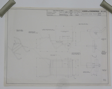 Federation University Historical Collection
Plan - Student's Technical Drawing, Engineering drawing 'Builder's Hand Truck', 1976
Pencil on paper student's technical drawing ballarat school of mines, technical drawing, darryl collins, engineering -
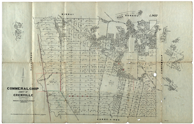 Federation University Historical Collection
Plan, Commeralghip, County of Grenville, 1905, 03/02/1905
The Township of Kaleno is in the Pitfield Plains. The Cape Clear Cemetery T contains the graves of miners and local pioneering families from the Cape Clear, Hollybush, Kaleno, Pitfield Plains, Pitfield, Illabarook, Berringa, Springdallah, Wallinduc, Glenfine, Happy Valley and Western Creek districts.Plan of allotments in Commeralghip, County of Grenville, Victoria. The plan includes the township of Kaleno, Dereel Pre-Emptice Right (John Cullen), Commeralghip Pre-Emptive Right (John Gordon McMillan and Glenfine Pre-Emptive Right (William Rowe). It also includes landholders such as Robert mcPherson, C. Cameron. John Boyd, John Cullen, W.T. Rowe, George Currie, J.P. Mackay, T. McCaffery, G. Hawkins, Alexander McPherson, C. Cameron. Gift of the Squire Family, 2014commeralghip, pitfield plains, kaleno, dereel, glenfine, squire, richard squire, w.t. rowe, john cullen, alexander mcpherson, george currie, mt misery, william rowe, mindai, john gordon mcmillan -
 Eltham District Historical Society Inc
Negative - Photograph, Open Day, Eltham Living and Learning Centre, 7 Nov 1987
Open Day, Eltham Living and Learning Centre, part of the Eltham Community Festival activites, 7 Nov. 1987eltham, eltham festival, eltham living and learning centre, living and learning centre, open day -
 Melbourne Tram Museum
Negative, Wal Jack collection, c1930
Black and white negative from Wal Jack collection of the W2 557, East Preston, route 9, Photo c1930. crossing "The Hump" over the Epping (Whittlesea) railway line alongside Preston Workshops. Photo may not be by Wal Jack as a size that he did not use.trams, tramways, w2 class, the hump, east preston, route 9, tram 557 -
 Eltham District Historical Society Inc
Negative - Photograph, Eltham Shire Council, Unidentified road, Eltham district, c.1985
One of a series of images on roll of film shot by Eltham Shire Council officers focussing on road and street infrastructure maintenance and upgrades and new rollover kerb and channel profilesRoll of 35mm colour negative film, 4 stripsKodak CP100 5094infrastructure, road construction, road drainage, road sealing, roadworks, shire of eltham, streets, streetscape -
 Federation University Historical Collection
Plan, Borough of Sebastopol, 1940, 01/07/1940
Sebastopol became a suburb of the City of Ballarat.Plan showing the streets, allotments creeks in the Borough of Sebastopol, Parishes of Ballaarat and Cardigan, County of Grenville, in 1940. sebastopol, t. rider, yarrowee creek, leigh river, st george's reserve, leigh creek, sebastopol public gardens, sebastopol recreation reserve, gravel reserve, night soil depot, sanitary depot, rubbish depot