-
 Bendigo Historical Society Inc.
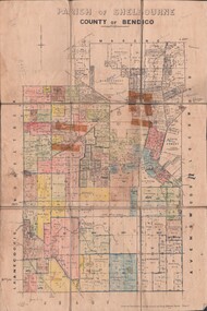
Map - JACK FLYNN COLLECTION: SHELBOURNE, 11/02/1937
Map: Parish of Shelbourne, County of Bendigo. Parish plan.By Authority, H. J.Green, Government Printer. Drawn and Reproduced at the Dept, of Lands and Survey, Melbourne, Victoria.map, bendigo, parish plan, shelbourne -
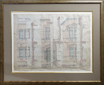
 University of Melbourne, Burnley Campus Archives
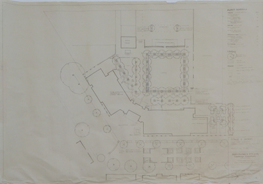
Plan - Plans, Alterations and refurbishment of the Centennial Display Building
-
Moorabbin Air Museum
Manual (Item) - P51-B Alighting Gear Analysis North American Aviation Inc
-
 Federation University Historical Collection
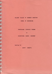
Manual - Manual - Readings, VIOSH: Manual of Readings for Professional Extension Program in Occupational Hazard Management
Manual of readings for various essay topics.Spiral bound manual - charts and graphsviosh, victorian institute of occupational safety and health, occupational hazard management, essay topic readings -
 B-24 Liberator Memorial Restoration Australia Inc
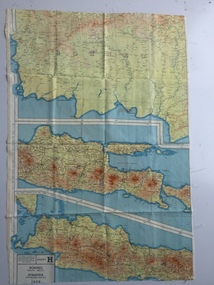
Map - British World War II silk map of Sumatra (South) and Java (Extreme North West), 1944
Silk and rayon maps were produced by Great Britain (some 1.75 million in total), the United States (c.7.5 million) and Australia during World War II. They were issued to Allied military personnel as part of 'escape and evasion' kits.This map, printed on rayon, is an original British 'escape and evasion' kit map from World War II.A multi-coloured, contoured, double-sided map printed on rayon, 1944 Series South West Pacific Area (SWPA) and Asia Sheet G Sumatra (South) and Java (Extreme North West) and, on the reverse, Sheet H Borneo (South West), Java and Sumatra (Extreme South)world war ii, silk maps, great britain, a187 -
Moorabbin Air Museum
Manual (item) - RAAF Mirage Aircraft - General & Technical Information, RAAF Escape Facility Mirage Aircraft Ejection Seat Type OM6 Specifications
-
Moorabbin Air Museum
Manual (Item) - Lycoming aircraft engine manuals, Lycoming Overhaul Manual O-320 and O-340 Aircraft Engines
Avco Lycomoin Division -
Moorabbin Air Museum
Manual (Item) - Aircraft guided weapons and Electronics supply division Mk 103B & 3B . 2nd Edition, Government Aircraft Factories Jindivik Schedule of spare parts
-
Port Melbourne Historical & Preservation Society
Map - Port Melbourne, Department of Lands and Survey, 20 Sep 1932
Dept. of Lands and Survey Map Sheet 5 Port Melbourne, Parish of South Melbourne.Annotated re MHT precincts on foreshore:Plan sketches re boat harbourtown planning, sandridge lagoon, melbourne harbor trust - port of melbourne authority, transport - railways -
Moorabbin Air Museum
Manual (item) - Hughes Helicopter Parts, Illustrated Parts Catalog Hughes Helicopters 500 Model 369HS /369HM/369HE
Hughes Helicopters Parts -
Moorabbin Air Museum
Manual (item) - Bristol Siddeley Civil Engines & Power Plants - Leaflets - Vol 1
-
Federation University Historical Collection
Plan, Alterations to the Ballarat School of Mines Electrical Engineering Department, 1947, 18/02/1947
Copy of a plan showing the Ballarat School of Mines Electrical Engineering Department, and wrought iron gates.ballarat school of mines, electrical engineering, buildings, architectural drawing -
Bendigo Historical Society Inc.
Map - KIMBOLTON, 24/05/1921
Maqp: Kimbolton, County of Bendigo. Parish plan ( number 175 in Map Cupboard 1)map, bendigo, parish plan, kimbolton -
Moorabbin Air Museum
Manual (Item) - Motorola Communications Australasia Syntrx FM Two-Way Radio 403-520MHz 25 Wattts Service Sheet
-
Moorabbin Air Museum
Manual (Item) - Bell Helicopter Structural Repair Manual For Bell Model 206 Series Helicopters
BHT-206-SRM-1 -
Moorabbin Air Museum
Plan (item) - Bristol Aeroplane 170 schematic drawings, Gusset Outer Wing
Bristol Aeroplane Company Ltd -
 Federation University Historical Collection
Plan - Plans, Ballarat School of Mines Brewery Building Plans, 1995, 1995
The Ballarat School of Mines Brewery Building is now a part of the Ballarat Technology Park.Site plan and landscape plan for Stage 3 works for the Ballarat School of Mines Brewery Building. .1) Site plan by Philip Cox Sanderson & Partners, Melbourne .2) Landscape plan by John Patrick Pty Ltd, Landscape consultants, Kew, Victoriaballarat school of mines, brewery building, ballarat technology park, john patrick, philip cox sanderson, landscaping, archtectural plans -
University of Melbourne, Burnley Campus Archives
Plan, David Reid, Dandenong College of T.A.F.E. Landscape Design, 1988
Student plans. (1) Master Plan by David Reid for Landscape Graphics 4, dated 17.10.1988. Scale 1:250. (2) Master Plan No 2 by L. Garnett October 1988. Scale 1:250. (3) Master Plan by Steve Soso for Landscape Graphics 4 dated 18.9.88. Scale 1:250.david reid, steve soso, landscape design -
 Federation University Historical Collection
Plan, Balllarat School of MInes New Classrooms, 1899, 1899
Architectural plan for the New Classrooms at the Ballarat School of Mines, later known as the Administration Building.ballarat school of mines, new classrooms, administration building, a building, architectural plans -
Moorabbin Air Museum
Manual (Item) - RAAF - Mirage III "D" Basic Servicing Schedule "D" Servicing Book 1 - Text , Volume 5, Part 3 ,Book 1, RAAF - Mirage III "D" Basic Servicing Schedule "D" Servicing Book 1 - Text
AAP 7213.002-2-5 -
Moorabbin Air Museum
Manual (Item) - Beechcraft Parts Catalog
Description: Model 60 (P-4 thru P-126 except P123) Model A60 (P-123, P-127-P-246) Model B60 (P-247 and after) Level of Importance: . -
Moorabbin Air Museum
Manual (item) - Plessey Advance Information I.P.N Starting System For Aero-Engines
-
Moorabbin Air Museum
Manual (Item) - Nondescructive Test Manual - Inspection Procedures for Boeing jet transports
-
Moorabbin Air Museum
Manual (Item) - Allison 501-D13 Engine And Aeroproducts Model A6441Fn-606 Propeller Training Notes
Description: 9 pages. Published by General Motors Corporation, Allison Division. Published with materials from 1955-1957. ALL 005 Level of Importance: World. United States -
Bendigo Historical Society Inc.
Map - SANDHURST SHEET 5, Circa 1940's
Map: Sandhurst sheet 5. Parish plan ( number 197 in Map Cupboard 1)map, bendigo, city streets, sandhurst -
Moorabbin Air Museum
Manual (Item) - Cessna 100 Series 1963 And On Service Manual
Description: Cessna Technical Parts Level of Importance: . -
Moorabbin Air Museum
Manual (Item) - Cessna - Model One Eighty . One Eight Five Skywagon Series And AG Carryall , 180 And 185 Parts Catalogue
-
Moorabbin Air Museum
Manual (item) - GAF Collection - Printed Board Dimensions And Tolerances IPC Standard ANSI/IPC-D - 300G
-
Moorabbin Air Museum
Manual (item) - ASTA Nomad N22 & N22B - Maintenance Manual Volume 2
-
Moorabbin Air Museum
Manual (Item) - King Navigation/Communications Unit Instruction Manual, Instruction Manual KX-160 Nav/Comm Unit