-
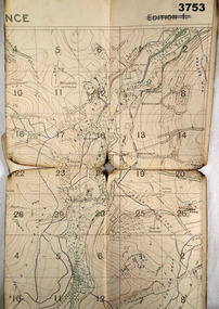
 Bendigo Military Museum
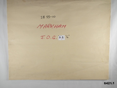
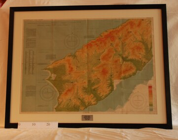
Map - SB55-10 Markham Joint Operations Graphics Air and Ground print separations, Royal Australian Survey Corps, Bendigo, Dec 1981
This set of map prints was assembled as a training aid. The collection is a complete set of individual color prints of each colour used on the final printed maps for each map Joint Operations Graphic (JOG) JOG Ground and JOG Air versions. This map series was produced in two versions to help coordinate military Ground Operations and Air Operations. The ground users required that heights and measurements were in Metres, whilst air users required height information in Feet for altimeters. The Air Version also contained more Aeronautical information including safe flying height information called Maximum Elevation Figures (MEF). Later printing of JOG incorporated printing in just four colours Cyan, Magenta, Yellow and Black (CMYK). Item 6421.1 is an example of a JOG Ground and item 6421.2 is an example of its matching JOG Air version.1:250,000 SB55-10 Markham JOG A and G colour separations bound together in a manilla card covered folder bound with a timber edge. royal australian survey corps, rasvy, fortuna, army survey regiment, army svy regt, asr -
 Bacchus Marsh & District Historical Society
Map, Lerderderg District Proposed Irrigation and Water Supply Trust (C). Plan showing overlap in boundaries of the Trust District
The 1886 Irrigation Act in Victoria introduced the first legislation in Australia designed to enable the creation of a detailed scheme for agricultural irrigation. Part of the legislation saw the use of government funds for local irrigation projects. These local projects were managed by local irrigation trusts. The Lerderderg Irrigation and Water Supply Trust was formed in 1890. Printed paper map of the proposed Lerderderg District Irrigation and Water Supply. Plan showing overlap in boundaries of Trust District referred to in Mr Burke's report. The Lerderderg District lies within the Parishes of Korkuperrumul and Merrimu in the County of Bourke. At the top of the map above its title is the letter 'C; in capital lettering. A note on this map states: 'Portion of Bacchus MarshUrban District included in area of proposed Trust District shown by hatched shaded lines thus /////////////irrigation, water supply, lerderderg irrigation and water supply trust -
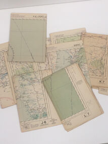 Nhill Aviation Heritage Centre
Map - Aeronautical Maps x 9, May 1943
Typical of the maps used during navigation training here at Nhill during WW2Aeronautical maps of Victoria, Printed on light card green text and markingsThird Edition May 1943, Sheet K8, Australian Aeronautical Map, Equatorial scale 1:1000,000map, aeronaughtical map, navigation -
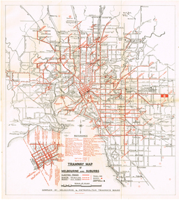
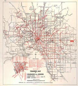 Melbourne Tram Museum
Map, "Tramway Map of Melbourne and Suburbs", c1950
Map of Melbourne's Tram and Bus routes, route destinations, all-night bus routes, depots, golf links and sporting grounds, rail lines, and location of major places of interest. Titled - "Tramway Map of Melbourne and Suburbs" - c1950, after the La Trobe or Latrobe St lines opened. Not known who produced the map. Does not give route numbers. See also Reg Item 2300 for an MMTB Map of the same era, 3720 for a similar version with the MMTB guest houses shown, and 4525.1 for an MMTB Photograph.Yields information about Melbourne tram routes prior to Bourke St being built.Fold out map (6 sections), two colours. Has been removed from a book with the remnants of other paper in the top left-hand side.has "1950" in top left hand corner in ink.trams, tramways, melbourne, map, tram & bus services, all night services, mmtb -
 Whitehorse Historical Society Inc.
Map, Aboriginal sites in the City of Doncaster-Templestowe, 1/03/1991 12:00:00 AM
Map of City of Doncaster and Templestowe.Map of City of Doncaster and Templestowe showing location of stone artefacts and scarred trees.Map of City of Doncaster and Templestowe. aborigines, city of doncaster and templestowe -
Stawell Historical Society Inc
Map, 1958
Parish of Stawell, Sheet 5stawell -
Stawell Historical Society Inc
Map, 1896
Plan of Works on No1 Reservoirstawell, water -
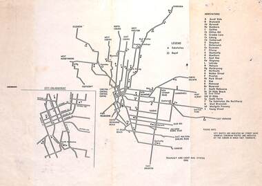 Melbourne Tram Museum
Map, "Tramway and Light Rail System - with substations", 1988
Map or Plan, titled "Tramway and Light Rail System", showing the routes as in 1988 with substations located and their abbreviation and name. Has an enlargement for the city area. Also locates depots and the location of the Carlton Centre control centre Not known who prepared the plan.trams, tramways, map, substation, depots, power supply, electrical engineering -
 Bendigo Military Museum
Map - TRENCH MAP WW1, 1918
Areas covered on this map, “Coisy, Allonville, Busy, Franvillers” Item re William Alexander No 502 AIF. Refer Cat No 3746.3 for his service details.Trench map, France, Edition 2A, sheet 62D N.W, scale 1:20,000, trenches corrected to 7.5.1918, British trenches in blue.On outside drawn in purple “62D N.W 1:20,000”map, france, trench -
Whitehorse Historical Society Inc.
Map, Council facilities, c1992
Map of City of Nunawading with parks and facilities marked and indexed.Map of City of Nunawading with parks and facilities marked and indexed.Map of City of Nunawading with parks and facilities marked and indexed.recreation facilities, city of nunawading, maternal and child health centres, senior citizens centres, parks and reserves, libraries, child care -
Port Melbourne Historical & Preservation Society
Financial record - PMHPS, Pat Grainger, Annual Report 2012, Aug 2012
PMH&PS was incorporated in 1994, and from 1995 was required to hold an AGM and present an Annual Report. These were compiled, designed, printed on photocopier and bound by the Secretary, except for the Tenth anniversary edition and most recent edition, commercially photocopied.Annual Report of the PMH&PS, 2012 A5 Pale grey with aerial photograph of Port Melbourne, including Lagoon. Contains financial reports, list of members and photossocieties clubs unions and other organisations, port melbourne historical & preservation society, pmhps -
Stawell Historical Society Inc
Map, Department of Lands and Survey, Borough of Stawell. Parishes of Stawell and Illawarra 1903, 1903
Victoria Co., St Georges Co., Wimerra Co., Leviathon Co. Tramway, Quarry reserve, Newington Co., Galatea Co., Moonlight Co., Federal Co., Borough reservior., A0 Map of Stawell on linen backing. Plus one Printed on PaperPhoto Lithograped at the Department of Lands and survey Melbourne by T.F. McGauran 13.6.03surevy -
Stawell Historical Society Inc
Map, Western Mining Corp / Stawell Joint Venture, Cross Section of Shafts. Long Section Newington - Three Jacks Looking West, August 1991
WMC/SJV Cross Section Western Mining Corporation Limited Stawell Joint Venturemining, gold, map -
Whitehorse Historical Society Inc.
Map, Blackburn East Primary School
Works Department detail survey.Public 1979. Rolled map. Works Department detail survey.Works Department detail survey.blackburn east primary school no. 4800, victoria. public works department -
 Federation University Historical Collection
Map, Sunbury, 1938
Printed colour map on papersunbury -
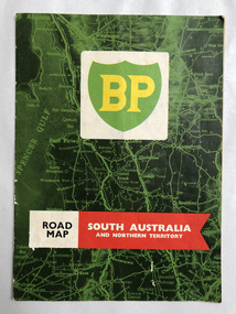 Robin Boyd Foundation
Map, South Australia and Northern Territory
p5 in blue pen Villa Sanso, 297 Kensington Rd. Swains, 209 Glen Ormond Rdwalsh st library -
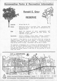 Whitehorse Historical Society Inc.
Map, Ronald E. Gray Reserve, n.d
Strategy of Committee of Management for development of reserve including planting of native trees and shrubs.parks and reserves, outlook drive, nunawading, springvale road, ashwood drive, olwen street, tatman, r. r, louden, j. b., gray, ronald e, r. e. gray reserve -
University of Melbourne, Burnley Campus Archives
Map, Photo Mapping Services Pty. Ltd, Burnley College Burnley Gardens, 1995
Map compiled by Photo Mapping Services Pty. Ltd., using aerial photography, dated 9th July, 1995. (1) Coloured proof. Scale 1:500. (2) aerial views, with and without trees marked, of Burnley Gardens. (2) Map with trees on paper. (3) Map without trees on paper, sections numbered, no legend.burnley college, gardens -
Whitehorse Historical Society Inc.
Map, Map of Nunawading, 1950?
Map of the entire City of Nunawading: complimentary map issued by Frank Fisher & Co real estate agents, Blackburn.Map of the entire City of Nunawading: complimentary map issued by Frank Fisher & Co real estate agents, Blackburn.Map of the entire City of Nunawading: complimentary map issued by Frank Fisher & Co real estate agents, Blackburn.nunawading, map -
 Montmorency/Eltham RSL Sub Branch
Map - Framed 1915 map of Sulva Bay, Gallipoli, 1915 Map of Silva Bay, Gallipoli, 1915
This map was used in the Dardenelles Campaign 1915-1916.Framed map showing the Sulva Bay area of the Gallipoli battlefield in 1915.world war one, middle east, gallipoli, 1915, map, dardenelles, sulva bay, survey department, battlefields, egypt cairo -
 Bendigo Historical Society Inc.
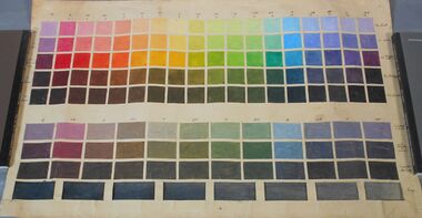
Education kit - Norman Penrose collection: colour palette and table
A colour palette used in art classes and a table describing the effects of combined two or three different hues. Used by Norman Penrose in his teaching carrier. Norman Penrose was born in Bendigo in 1903, studied at the Bendigo school of mines. He was a painter and teacher.art, teaching aid, colours -
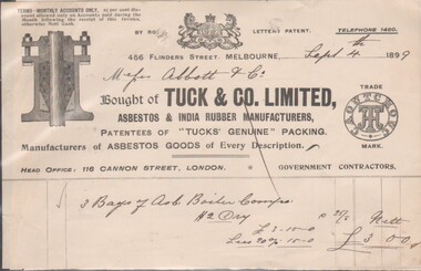 Bendigo Historical Society Inc.
Financial record - Five Bendigo Business Dockets, 1892 - 1902, 31/01/2017
Five Dockets related to operations and purchases by Bendigo Businesses8545a Docket from Tuck & Co. Limited, Asbestos & India Rubber Manufacturers, 4566 Collins Street, Melbourne; Sept. 4th, 1889; Head Office: 116 Cannon Street, London. Purchased 3 Bags of Asb. Boiler ?? at a cost of £3/- by Messrs. Abbitt & Co. 8545b Docket from G. Wood, General Founder, Kensington Iron Foundry, Macauley Road, dated Dec. 2nd, 1896; due from Mr. J. H. Abbott, For 1 doz. combination parts& 1/2 doz. stands for parts at £1/14/00. 8545c Memorandum James Oppy, Boot and Shoemaker, Fitzroy Street, Kerang, dated Aug. 23rd, 1893. Apology and advice the amount owing will be forwarded on 1st of next month (Sept.). 8545d Docket for six items purchased by Messrs. J.H. Abbott, Bendigo for £63/16/00 from The Australian Explosives & Chemical Coy. Ltd on Aug. 5, 1902. Manufacturers and Importers of High Explosives and Detonators, 356 Little Collins Street, Melbourne 8545e Docket / quote from J. Kennon & Sons, Tanners, Curriers & Leather Merchants, 206 Bridge Road, Richmond. October 19th, 1888, quotation sent to Mr. J H Abbott, Leather Merchant, Sandhurst.bendigo businesses, j. kennon and sons, tuck and co, g. wood, james oppy, the australian and chemical coy -
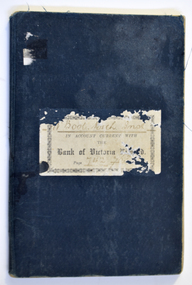 Warrnambool and District Historical Society Inc.
Financial record (Item) - Warrnambool Mechanics Institute & Free Library Bank of Victoria Bank Book, The Bank of Victoria Limited Warrnambool, 1904-1911
The Bank of Victoria was located at 7a Liebig Street, Warrnambool. The building still exists in 2023 as a part of the Quest apartments. The Warrnambool Mechanics' Institute was formed in 1859 and the first reading room opened in 1884. Responsibility for all activities of the Warrnambool Mechanics' Institute activities were formally handed over to the Warrnambool city Council on 27th July 1911. This Bank of Victoria Limited passbook documents credits and debits of the Warrnambool Mechanics' Institute & Free Library from December 1904 until 30th June 1911 just prior to the transfer to the Warrnambool City Council. This passbook is an example of how banking records were kept in the early 20th century. W'Bool. Mech. Inst. in Account with the Bank of Victoria Limited. Page 742 783warrnambool mechanics’ institute library, bank of victoria, warrnambool -
 Melbourne Tram Museum
Map, "Tramway Map of Melbourne and Suburbs", c1952
Map of Melbourne's Tram and Bus routes, route destinations, MMTB Guest houses, all-night bus routes, depots, golf links and sporting grounds, rail lines, and location of major places of interest. Titled - "Tramway Map of Melbourne and Suburbs" - c1952, after the La Trobe or Latrobe St lines opened. Not known who produced the map. Does not give route numbers. See also Reg Item 2300 for an MMTB Map of the same era, 7315 for a similar version but without the guest houses, and 4525.1 for an MMTB Photograph.Yields information about Melbourne tram routes prior to Bourke St being built.Fold out map (6 sections), two colours. Has been removed from a book with the remnants of other paper in the top left-hand side.trams, tramways, melbourne, map, tram & bus services, all night services, mmtb, guest houses -
Port Melbourne Historical & Preservation Society
Financial record - Invoice, Thirst Aid kiosk, Station Pier, Port Melbourne, 1950s
Various receipts and invoices from the Thirst Aid kiosk located on the western wing of Station Pier, 1953 to 1957 (Ref 1612)business and traders - kiosk, piers and wharves - station pier, melbourne harbor trust - port of melbourne authority, thirst aid kiosk, edward j (ted) rohan, kraft -
Stawell Historical Society Inc
Map, Township of Stawell Photo Map, 1947
Photograph of Stawell from Air Circa 1947. Shows mining sites and townshipmining, gold, map -
Glenelg Shire Council Cultural Collection
Financial record - Account - Professional Services, 01/11/1927
Account directed to Mr. Vivian Snr from Dr. D. W. Neville of Heywood, for professional services. Cost £1:1:0 -
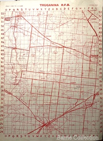 Melton City Libraries
Map, Truganina R.F.B, 1964
The Mount Cotterill Group encompassed the Rural Fire Brigades of Melton, Rockbank, Sydenham, Toolern Vale, Truganina, and Werribee and later Diggers RestMap belonging to the Truganina Fire Brigade emergency services -
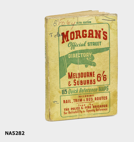 Whitehorse Historical Society Inc.
Map - Street directory, Morgans Official Street Directory
Morgan's street directories lack dates. Donor's parents, who lived in Blackburn, used this street directory .Small soft covered book of official street directory of Melbourne and suburbs.Morgans Official Street Directory Melbourne and Suburbs 6/6maps -
Glenelg Shire Council Cultural Collection
Financial record - Invoice - Campbell's Cash Stores, Aug-39
Invoice, dated 28 August 1939, from Kayser, to Campbell's Cash stores, Portland for silk hosiery