-
 Glenelg Shire Council Cultural Collection
Legal record - Probate - William Vivian, 12/07/1929
Probate of the Will of William Vivian. Standard Probate form, parchment, details typed in, signatures in black pen. Seal of the Supreme Court of Victoria, bottom left.Back: Purple Union Bank of Australia Ltd. stamp, dated 25 July 1929vivian family records, legal document, will, probate, william vivian -
Whitehorse Historical Society Inc.
Map, Nunawading, 1972
Variation of original 1864 map with a number of additions and bold marking of an area including Forest Hill, Vermont and Vermont South as 'Proclaimed survey area No 21 May 1972 2826. Marked as P M Noting Melb SeriesVariation of original 1864 map with a number of additions and bold marking of an area including Forest Hill, Vermont and Vermont South as 'Proclaimed survey area No 21 May 1972 2826. Marked as P M Noting Melb Series.Variation of original 1864 map with a number of additions and bold marking of an area including Forest Hill, Vermont and Vermont South as 'Proclaimed survey area No 21 May 1972 2826. Marked as P M Noting Melb Seriesmaps, shire of blackburn and mitcham, forest hill, vermont, vermont south -
Bendigo Historical Society Inc.
Map - TALAMBE, 26/11/1880
Map: Parish of Talambe, County of Bendigo. Parish plan (number 315 in map cupboard 1)map, bendigo, parish plan, talambe -
Ringwood and District Historical Society
Legal record - Conditions of Sale (C.E.Carter), Scoresby, Lot (?) on Plan of Subdivision (?), Mr S.A.H.Mullins and (?), Circa 1930
Particulars and Conditions of Sale of Property , from Mr S.A.H.Mullins. -
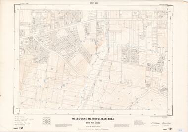 Ringwood and District Historical Society
Map - Melbourne Metropolitan Area Base Map Series, Sheet 255 - Ringwood area, 1963
Map prepared by Dept of Lands and Survey and MMBW from State Aerial Survey December 1956 and Cadastral Survey information May 1963. This sheet comprises parts of the Municipalities of Ferntree Gully, Nunawading and Ringwood, and Parishes of Nunawading, Ringwood and Scoresby.Scale: 400 feet to 1 inch. Contours at 5 feet vertical interval. By Authority: A.C. Brooks, Commonwealth Printer, Melbourne. -
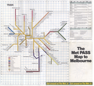 Melbourne Tram Museum
Map, The Met, "The Met PASS Map to Melbourne", c1988/90
Folded Map of Melbourne Rail and Tram lines, titled "The Met PASS Map to Melbourne" Tram Map - probably soon after conversion of the St Kilda and Port Melbourne lines to Light Rail, though these are not shown. Opened November 1987. Rail Map - shows Route 96 north section as Light Rail, co-ordinated bus routes, and the Altona line as going to Werribee. This route was opened in 1985. Date of Map c1988/1990. Has details of Museums, Art Galleries, Shopping, Gardens and Sports Arenas. See also Reg Item 379 for a similar item.trams, tramways, the met, melbourne, maps, tourist tickets -
Bendigo Historical Society Inc.
Map - SANDHURST (PART), No date Visible
Map: Hand Draughted parish plan showing the area North and East of Spring Gully Reservoir ( number 206 in Map Cupboard 1)map, bendigo, parish plan, parish of sandhurst, spring gully -
Bendigo Historical Society Inc.
Map - REDCASTLE AND DARGILE, No date visible
Map: Redcastle and Dargile. Parish planmap, parish plan, redcastle, dargile -
Bendigo Historical Society Inc.
Map - NEW CHUM LINE, 1875
Plan: Longtitudinal section of the Southern Section of the New Chum Line of Reef. Compilation consisting of small sections stapled togetherCALEB THOMAS 1875map, mining plan, gold mines, new chum line -
Stawell Historical Society Inc
Map, MPI Mines, Plan View of Township Area 2003, 13/6/2003
goldShowing known old gold workings Stawell Gold Mines. 13 June 2003 1 : 7500 MPI Minesmining -
Whitehorse Historical Society Inc.
Map, Aspinall's old abattoirs, Box Hill, 1937
Hand drawn plan of subdivision of old abattoirs site, Woodhouse Grove, Box Hill North.Hand drawn plan of subdivision of old abattoirs site, Woodhouse Grove, Box Hill North.Hand drawn plan of subdivision of old abattoirs site, Woodhouse Grove, Box Hill North.land subdivision, aspinall's estate, woodhouse grove, box hill north, aspinall road, box hill north, abattoirs -
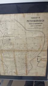 Peterborough History Group
Map - Map of the township of Peterborough, Township of Peterborough
Undated but indicative of the layout of the town. includes printed notes regarding the landscape and flora.Old map of the township of Peterborough from J S Irvine.A3 size paper map with tape around the sides. Includes handwritten notes.Handwritten on the rear is J.S Irvinepeterborough, old maps -
Bendigo Historical Society Inc.
Map - PARISH OF DIGGORRA, 23/02/1911
Map: Parish of Diggorra, County of Bendigo. Parish plan ( number 247 in Map Cupboard 1)map, bendigo, parish plan, diggorra -
Bendigo Historical Society Inc.
Map - HUNTLY, SHEET 4, 29/03/1876
Map: Parish of Huntly, Sheet 4, County of Bendigo. Hand Draughted Parish plan. Originally in Map Cupboard. Relocated to Map Drawer 5 on 22.9.22. Too long for the map cupboard.map, bendigo, parish plan, huntly -
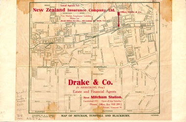 Whitehorse Historical Society Inc.
Map, Map of Mitcham, Tunstall and Blackburn, 1920 ?
Map of Mitcham, Tunstall and Blackburn.Map of Mitcham., Tunstall and Blackburn. Overprinted 'Drake & Co.' 1 copy 1927?, 1 copy 193-?Map of Mitcham, Tunstall and Blackburn.mitcham, tunstall, nunawading, blackburn, maps, drake & co., forest hill, vermont -
Bendigo Historical Society Inc.
Map - LEICHARDT, Circa 1870's
Map: Leichardt, Hand draughted parish plan ( number 300 in map cupboard 1 )map, bendigo, parish plan, leichardt -
Whitehorse Historical Society Inc.
Map, Blackburn Road, Blackburn, 1970
Enlarged aerial photograph of area around the intersection of Blackburn and Canterbury Roads, Blackburn.Enlarged aerial photograph of area around the intersection of Blackburn and Canterbury Roads, Blackburn.Enlarged aerial photograph of area around the intersection of Blackburn and Canterbury Roads, Blackburn.canterbury road, blackburn, blackburn road, blackburn, rosslyn street, blackburn south, masons road, blackburn, lavelle street, blackburn, vernon street, blackburn, wirreanda court, blackburn, aerial photographs -
Glenelg Shire Council Cultural Collection
Financial record - Cheque Book - Portland Free Library, 1945-1948
portland free library, finance, administration, glenelg shire council archives, cheque book -
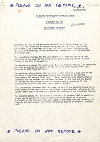 Whitehorse Historical Society Inc.
Legal record - Document, Melbourne Metropolitan Planning Scheme, 1987
Explanatory Statement of Amendment 500 to Melbourne Metropolitan Planning Scheme, including map of area (South of Blackburn Station). To be exhibited from 2 October 1987 to 22 December 1987.roads and streets, victoria. ministry for planning and environment, city of nunawading, south parade, blackburn, blackburn road, blackburn, main street, blackburn -
Clunes Museum
Financial record - RECEIPT BOOK, CLUNES LIBRARY 1960-64
BLUE CARDBOARD BLACK BINDING RECEIPT BOOK 1960-64library 1960-64, receipt book -
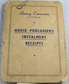 Wodonga & District Historical Society Inc
Financial record - Housing Commission Victoria House Purchaser's payment book, C. 1950's
The Housing Commission of Victoria (HCV) was established by the Victorian Government in 1938 after a public campaign for housing reform. After 1942 the HCV was responsible for developing regional and outer suburban housing estates where low-income families were located in proximity to expanding population areas and post-war industries. With greater funding and a severe housing shortage, the Commission's activities greatly expanded through the late 1940s into the 1950s. They began to build larger and larger estates of housing in the suburban fringes, as well as country towns The Housing Commission was largely responsible for the development of Wodonga up to 1973 and in 1975 was said to have built one-third of all homes in Wodonga, though many of these were handed to the Army. Criticism of the bureaucratic and undemocratic nature of the Commission and scandals over corruption in relation to housing developments in Melbourne's fringe areas resulted in the disbandment of the HCV and the formation of a Ministry of Housing in 1984. The work of the Housing Commission of Victoria allowed many people in Wodonga to acquire affordable housing and pay it off over time through monthly instalments. This booklet is of local and state significance as it is evidence of the role of the Victorian Government is providing access to affordable housing. It supported the development of Wodonga and the realisation of the "Australian dream" of home ownership.A small receipt book issued by the Housing Commission of Victoria to record payments and receipts for tenants who were purchasing their home through the Housing Commission. Monthly installments allowed people to access and purchase, affordable housing. On the front cover "Housing Commission/VICTORIA/ HOUSE PURCHASER'S/ INSTALMENT/RECEIPTS"housing wodonga, housing commission of victoria, public housing wodonga -
Bendigo Historical Society Inc.
Map - CAMPBELL COLLECTION: BENDIGO AND DISTRICT MAPS, March 1947
Map. Mandurang, County of Bendigo, Sandhurst, Strathfieldsaye, Sedgwick, Sutton Grange, Ravenswood, Lockwood. Scale 40 chains to 1 inch. Drawn and reproduced at the Department of Lands and Survey, Melbourne, March 1947, price 2/-. By Authority : J.J. Gourley, Government Printer, Melbourne. (number 402 in map cupboard 1)J.J. Gourley, Government Printer.map, bendigo, allotments -
Whitehorse Historical Society Inc.
Map, Schwerkolt Cottage Historical Building, 1973
Plans for the construction of the Historical Museum in the grounds of Schwerkolt Cottage by the City of Nunawading.Plans for the construction of the Historical Museum in the grounds of Schwerkolt Cottage by the City of Nunawading.Plans for the construction of the Historical Museum in the grounds of Schwerkolt Cottage by the City of Nunawading.schwerkolt cottage & museum complex, museum -
University of Melbourne, Burnley Campus Archives
Map - Photocopy, La Trobe University Bundoora Campus, 2000
2 photocopies and 1 enlarged photocopy of map reproduced from Melway Street Directory, Edition 29, of La Trobe University Bundoora Campus.la trobe university, bundoora campus -
Bendigo Historical Society Inc.
Map - MARONG : COUNTY OF BENDIGO, June 1953
Map. Marong, County of Bendigo, Nerring, Sandhurst, Lockwood, Shelbourne, Woodstock, Leichardt, Fletcher Creek, Bullock Creek, Township of Marong, Marong Railway Station, Bendigo Railway Line, Spring Creek, Crusoe Aqueduct. By authority W.M. Houston, Government Printer. Drawn and reproduced at the Department of Lands and Survey, Melbourne, Victoria. June 1953. Price 2/-. (number 73 in map cupboard 1)W.M. Houston, Government Printermap, bendigo, marong -
University of Melbourne, Burnley Campus Archives
Financial record - Register, Burnley Horticultural College, 22.02.1971-14.09.1977
transactions, finance, cash book -
Stawell Historical Society Inc
Map, Warra Warra, County of Borung, Shire of Stawell, 1957
Warra Warra, County of Borung, Shire of Stawellstawell -
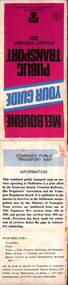 Melbourne Tram Museum
Map, Ministry of Transport, Melbourne Public Transport Map - No. 9, 1979
Map No. 9 - Includes description of tram and bus routes, private bus routes. Has contact details for bookings and lost property etc and how to use the map. Yields information about Melbourne public transport services in 1979Fold out map (27 sections 9 across x 3 deep), "Public Transport Map", coloured of Melbourne's Tram and Bus routes, route numbers, rail lines, detailed for the central part of Melbourne and the outer Metropolitan services.tramways, melbourne, tram services, bus services, railways, travelcard, maps -
Whitehorse Historical Society Inc.
Legal record - Correspondence, Application, 1977
A 1977 application for position of attendant at the Nunawading Historical Society Museum (now Schwerkolt Cottage & Museum Complex)A 1977 application for position of attendant at the Nunawading Historical Society Museum (now Schwerkolt Cottage & Museum Complex)A 1977 application for position of attendant at the Nunawading Historical Society Museum (now Schwerkolt Cottage & Museum Complex)bawden, frank, schwerkolt cottage & museum complex -
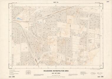 Ringwood and District Historical Society
Map - Melbourne Metropolitan Area Base Map Series, Sheet 236 - Ringwood area, 1961
Map prepared by Dept of Lands and Survey and MMBW from State Aerial Survey June 1957 and Cadastral Survey information May 1961. This sheet comprises parts of the Municipalities of Croydon and Ringwood, and Parishes of Ringwood and Warrandyte.Scale: 400 feet to 1 inch. Contours at 5 feet vertical interval. By Authority: A.C. Brooks, Commonwealth Printer, Melbourne.