-
 Melbourne Tram Museum
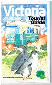
Map, Surveyor General for the Victorian Tourism Commission, "Victoria Australia Tourist Guide", 1985
Folded map of Victoria, showing in colour relief Victorian area, national parks, highways, towns, railways, airport, wine growing areas, towns with information centres, historic parks, ski fields. NSW and SA show major towns and highways. Front cover includes an image of a Z class tram and two penguins. Has town index. Folded 7 folds horizontally by 3 folds deep. On rear is a listing of locations with major tourist destinations provided. Provides location of VicTour offices. Prepared by the Surveyor General for the Victorian Tourism Commission, printed by the Government Printer, 4th edition 1985.trams, tramways, victoria, map, victour, tourism -
 Peterborough History Group
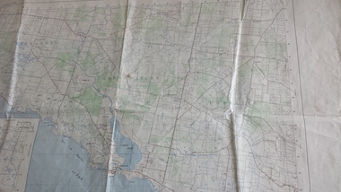
Map - Government map, Government Printer, Port campbell, 1957
Aerial survey map showing roads, vegetation and other landscape features.Significant because it shows the detail of the region in 1957Original 1957 State Aerial Survey Map of Port Campbell region, including Peterboroughpeterborough, aerial survey map, maps, port campell -
 Port Melbourne Historical & Preservation Society
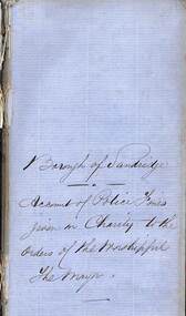
Financial record - Ledger, Police fines given to charity, Borough of Sandridge, 1860s
Used to record amounts received from Council police fines and distributed to the needy on Mayors' orders.Slim volume bound in ivory paper, hand titled on spine in ink either brown or faded to brown: 'Police fines given to Charity - Borough of Sandridge' - 1860s(damaged, wrapped)local government - borough of sandridge, charities and appeals -
 Ruyton Girls' School
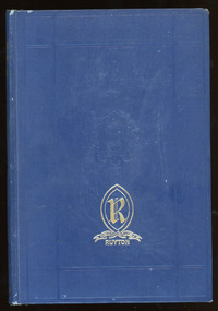
Literary work - Ruyton Prize Book, Geoffrey Cumberlege Oxford University Press, The Poetical Works of Matthew Arnold, No date
This book contains a collection of poems written by English poet and cultural critic, Matthew Arnold, with an introduction by Sir A. T. Quiller-Couch. Matthew Arnold was characterised as a sage writer, a type of writer who chastises and instructs the reader on contemporary social issues. He was also an inspector of schools for 35 years, and supported the concept of state-regulated secondary education. Ruyton Girls' School has a long tradition of awarding prizes to students at annual "Speech Night" events. Speech Night at Ruyton is an extraordinary occasion. It is a time when we gather to celebrate both the year just lived and the contribution of our Year 12 girls to the life of our School. It is a night of stirring student speeches, acknowledgement of student endeavour and excellence and awe-inspiring performances by School choirs and ensembles. The record has strong historic significance as it was awarded to a former notable student, Helen Gordon (maiden name Cole). Helen started at Little Ruyton in Prep 1940 and finished Year 12 in 1952 as School Captain, Bromby Captain, Form Captain for Matric, Tennis Captain, Hockey Captain, Swimming Vice Captain, and an award for Best All-Round Girl. She also played baseball for Victoria. After finishing school, Helen went on to graduate from the University of Melbourne as a physiotherapist in 1956. Her first position at age 19 involved setting up clinics with the Victorian Health Department Poliomyelitis Rural division. Helen’s strong ties to Ruyton continued when she held the position of President of the Old Ruytonians’ Association from the start of 1966 to the end of 1967. In 2019, Helen received an Order of Australia Medal for service to community health as a physiotherapist. She was also the recipient of the 2022 Victorian Senior Achiever Award at Parliament House. Helen passed away in July 2023 at age 88. The record's significance is further enhanced by its strong provenance, having been produced by Ruyton Girls' School and donated to the Archives by a familial connection.Navy leather hardcover bound book with gold detailing on front cover and spine. 494 pages.Front Cover: R / RECTE ET FIDE LITER / RUYTON / Spine: MATTHEW / ARNOLD'S / POEMS / OXFORD / Inside Cover: R / RECTE ET FIDE LITER / RUYTON / PRIZE / AWARDED TO / Helen Cole / FOR / Best all-round girl / Form Matriculation / H. Daniell. / December 11 1952 / Gift of the Old Ruytonians /ruyton girls' school, school, students, prize, speech night, poetry, lord tennyson, queen victoria, senior school, high school, ruyton, old ruytonians' association -
 Ringwood and District Historical Society
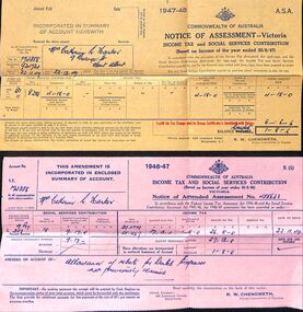
Financial record, Income tax assessments for Mrs.Catherine R. Harker (Ruby Wilson), Mont Albert, 1946-49
Ruby married Archie Harker. They lived laterly in Grange Street Mont Albert.6 various coloured papers tax assessments in a buff coloured envelpe from the Taxation Office Commonwealth of Australia. -
 Federation University Historical Collection
Map, City of Ballarat and Borough of Sebastopol Road Map
Road map of the City of Ballarat and the Borough of Sebastopol. WGS 85 Centroid 37 degrees 33 feet 56 inches south 143 degrees 51 feet 09 inches eat E-W- extent: 9 km N-S- extent: 11.5 kmballarat, sebastopol, map, plan, ballarat shire -
Whitehorse Historical Society Inc.
Map, Eastern Suburbs, 1922
Enlargement of sections of 1922 Ringwood Commonwealth Survey - Imperial General Staff (West - Camberwell; North - Templestowe; East - Ringwood; South - Clayton)maps, nunawading, tunstall, box hill, blackburn, mitcham, vermont, burwood east, mont albert -
 Bendigo Historical Society Inc.
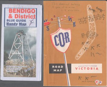
Map - Road maps
Two road maps. On, Bendigo & District blue guide handy map the other a road map of Victoria. On the back of the Bendigo map the date October 2000. On the Victoria map the words in pen "This doesn't belong to you, it is mine". L.J. Ellison and a blue stamp of Axedale service station. Aileen and John Ellison Collection.road map, victoria, bendigo -
Warrnambool and District Historical Society Inc.
Financial record - Dockets (two), John Hyland et al, 1897
These two 1897 dockets are from the Warrnambool auctioneers, John Hyland and Archibald Macfarlane. They refer to the sale by auction of the material from the demolition of the temporary buildings erected at the corner of Timor and Liebig Streets in Warrnambool as part of the staging of the Warrnambool Industrial and Art Exhibition, 1896-7. This exhibition, a major event in Warrnambool's history, ran from December 1896 to March 1897 and according to the press reports at the time attracted over 70,000 people to its many exhibitions, competitions and entertainments. Despite its popularity the Exhibition ran at a financial loss and the sale of the material from the temporary buildings was an attempt to recoup some of the losses. The sale of the timber, iron, glass etc from the temporary buildings returned about one-third of the original cost of the buildings. A feature of the John Hyland docket is the payment of seven shillings and sixpence to Ballis the bellman for ringing his bell and vocally advertising the sale in the town. These two dockets are of considerable interest as they add to our knowledge of the Warrnambool Industrial and Art Exhibition, an important event in our local 19th century history.1 and .2 These are two dockets printed on white paper with ruled red lines.The headings are printed and the details of sales are handwritten in black ink.19th century warrnambool auctioneers, warrnambool industrial and art exhibition 1896-7 -
 Melbourne Tram Museum
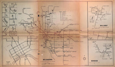
Map - Melbourne - Ballarat - Bendigo Tramways, 23-9-1969
Provides a detailed map of Melbourne, Ballarat and Bendigo tram lines - dated 23-9-1969. Shows street names, depot locations, depot layouts, track details including an insert for Sturt St Ballarat and destination locations. Provides a scale for each system. Not known who prepared the drawing.Yields information about the three operable Victorian systems at the date of preparation.Printed - dyeline? map on a folded sheet of papermap, melbourne, ballarat, bendigo, tramways, diagram -
 Lara RSL Sub Branch
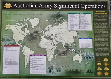
Map - Areas in Which Australian Soldiers Have Served - World War 1 and World War 2 and Other Theatres (2 Off), Australian Army Significant Operations Map. (2 Off)
This map shows the areas in which Australian soldiers have served.Map of World showing Australian Armed Forces Theatre of Operations (Map)Rectangular in shape with a glossy front. (2 Off)Australian Army Significant Operationsaustralian army significant operations -
Clunes Museum
Financial record - LEDGER, Day Book
Used in Theo Harden's Boot and Shoe Emporium, Fraser Street, ClunesLarge book with leather spine with "Day Book" label. Brown fabric cover.Day Book on labellocal history, books, day bookbusinesses of clunes -
Whitehorse Historical Society Inc.
Map, Bike Paths, 1995
Map in Boroondara Bulletin showing Bike paths in the City of Boroondara.Map in Boroondara Bulletin showing Bike paths in the City of Boroondara.Map in Boroondara Bulletin showing Bike paths in the City of Boroondara.bicycle paths, city of boroondara -
Whitehorse Historical Society Inc.
Map, City of Nunawading, n.d
Map of the City of Nunawading with a list and locations of 49 schools.Map of the City of Nunawading with a list and locations of 49 schools. Scale: 1 mile = 3.75 inchesMap of the City of Nunawading with a list and locations of 49 schools. schools, city of nunawading -
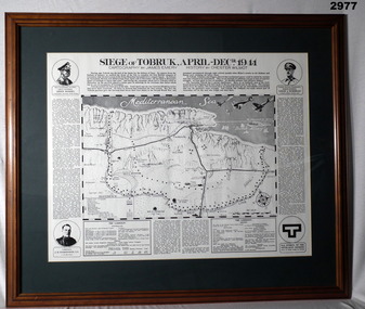 Bendigo Military Museum
Map - MAP, FRAMED TOBRUK, Post WW2
Wooden framed, glass fronted, green bordered, black & white map with history.“Siege of Tobruk April - Decr 1941 Cartography By James Emery History By Chester Wilmot”framed, maps, tobruk, passchendaele barracks trust -
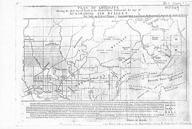 Whitehorse Historical Society Inc.
Map, Plan of locality, 1855-60?
'Plan of locality, showing the whole line of route to the district from Melbourne by way of Nunawading and Bulleen. 2,000 acres for sale... Thomas Ham, Land Agent [ 1855 - 60?]nunawading, bulleen, barkers track, land sales -
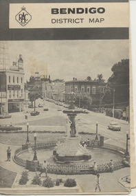 Ballarat Tramway Museum
Map, Royal Automobile Club of Victoria, "Bendigo District Map - RACV", c1971
Printed street map titled "Bendigo District Map", published by the RACV, showing the central part of Bendigo, Bendigo Outlets, streets, principal attractions, Bendigo and district maps and information, and a list of sporting and entertainment facilities. Has the tram lines shown dotted, only shows the full extent of the Golden Square line. The main map has the number "0171" in the bottom left hand corner, indicating the publication date.in ink on the Bendigo Outlet map, "3/4" along bottom edge.trams, tramways, map, bendigo, racv, railways -
 Kew Historical Society Inc
Financial record, Auburn Heights Recreation Club, Accounts Ledger, 1904-1908
Sports Clubs in Kew in the final decades of the 19th century and in the early 20th century were often umbrella organisations with facilities for a number of sports. Typically in Kew, this included teams in lawn bowls, tennis and croquet. The Kew Bowling Club was formed in 1880 while the privately owned Auburn Heights Recreation Club was opened in 1904. By 1998, the two Clubs decided to amalgamate at the Auburn Heights site in Barkers Road, forming the Kew Heights Sports Club. The combined club was itself taken over by the Melbourne Cricket Club in 2012 becoming MCC Kew Sports Club. In 2017 MCC Kew closed and its landholding was subsequently sold to Carey Baptist Grammar School. Both the Kew and Auburn Heights Clubs assembled important collections. These historically significant and large collections were donated to the Society in 2020. The collections include manuscripts, pictures, trophies, plans, honour boards etc. References Barnard FGA 1910, 'Sports and Pastimes' in Jubilee History of Kew Victoria: Its origin & progress 1803-1910. Chapman J & C 1999, The history of the Auburn Heights Recreation Club, 1904 to 1908. Reeve S 2012, City of Boroondara: Thematic Environmental History, p.216.The combined collections of the four sporting clubs making up the collection number hundreds of items that are historically significant locally. They are also significant to the sporting history of the greater Melbourne area and to the sports of lawn bowls and tennis in Australia in the 19th and 20th centuries. The collection illuminates two of the Victorian historic themes - 'Building community life' through forming community organisations and 'Shaping cultural and creative life' by participating in sport and recreation.The first bound Accounts Register of the Auburn Heights Recreation Club covering the period 1904 to 1908. [The item is part of the large historic Auburn Heights Recreation Club collection, including items relating to the sports of lawn bowls, tennis and croquet, gifted to the Kew Historical Society in 2020].clubs - lawn bowls - kew (vic), auburn heights recreation club - barkers road - kew (vic), auburn heights recreation club - minute books -
![Map - Maps, [John Batman in Melbourne], 1976](/media/collectors/4f729f5697f83e03086015b8/items/60965f673c71fad916b3a651/item-media/60965fc33c71fad916b3a805/item-fit-380x285.jpg) Greensborough Historical Society
Greensborough Historical SocietyMap - Maps, [John Batman in Melbourne], 1976
Photocopies of 4 maps showing aspects of John Batman's time in Melbourne: Map of the settlement of the Yarra 1837; Batman's map of Port Phillip and his route of exploration, 1835, drawn by Wedge; Proposed route of Batman's initial exploratiion, and Enlargement of the Geelong region of Batman's map. No citations on any copy.Photocopy of maps, 4 pages.john batman, melbourne, port phillip -
Stawell Historical Society Inc
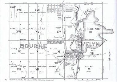
Map, Warngar, County of Kara Kara, Shire of Stawell, 1957
Warngar, County of Kara Kara, Shire of Stawellstawell -
Whitehorse Historical Society Inc.
Map, Station Street Mitcham
Map of business premises in Station Street Mitcham c. 1940s, drawn by Veronica Stodgell.Map of business premises in Station Street Mitcham c. 1940s, drawn by Veronica Stodgell. Photos of beauty salon manageress Joyce Phillips and Veronica StodgellMap of business premises in Station Street Mitcham c. 1940s, drawn by Veronica Stodgell. station street mitcham, no.9, phillips, joyce -
Whitehorse Historical Society Inc.
Map, City of Nunawading Historical Geography Project
Periods covered 1834-1879. Early colonists to coming of railway, 1880-1918 Land boom, bust to WW1, 1919-1944 Part WW1 to end of WW2, 1945-present Post war suburban explosion - farming, clay industries,settlement.local history, heritage awareness study steering commitee, johnston chris, walker, vanessa, vosper, maria, kellaway, carlotta -
Ringwood and District Historical Society
Literary work - Biography, The story of Mrs McCann, 69 Warrandyte Road Ringwood dated December 1973, Dec-73
Written by Mrs. E. McCann. House was "Castle Crag" home of the A.T. Miles family 1916.The story of Mrs McCann, 69 Warrandyte Road Ringwood dated December 1973, 25 pages, started 8-Jan-1967 +Additional Keywords: McCann, Mrs. E. -
Whitehorse Historical Society Inc.
Map, Blackburn East Primary School
Works Department detail survey.Public 1979. Rolled map. Works Department detail survey.Works Department detail survey.blackburn east primary school no. 4800, victoria. public works department -
 Greensborough Historical Society
Map, Dianne Edwards, Part of Parish of Yan Yean 1878, 1978
Map includes Crown Portions V - XVII, showing Yan Yean Reservoir, Melbourne-Whittlesea Railway route, names of landowners, roads and various other features west of Greensborough Road. Redrawn by A. R. Blair in 1978.1 p. black and white photocopy of mapyan yean reservoir, yan yean -
 The 5th/6th Battalion Royal Victoria Regiment Historical Collection
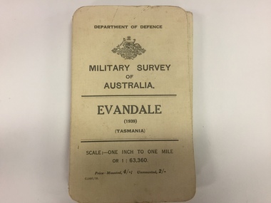
Map, Military Survey of Australia. Evandale (1939) (Tasmania), 1939
Fabric backed colour map, with card cover that folds into a small book. Scale one inch= one mile.military, survey, map, tasmania, ww2, wark vc club -
 Ringwood and District Historical Society
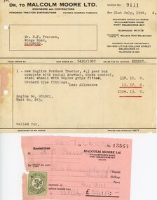
Financial record - Invoice and receipt, Sale of Fordson tractor, July, 1944
Invoice Dr to Malcolm Moore Ltd, Engineers and Contractors, to Mr H. F. Pearson, Wonga Road, Ringwood, Victoria. Receipt with Victorian duty stamp attached - July 1944 1 new English Fordson Tractor, 4.3 gear box complete with radial drawbar,choke control, steel wheels with Duplex grips fitted. Orchard type fittings. £338.10.0 Less Allowance £13.17.0. Total amount and receipt £324.13.0. -
 Ballarat Tramway Museum
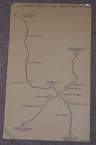
Map, "Bendigo Tramway Routes and Section Destinations", c1970
Demonstrates the layout of the Bendigo tramways, extracted from the Fare Schedule. Basis of production, source unknown. Associated with Eildon Hogan.Plastic coated, card mounted map showing diagrammatic routes of map of Bendigo routes, extracted from the SEC Fare Schedule.trams, tramways, bendigo, map -
Glenelg Shire Council Cultural Collection
Map - Map - Western Victoria / South Australia, n.d
Port of Portland Authority Archivesport of portland archives -
Stawell Historical Society Inc
Map, Stawell Gold Mine, Stawell Gold Mine Photo Map of Stawell Township showing Underground Declines in mining lease, 2007
SGM photo Map 2007 Produced for Public Consultation over Big Hill Open Pit Proposal. Aerial Views Stawellmining, gold, map