-
 Moorabbin Air Museum
Manual (Item) - HR Smith, Antenna outline data
-
Moorabbin Air Museum
Manual (Item) - NACA Report - Aeronautical studies 1947 to 1954, National Advisory Committee for Aeronautics Technical Notes 1429 to 3067
National Advisory Committee for Aeronautics -
Moorabbin Air Museum
Plan (item) - C.A.C Turbojet Trainer A.S. Viper XP.59 P269
-
 Moorabbin Air Museum
Manual (Item) - Pratt & Whitney Aircraft of Canada LTD. Illustrated Parts Catalog: PT6A-34, PT6A-34Ag, PT6A-36 and PT6A-135, Pratt & Whitney Illustrated Parts Catalog Manual Part No.3021244 for PT6A-34, PT6A-34Ag, PT6A-36 and PT6A-135
Pratt & Whitney manual producing during the 1970s/1980s covering the PT6A-34, PT6A-34Ag, PT6A-36 and PT6A-135 turboprop enginespratt & whitney, pratt and whitney engines, turboprop manual, pt6a-series engine -
Moorabbin Air Museum
Manual (Item) - Instrument Notes Mirage IIIO No 81 Wing RAAF
-
Moorabbin Air Museum
Manual (Item) - Maintenance Manual Vol.II Prop-Jet Engines Alison
-
Moorabbin Air Museum
Manual (Item) - Wildcat Martlet (IV) Handbook Of Instructions Structural Repair Model F4F-4B , F4F-4 & FM-1 Airplane
NAV AER 01-85 RC-3 A.P 2083 B -
Moorabbin Air Museum
Manual (Item) - RAAF Single Sideband Transmitting-Receiving System, Royal Australian Air Force SSP Equipment ASB-100 System
RAAF -
National Vietnam Veterans Museum (NVVM)
Manual, AIR publication (RAN) NA 01-855SAD-2-7
grumman tracker -
Moorabbin Air Museum
Manual (Item) - Project Nulka Training Documentation for DT/OTII Programme Electronic Warfare Decoy System Operation Course C31-Z00-002
-
Moorabbin Air Museum
Manual (Item) - (SP) Wolseley Hispano Aviation Engines Viper W4A Type
-
Canterbury History Group
Map - Milk delivery areas for Camberwell
Map showing the delivery areas for dairies in Camberwell.camberwell, canterbury, maps, dairies, youngs dairies, goddards dairy -
 Moorabbin Air Museum
Manual (Item) - (SP) AAP 7532.013-2M Altitude indicator system, Lear system
-
Moorabbin Air Museum
Manual (Item) - Woodward propeller type 2 synchro system
-
National Vietnam Veterans Museum (NVVM)
Journal, Routine orders
veterans – australia – periodicals, military history group inc. -
 Melbourne Tram Museum
Map, The Met, "Public Transport Map of Melbourne", June 1992
Map - 36 fold - 9 x 2 x 2- colour map of public transport including buses, titled "Public Transport Map of Melbourne", published by the Public Transport Corporation, Effective June 1992. Gives rail and tram maps, information on tickets. Has The Met contact details. 2 copies held .1 - as above but a 6 fold DL, dated Jan 8, 1995trams, tramways, map, ptc, melbourne, the met -
Moorabbin Air Museum
Manual (Item) - Lion Series 11B Aero Engine manual
-
 Falls Creek Historical Society
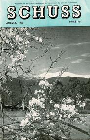
Journal - Schuss Vol. 21. No. 6 August 1955
Schuss was advertised as Victoria’s Official Ski Journal It was issued monthly from 1935 to 1961 except during the war when summer issues covered two months. This continued after the war, but it averaged 10 issues annually over its 25 year life. Schuss was published by the Ski Club of Victoria which had a membership of 38 Ski Clubs and demanded to be recognised as the prime authority on skiing in the state. The other 30 ski clubs with 85% of the members disagreed and the politics of skiing became heated. These clubs formed the Federation of Victorian Ski Clubs with their own journal, Ski Horizon. With the establishment of the Victorian Ski Association, Ski-Horizon published its last issue in Nov - Dec. 1955 and the role of the official journal was fully taken over by “Schuss”. This item is significant because it contains stories, images and information documenting the development of the ski industry in Victoria.The journal features stories and events chronicling developments in Victoria and internationally. Items related to the Falls Creek Area in this issue include:- Page 196 - A report on the Victorian Championships held at Falls Creek on 14 August 1955. Page 201 - SKYLINE Lodge of Falls Creek carried about eight feet of snow on its roof after the big August fall. As this consolidated more was added, till there was some 15 to 20 tons of packed snow on the roof. It also caused some damage which will require repairs in the spring; assistance from members is required in this work. This unusual depth of snow ensures skiing on the slopes above Skyline till well into the summer months. schuss journal, victorian championships 1955, skyline lodge -
Moorabbin Air Museum
Manual (Item) - Cessna - Operation Manual For Cessna 172 (Skyhawk)
Schutt Flying Academy Operations Manual Appendix 2 To Section 4 -
Whitehorse Historical Society Inc.
Map, Legislative Council - Electoral Provinces, 1991
State of Victoria. Legislative Council Electoral Provinces. Sheet 3 Metropolitan Map. 1990 - 1991 redivision.State of Victoria. Legislative Council Electoral Provinces. Sheet 3 Metropolitan Map. 1990 - 1991 redivision.State of Victoria. Legislative Council Electoral Provinces. Sheet 3 Metropolitan Map. 1990 - 1991 redivision.electoral boundaries, victoria. parliament. legislative council -
Whitehorse Historical Society Inc.
Map, Aerial photographs Nunawading, 1972
Department of Crown Lands and Survey, Melbourne, 1972.Department of Crown Lands and Survey, Melbourne, 1972. Project runs 34 - 39 - City of Nunawading. frames numbered from South to North boundaries, each strip numbered from West to east. The series extends further West to Box Hill and East to Ringwood than the 1970 project. No index map. Sheets 39/2 and 34/28 missing.non-fictionDepartment of Crown Lands and Survey, Melbourne, 1972.victoria. department of crown lands and survey, aerial photographs, nunawading, mitcham, blackburn, blackburn north, blackburn south, forest hill, vermont, burwood east, box hill, ringwood, vermont south -
National Vietnam Veterans Museum (NVVM)
Journal, Insite Magazine (Museums Australia, Victoria)
museums - australia - periodicals -
Moorabbin Air Museum
Manual - College of Civil Aviation Aircraft Maintenance Engineering Course Section No 5 Paper No 13
-
 Bendigo Historical Society Inc.
Map - BENDIGO HISTORICAL SOCIETY COLLECTION: EAGLEHAWK MINE MAP
Base map Australian map grid of Eaglehawk area. Map has letter attached from the Department of Conservation, Forests and Lands, 22 March, 1990, addressed to Felicity Kingerlie, BHS, requesting information regarding the historic mining sites marked on the map. Sites marked are: A. Golden Age Mine, engine mountings present B. Johnson's No. 2 Mine, engine mountings, old boiler foundations C. Johnson's No. 1 Mine, mullock retaining wall made from sandstone, engine mountings, remains of old building demolished? D. Toma's Eucalyptus Factory, old boiler still there, boiler shed, chimney (remnants of) outlet drain, distilling vats, dam, remnant of winch. E. New Argus Mine,mullock heap F. New Moon Mines Dams (1) stone walls G. North Lightning Hill Mine, engine mountings, quartz retainer wall, Pascoe and Simmons open cuts and other open cuts here too H. New Prince of Wales Mine and Poppet Head I. Quarry site for stone, excavation (for miners cottages in Clarke Street) J. Lancashire open cut mine K. Virginia Hill (cynaide vats etc) L. South Prince of Wales mine, now capped and fenced M (possibly ) Catherine United Mine, engine mountings, battery mountings?bendigo, mining, eaglehawk mines -
Kew Historical Society Inc
Plan - 30 Choice Home Sites in Kilby Road, Meldrum Street and Fairway Drive, 1965
Subdivision plans and real estate flyers/brochures reveal a number of aspects of urban development and history. The Kew Historical Society's collection of these plans, as well as advertisements extracted from magazines, cover key aspects of community development and architectural history of Kew and Kew Eat as well as surrounding suburbs. While most of the plans in the collection were gifted to the Society by the former City of Kew, a number of other plans and advertisements have been donated by individuals, of which this is an example.Original 4-page, bifold brochure, one of two in the collection, of home sites created following the creation of the Eastern Freeway which separated a section of land owned by the Kew Golf Club from the main course. The new estate featured 30 lots in Meldrum Street, Kilby Road and Fairway Drive.subdivisions -- kew east (vic.), subdivisions -- kew (vic.), kew golf club -
Whitehorse Historical Society Inc.
Map, Shire of Blackburn and Mitcham, 1938
Plan of Shire of Blackburn and Mitcham showing sections and lot numbers. Scale 8 chains to 1 inch.Plan of Shire of Blackburn and Mitcham showing sections and lot numbers. Scale 8 chains to 1 inch.Plan of Shire of Blackburn and Mitcham showing sections and lot numbers. Scale 8 chains to 1 inch.shire of blackburn and mitcham, blackburn, blackburn north, blackburn south, burwood east, forest hill, mitcham, nunawading, vermont, vermont south -
Moorabbin Air Museum
Manual - Pilot's Notes - DeHavilland Mosquito, Pilot's Notes for Mosquito Marks F11 and NFXII Merlin 21 or 23 Engines
Technical overview of controls, systems & operation for Mosquito pilots, circa 1943 & 1944 ( reprint )Manual in booklet form non-fictionTechnical overview of controls, systems & operation for Mosquito pilots, circa 1943 & 1944 ( reprint ) -
Moorabbin Air Museum
Manual (Item) - KDM 7000B Distance Measuring Equipment System Bendix/King General Avionics Division
Manual Number 006-00155-0003 -
Moorabbin Air Museum
Manual (item) - Boeing 767 Airliner Familiarisation Manual, 767 ANS General Familiarization (-1) Block No. VBO51
-
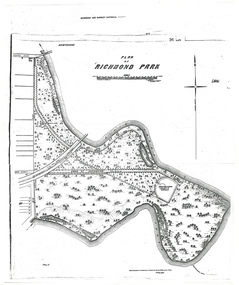 University of Melbourne, Burnley Campus Archives
Plan - Photocopy, A.L. Martin et al, Plan of Richmond Park, 1872
Layout of Richmond Park showing railway line, Pic-Nic Station, Swan Street extension and Horticultural Society's Garden. 3 photocopies of plan surveyed and drawn by A.L. Martin, Authorised Surveyor. Photolithographed at Dept of Lands and Survey by J. Noone 6th Sept. 1872. Showing the entire park and the Horticultural Society's Garden.richmond, parks, a.l. martin