-
 Moorabbin Air Museum
Plan (item) - Bristol Aeroplane 170 schematic drawings, Assy. of Skinning Wing End
Bristol Aeroplane Company Ltd -
Moorabbin Air Museum
Journal (item) - Assorted Aviation Magazines - see Notes
-
Port Melbourne Historical & Preservation Society
Plan - Annotated and handcoloured by Peter Libbis to indicate his research into Libbis family residences and hotels on copy of a section of an MMBW map, Melbourne and Metropolitan Board of Works, c. 1980s
Peter Libbis obtained these copies from the MMBW when he researched his family history in the 1980s. He has annotated them, colour in hotels etc. Donated to Society in 1997.One of a group of 19 photocopies of various 20th century MMBW plans, annotated/coloured in to indicate residences of Libbis family and local hotels, by Peter Libbis in family and hotel research - Harper's and lagoon, 1950s?hotels, built environment, melbourne & metropolitan board of works -
Kew Historical Society Inc
Journal, Kewriosity : June 1988
It rained - but the band played on [Rotunda - Alexandra Gardens, Kew Band, Australian Bicentennial] / p1. Dates for June / p2. Postage stamps, portraits and panoramas [Donald Cameron] / p2. Obituary [Mrs Gwen Gee, Kew Chess Club] / p2. Commentary / Cr Jim Tutt p3. YMCA to manage new Rec Centre [Kew Recreation Centre] / p3. Traffic - a perennial problem for Kew / p3. Did you know? [National Australia Bank] / p3. Notices / p4. Holiday time again / p4. Your rates at work / p4. Pre-school story time [Kew Library] / p4. Kew Living 1988 [Australian Bicentennial] / p4. Russian razzmatazz [Sadko Balalaika Orchestra] / p5. Metropolitan Fire Brigade visit to Council / p5. Council Review on Mother and Child Health / p5. Calling all cooks [Kew Community House] / p5. Kew Community House / Judy Price p6. What's on for young people in Kew? [Youth Resource Centre] / p6. Kew Community Action Group - 10 years on / p6. New community bus / p6. Walk your way to a fit active life [Boroondara Bushwalkers] / p7. Kew ballerina to perform in Russia [Miranda Coney] / p7. Dog warning / p7. Footy news [Kew Football Club] / p8. Keeping you informed [Citizens' Advice Bureau] / p8. Kew Emergency Flat [Kew Emergency House Steering Committee] / p8. Management Plan for Yarra Bend Park / p8.Kewriosity was a local newsletter combining Kew Council and community news. It was published between November 1983 and June 1994, replacing an earlier Kewriosity [broad] Sheet (1979-84). In producing Kewriosity, Council aimed to provide a range of interesting and informative articles covering its deliberations and decision making, together with items of general interest and importance to the Kew community and information not generally available through daily media outlets.non-fictionIt rained - but the band played on [Rotunda - Alexandra Gardens, Kew Band, Australian Bicentennial] / p1. Dates for June / p2. Postage stamps, portraits and panoramas [Donald Cameron] / p2. Obituary [Mrs Gwen Gee, Kew Chess Club] / p2. Commentary / Cr Jim Tutt p3. YMCA to manage new Rec Centre [Kew Recreation Centre] / p3. Traffic - a perennial problem for Kew / p3. Did you know? [National Australia Bank] / p3. Notices / p4. Holiday time again / p4. Your rates at work / p4. Pre-school story time [Kew Library] / p4. Kew Living 1988 [Australian Bicentennial] / p4. Russian razzmatazz [Sadko Balalaika Orchestra] / p5. Metropolitan Fire Brigade visit to Council / p5. Council Review on Mother and Child Health / p5. Calling all cooks [Kew Community House] / p5. Kew Community House / Judy Price p6. What's on for young people in Kew? [Youth Resource Centre] / p6. Kew Community Action Group - 10 years on / p6. New community bus / p6. Walk your way to a fit active life [Boroondara Bushwalkers] / p7. Kew ballerina to perform in Russia [Miranda Coney] / p7. Dog warning / p7. Footy news [Kew Football Club] / p8. Keeping you informed [Citizens' Advice Bureau] / p8. Kew Emergency Flat [Kew Emergency House Steering Committee] / p8. Management Plan for Yarra Bend Park / p8. publications -- city of kew (vic.), kewriosity, council newsletters, community newsletters -
Glenelg Shire Council Cultural Collection
Plan - Ship Plan / Mould, n.d
Wooden pattern for mould for boat fitting. Painted yellow/orange. ½ cylinder, small diam. handle either end. Wooden plugs to attach to other half of pattern. -
University of Melbourne, Burnley Campus Archives
Plan, Yarra 500/045.043 Municipalities of Prahran and Richmond, 1979
Melbourne and Metropolitan Board of Works Series 1:500. Map prepared by the Survey Division, MMBW January 1979. Scale 1:500.melbourne and metropolitan board of works, prahran, richmond -
 University of Melbourne, Burnley Campus Archives
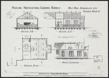
Plan, Pavilion, Horticultural Gardens, Burnley, 1916
1 large and 2 identical smaller photocopies. Pavilion, Horticultural Gardens, Burnley. Elevations and Ground Plan of "West Wing Remodelled into Science Room." Stamp GB 5173. Stamp date Dec 7th 1916. From Public Records Office.pavilion, burnley gardens, burnley school of horticulture -
Port Melbourne Historical & Preservation Society
Plan - Sandridge, Department of Lands and Survey, "The Township of Sandridge", 5 Nov 1860
Map of Sandridge, lithographed 1860, showing subdivisions on Evans Street, but no other development West of the railway Lihographed at the Department of lands and Survey, Melbourne 5th November 1860. Hand drawn annotations added at unknown date.Hand written "clay ground" 18 chains long, 7.5 chains broad, 26 chains from railwayengineering - roads streets lanes and footpaths, sandridge lagoon, transport - railways, town planning, local government - borough of sandridge -
University of Melbourne, Burnley Campus Archives
Plan (Item), Gibson North Island Bed 1:50 Nov. '17, 2017 - 2019
-
 Kew Historical Society Inc
Plan - Subdivision Plan, Myrtle Park Estate, City of Camberwell, 1916
The Kew Historical Society collection includes almost 100 subdivision plans pertaining to suburbs of the City of Melbourne. Most of these are of Kew, Kew East or Studley Park, although a smaller number are plans of Camberwell, Deepdene, Balwyn and Hawthorn. It is believed that the majority of the plans were gifted to the Society by persons connected with the real estate firm - J. R. Mathers and McMillan, 136 Cotham Road, Kew. The Plans in the collection are rarely in pristine form, being working plans on which the agent would write notes and record lots sold and the prices of these. The subdivision plans are historically significant examples of the growth of urban Melbourne from the beginning of the 20th Century up until the 1980s. A number of the plans are double-sided and often include a photograph on the reverse. A number of the latter are by noted photographers such as J.E. Barnes.The ‘Myrtle Park Estate’ was a subdivision bounded by Victoria Road (now Lansdowne Street), Buchanan Avenue and Dight Avenue. Other streets that were created by the subdivision included Eurolie Street, Boorahman Street and Moody Street (now Sylvan Street). The Estate took its name from Myrtle Park (later changed to Macleay Park), which had been created in 1923 by Camberwell Council. The Park adjoined the southeast corner of the new subdivision. The Estate included 74 regular allotments characterised by narrow frontages and long blocks. Confusion may have greeted prospective purchasers as the Estate was advertised in the daily newspapers as being in East Kew, rather than in Camberwell, where it was at that stage located.subdivision plans - balwyn, myrtle park estate - camberwell [surrey hills] -
University of Melbourne, Burnley Campus Archives
Plan, Fooks Martin Sandow Pty. Ltd, V.C.A.H. Burnley Proposed Brick Paving Layout & Detail, c. 1970
Coloured plan by Fooks Martin Sandow Pty. Ltd.fooks martin sandow -
 Kew Historical Society Inc
Plan - Subdivision Plan, Violet Farm Estate, 1927
Pru Sanderson, in her groundbreaking ‘City of Kew Urban Conservation Study : Volume 2 - Development History’ (1988), summarised the periods of urban development and subdivisions of land in Kew. The periods that she identified included 1845-1880, 1880-1893, 1893-1921, 1921-1933, 1933-1943, and Post-War Development. These periods were selected as they represented periods of rapid growth or decline in urban development. An obvious starting point for Sanderson’s groupings involved population growth and the associated economic cycles. These cycles also highlighted urban expansion onto land that was predominantly rural, although in other cases it represented the decline and breakup of large estates. A number of the plans in the Kew Historical Society’s collection can also be found in other collections, such as those of the State Library of Victoria and the Boroondara Library Service. A number are however unique to the collection.The Kew Historical Society collection includes almost 100 subdivision plans pertaining to suburbs of the City of Melbourne. Most of these are of Kew, Kew East or Studley Park, although a smaller number are plans of Camberwell, Deepdene, Balwyn and Hawthorn. It is believed that the majority of the plans were gifted to the Society by persons connected with the real estate firm - J. R. Mathers and McMillan, 136 Cotham Road, Kew. The Plans in the collection are rarely in pristine form, being working plans on which the agent would write notes and record lots sold and the prices of these.The subdivision plans are historically significant examples of the growth of urban Melbourne from the beginning of the 20th Century up until the 1980s. A number of the plans are double-sided and often include a photograph on the reverse. A subdivision plan for nineteen ‘bonny, airy building blocks’ on either side of Violet Grove, Kew East. Violet Grove runs between High Street and Harp Road. Like many other subdivisions in Kew and East Kew, older houses (Lots 1 and 13) were often included in the subdivision. Such houses were in some instances the original properties that were subdivided, or in the case of the Violet Grove subdivision, new houses such as the weatherboard villa on lot 13. This villa is advertised as having a tiled roof, 5 rooms, panelled hall, double doors (Rooms 14 x 12 ft. 6 in. (2) 14 x 12, 12 x 11, 13 x 11). A bricked front verandah, a tiled stove recess and existing sewerage connection added to its saleable potential. Water, electric light and power, and gas were all offered as part of the deal. Violet Grove now has about 35 houses, which indicates that the 19 lots of the subdivision were to be further subdivided by purchasers. [A similar plan is in the Batten & Percy Collection of the State Library of Victoria.]subdivision plans - east kew, violet farm estate, violet grove -- kew (vic.), boorool road -- kew (vic.), harp road -- kew east (vic.) -
 Kew Historical Society Inc
Plan - Subdivision Plan, Thornton Estate, 1918
The ‘Thornton Estate’ was the final subdivision of ‘Thornton’ in Studley Park Road. Thomas Cubitt Balmain originally owned Thornton, next to John Carson’s ‘Clutha’. Before its final subdivision, the Thomson family owned it. The Estate was a subdivision of 15 residential allotments running between Studley Park Road and Stevenson Street. The allotments faced these streets as well as Thornton Street, which the vendor undertook to make. Contemporary newspaper advertisements advised that ‘The estate possesses many advantages, notably its private and secluded, though convenient, position, splendid frontages and depths, and being close to the electric tram and Kew train, also within easy walking distance of the Victoria-street cable tram’. The terms offered purchasers were ten per cent deposit, with the balance to be paid in ten equal half-yearly payments at a rate of 5 per cent.The ‘Thornton Estate’ was the final subdivision of ‘Thornton’ in Studley Park Road. Thomas Cubitt Balmain originally owned Thornton, next to John Carson’s ‘Clutha’. Before its final subdivision, the Thomson family owned it. The Estate was a subdivision of 15 residential allotments running between Studley Park Road and Stevenson Street. The allotments faced these streets as well as Thornton Street, which the vendor undertook to make. Contemporary newspaper advertisements advised that ‘The estate possesses many advantages, notably its private and secluded, though convenient, position, splendid frontages and depths, and being close to the electric tram and Kew train, also within easy walking distance of the Victoria-street cable tram’. The terms offered purchasers were ten per cent deposit, with the balance to be paid in ten equal half-yearly payments at a rate of 5 per cent.subdivision plans - kew, thornton estate, studley park road -- kew (vic.), thornton avenue -- kew (vic.), stevenson street -- kew (vic.) -
 Melbourne Legacy
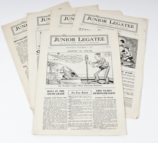
Journal - Document, set of newsletters, The Junior Legatee, Seven Issues from Wednesday, September 1, 1937 to Wednesday November 24, 1937
A newsletter produced on a regular basis by Melbourne Legacy for Junior Legatees, containing news, stories and messages including articles by current and retired members of the committee and executive as well as contributions from Legatee’s themselves. Articles include ‘Home Exercises for Girls’ Letters to the Editor and advice from the Legatee Doctor about sunburn and other health issues. It includes details of education classes, events, functions, holidays and news from the residences.Records the work done by Melbourne Legacy to care for children of servicemen who were either dead or no longer able to care for families. Also records social conditions of the times. Newspaper style newsletter of the Junior Legatee of between four and six pages. 00009.1, Vol 1, No 1, September 1, 1937 00009.2, Vol 1, No 2, September 15, 1937 00009.3, Vol 1, No 3, September 29, 1937 00009.4, Vol 1, No 4, October 13, 1937 00009.5, Vol 1, No 5, October 27, 1937 00009.6, Vol 1, No 6, November 24, 1937 00009.7, Vol 1, No 7, December 22, 1937. Became Legacy Newsletter in August 1942newsletter, activities -
 Kew Historical Society Inc
Plan - Subdivision Plan, Altyre Estate, 1920
Pru Sanderson, in her groundbreaking ‘City of Kew Urban Conservation Study : Volume 2 - Development History’ (1988), summarised the periods of urban development and subdivisions of land in Kew. The periods that she identified included 1845-1880, 1880-1893, 1893-1921, 1921-1933, 1933-1943, and Post-War Development. These periods were selected as they represented periods of rapid growth or decline in urban development. An obvious starting point for Sanderson’s groupings involved population growth and the associated economic cycles. These cycles also highlighted urban expansion onto land that was predominantly rural, although in other cases it represented the decline and breakup of large estates. A number of the plans in the Kew Historical Society’s collection can also be found in other collections, such as those of the State Library of Victoria and the Boroondara Library Service. A number are however unique to the collection.The Kew Historical Society collection includes almost 100 subdivision plans pertaining to suburbs of the City of Melbourne. Most of these are of Kew, Kew East or Studley Park, although a smaller number are plans of Camberwell, Deepdene, Balwyn and Hawthorn. It is believed that the majority of the plans were gifted to the Society by persons connected with the real estate firm - J. R. Mathers and McMillan, 136 Cotham Road, Kew. The Plans in the collection are rarely in pristine form, being working plans on which the agent would write notes and record lots sold and the prices of these. The subdivision plans are historically significant examples of the growth of urban Melbourne from the beginning of the 20th Century up until the 1980s. A number of the plans are double-sided and often include a photograph on the reverse. A number of the latter are by noted photographers such as J.E. Barnes.The Altyre Estate was advertised for sale by auction in 1920. A colour lithograph in the State Library of Victoria, in contrast to this monochrome version, notes the proximity of the subdivision to the Auburn Heights Bowling Club and to a range of transport options. The subdivision included fifty-one allotments as well as the original house ‘Altyre’ in Barkers Road. This version includes the amounts paid as deposit on a number of lots.subdivision plans - kew, altyre estate – kew (vic), barkers road – kew (vic), walsh street – kew (vic), ross street – kew (vic), loxton street – kew (vic), mount street – kew (vic), auburn heights bowling club, altyre -
Moorabbin Air Museum
Journal (Item) - Life in the RAAF during WW2, TAS journal
-
University of Melbourne, Burnley Campus Archives
Plan, Alexander Metherell Pty. Ltd, Report on Existing Site Conditions at Victorian College of Agriculture and Horticulture Burnley, 1983
Report in plastic folder by Alexander Metherell Pty. Ltd., Melbourne dated November, 1983. Includes plans of Orchard and Campus. See B11.0716 and B11.0599 for descriptions of plans.alexander metherell, vcah, burnley -
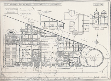 Mission to Seafarers Victoria
Plan - Architectural drawings, Walter Butler, New Missions to Seamen Institute Buildings Melbourne, 1916
In August 1916, Walter R. Butler presented the plans for the future central Seamen's Institute.The drawings show the original plans with rooms' names and intended use. They also show the original concept for the chapel which was in the Spanish Mission style.Plan copied from the 1983 Howden and Wardrop A4 report. A large plan on tracing paper (original or copy of the original) is held in the MSTV archives.flinders street, mission to seamen, mission to seafarers, walter richmond butler (1864–1949), norla dome, st peter chapel, spanish mission, arts and crafts, 1916 -
Moorabbin Air Museum
Journal (Item) - Panorama The Journal of Ansett Airline of Australia Vol 14. No.11 November 1972
-
 Ringwood and District Historical Society
Journal - Documents, Ringwood Croquet Club, Minutes of the Ringwood Croquet Club Committee meetings and Annual General meetings 1955-1960
The records of the Ringwood Croquet Club given to Gail Abbe - Archivist for safe - keeping with the request that they may be borrowed should the club require them for reference - 10-Dec-1993.Minutes of the Ringwood Croquet Club Committee meetings and Annual General meetings 1955-1960 -
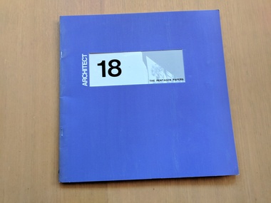 Robin Boyd Foundation
Journal, Neil Clerehan, Architect: Issue 18, 1972
Soft Cover Magazinearchitecture, australian architecture, walsh st library -
University of Melbourne, Burnley Campus Archives
Plan, Bodalla Aged Care Facility, 2001
Tracing paper copy, Proposed Landscape Drawing 1/1 dated 10.9.2001. Paper Drawing 2/3, dated 30.8.2001. Construction detail sketch with note attached to Jill.landscape design, bodalla aged care facility, kew -
Glen Eira Historical Society
Plan - Centre Road, 734, Bentleigh East
A one page typed letter, dated 30/09/1970 addressed to S P Simmonds Estate Agency from William Lasica and Co Solicitors requesting a valuation of the property at 734 Centre Road, Bentleigh East. The file also includes four pages of handwritten, undated and unattributed working notes with property description, calculations and a rough plan (96mm x 94mm) of the ground floor of the building for the valuation. Also included in the file is a two page duplicate copy of a typed letter, dated 08/10/1970 from W V Scott to William and Lasica Co Solicitors containing the valuation of the relevant property and rental details. The file also includes a one page photocopy of a handwritten document dated 15/11/1967. It gives details of a previous mortgage. The file also includes a photocopy, dated 26/09/1970, of the Certificate of Title of Lot 6 of Subdivision No 60044 Parish of Moorabbin. It includes a plan of the property (139mm x 123mm).klauss anna sara, klauss edward, green william james, green margaret estelle, green william thomas, myers thomas lee, lombard joseph patrick, graham george kinnell, tobin thomas norman, mcintosh edward joseph, bentleigh east, east bentleigh, centre road, bentleigh station, omeo court, east boundary road, s p l constructions pty ltd, r k c nominees pty ltd, maryland street caulfield investors, flats, land values, land titles, rents, renting, \ -
National Vietnam Veterans Museum (NVVM)
Journal, Odd Spot
veterans – australia - periodicals -
Kew Historical Society Inc
Journal, Kewriosity : February 1985
Happy New Year / p1. Community Notices [Religious notices; Clubs] / p2. Counselling needs in Kew / p2&8. Update: News from Council - Kew Council: 125 years on / Cr Robin Saunders [Mayor of Kew] / p3. Go ahead for Rec. Centre / p4. Traffic Management / p4&5. Haven for cricketers [J.D. Ryan Pavilion, Hays Paddock] / p4. Bowen Street closure / p4. Respite care [Hamer Court] / p5. Places filling fast [Davis Street Kindergarten] / p5. Kew Community House - 1985, here we come! [New Co-ordinator, Jo Osborne] / p5. Youth Pages - 1985 is yours! [Youth Resources Programme 1985] / p6&7. Wanted - people under 25 for I.Y.Y [International Youth Year] / p7. Kew Festival [Fun Day] / p7. This Kewriosity is being brought to you by - Kew Toy Library / p8. Letters / W. Stent, Resident of Kew for 65 years / p8. Carols a success / p8.Kewriosity was a local newsletter combining Kew Council and community news. It was published between November 1983 and June 1994, replacing an earlier Kewriosity [broad] Sheet (1979-84). In producing Kewriosity, Council aimed to provide a range of interesting and informative articles covering its deliberations and decision making, together with items of general interest and importance to the Kew community and information not generally available through daily media outlets.non-fictionHappy New Year / p1. Community Notices [Religious notices; Clubs] / p2. Counselling needs in Kew / p2&8. Update: News from Council - Kew Council: 125 years on / Cr Robin Saunders [Mayor of Kew] / p3. Go ahead for Rec. Centre / p4. Traffic Management / p4&5. Haven for cricketers [J.D. Ryan Pavilion, Hays Paddock] / p4. Bowen Street closure / p4. Respite care [Hamer Court] / p5. Places filling fast [Davis Street Kindergarten] / p5. Kew Community House - 1985, here we come! [New Co-ordinator, Jo Osborne] / p5. Youth Pages - 1985 is yours! [Youth Resources Programme 1985] / p6&7. Wanted - people under 25 for I.Y.Y [International Youth Year] / p7. Kew Festival [Fun Day] / p7. This Kewriosity is being brought to you by - Kew Toy Library / p8. Letters / W. Stent, Resident of Kew for 65 years / p8. Carols a success / p8. publications -- city of kew (vic.), kewriosity, council newsletters, community newsletters -
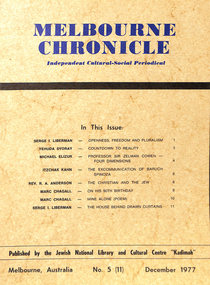 Kadimah Jewish Cultural Centre and National Library
Journal, Kadimah Jewish Cultural Centre and National Library, Melbourner Bleter / Melbourne Chronicle December 1977, ADD DATE
Journal published by the Kadimah Jewish Cultural Centre and National Library, Melbourne. Contains essays, reviews, fiction and poetry in both English and Yiddish.52 pages, A4, Softbound, Paper covers. non-fictionJournal published by the Kadimah Jewish Cultural Centre and National Library, Melbourne. Contains essays, reviews, fiction and poetry in both English and Yiddish.serge i. liberman, yehuda svoray, michael elizur, itzchak kahn, rev. r.a. anderson, marc chagall -
Glenelg Shire Council Cultural Collection
Plan - Plans / Line Drawings - Port of Portland Authority Slipway Bilge Blocks, Wooden Vessel, victoria, 12/10/1982
PORT OF PORTLAND AUTHORITYFront: '8' - black texta, top right corner -
National Vietnam Veterans Museum (NVVM)
Journal, Vietnam Veterans Motorcycle Club publications
vietnam veterans motorcycle club -
National Vietnam Veterans Museum (NVVM)
Journal, The Bulletin, March 4, 1967
vietnam war, 1961-1975 - participation, australian -
 Federation University Historical Collection
Plan, Madame Bent Gold Mining Company, not dated
A large plane showing a longitudinal section of the mine.madame bent gold mining company, mining