-
 Melbourne Tram Museum
Photograph - Colour print - B class tram - La Trobe St bridge, c2000
Colour print showing a B class tram (Bundoora RMIT) reversing at the western end of the then new LaTrobe St bridge. This section of track was opened during March 2000 - see Reference.Yields information about the LaTrobe St bridge.Colour print on paper - Kodak Professional Papertrams, tramways, bundoora rmit, latrobe street, docklands melbourne, route 86, b class -
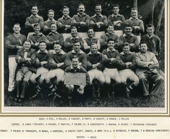 Ringwood and District Historical Society
Photograph, East Ringwood Football Club (ERFC) 1956 Seconds ERFC (Premiers)
Originally framed and shown up the stairs at the former Maroondah Sporting Club, the home of the East Ringwood Football Club -
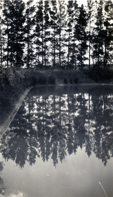 Whitehorse Historical Society Inc.
Photograph, Jones Flower Farm, 1928
Jones Family Collection - NP2565 to NP2606. See also ND3831.Black and white photograph of reflections in the dam on Jones' Flower Farm in Mt Pleasant Road, Nunawading, in 1928.jones, bette, walter, rolf, geoffrey, arthur, keith, lionel, muriel, jones flower farm, mount pleasant road nunawading -
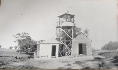 Tatura Irrigation & Wartime Camps Museum
Photograph, South Guard Observation Tower Dhurringile, 1940
Dhurringile guard duty.Black and white photograph of south guard observation tower with a shed either side.dhurringile pow camp, observation towers -
 Lakes Entrance Regional Historical Society (operating as Lakes Entrance History Centre & Museum)
Photograph, Lakes Post Newspaper, 1990
Black and White Photograph of Tambo Water Board , at Lagoon no. 1 Metung 1990 Metung Victoriasewerage -
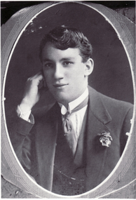
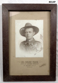 Bendigo Military Museum
Photograph - PHOTOGRAPH WW1, FRAMED, Post WW1
Walter Peake No 6/1688 N.Z.E.F. He was from Bendigo and enlisted in New Zealand. He was " Mentioned in Despatches". This framed photo was one of a number that originally hung in the foyer "Gallery of Honour" at the Soldiers Memorial institute Pall Mall Bendigo which is now the Bendigo Military Museum. Refer Cat No 8003. Refer also 1794, 1793.2, 1791.3, 1792P. These items came into the Museum since it opened in 1998.Portrait photo, B & W set on a cream background re W Peake. Photo is in a dark stained wood frame. Brown wooden frame - glass front - cardboard backing. Head and shoulder, sepia photo in uniform. Mounted on fawn cardboard. By Bartlett Bros, Bendigo"Cpl Walter Peake Died of Wounds received in action 1.6.1917"brsl, smirsl, n.z.e.f -
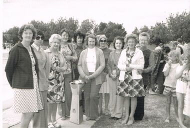 Bendigo Historical Society Inc.
Photograph - BERT GRAHAM COLLECTION: GROUP PHOTO
Black & white photograph, Bert Graham Collection, a group of ladies surrounding the Ron Davies Commemorative Drinking Fountain, with plenty of others looking on.bendigo, clubs, bendigo east swimming pool -
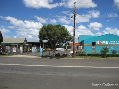 Melton City Libraries
Photograph, Home Hardware, Unknown
Mary Dowling and John Luby had a cottage built on Reserve Rd Melton, the current site of the hardware storelandscapes of significance -
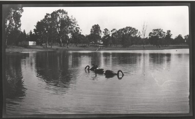 Rutherglen Historical Society
Photograph - Image, 1930 (Approximate)
Negatives lent by Max Turner, a former resident. Prints donated by Mr. Booth of WangarattaBlack & white, unframed photograph - a view across Lake King with 3 black swans in foregroundlake king -
 University of Melbourne, Burnley Campus Archives
Photograph - Black and white print, Information Branch Victorian Department of Agriculture, Student ID Photographs 1971/1972, 1971-1972
Larger size photographs of students who graduated with a Diploma of Science mainly in 1971, some in 1972.On reverse, "Photograph by Information Branch Victorian Dept of Agriculture Ref. No. D.1870." Names on reverse.students, diploma of science, 1971, 1972 -
Port Melbourne Historical & Preservation Society
Photograph - Graham Street State School, 1950s
Hand coloured photograph of Graham Street State School No. 2932, 1950seducation - primary schools, graham street state school, port melbourne primary school -
Lakes Entrance Regional Historical Society (operating as Lakes Entrance History Centre & Museum)
Photograph, 1/06/1989 12:00:00 AM
Colour photograph of Margaret, Pam, Kerry Robyn Geoffs wife Gaye Pitt nee Carpenter at barbeque at Carpenters Camp Park during the Entrance Centenary celebrations Lakes Entrance Victoriagenealogy -
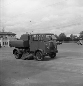 Ballarat Tramway Museum
Negative, Geoff Grant, Mar. 1954
Negative No. 277 and colour print made by colour laser printer (stored in folder ) of MMTB sweeper truck at Caulfield, following renewal of pavement work, March 1954. Photo by Geoff Grant. Envelope that was with negative describes scene as "Special 'yank' for sweeping up sand after bitumen work has been done." Hi res scan of negative and image updated 19/5/2020.trams, tramways, caulfield, sweeping truck, track cleaner -
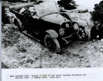 Lorne Historical Society
Photograph, Great Ocean Road. Eastern view. Bogged down in the sand between Fairhaven and Eastern View
Cars being bogged in the sand was a common occurencePhotograph showing man on knees, bogged in sand between Fairhaven and Eastern View ( a common event)great ocean road, fairhaven, eastern view car bogged -
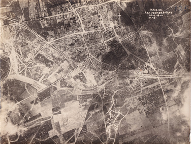 The Beechworth Burke Museum
Photograph
Taken some time between 1914-18, the photograph depicts an aerial view of Villers-Bretonneux in France, a region which was part of the Western Front during World War I. The image mostly shows rural landscape. The Western Front was the main theatre of war during World War I. Following the outbreak of war in August 1914, the German Army opened the Western Front by invading Luxembourg and Belgium, then gaining military control of important industrial regions in France. The German advance was halted with the Battle of the Marne. Following the Race to the Sea, both the French-British and German armies dug in along a meandering line of fortified trenches, stretching from the North Sea to the Swiss frontier with France. The First Battle of Villers-Bretonneux occurred between 30 March - 5 April 1918. It took place during Operation Michael, part of the German Spring Offensive on the Western Front. The offensive began against the British Fifth Army and the Third Army on the Somme, and pushed back the British and French reinforcements on the north side of the Somme. The capture of Villers-Bretonneux, close to Amiens, a strategically important road and rail-junction, would have brought the Germans within artillery-range. In late March, troops from the Australian Imperial Force were brought south from Belgium as reinforcements to help shore up the line. In early April, the Germans launched an attack to capture Villers-Bretonneux. After a determined defence by British and Australian troops, the attackers were close to success until a counter-attack by the 9th Australian Infantry Brigade and British troops late in the afternoon of 4 April restored the situation and halted the German advance on Amiens. The Second Battle of Villers-Bretonneux occurred between 24 - 27 April 1918, during the German Spring Offensive to the east of Amiens. It is notable for being the first occasion on which tanks fought against each other. A counter-attack by two Australian brigades and a British brigade during the night of 24 April partly surrounded Villers-Bretonneux, and on 25 April, the town was recaptured. On 26 April, the role of the Moroccan division of the French army was crucial in pushing back German units. Australian, British and French troops nearly restored the original front line by 27 April.The record is historically significant due to its connection to World War I. This conflict is integral to Australian culture as it was the single greatest loss of life and the greatest repatriation of casualties in the country's history. Australia’s involvement in the First World War began when the Australian government established the Australian Imperial Force (AIF) in August 1914. Immediately, men were recruited to serve the British Empire in the Middle East and on the Western Front. Additionally, the record's significance is enhanced by its depiction of Villers-Bretonneux. The battles that occurred in this town during World War I are especially historically significant to Australia as this is where the Australian Imperial Force had one their greatest World War I victories. An Australian flag still flies over Villers-Bretonneux in the present. Furthermore, a plaque outside the Villers-Bretonneux Town Hall recounts the battles fought to save the town in 1918. Kangaroos feature over the entrance to the Town Hall, and the main street is named Rue de Melbourne. More officially, recognition of the significance of the battle in Villers-Bretonneux is found at the Australian National Memorial, which was built just outside the town. It commemorates all Australians who fought in France and Belgium and includes the names of 10,772 who died in France and have no known grave. Each year, a small ceremony is held at the memorial to mark the sacrifice made by the soldiers. Lastly, the record has strong research potential. This is due to the ongoing public and scholarly interest in war, history, and especially the ANZAC legend, which is commemorated annually on 25 April, known as ANZAC Day.Sepia rectangular photograph printed on matte photographic paper.Obverse: yAE.2.35. / 125 / 62d.2834.35.36.VA.5. / 12.G.18-11 / F.-(?)" /military album, wwi, world war i, villers-bretonneux, australian imperial force, aif, france, war, army, conflict, germany, 1918, battle -
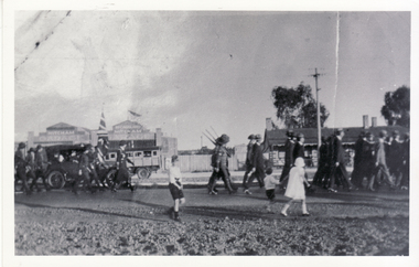 Whitehorse Historical Society Inc.
Photograph, Anzac Day, 1932
Black and white photo of Anzac Day March in Whitehorse Road, Mitcham. Considered a key 'town' event for many years and many returned servicemen from first and second world wars. It is interesting to see the Memorial Hall in the background to the east.anzac day -
 Bendigo Military Museum
Photograph - AUTOMAP 1 Production – Army Survey Regiment, Fortuna, Bendigo, c1978-1980
This collection of 20 photos was most likely taken in c1978. The AUTOMAP 1 computer assisted cartography and mapping system was introduced in 1975. The components of AUTOMAP 1 were the Input Sub-System of four Wild B8s stereoplotters and three Gradicon digitising tables, the Optical Line Following Sub-System – Gerber OLF, the Verification Sub-System – Gerber 1442 drum plotter, the General Purpose Sub-system – HP21MX computer and the Output Sub-System – Gerber 1232 flatbed plotter). The first map was published in 1978 (Strickland 3665-3, 1:50,000). AUTOMAP 1 was the first computer assisted cartography and mapping system utilised by the Survey Corps and was the first system used by Australian mapping organisations. The history of the AUTOMAP 1 system is covered in more detail with additional historic photographs, in pages 116-118 of Valerie Lovejoy’s book 'Mapmakers of Fortuna – A history of the Army Survey Regiment’ ISBN: 0-646-42120-4.This is a set of 20 photographs of Air Survey Squadron military and civilian personnel operating AUTOMAP 1 equipment at the Army Survey Regiment at Fortuna, Bendigo, c1978-1980. Black and white photos .1P to .18P are on photographic paper and were scanned at 300 dpi. Photo .4P is in colour and mounted with a duplicate on manilla card. Black and white photos .19P to .20P are on 35mm negative film and scanned at 96 dpi.They are part of the Army Survey Regiment’s Collection. .1) - Photo, black & white, c1978-1980, Gerber Optical Line Follower (OLF), SSGT John Bennett. .2) - Photo, black & white, c1978-1980, HP21MX computer General Purpose Sub-system. .3) - Photo, black & white, c1978-1980, Gerber OLF .4) - Photo, colour, c1978-1980, unidentified digitising on Gradicon edit table. .5) - Photo, black & white, c1978-1980, Gerber verification drum plotter. .6) - Photo, black & white, c1978-1980, Gerber OLF, CAPT Rob Bridge. .7) - Photo, black & white, c1978-1980, Programming and system administration, SGT Alan Toogood. .8) - Photo, black & white, c1978-1980, Unidentified digitising on Gradicon edit table. .9) - Photo, black & white, c1978-1980, CPL Rick Downie digitising on Gradicon edit table. .10) - Photo, black & white, c1978-1980, SPR Dave Irving digitising on Gradicon edit table. .11) - Photo, black & white, c1978-1980, Gerber OLF and CPL Rick Downie. .12) - Photo, black & white, c1978-1980, 1130 Computer System administration, L to R: unidentified, SSGT Les Dixon, SPR Geoff Havelberg. .13) - Photo, black & white, c1978-1980, AUTOMAP 1 tape administration, Maryanne De Groot. .14) - Photo, black & white, c1978-1980, AUTOMAP 1 tape drive. .15) - Photo, black & white, c1978-1980, HP21MX computer General Purpose Sub-system. .16) - Photo, black & white, c1978-1980, digitising topographic features with a Wild B8 stereo plotter, L to R: unidentified, CPL John Smith. .17) - Photo, black & white, c1978-1980, digitising topographic features with a Wild B8 stereo plotter, CPL John Smith. .18) - Photo, black & white, c1978-1980, digitising topographic features with a Wild B8 stereo plotter, CPL Adrian Rynberk. .19) - Photo, black & white, c1978-1980, Programming and system administration, SGT Alan Toogood. .20) - Photo, black & white, c1978-1980, Gerber OLF, CPL Chris Edwards. .1P to .20P - No personnel are identified.royal australian survey corps, rasvy, army survey regiment, army svy regt, fortuna, asr, automap 1 -
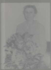 Bendigo Historical Society Inc.
Photograph - AMY HUXTABLE COLLECTION: PHOTOGRAPH AMY HUXTABLE, 1980
Black & White portrait of Amy Huxtable with large bouquet of flowers, under glass with a thin silver & black wooden frame, attached to the back is a small summary of her achievements, markings on rear of image read 'Amy Isobel Huxtable', Donated by Mr Atkinson related to Mary Reibyperson, individual, personal portrait, amy huxtable, amy isobel huxtable -
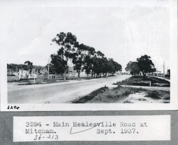 Whitehorse Historical Society Inc.
Photograph, Whitehorse Road, Healesville 1937, 1/09/1937 12:00:00 AM
Black and white photograph of main Healesville Road (Whitehorse road) in September 1937.healesville road, mitcham, whitehorse road -
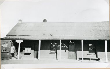 Stawell Historical Society Inc
Photograph, Bolangum Inn at Kanya pre 1970
Bolangum Inn at Kanya pre 1970stawell -
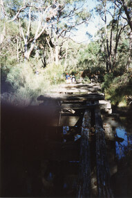 Halls Gap & Grampians Historical Society
Photograph - Coloured, C 1980s
This is a photo of one of the trestle bridges on the Heatherlie Quarry train line. The bridge is located near the current location of "The Pines" campground.The photo is a "front on" of a derelict trestle bridge crossing a shallow creek; many sleepers are missing and thick bush and trees surround the bridge. There are four adults at the end of the bridge, one standing and three seatede. The bottom left hand side of the photo is blurredstructures, bridges, quarrying, heatherlie -
 Whitehorse Historical Society Inc.
Photograph - Black & white photo, Samuel Graham Davidson
Black and white photo of Samuel Graham Davidson, Born 4/5/1896, Land Owner and Resident Whitehorse Road, Simla and King Streets, Blackburn.davidson, samuel graham, landowner, blackburn -
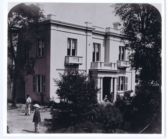 St Kilda Historical Society
Photograph, Eildon, c. 1872
Barham House, now Eildon, built by Edward Green c 1853. Three bay, two storey Regency style house, with single storey portico. This is the original core of the current building Eildon which now has two storey bays at each end of this elevation added c1873. Of note is five children in the foreground. black and white photograph, mounted, copy, good condition.Eildon Grey St -
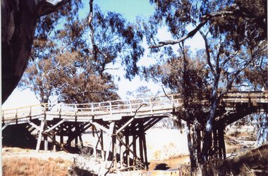 Stawell Historical Society Inc
Photograph, Old Wooden Bridge - over the Wimmera River at Joel Joel -- Coloured
Wooden Bridge - Joel Joel (Wimmera River) stawell shire -
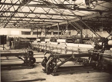 Stawell Historical Society Inc
Photograph, North Western Woollen Mills -- Spinning Machines
North Western Woollen Mills - Spinning Departmentstawell industry -
Lakes Entrance Regional Historical Society (operating as Lakes Entrance History Centre & Museum)
Photograph, Lakes Post Newspaper, 1994
Black and white photograph of Lake Tyers Beach Progress Association memnbers Doug Coole, Herbie Weinzierl, John Wilson, Geoff Morgan working on refurbishing of Bunga Oil Bore site Lake Bunga Victoriafire brigade, construction -
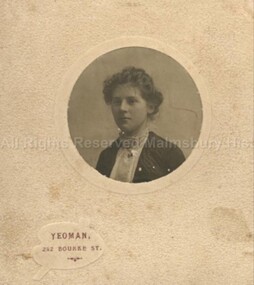 Malmsbury Historical Society
Photograph (Item), B/W Portrait Cora Townsend C1900, Malmsbury c1900
People - "Townsend, Cora" Associated with - Yeoman Melbourne (Photographer) -
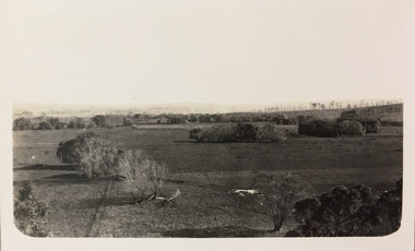 Kew Historical Society Inc
Photograph - Farmland, near or between Bruthen and Swan Reach, 1926
Henry Beater Christian (1886-1962) , was a descendant of one of the earliest settler families in Kew. Employed at the Kew Asylum as a 'public servant', he was a skilled amateur photographer, photographing numerous scenes in Kew and on his travels around Victoria. The majority of his photographs date from 1916 to 1929. His finest photographs are housed in two photograph albums. Digital copy of a photograph from page 31 of the 47-page photograph album containing 261 gelatinous silver images, loaned by Diane Washfold with permission given to digitise and hold a copy in our collection. John Chapman has written in 'Bushwalking Clubs - A Brief History', about the establishment in Victoria of the first bushwalking club in 1888, and the popularisation of bushwalking during the interwar period. Henry Christian's 'walks' appear to have been undertaken solely or with a companion/s. This black and white photo is part of a group of six photos taken on an 18 kilometre walking trip between Bruthen and Swan Reach in East Gippsland in 1926. The route of the walk followed the Tambo River. The photographer focusses the camera view on distant farmland near or between either of the two towns."BRUTHEN TO SWAN REACH 1926"henry beater christian (1886-1962), landscape photography, christian-washfold collection, photograph albums, bushwalking, bruthen, swan reach, tambo river, east gippsland -
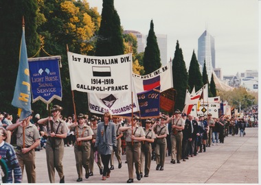 Melbourne Legacy
Photograph, Anzac Day 1997, 1997?
Colour photos of an Anzac Day march with different units and their banners. Including the units from World War 1, the Mine Sweepers Association and HMAS Westralia. Presumably some of the men are legatees. Was with other photos of the day with Jeff Kennett, Bruce Ruxton, John Brumby, and Peter Costello who appear to be the distinguished guests. It is likely to be Anzac Day 1997. It was with photos of Legatee Ron Austin in a jeep so it is believed to be 1997.A record of Anzac Day in the 1990s.Colour photo x 5 of an Anzac Day march with different groups.anzac day, march -
 Kew Historical Society Inc
Photograph - Flooding of shared path at rear of Guide Dogs Victoria, 1993
The land currently occupied by Guide Dogs Victoria was once part of the grounds of the Kew Lunatic Asylum. This includes the land, designated as parkland which adjoins the Yarra River. Original colour small format polaroid photograph of flooding in parkland at the rear of Guide Dogs Victoria in the area now used as the Main Yarra Trail; taken on 16 September 1993."Flooding of shared path on 16.9.93 / Rains 15.9.93 - rear Guide Dogs [Victoria] land"yarra river -- floods -- kew (vic.), guide dogs victoria, main yarra trail, chandler park