-
 Whitehorse Historical Society Inc.
Legal record - Land Title, Certificate of Title
Certificate of Title to Roger Robert Charles Jeanne de Stoop and Wivine de Stoop for land in Joseph Street Blackburn, and transfer of land to Tadedor Constructions Pty Limited, also transfer of land from Tadedor Constructions to the City of Nunawading.Certificate of Title to Roger Robert Charles Jeanne de Stoop and Wivine de Stoop for land in Joseph Street Blackburn, and transfer of land to Tadedor Constructions Pty Limited, also transfer of land from Tadedor Constructions to the City of Nunawading.Certificate of Title to Roger Robert Charles Jeanne de Stoop and Wivine de Stoop for land in Joseph Street Blackburn, and transfer of land to Tadedor Constructions Pty Limited, also transfer of land from Tadedor Constructions to the City of Nunawading.de stoop, wivine, de stoop, roger, land titles, virgilia street blackburn, city of nunawading, tadedor constructions pty limited -
Port Melbourne Historical & Preservation Society
Plan - Air raid shelter, Engineering Department, City of Port Melbourne, Shelter Type 'A', 7 Jan 1942
Plan for air raid shelter comprising 5'3" reinforced concrete pipe with seating - probably for schoolyard. January 1942.war - world war ii, built environment, city engineers, fred cook -
Glenelg Shire Council Cultural Collection
Plan - Ship Plan / Mould, n.d
Wooden pattern for mould for boat fitting. Two similar rectangular pieces joined in parallel by two small, similar rectangular pieces, at right angles to the larger rectangles, creating an open box-like shape. Painted white. -
Port Melbourne Historical & Preservation Society
Plan - Tramway, Normanby Road, Ingles Street to Boundary Street, Port Melbourne, 14 Mar 1893
Plan of tramway in Normanby Road from Ingles Street to Boundary Street, together with written specification for works attached (Reg 66.2), 1893.A.V. Heath (Town Surveyor) J.J. Bartlett (Mayor)engineering - roads streets lanes and footpaths, transport - tramways, town planning, town clerks, mayors, arthur victor heath, james john bartlett -
University of Melbourne, Burnley Campus Archives
Legal record, Tiered Lecture Theatre, 1990-1991
lecture theatre, contract, light framed lecture theatre -
Moorabbin Air Museum
Plan (item) - C.A.C Stub Shaft - Power Unit
EX250011 -
 Greensborough Historical Society
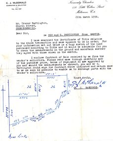
Legal record - Letter, C. J. McDonald, C.J. McDonald to Trevor Partington 1958, 26/03/1958
A solicitor's letter to Trevor [and Gary] Partington in preparation for a land transaction from vendor "Martin". The location of the land is not clear. It is possible that this land was purchased by Alan Partington in his adult children's names.Part of many land deals made by the Partington family in the sale of the original Greensborough farmland. Solicitor's letter, black text on white paperHand drawn plan of property.alan partington, william alan partington, partington family, land deals greensborough -
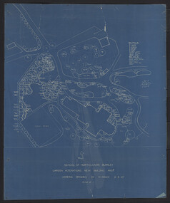
University of Melbourne, Burnley Campus Archives
Plan, Horticultural Project Conservation and Management Plan Wombat Park, c. 1990
Photocopies of plan drawn by M. Gilbert of Survey Area C-G, with numbered plant list.m. gilbert, wombat park, management plan -
Glenelg Shire Council Cultural Collection
Plan - Ships Plans / Moulds, n.d
Wooden pattern for mould for boat fitting. Hollow cylinder attached to curved piece, white tapers at other end. Section of shaped wood attached to either side of curved section. Painted white on top, sides and underside unpainted. -
 Port Melbourne Historical & Preservation Society
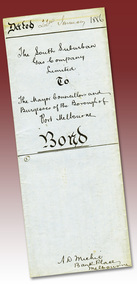
Legal record - Contract, South Suburban Gas Company Limited, gas supply to Port Melbourne, 22 Jan 1886
Contract of supply of gas to Port Melbourne 1886 - South Suburban Gas Company LimitedBlind embossed company sealutilities - gas, local government - borough of port melbourne, south suburban gas company ltd, a d michie -
University of Melbourne, Burnley Campus Archives
Plan, David Reid, Dandenong College of T.A.F.E. Landscape Design, 1988
Student plans. (1) Master Plan by David Reid for Landscape Graphics 4, dated 17.10.1988. Scale 1:250. (2) Master Plan No 2 by L. Garnett October 1988. Scale 1:250. (3) Master Plan by Steve Soso for Landscape Graphics 4 dated 18.9.88. Scale 1:250.david reid, steve soso, landscape design -
 Kew Historical Society Inc
Plan - Subdivision Plan, Riversdale Estate, 1939
The Kew Historical Society collection includes almost 100 subdivision plans pertaining to suburbs of the City of Melbourne. Most of these are of Kew, Kew East or Studley Park, although a smaller number are plans of Camberwell, Deepdene, Balwyn and Hawthorn. It is believed that the majority of the plans were gifted to the Society by persons connected with the real estate firm - J. R. Mathers and McMillan, 136 Cotham Road, Kew. The Plans in the collection are rarely in pristine form, being working plans on which the agent would write notes and record lots sold and the prices of these. The subdivision plans are historically significant examples of the growth of urban Melbourne from the beginning of the 20th Century up until the 1980s. A number of the plans are double-sided and often include a photograph on the reverse. A number of the latter are by noted photographers such as J.E. Barnes.The Riversdale Estate in Hawthorn created a subdivision of 20 allotments bordering on Riversdale Road and Riversdale Court (which was created by the subdivision). The Locality Plan at right lists the major public buildings in the area: Burnely Horticultural Gardens, Hawthorn Tram Depot and Railway Station, Scotch College and the River Yarra and The Boulevard.subdivision plans - hawthorn, riversdale estate -
 Mission to Seafarers Victoria
legal record (item) - Register, marriages, Register No. 1, No. 1-11 (Dec. 7th 1915 to July 27th 1921), c.1915
This is a register of weddings performed at the Mission to Seafarers at the Port Melbourne site. The register names all parties involved including bride, groom, celebrant, witnesses, bride and groom's parents and addresses at the time. It also outlines previous marital status, employment details and other personal details. Historical record of marriages performed at the Mission to Seafarers commencing in 1915.Purple stamp in top left-hand corner of a flag with a flying angel. "From the Mission to Seamen Melbourne" Handwritten: Register No. 1, No. 1-11 (Dec. 7th 1915 to July 27th 1921)st nicholas chapel, port melbourne, mission to seamen, seamen's mission, mission to seafarers, marriage, register, wedding, st james, anglican church, dio-marriages, dio-archives -
Port Melbourne Historical & Preservation Society
Plan - Soundings, Yarra River, Operation Division, Port of Melbourne Authority, Jul 1987
Port of Melbourne Authority. Plan: soundings of Yarra River at entrance Beacon No 23melbourne harbor trust - port of melbourne authority, beacon no 23 -
 Kew Historical Society Inc
Plan, Sydney Arnold Best & Co, Field Place, Kew, c.1929
Pru Sanderson, in her groundbreaking ‘City of Kew Urban Conservation Study : Volume 2 - Development History’ (1988), summarised the periods of urban development and subdivisions of land in Kew. The periods that she identified included 1845-1880, 1880-1893, 1893-1921, 1921-1933, 1933-1943, and Post-War Development. These periods were selected as they represented periods of rapid growth or decline in urban development. An obvious starting point for Sanderson’s groupings involved population growth and the associated economic cycles. These cycles also highlighted urban expansion onto land that was predominantly rural, although in other cases it represented the decline and breakup of large estates. A number of the plans in the Kew Historical Society’s collection can also be found in other collections, such as those of the State Library of Victoria and the Boroondara Library Service. A number are however unique to the collection.The Kew Historical Society collection includes almost 100 subdivision plans pertaining to suburbs of the City of Melbourne. Most of these are of Kew, Kew East or Studley Park, although a smaller number are plans of Camberwell, Deepdene, Balwyn and Hawthorn. It is believed that the majority of the plans were gifted to the Society by persons connected with the real estate firm - J. R. Mathers and McMillan, 136 Cotham Road, Kew. The Plans in the collection are rarely in pristine form, being working plans on which the agent would write notes and record lots sold and the prices of these. The subdivision plans are historically significant examples of the growth of urban Melbourne from the beginning of the 20th Century up until the 1980s. A number of the plans are double-sided and often include a photograph on the reverse. A number of the latter are by noted photographers such as J.E. Barnes.An unnamed subdivision in Studley Park including five lots for sale in Studley Park Road, Highfield Grove and Tara Avenue. Unidentified on the plan, but clearly existing, are the Henty family mansion of Field Place and Tara Hall in Studley Park Road. The first attempted subdivision of Tara Hall was advertised in 1927 in which Lots 5, 6 and 7 in this plan were also advertised. Unusually, Lot 2 in Studley Park Road was created from the northern part of the Henty mansion, rather than Tara Hall. In the subdivision, lots were advertised at varying prices, with the highest price for land being Lot 2 in Studley Park Road. The plan notes that only one villa is to be allowed on each allotment.subdivision plans - kew, field place subdivision -- studley park – kew (vic.), highfield grove – kew (vic.), tara avenue – kew (vic.) -
Ringwood and District Historical Society
Legal record - Conditions of Sale (C.E.Carter), Ringwood , Lot 3 on Plan of Subdivision No 3916441, Mr W. Ballock to Mr & Mrs Bott circa 1943
Particulars and Conditions of Sale of Property , from Mr W.Ballock to Mr & Mrs Bott. -
University of Melbourne, Burnley Campus Archives
Plan, Gerner Sanderson Faggetter Cheesman, Hay's Paddock, 1981
Sketch Plan dated September 1981, by Gerner Sanderson Faggetter Cheesman, Drawing No 200.01. Scale 1:100.gerner sanderson faggetter cheesman, hay's paddock, kew, parks -
 University of Melbourne, Burnley Campus Archives
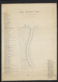
Plan, Burnley Horticultural School. Site for Experimental Plots, 1930
Pencilled notes: Planted 1930 (according to Mr. Fish). Revised 1932, 1937. Still in existence 20-9-50 A.J.T[eese] Plan with Swan St on N side and curved metal road from N to S. Details of plants on either side numbered with position marked on plan. Scale 1 inch to 20 feet. Sealed in plastic cover. Used for Centenary display. On reverse side: "Entrance & Garden Outlay"burnley horticultural school, experimental plots -
Moorabbin Air Museum
Plan (item) - Bristol Aeroplane 170 schematic drawings, Assy. Real Spar Starboard
Bristol Aeroplane Company Ltd -
 Ringwood and District Historical Society
Plan, Ringwood Station Estate, Subdivision, Ringwood, Victoria - circa 1925
ID 5224 note: Further information relating to squares marked H, F, G, J, and K included in ID 5225 - Ringwood Shop and Dwelling Estate.Hand drawn plan of Ringwood Station Estate showing allotments for sale, with two typed pages attached showing land title information and sale prices.Drawn by Edyth Greenwood, phone 988 Central. Subdivision includes Station Street, Pitt Street, Bedford Road, Wantirna Road, James Street, William Street (later Kendall Street), Greenwood Avenue, Ellison Street, and Haig Street. Circles denote blocks for sale. Squares denote house properties for sale. Other features marked include location of businesses along Main Street (Maroondah Highway), cool store, railway station, shop and police station on Bedford Road, church on Station Street, site of schoolmaster's residence and State School, and location of proposed public baths. Ryner & Langford, Solicitors -
Port Melbourne Historical & Preservation Society
Plan - Port Melbourne Life Saving Club, Graeme Bentley Landscape Architects, Mar 1993
.01 - Plans and landscape drawings for Port Melbourne Life Saving Club, March 1993, 10pp .02 - One sheet "Landscape Master Plan" Port Melbourne Foreshorenatural environment - beaches and foreshore, built environment - recreational facilities, societies clubs unions and other organisations, graeme bentley - landscape architects -
Glen Eira Historical Society
Plan - Centre Road, Bentleigh
Two copies of a one page printed advertisement for the auction of six shops on Centre Road, Bentleigh near Jasper Road to be held on 07/03/1950. The advertisement includes a plan (51mm x 127mm) of the sitesmeldrum w, centre road, bentleigh, plans, advertisements -
 University of Melbourne, Burnley Campus Archives
Plan, Hilda Marriott ( Dance), Garden Plans by Hilda Marriott (Dance), 1947-1981
Set of 8 plans, including blue-prints, of various gardens, dated c. 1947 - 1981. See paper catalogue for complete list.Plans by Hilda Marriott Dance (1) Sketch plan and 2 blueprint copies of School of Horticulture Burnley. Garden Alterations New Building Area, Working Drawing by H. Dance, Scale ⅟₂₀"=1', 2/4/47, on reverse handwritten,"Proposed Garden Lay-out for New School Building (H. Dance-plan)." (NB Emily Gibson was also involved in the planning of this site.) (2) Tracing paper, paper and blueprint copies of Ararat & District Hospital Garden Plan - MacDonald Memorial & Court, Landscape Architect - H. Dance, Scale 1 inch=8 feet. Includes handwritten note, "Replacement for Ararat Hospital Nov. 1979," list of plants. (3) Blueprint Proposed Design for Garden Watermill Farm, Newbury for Norman Gadsden Esq., Scale ⅟₄₀"=1 ft. (4) Sketch Plan for Garden, Barcombe, Buangor - January 1981 by Hilda Marriott, Scale - Approximate Only - 1:40. (5) Tracing paper copy of plan of Garden at Plumhill, Templestowe, for Mr. & Mrs. Colin Smith. Hilda Dance, Designer 26/4/47, Scale ⅛"=1'. (6) Blueprint Garden House - Sketch. (7) Tracing paper and paper copies Ararat Medical Centre Courtyard Garden, Landscape Architect - Hilda Marriott, Scale - 1:25, Date 8.5.79. (8) Tracing paper copy National Trust of Australia (Victoria) The Heights, Newtown, Geelong Garden Plan, Scale 1:250, Drawn by - Hilda Marriott, Date 12.10.79.(1): on reverse handwritten,"Proposed Garden Lay-out for New School Building (H. Dance - plan)." (2): Includes handwritten note, "Replacement for Ararat Hospital Nov. 1979," list of plants.hilda marriott ( dance), burnley school of horticulture, students -
Moorabbin Air Museum
Plan (Item) - CAC plans include CA25 Sopwith Hawker Hurricane fuel injection system Fyling controls AA 107 CA31 Mustang, CAC various aircraft plans
-
Bendigo Historical Society Inc.
Plan - SANDHURST BOYS CENTRE COLLECTION: MASTER PLAN
Government of Victoria. Public Works Department. Master plan for the Loddon-Campaspe Regional Service Sandhurst Centre. [produced by] J Swan Chief architect, approved by B.W. Swan. Shows a brick Administration building, 6 [accommodation?] brick buildings (to be remodelled), the site for a new kitchen & amenities building, TDU no 1, BMU, TDU no 2 (new buildings), sites for maintenance workshops, vegetable garden. Also shows a residence, garage, recreation oval, with 3 existing weatherboard buildings, galvanised iron building, a weatherboard grandstand, a galvanised iron shed, fowl shed, 14 galvanised iron buildings [probably Nissan huts] and 2 toilet blocks. Location unknown 16.02.2023.bendigo, institutions, sandhurst boys centre, victoria public works dept; plans; sandhurst boys centre; j.swan -
Kew Historical Society Inc
Plan - Burke Road Junction Estate, East Kew, 1940
Subdivision plans and real estate flyers/brochures reveal a number of aspects of urban development and history. The Kew Historical Society's collection of these plans, as well as advertisements extracted from magazines, cover key aspects of community development and architectural history of Kew and Kew Eat as well as surrounding suburbs. While most of the plans in the collection were gifted to the Society by the former City of Kew, a number of other plans and advertisements have been donated by individuals, of which this is an example.Original 4-page bifold brochure advertising the Burke Road Junction Estate in Kew East. Advertised for sale in 1940, the estate comprised 16 'Central Allotments' fronting High Street, Kilby Road, and Glass Street. Pages 1 & 4, the front and back covers, includes a panoramic photograph of the junction which features a number of shops still extant, but also with buildings long demolished and redeveloped. These include the petrol station and the dairy on the southeast and southwest corners of Burke Road and High Street/Doncaster Road. The dairy includes a statue of a cow on its roof. Pages 2 & 3 include a detailed plan of the estate. subdivisions -- kew east (vic.), burke road junction estate -
Glenelg Shire Council Cultural Collection
Plan - Ship Plan / Mould, n.d
Wooden pattern for mould for boat fittings. Similar to 6418. -
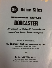 Kew Historical Society Inc
Plan - Subdivision Plan, New Haven Estate, Doncaster
Subdivision of 86 home sites in Doncaster.Undated subdivision plan for 86 home sites in the New Haven Estate in Doncaster. The 2-sided plan has a locality plan on the reverse.The land for sale would appear to be in George StreetNilnew haven estate - doncaster (vic), subdivision plans - doncaster (vic) -
Port Melbourne Historical & Preservation Society
Plan - Proposed Alterations, Port Melbourne Town Hall, B S Elms & Co Pty Ltd, 23 Jun 1966
From a set of two drawings, 1966 - plans - details of alterations to Council Chamber, Councillors Room and first floor of Town Hall - not proceeded with. port melbourne town hall -
Glen Eira Historical Society
Plan - St James Parade, 12, Elsternwick
Hand drawn pencil plan of 12 St. James Parade, Elsternwick, unknown author and undated.st. james parade, elsternwick, plans