-
 Glenelg Shire Council Cultural Collection
Map - Map - Portland, Victoria, n.d
Map of Portland, produced as an advertising medium by Portland Chicken Inn. Green card, dark blue print. Image of Portland Harbour on front, street index on back, open to Portland map, Chicken Inn marked on map. -
 Bacchus Marsh & District Historical Society
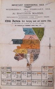
Map, Important Subdivisional Sale at Bacchus Marsh, Wednesday 28 February, 1912
In the later 19th century and early 20th centuries Thomas Cain was a major farmer in the Bacchus Marsh district and a significant participant in community life and affairs. The sale of some of his most significant properties towards the end of his life generated wide interest in Bacchus Marsh and beyond.Paper. 33cm x 21cmnon-fictionIn the later 19th century and early 20th centuries Thomas Cain was a major farmer in the Bacchus Marsh district and a significant participant in community life and affairs. The sale of some of his most significant properties towards the end of his life generated wide interest in Bacchus Marsh and beyond.land sales, thomas cain, landholders -
Glenelg Shire Council Cultural Collection
Map - Map - Portland, 1950s
White card with 2 maps of Portland; larger one showing the town and harbour, smaller one of town, Portland Bay, Bridgewater Bay, Nelson Bay, Lawrence Rocks. Also Portland phone numbers: Ambulance Hospital, Police, Fire, Taxi, Electricianmap, portland, portland harbour, cape bridgewater, south west coastline -
 Bendigo Historical Society Inc.
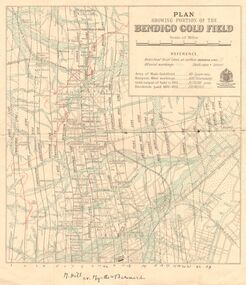
Map - DEPARTMENT OF MINES VICTORIA : PLAN SHOWING PORTION OF THE BENDIGO GOLD FIELD
Department of Mines Victoria. Plan showing portion of the Bendigo Gold Field. On the back is written, in ink, J. J. Tyler 1937 Northern Area. (He was a teacher at Bendigo High - see donation notes). Across the bottom of the map is written ' M. Hill cr. Myrtle & Barnard' .The named reef lines have been numbered with ink across the bottom of the map. The gullies have been coloured with green pencil and a red pencil line is drawn through the western side of the map. Additional information: anticlinal axial lines at surface, alluvial workings, shaft sites, area of Main Goldfield, Deepest mine workings, Gold output of field to 1935, and Dividends paid 1870 - 1935.bendigo, gold mining, bendigo gold field. gold mining. tyler, j. j. -
 Bendigo Historical Society Inc.
Map - GREAT EXTENDED HUSTLER'S MINE - PLAN OF THE GREAT EXTENDED HUSTLER'S MINE
Plan of the Great Extended Hustler's Mine. Bulletin No 33, Plate No XI. Shows No 2 Shaft, Latham & Watson's Shaft, levels and their depths and some geographical features. Geographical Survey of Victoria emblem and signed by H A Whitelaw, Underground Survey Office, Bendigo, September 1913. Has reference to photos.mining, parish map, great extended hustler's mine, no 2 shaft, latham & watson's shaft, geological survey of victoria, underground survey office bendigo, h a whitelaw -
Stawell Historical Society Inc
Map, Agricultural Area of Lake Wilson, 1865
Agricultural Area of Lake Wilsonstawell -
Whitehorse Historical Society Inc.
Map, Pocket guide to walking and wheeling in Whitehorse, 2008
Map showing walks, cycle tracks and off lead areas for dogs in Whitehorse.Map showing walks, cycle tracks and off lead areas for dogs in Whitehorse. Includes walking and cycling groups.Map showing walks, cycle tracks and off lead areas for dogs in Whitehorse. walking trails, bicycle paths, city of whitehorse -
Bendigo Historical Society Inc.
Map - JOHN WILLIAMS COLLECTION: PHOTO-MAP OF BENDIGO, 2007
Map, Photo-map of Bendigo,Australian Government Department of Defence,prepared and published by the Defence Imagery and Geospatial Organisation 2007.Copyright Commonwealth of Australia 2007.Australia Photomap 1:15 000. Edition 2-DIGO. WGS84.Grid 1000 metre UTM Zone 55. (number 407 in map cupboard 1)Defence Imagery & Geospatial Organisationmap, bendigo, city streets -
 Ballarat Tramway Museum
Map, Ken McCarthy, Map of Proposed National Park Line - SPER, mid 1950's
Hand drawn plan on plain foolscap paper of proposed tram line from Loftus to View Point within National Park for South Pacific Electric Railways - with notes, proposed destination roll.trams, tramways, sper, national park line, loftus, destination roll -
 Bendigo Historical Society Inc.
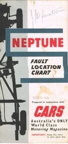
Map - J W SWATTON COLLECTION: MAPS
Seven maps of various sizes. Map of the City of Ballarat, Victoria, Road Condition Map of Victoria including Melbourne-Cairns & Melbourne-Adelaide, Neptune Fault Location Chart, Grampians District Map, Racv Tour Planning Map Showing Road Conditions for Victoria, NSW and Queensland and Mt Macedon & District. Two of the maps have J W swatton & J Swatton written on them.j w swatton collection, racv, mobil, neptune, a r blair, j ewins & sons pty ltd, berry anderson & co -
Stawell Historical Society Inc
Map, Physical description Concongella South, Counties of Borung & Ripon, 1957
Concongella South, Counties of Borung & Riponstawell -
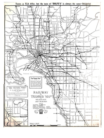
 Kew Historical Society Inc
Map, Osboldstone & Co Pty Ltd, Railway and Tramway Map of Melbourne and Suburbs With Tram Timetables, 1917
The Railway and Tramway Map of Melbourne and Suburbs With Tram Timetables lists existing Cable Tram Services before the entire network was electrified. By 1917 the tramways system was divided into regions including: the Melbourne Cable Tram Service; Prahran - Malvern Electric Trams; Hawthorn Electric Trams; Melbourne, Brunswick and Coburg Electric Trams; and Brighton Beach Electric Trams. The old Outer Circle railway line is marked as ending in Deepdene, with the remainder of the line to Fairfield marked as 'Unused'. The Kew tram along High Street in 1917 ended at the Harp Junction. The Kew Spur Line is also marked on the map.The Railway and Tramway Map of Melbourne and Suburbs With Tram Timetables is historically significant as it captures at a point in time, 1917, the development of public transport infrastructure in Melbourne. As such it illustrrates the theme: Connecting Victorians by transport and communications.Printed card-covered pocket sized map that folds out with three horizontal and vertical folds. Colour map, with scale, of the rail and tram networks on one side and sixteen sections of black and white printed text and timetable information on the reverse.railway maps -- melbourne (vic.), tramways maps -- melbourne (vic.), public transport -- melbourne (vic.) -- 1910-1920, cartography -
 Ringwood and District Historical Society
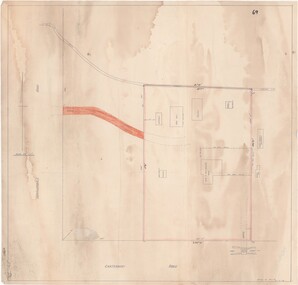
Map - Ringwood Animal Welfare Clinic, 1958 Land Survey Drawing, Ringwood, Victoria
Plan of driveway and property east of Heatherdale Road and Canterbury Road corner, with details of house, shed, bungalow, dog pen, kennels and enclosures.Survey by H.L.M. 31-7-58. Scale 20'=1" -
Whitehorse Historical Society Inc.
Map, Canterbury Road, Vermont, c1970
Enlarged aerial photo of intersection of Canterbury and Boronia Roads. State Aerial Survey, Melbourne 1970 project.Enlarged aerial photo of intersection of Canterbury and Boronia Roads. State Aerial Survey, Melbourne 1970 project.Enlarged aerial photo of intersection of Canterbury and Boronia Roads. State Aerial Survey, Melbourne 1970 project.canterbury road, vermont, boronia road, vermont, mitcham road, vermont, frances avenue, vermont, nurlendi road, vermont, webb court, vermont, vermont primary school, no. 1022, aerial photographs -
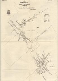 Bendigo Historical Society Inc.
Map - COMET MINE - PLAN OF COMET MINE
Plan of the Comet Mine on the Hustler's Line of Reefs Bulletin No 33, Plate No XXIII. Map shows depths, Lightning Hill Anticline, Hustler's Anticline and approximate Lease Boundary. Signed by H. S. Whitelaw, Underground Survey Office Bendigo, September 1913. United Hustler's & Redan Co and Hustler's Reef Co also named on map. This item has not been scanned or photographed.Geological Survey of Victoriamining, parish map, hustler's line of reefs, comet line plan belletin no 33 plate no xxiii, lightning hill anticline, hustler's anticline, united hustler's & redan co, hustler's reef co, h s whitelaw, underground survey office bendigo september 1913 -
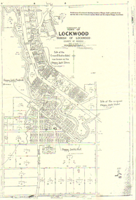 Bendigo Historical Society Inc.
Map - LONG GULLY HISTORY GROUP COLLECTION: LOCKWOOD TOWNSHIP
Copy of a map of Township of Lockwood, County of Bendigo. Printed at the top of the map is: Parish map of Lockwood showing location of Happy Jack's paddock & hut and the sites of the Crown & Anchor Hotel and the original Happy Jack Hotel. Written on the map with arrows pointing to the site is: Happy Jack's Paddock, Site of the original Happy Jack Hotel and Happy Jack's Hut. An outline of Happy Jack's Paddock is drawn in.bendigo, history, long gully history group, the long gully history group - lockwood township, crown & anchor hotel, happy jack hotel, happy jack store, county of bendigo -
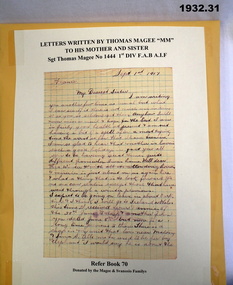 Bendigo Military Museum
Literary work - LETTERS WW1, 1914-18 (exact)
Letters written by Thomas Magee No 1444 enlisted in F.A.Brigade 2 Ammunition Colunm AIF on 20.8.1914 age 26 years. Embark for Egypt 20.10.1914, embark for Gallipoli 4.5.1915, hospital with Mumps 19.2.1916, transfer to 4th Div Artillery 27.2.1916, embark for France 1.4.1916, promoted Bombadier 2.2.1917, promoted Cpl 30.9.1917, awarded the Military Medal (MM) at Westhoek 4.10.1917, promoted T/Sgt 23.10.1917, WIA Gassed 3.11.1917, rejoins unit 13.3.1918, promoted Sgt 7.5.1918, to No 2 Army Field rest Camp 16.7.1918 to 2.8.1918, to England 13.10.1918 special leave 1914 men, hospital with Influenza then Pnuemonia and dies in England on 25.10.1918.Series of letters, 32 in total written by Thomas Magee MM to his sister & mother. All letters are either pencil, red & black ink. Some are parts of letters with no dates or who to. The letters begin Tues 25th 1914 possibly August and continue through to Sept 1918. Letters are various sizes, some on blue paper, some on note pad size & graph paper.documents, letters, mm, -
Bendigo Historical Society Inc.
Map - LYELL, 16/04/1935
Map: Lyell, County of Bendigo. Parish plan ( number 166 in Map Cupboard 1)map, bendigo, parish plan, lyell, county of bendigo -
Moorabbin Air Museum
Map (Item) - Maps of Northern Australia and New Guinea, AUS RNC 5 and 6 radio navigation maps
-
 Halls Gap & Grampians Historical Society
Map - Coloured
Background on Bridle Path up Stony Creek Gorge Pre 1840 C. B. Hall, squatter on Mokepilly Run 1841-1842, first European to discover the Fyans Creek valley, the entrance of which became known as Hall's Gap. He later recorded that he followed a number of tracks which he assumed had been made by the Aboriginies and described one as "leading up a wild romantic glen and over on to the source of the Glenelg River". This could well have been the route taken up Stony Creek gorge by the first timber-cutters in this part of the Grampians to the saddle between the Wonderland and Mt. Difficult ranges known as Valley Gap 1850s/60s Timber cutters and shingle splitters were reported to be moving into the eastern side of the Grampians and by the mid 1860s there were a number of families connected to the supplying of timber to Pleasant Creek living in the "Hall's Gap ranges". John Wakeham, the first store owner in Pleasant Creek in 1854, established a timer-mill in upper Stony Creek Gorge in the late 1850s. Wakeham is credited for the clearing and levelling of the first bridle-path up the gorge. 1870s By the mid 1870s the track had been extended over Valley Gap to the Victoria Forest (the upper region of the Victoria Valley). McKeon's bullock team was known to have hauled red gum from the Valley to Stawell in the late 1870s and the 1880s. 1880s In 1887 an article in the Pleasant Creek news describes the Stony Creek Gorge track as "being a ledge alongside the mountain range, formed in the early days with the aid of earth and timber, along which the bullock teams used to travel to Horsham and plains of the Wimmera beyond." 1890s Gold was discovered in the catchment area of Stony Creek and by the end of the 1890s a new track was built from "near the junction of Fyan's and Stony Creeks, up the gorge to the diggings settlement. The mining Department had paid L300 for its construction and, when completed, the track was "three miles and 30 chains in length, the side cuttings at the narrowest part being 10 feet between" and "the watercourses which cross the track at various points" having been "filled up with rocks rolled down the sides of the hills, and consequently there can be no damage caused by bushfires which destroyed the former wooden bridges erected on the old track to Wakeham's saw-mill, the remains of which are still to be seen at the side of the diggings" The article goes on to further describe the track as one which "can with ease travel with a two horse conveyance either up or down" and that the workmen engaged in the construction of the track would be attending "a ball that night at McKeon's farm near the mouth of the gap to celebrate the successful completion of the undertaking". 1900s At what time the bridle path was extended beyond Valley Gap to the Wartook basin on the Mt. Difficult Range has not yet been determined. However, it is known that, by the turn of the century, people were travelling between Halls Gap and the caretakers' residence at Wartook Reservoir along what was now known as the "Bluff Road. Wartook's embankment had been constructed in 1887 and at that time there was already a track from Rosebrook Station homestead (near the present day Wartook Pottery) to the reservoir. Philip Rose owned both Rosebrook and Wartook Stations from the mid 1840s to the late 1850s and had regularly leased the Wartook basin to Cobb & Co. to rest horses there. 1920s Following the war of 1914-1918, tourism really took off in the Grampians, and Halls Gap rapidly grew. People would travel as far as they could on the many tracks then hike to the many lookouts being discovered by local tour guides. This led to the need for access across the range so that horse riders and the increasing number of vehicles could travel between Horsham and Halls Gap. To this end, the Bluff Road was improved and extended on 1929 and at its opening in March, 1930, by Lady Somers it was renamed the Mt. Victory Road.Map of Mt Victory Road and othersaccess routes, mt victory rd, bridle path, roads -
Clunes Museum
Map - CLUNES TOWN HALL AND COURTHOUSE COMPLEX, FALKINGER ANDRONAS
CLUNES TOWN HALL AND COURT HOUSE COMPLEX - PROPOSED REFURBISHMENT ARCHITECT DRAWINGS: ,1 SITE AND ROOF PLAN .2 GROUND FLOOR PLAN .3 EAST ELEVATION .4 WEST ELEVATION .5 ABC/FASSADEStown hall and courthouse drawings, proposed refurbishment -
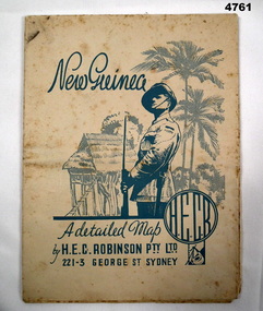 Bendigo Military Museum
Map - MAP, NEW GUINEA, H.E.C Robinson PTY LTD, Post WW2
Map Robinsons “Territory of New Guinea and Papua” 0ff white colour rectangular shape, shows New Guinea, Papua, New Britain, New Ireland & Bougainville, colours red, orange, yellow, green designating boundaries, when folded one section has in blue a depiction of An Australian Soldier with palm trees & native hut.“Map No 315”maps, new guinea, robinsons -
 Ringwood and District Historical Society
Map, Proposed Subdivision - Hilltop Estate, Heathmont, Victoria - circa 1925
Plan of Part of Crown Allotments 16 & 18, Parish of Ringwood, County of Mornington. Subdivision includes Site for Heathmont Station, Heathmont Road, George Street, Lilian Street, Edith Street, Edna Street, Great Ryrie Street. Inset locality plan also shows nearby Electric Railway Estate and Heathmont Station Estate. L.H. Webber, Licensed Surveyor, 440 Little Collins Street, Melbourne. -
Bendigo Historical Society Inc.
Map - GEORGE BLACK 2 REVIEW, 1859-1897
DVD. George Black 2 Review. George Black 1897. William Larritt Drawings 2, William Larritt Drawings 1859. Plus additional data. -
 Melbourne Tram Museum
Map, Gawler and Drummond Architects, "Railway and Tramway Map of Melbourne and Suburbs", 1920's?
Map - photocopy - titled "Railway and Tramway Map of Melbourne and Suburbs", c1920 showing railways, cable, electric tramways and authorised electric additions. Shows the South Melbourne St Kilda tram line and some lines in the Footscray area as dotted. Prepared by Gawler and Drummond Architects. Has an advertisement for "Rolfes" tea along the top edge and "See Victoria First" - Government Tourist Office, corner of Swanston and Collins St.trams, tramways, map, footscray, st kilda, new tramway, melbourne, tourism -
Whitehorse Historical Society Inc.
Map, Map of City of Nunawading, n.d
Hand drawn map of City of Nunawading showing heights above sea level.city of nunawading, maps -
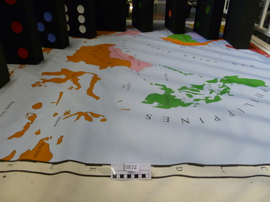 National Vietnam Veterans Museum (NVVM)
Map, Flawed Theory, 2009
Large PVC 1965 political map of South East Asia with nine large dominoes attached'Asia South East Political 1965'domino theory, 3rar, jones, geoffrey r -
Bendigo Historical Society Inc.
Map - BENDIGO (COUNTY), Circa 1870's
Map:Plan showing the whole of the County of Bendigo-- attached handwritten sheet in the top left hand corner-'Proclaimed Commons Sandhurst District'. Also attached is a separate plan of the parish of Kimbolton (number 262 in map cupboard 1)map, bendigo, parish plan, bendigo, proclaimed commons -
Stawell Historical Society Inc
Map, Section of Map, Stawell including Stawell Rifle Range, 1969
Section of Map, Stawell including Stawell Rifle Rangestawell -
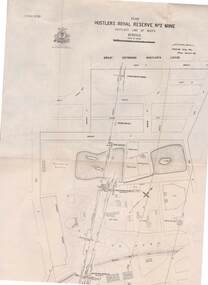 Bendigo Historical Society Inc.
Map - STRUGNELL COLLECTION: HUSTLER'S LINE OF REEFS, BENDIGO, September 1913
Map, Hustler's Line of Reefs, Hustler's Royal Reserve No. 2 Mine, Bendigo.Plate No. V (5).. Great Extended Hustler's Lease, Imperial Hustler's, Hustler's Royal Reserve No. 2 Park & Main Shafts, Fortuna Hustler's Lease.Bulletin No 33 Signed H.A.Whitelaw Underground survey Office Bendigo September 1913Underground Survey Office, Bendigo.map, bendigo, hustler's royal reserve no. 2 mine*