Showing 2382 items in the category Documentation with item type Map
-
 Stawell Historical Society Inc
Map, Section 3 (Taken from Plan No 959), 1894
Section 3 (Taken from Plan No 959)stawell -
Bendigo Historical Society Inc.
Map - CAMPBELL COLLECTION: BENDIGO AND DISTRICT MAPS
Map. Ellesmere, Parish of Ellesmere. Scale 20 chains to 1 inch. Total area 3926 acres. Prepared in W.P.B. from A and P plans. (number 354 in map cupboard 1)map, bendigo, agricultural lands -
Lakes Entrance Historical Society
Map - Lakes Entrance Tourist Area Shire of Tambo
Showing commercial and tourist area opportunitiestourism, commerce, settlement -
Whitehorse Historical Society Inc.
Map, Map of East and South eastern suburbs of Melbourne, 1930s
Map of suburbs of Melbourne from Kew to Ringwood and South Morang Station to East Oakleigh.Map of suburbs of Melbourne from Kew to Ringwood and South Morang Station to East Oakleigh.Map of suburbs of Melbourne from Kew to Ringwood and South Morang Station to East Oakleigh.blackburn, mitcham, hawthorn, box hill, doncaster, templestowe -
 Marysville & District Historical Society
Map (Item) - Walking map, Department of Sustainability and Environment, marysville TRAILS, 07-2011
A map showing all the walking trails in and around Marysville and the district. This map was produced by the Department of Sustainability and Environment in July 2011.A map showing all the walking trails in and around Marysville and the district.ISBN 978-1-74287-122-6 (print)marysville, victoria, australia, marysville trails, department of sustainability and environment, parks victoria, steavenson falls trail, beauty spot trail, gilberts gully trail, tree fern gully trail, michaeldene trail, wilks creek trail, keppel lookout trail, lady talbot drive, taggerty cascades, the beeches, keppel falls, phantom falls, cathedral range state park, cambarville, lake mountain trails, cumberland falls, mystic mountains tourism -
 Bendigo Historical Society Inc.
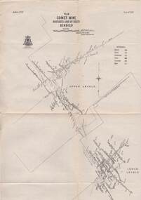
Map - STRUGNELL COLLECTION: HUSTLER'S LINE OF REEFS, BENDIGO, September 1913
Map, Hustler's Line of Reefs, Comet Mine, Bendigo Plan.Plate No.XX1V (24). Map, Bulletin No 33 Signed H.A.Whitelaw Underground survey Office Bendigo September 1913 Drawing shows upper and lower levels and appears to show samples of connecting horizontal shafts with their respective mineral contentsUnderground Survey Office, Bendigo.map, bendigo, comet mine -
 Federation University Historical Collection
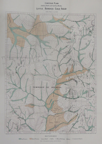
Map - Report, H.S. Whitelaw, Report on the Little Bendigo or Nerrina Gold-Field, Ballarat, 1901, 1901
Blue soft covered book. Includes Contour plan of the Little Bendigo Goldfieldlittle bendigo, nerrena, nerrina, h.s. whitelaw -
Bendigo Historical Society Inc.
Map - WESTON, 21/10/1876
Map: Re-Survey of part of the parish of Weston, County of Rodney. Parish plan (number 309 in map cupboard 1)Murray and Hargreave, Authorised surveyorsmap, rodney, parish plan, parish of weston, murray and hargreave -
Bendigo Historical Society Inc.
Map - TANDARRA : COUNTY OF BENDIGO, 14-3-24
Map. Tandarra, County of Bendigo, Talambe, Yallook, Neilborough, Whirrakee, Kamarooka. Myers Creek, Tandarra Estate. Photo-Lithographed at the Department of Lands and Survey, Melbourne by W.J. Butson, 14-3-24. Price 1/-. By authority Albert J. Mullett, Government Printer, Melbourne. (number 25 in map cupboard 1)Albert J. Mullett, Government Printer, Melbourne.map, bendigo, tandarra -
Lakes Entrance Historical Society
Map - Township of Cunninghame
Map of the Parish of Colquhoun County of Tambo backed on material. 3 pagestownship, waterways, local government -
Whitehorse Historical Society Inc.
Map, Railway map of Victoria, 1912
Detailed map of railways in Victoria including adjacent areas of New South Wales.Detailed map of railways in Victoria including adjacent areas of New South Wales. Also shows 'principal coach routes'. On verso map of suburban lines with eastern line as far as Croydon and Bayswater. key numbers on map linked to pages of a timetable.Detailed map of railways in Victoria including adjacent areas of New South Wales.maps, railways -
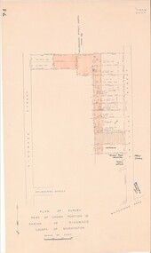
Stawell Historical Society Inc
Map, Bolangum, County of Kara Kara, 1957
Bolangum, County of Kara Karastawell -
 Ringwood and District Historical Society
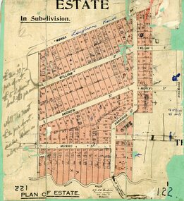
Map, Subdivision Plan, Loughnans Road, Ringwood - circa 1922
Green card with cut-out map of residential allotments, some marked "sold". "Plan of Estate" includes Wonga Road, Loughnans Road, William Street, Andrew Street, Harrison Street, and Munro Street, Ringwood. (Surrounding area is part of Ringwood Park Estate featured in seperate 1922 auction flyer).Handwritten notations - (northern section) {£2-10/- per foot. £5 deposit bal £1 per month} All the rest £2 per foot, value same as above. Licensed Surveyors - W.J. & A.W. Kenhardt, 352 Collins Street, Melbourne. -
 Bendigo Historical Society Inc.
Map - HUSTLER'S REEF & HUSTLER'S REEF NO 1 MINES - PLAN OF THE HUSTLER'S REEF & HUSTLER'S REEF NO 1 MINES
Plan of the Hustler's Reef & Hustler's Reef No 1 Mines on the Hustler's Line of Reefs Bulletin No 33, Plate No XVII. Two drawings with different levels on each for clarity. Shows depth and some geographical features. Geological Survey of Victoria emblem. Signed by H A Whitelaw Underground Survey Office Bendigo, September 1913. mining, parish map, hustler's reef & hustler's reef no 1 mines, hustler's line of reefs, geological survey of victoria, underground survey office bendigo, h a whitelaw -
Whitehorse Historical Society Inc.
Map, Nunawading, 1972
Variation of original 1864 map with a number of additions and bold marking of an area including Forest Hill, Vermont and Vermont South as 'Proclaimed survey area No 21 May 1972 2826. Marked as P M Noting Melb SeriesVariation of original 1864 map with a number of additions and bold marking of an area including Forest Hill, Vermont and Vermont South as 'Proclaimed survey area No 21 May 1972 2826. Marked as P M Noting Melb Series.Variation of original 1864 map with a number of additions and bold marking of an area including Forest Hill, Vermont and Vermont South as 'Proclaimed survey area No 21 May 1972 2826. Marked as P M Noting Melb Seriesmaps, shire of blackburn and mitcham, forest hill, vermont, vermont south -
 Federation University Historical Collection
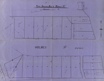
Map, Plan subdivision: Allotment 12 Holmes Street, Ballarat
The Allotments drawn in Holmes Street appear to be hand drawn and showing one of the first subdivisions in Ballarat. This was begun in the 1860s. Some names are marked on the blocks - Taylor (9), Holmes (6), Robert Watson (3), Watson (16), Walter (18),Wetherly (11), Vacant (7)Blue paper with black ink showing the land blocks either side of Holmes Street Each block is numbered - 20 in all Names on some blocksNorth indicated with arrow Sizes of blocks - depth and width holmes street, subdivision, allotment 12, holmes, taylor, robert watson, watson, wetherly, vacant -
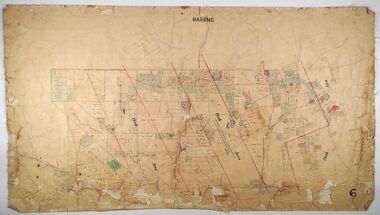 Bendigo Historical Society Inc.
Map - MARONG, Circa 1871
Map; Marong, Hand Draughted parish planmap, bendigo, parish plan, marong -
Lakes Entrance Historical Society
Map - Tildesley West Sheet 2, A C Brooks Gov. Printer, 1965
Map shows North Arm Lake Tyers, Colquhoun East land owners.land owners, waterways, settlement -
University of Melbourne, Burnley Campus Archives
Map - Photocopy, University of Melbourne, c. 1999
Photocopy of enlargement of part of Map 2B, University of Melbourne, Parkville Campus, from Melway Street Directory. On part of page showing Brighton, Hampton, Sandringham, etc.university of melbourne, parkville campus, brighton, hampton, sandringham, melbourne -
 Bacchus Marsh & District Historical Society
Map, Bacchus Marsh Region Parish Plans: Folded set of maps
Set of Victorian Lands Department Parish Plans covering the township of Bacchus Marsh and surrounding districts. Folded. BMDHS Location: AR/SU27/D2: Map Drawersmaps bacchus marsh region, bacchus marsh victoria maps, interim record -
Glen Eira Historical Society
Map - Brady’s Stables, Elsternwick
Hand drawn map and plan (250mm x 200mm) of Brady’s Stables, Elsternwick, undated and unattributed. The file also includes a brief handwritten research note by Peta Darke dated 09/08/2011.brady’s stables, elsternwick, glenhuntly road, glen huntly road, brighton road, elsternwick railway station, nepean highway, stables -
 Federation University Historical Collection
Map, Melbourne, Victoria, 1933
Printed colour map.melbourne, port phillip bay, werribee river, werribee, port melbourne, hobson's bay -
 Melbourne Tram Museum
Map, Metlink, Melbourne's Public Transport Map", 1/2006
Map titled Melbourne's Public Transport Map" published by Metlink 2006, giving details of tram and bus routes, an overall map of Melbourne showing public transport services, premium stations, general information including Metcard information and ticket types. See item 8797 for a 2005 version. Yields information Melbourne's public transport network.Map - full colour with card covers, 8 x 5 fold. tramways, maps, railways, buses, metlink, metcard, public transport -
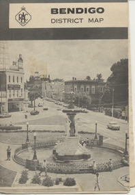 Ballarat Tramway Museum
Map, Royal Automobile Club of Victoria, "Bendigo District Map - RACV", c1971
Printed street map titled "Bendigo District Map", published by the RACV, showing the central part of Bendigo, Bendigo Outlets, streets, principal attractions, Bendigo and district maps and information, and a list of sporting and entertainment facilities. Has the tram lines shown dotted, only shows the full extent of the Golden Square line. The main map has the number "0171" in the bottom left hand corner, indicating the publication date.in ink on the Bendigo Outlet map, "3/4" along bottom edge.trams, tramways, map, bendigo, racv, railways -
Whitehorse Historical Society Inc.
Map, Aboriginal sites in the City of Doncaster-Templestowe, 1/03/1991 12:00:00 AM
Map of City of Doncaster and Templestowe.Map of City of Doncaster and Templestowe showing location of stone artefacts and scarred trees.Map of City of Doncaster and Templestowe. aborigines, city of doncaster and templestowe -
University of Melbourne, Burnley Campus Archives
Map (item) - Geological map, Geological map of Melbourne & suburbs. Issued by the Department of Mines, Victoria, 1937
-
Port Melbourne Historical & Preservation Society
Map, John Millar, "Design for Ship Canal or 'tidal harbor' and docks for the Port of Melbourne", 21 Sep 1860
COPYRIGHT STATE OF VICTORIA Hydrographic map. "Design for Ship Canal or 'tidal harbor' and docks for the Port of Melbourne". Shows proposed extension of the city westward. Signed 21.09.1860, lithographed 21.12.1860 and reproduced 1986transport - shipping, piers and wharves, engineering - canals and drainage, town planning -
 Ringwood and District Historical Society
Map - Plan of Survey, Part of Crown Portion 12, Parish of Ringwood, Victoria - circa 1930
Map of area bounded by Ringwood Street, Melbourne Street and Adelaide Street, showing details of Adelaide Street allotments and existing outbuildings. Certificate of Title numbers include Ringwood Street C/T 3418-553, C/T 3563-433, Adelaide Street C/T 7151-047, C/T 7038-465, C/T 7098-464, C/T 7098-465, C/T 3604-635, C/T 8066-900, C/T 3866-118, C/T 3609-728, and C/T Vol 3670 Fol 133992.Subsequent additional notations identifying 1971 closure of Melbourne Street North, and properties of Hone, Patendon, Pines Hosptial, Mail Office, Presbyterian Church and Falconers Grocery Shop on Whitehorse Road corner. -
Lakes Entrance Historical Society
Map - Colquhoun
Map of Colquhoun showing landowners Lake Tyers and Lakes Entrancemaps, townships, landowners -
 Bendigo Historical Society Inc.
Map - JACK FLYNN COLLECTION: TARNAGULLA SHEET 4, 25/11/1926
Map: Parish of Tarnagulla Sheet 4, Counties of Gladstone and Bendigo. Parish plan.Photo-Lithographed at the Department of lands and Survey, Melbourne by W. J. Butson. 25.11.26map, gladstone, parish plan, tarnagulla sheet 4