Showing 2372 items in the category Documentation with item type Map
-
 Stawell Historical Society Inc
Map, Illawarra, County of Borung, 1882
Illawarra, County of Borungstawell -
 Bendigo Historical Society Inc.
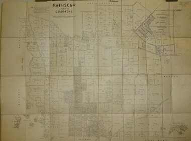
Map - JACK FLYNN COLLECTION: RATHSCAR, 14/09/1935
Map: Parish of Rathscar, County of Gladstone. Parish plan.map, gladstone, parish plan, rathscar -
 Bendigo Historical Society Inc.
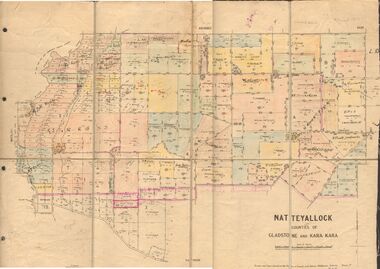
Map - JACK FLYNN COLLECTION: NATTE YALLOCK, 22/06/1937
Map: Parish of Natte Yallock, Counties of Gladstone and Kara Kara. Parish plan.By Authority H.J. Green Government Printer Melbourne. Drawn and Reproduced at the Depart., of Lands and Survey, Melbourne, Victoria.map, gladstone, parish plan, natte yallock -
 Federation University Historical Collection
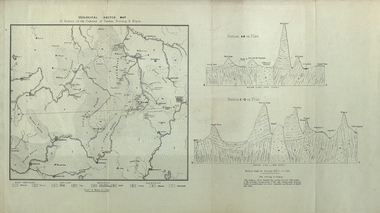
Map, Geological Sketch Map of of Dundas, Berung, and Ripon Counties
Map of the Counties of Dundas, Berung, and Riponcounty of dundas, county of berung, county of ripon, map, geology, ararat, stawell, hamilton, grampians -
Bendigo Historical Society Inc.
Map - BEAR'S LAGOON, 2/10/1931
Map: Town of Munica ( name crossed out and Bear's Lagoon hand written in), Parish of Janiember east, County of Bendigo ( number 151 in Map Cupboard 1)map, bendigo, township, bear's lagoon, munica, janiember east, county of bendigo -
 Bendigo Historical Society Inc.
Map - CAMPBELL COLLECTION: BENDIGO AND DISTRICT MAPS
Map. Bendigo & District. The same as 10104.1. The map is in a very damaged condition.map, bendigo, allotments -
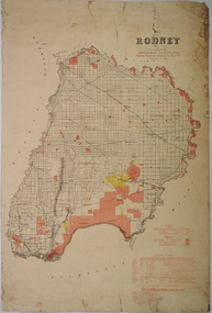 Bendigo Historical Society Inc.
Map - COUNTY OF RODNEY, No date visible
Map: Plan of the whole County of Rodney , showing areas available for selection, October 1st 1893.map, rodney, areas available for slection, county of rodney -
Bendigo Historical Society Inc.
Map - CAMPBELL COLLECTION: BENDIGO & DISTRICT MAPS
Map. Bendigo Whipstick, Scale 40 chains to 1 inch, Forests Commission Victoria, map N0.3, legend for roads and land and forest. (number 371 in map cupboard 1)map, bendigo, country lands -
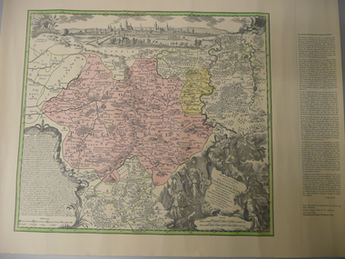 Bendigo Historical Society Inc.
Map - STRAUCH COLLECTION: MAP EPISCOPATUS PADERBORNENSIS
Coloured map of Paderborn Germany, Presented to the German Heritage Society, Bendigo on 17.1.1995 by the most Reverend J.J.Degenhardt D.D.Archbishop of Paderborn on his visit to Bendigo with the Reverend Monsignor B.Kresing. Vicar-General, Paderborn and Rev. Father M.Reitemeier. (Chaplain)map, maps-germany-paderborn-german heritage society -
 Ballarat Tramway Museum
Map, Ken McCarthy, Map of Proposed National Park Line - SPER, mid 1950's
Hand drawn plan on plain foolscap paper of proposed tram line from Loftus to View Point within National Park for South Pacific Electric Railways - with notes, proposed destination roll.trams, tramways, sper, national park line, loftus, destination roll -
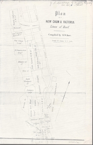 Bendigo Historical Society Inc.
Map - NEW CHUM & VICTORIA LINES OF REEF - PLAN OF NEW CHUM & VICTORIA LINES OF REEF
Two pages of a Plan of New Chum & Victoria Lines of Reef, compiled by G. W. Hart. Taken from J. N. Macartney's G'Fields Registry for 1871. Plan shows leases from High Street to California Gully. Location of the Manchester Arms, British & American Hotel and the Quartz Miners Arms are shown. Townships of Long Gully and Ironbark are shown.map, goldfields, new chum & victoria lines of reef, victoria catharine g m coy, thornton & co, extd victoria reef g m co, ural tribute compy, nil desperandum compy, koch, north victoria g m co, danger hill coy, north endeavour coy, wheadon & co, pilot co, north energetic co, energetic compy, endeavour company, hercules co, victoria gold mines compy, iron duke g m co, golden fleece united, ballerstedt, alfred co, confidence co, prince alfred co, canterbury co, advance co, wells, humboldt co, adventure co, try me well, sterry & co, gibbs & ballerstedt, handy andy, wells?, south adventure co, w rae, victoria reef quartz m co, myra co, jackson, wybrants, burrows & sterry, new chum & victoria tribute, old chum co, ballerstedt, lazarus, watson, koch & hildebrand, lansell & hunt, dennis, abe lincoln co, bonati & co, ellesmere co, moore late menzies, british co, british tribute co, garibaldi, c c co, new chum trib, dobson & co, young chum co, little chum co, old chum co, new chum trib, little chum trib, g w hart, j n macartney's g'fields registry for 1871, manchester arms, british & american, quartz miners arms -
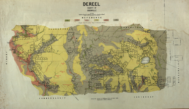 Federation University Historical Collection
Map, Dereel, County of Grenville, 1890, 1890
Dereel is in western Victoria.Geological map of Dereel in the County of Grenville featuing six colours (predominantly grey and yellow). WGS 84 Centroid Lat: 37 degrees 48 feet 50 inches S Long:143 degrees 42 feet 10 inches S N-S: 6.4 km E-W: 15.2 km dereel, ferdinand krause, crown lands department, plan -
Glen Eira Historical Society
Map - Gardenvale Road, 11, Caulfield South
A one page typed letter from Equity Trustees to S P Simmonds Estate Agent, dated 12/12/1963, requesting a valuation of the property at 11 Gardenvale Road, Caulfield South. The file also includes a three page typed valuation of the property dated 19/12/1963. It provides details of the property and includes a hand drawn plan (75mm x 100mm) showing measurements of the block. The file also includes one page of undated, unattributed, handwritten working notes for the purpose of the valuation.redapple r r, redapple joseph, redapple rebecca rachel, gardenvale road, caulfield south, land values, brick houses -
Whitehorse Historical Society Inc.
Map, Canterbury Road, Vermont, c1970
Enlarged aerial photo of intersection of Canterbury and Boronia Roads. State Aerial Survey, Melbourne 1970 project.Enlarged aerial photo of intersection of Canterbury and Boronia Roads. State Aerial Survey, Melbourne 1970 project.Enlarged aerial photo of intersection of Canterbury and Boronia Roads. State Aerial Survey, Melbourne 1970 project.canterbury road, vermont, boronia road, vermont, mitcham road, vermont, frances avenue, vermont, nurlendi road, vermont, webb court, vermont, vermont primary school, no. 1022, aerial photographs -
Lakes Entrance Historical Society
Map - Plan of Township of Lakes Entrance
Plan of township of Lakes Entrance showing waterways and land ownerstownship, waterways, maps -
Bendigo Historical Society Inc.
Map - CAMPBELL COLLECTION: BENDIGO AND DISTRICT MAPS, 15-2-29
Map. Nerring, Parish of Nerring, scale 20 chains to 1 inch. Prepared in W.J.B. from A and B plans by W.J. Galbraith 15-2-29. (number 356 in map cupboard 1)W.J.Galbraithmap, bendigo, parish plan -
Bendigo Historical Society Inc.
Map - PARISHES OF CORNELLA AND TOOLLEEN, Circa 1880
Map: Parishes of Cornella and Toolleen, Compilation of 2 hand draughted parish plans applied to vanvas backing. Originally in Map Cupboard. Relocated to Map Drawer 5 on 5.22.9.22. Too long for the map cupboard.map, parish plan, cornella , toolleen -
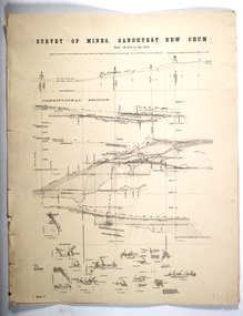 Bendigo Historical Society Inc.
Map - SURVEY OF MINES, SANDHURST, NEW CHUM, Circa 1881
Map: Survey of Mines, Sandhurst, New Chum, Longtitudinal Section of the New Chum, reef. 2 sheets. Sheet 5 and Sheet 8map, mining plan, survey of mines , sandhurst, new chum, gold mines bendigo -
Whitehorse Historical Society Inc.
Map, Shire of Blackburn and Mitcham, c1920
Hand drawn map of the Shire of Blackburn and MitchamHand drawn map of the Shire of Blackburn and Mitcham (Sheet 2) Scale 4 chains = 1 inchHand drawn map of the Shire of Blackburn and Mitchamshire of blackburn and mitcham, tunstall, nunawading, mitcham, maps -
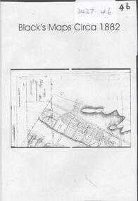 Bendigo Historical Society Inc.
Map - BLACK'S MAPS CIRCA 1882, 1882
DVD. Black's maps Circa 1882. -
 Ringwood and District Historical Society
Map, Proposed Subdivision - Hilltop Estate, Heathmont, Victoria - circa 1925
Plan of Part of Crown Allotments 16 & 18, Parish of Ringwood, County of Mornington. Subdivision includes Site for Heathmont Station, Heathmont Road, George Street, Lilian Street, Edith Street, Edna Street, Great Ryrie Street. Inset locality plan also shows nearby Electric Railway Estate and Heathmont Station Estate. L.H. Webber, Licensed Surveyor, 440 Little Collins Street, Melbourne. -
 National Vietnam Veterans Museum (NVVM)
Map
Highly detailed map of Vietnam on parchment from Fwouc Tho Province. Map is waterproof.map, peter lewis -
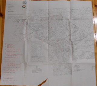
 Bendigo Military Museum
Map - TRENCH MAP, FRANCE WW1, 1918
Areas covered on this map, “Ribemont, Morlancourt, Dernacourt, Fricourt, Mericourt, Saily Le Sec” Item re William Alexander No 502 AIF. Refer Cat No 3746.3 for his service details.Trench map, France, Edition 2 E, sheet 62D N.E, scale 1:20,000, trenches corrected to 28.5.1918, German trenches in red, British in blue.map, france, trench -
Stawell Historical Society Inc
Map, Special Allotments, Reefs, Pleasant Creek
Special Allotments, Reefs, Pleasant Creekstawell -
Port Melbourne Historical & Preservation Society
Map - City of Port Melbourne, Department of Lands and Survey, 29 Nov 1938
Printed map of City of Port Melbourne - Fishermens Bend area and down to Williamstown Road (Kitchens etc). 1938Red pencil marks through existing Lorimer St (refer 306)built environment - industrial, health - general health, fishermans bend, j kitchen & sons pty ltd -
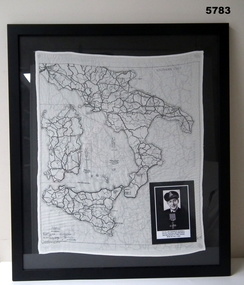 Bendigo Military Museum
Map - MAP, ITALY, SILK, 1939 - 45
The silk maps were carried by Aircrew. This item carried by A.F. Goodall DFC, RAAF, refer Cat No 543.2 for his service details.Framed silk map of Italy and Sicily, black frame with black backing, map is in all black, the other side shows Northern Italy, inset is a photo of A.F. Goodall DFC, RAAF.silk, maps -
University of Melbourne, Burnley Campus Archives
Map, Melbourne and Metropolitan Board of Works Plan No. 42 Richmond, c.1884-1891
Photocopy of Melbourne and Metropolitan Board of Works Plan No 42 M 387 ₍₄₂₎ of Richmond from plans dated c1884-1891. Shows A. Lynch's Plan of the Gardens. Scale 160 ft. to 1 inchOriginal stamped "Original Plan Room"melbourne and metropolitan board of works, richmond, burnley gardens, richmond park -
 Wodonga & District Historical Society Inc
Map - Boorgunyah - "The Town that never was"
At the height of the river trade, there was a town surveyed and laid out, and streets were named. This town was to house the workers at the river port of Red Bank when the paddle steamers plied the Murray River as far as Albury, carrying produce such as wool and wheat to the various towns along the river in the 1800s. As the river trade died away, this town never went ahead – one might say, “The town that never was.” A lone gum tree stands on the site today.This item is significant because it documents plans which were made for the early development of Wodonga.A black an white map depicting the proposed location of the township. The map is based on a sketch and is not to scale,early wodonga, boorgunyah - "the town that never was", wodonga heritage -
 Bendigo Historical Society Inc.
Map - BENDIGO HISTORICAL SOCIETY COLLECTION: EAGLEHAWK MINE MAP
Base map Australian map grid of Eaglehawk area. Map has letter attached from the Department of Conservation, Forests and Lands, 22 March, 1990, addressed to Felicity Kingerlie, BHS, requesting information regarding the historic mining sites marked on the map. Sites marked are: A. Golden Age Mine, engine mountings present B. Johnson's No. 2 Mine, engine mountings, old boiler foundations C. Johnson's No. 1 Mine, mullock retaining wall made from sandstone, engine mountings, remains of old building demolished? D. Toma's Eucalyptus Factory, old boiler still there, boiler shed, chimney (remnants of) outlet drain, distilling vats, dam, remnant of winch. E. New Argus Mine,mullock heap F. New Moon Mines Dams (1) stone walls G. North Lightning Hill Mine, engine mountings, quartz retainer wall, Pascoe and Simmons open cuts and other open cuts here too H. New Prince of Wales Mine and Poppet Head I. Quarry site for stone, excavation (for miners cottages in Clarke Street) J. Lancashire open cut mine K. Virginia Hill (cynaide vats etc) L. South Prince of Wales mine, now capped and fenced M (possibly ) Catherine United Mine, engine mountings, battery mountings?bendigo, mining, eaglehawk mines -
Bendigo Historical Society Inc.
Map - NOLAN, COUNTY OF BENDOGO, 7-5-30
Map, Nolan, County of Bendigo, Egerton; Elmore; Goornong. Campaspe River, Elmore Estate, By Authority: H.J.Green, Government Printer,Melbourne.Price 2/-.Drawn and Reproduced at the Dept. of Lands and Survey,Melbourne,Victoria.7-5-30. (number 1 in map cupboard 1)H.J.Green,Government Printermap, bendigo, nolan