Showing 2195 items
matching documentation
-
 Bacchus Marsh & District Historical Society
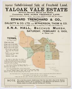
Map, Edward Trenchard & Co, Important Subdivisional Sale of Freehold Land Yaloak Vale Estate
A land sales map and advertisementLand sales advertising poster with map indicating specific lots of land for sale.A land sales map and advertisementimportant subdivisional sale of freehold land yaloak vale estate, land sales -
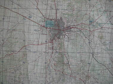
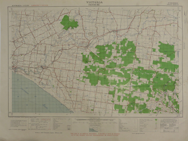
 Moorabbin Air Museum
Map (item) - Koolymilka South Australia Sheet 6239-111 Edition 1 Series R742- Woomera Evatts Field, Koolymilka South Australia Sheet 6239-111 Edition 1 Series R742 - Woomera Evatts Field
-
 Federation University Historical Collection
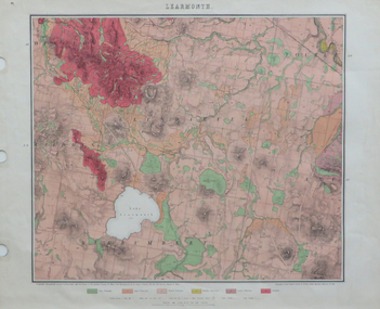
Map, Geological Map of Learmonth, 1882, 10/1882
Two copies: (printed noted attached) 3.) Rectangular geological map edged in masking tape. Six colours define geology and are predominantly pink. Scale 40 chains to one inch .4) Notes referring to the Geological Map of Learmonth learmonth, lake learmonth, glendaruel, burrumbeet, mt blowhard, morton's hill, mt bolan, addington, mt cavern, coghill's hill, mt hollowback, mt pisgah, weatherboard hill, webster's hill, foster's hill, mt bolen, one mile hill, vaughan's hill, tourello stattion, ballarat to maryborough railway, saddleback hill, ceres, brown's hill, ross's hill, norman taylor, robert burrows, richard shephard, james finnie -
 Bendigo Historical Society Inc.
Map - LONG GULLY HISTORY GROUP COLLECTION: MAP - EAGLEHAWK ROAD
BHS CollectionMap of part of Eaglehawk Road showing a Bike Ride Trail. Map is dated September 01, 1998, Scale 1:5000.bendigo, history, long gully history group, the long gully history group - map - eaglehawk road, natural resources and environment, bike ride trail -
Bendigo Historical Society Inc.
Map - NERRING : COUNTY OF BENDIGO, August 1952
Map. Nerring, County Of Bendigo. Yarraberb, Neilborough, Huntly, Sandhurst, Leichardt, Marong. Drawn and reproduced at the Department of Lands and Survey, Melbourne,Victoria. August 1952, Price 2/-. By Appointment J.J. Gourley, Government Printer, Melbourne. (number 0 in map cupboard 1)J.J. Gourley,Government Printermap, bendigo, nerring -
 Ballarat Tramway Museum
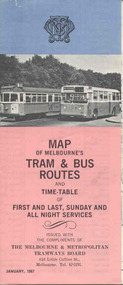
Map, Survey and Mapping for MMTB, "Map of Melbourne's Trams and Bus routes and all night services", Jan. 1967
Fold out sheet coloured map, 12 portions or folds, - title - "Map of Melbourne's Trams and Bus routes and all night services" map shows trams lines, route numbers, terminal points, bus routes, railway lines, blow up of city area with places of interest and key. On rear details, places of interest, suburb index, index to routes, first and last services, Sunday am services, all night bus services and locations of depots and head office. 2nd copy added 11-8-2006. Images of document - scanned to A3 size and overlapping added 30/10/13 On rear "out of date" stamp and 1 "cancelled" stamp - red ink.trams, tramways, melbourne, map, tram & bus services, all night services -
Bendigo Historical Society Inc.
Map - CITY OF BENDIGO STREET AND ROAD MAP, 1946
Map: City of Bendigo Street and road map, Incorporating the Borough of Eaglehawk and surrounding Districts. Compiled by W.C Harrymap, bendigo, city streets, bendigo streets -
Bendigo Historical Society Inc.
Map - CROSBIE, 26/09/1878
Map: Crosbie, County of Rodney. Parish plan (number 260 in map cupboard 1)map, rodney, parish plan, crosbie, county of rodney -
Whitehorse Historical Society Inc.
Map, Sketch plan of Box Hill Cemetery, c1980
Sketch plan of Box Hill Cemeterybox hill cemetery -
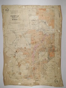 Bendigo Historical Society Inc.
Map - HUNTLY, 16/11/1903
Map: Huntly, County of Bendigo. Parish plan. Drawn by Bartholomew Becket, examined by W S Stephen 15/3/80, examined by J Walshe Sept 1903, additions H Hansford August 1903map, bendigo, parish plan, bartholomew becket, w s stephen, j walshe, h hansford, huntly -
 Bacchus Marsh & District Historical Society
Map, Lerderderg District Proposed Irrigation and Water Supply Trust (B) Plan Showing Proposed Works
The 1886 Irrigation Act in Victoria introduced the first legislation in Australia designed to enable the creation of a detailed scheme for agricultural irrigation. Part of the legislation saw the use of government funds for local irrigation projects. These local projects were managed by local irrigation trusts. The Lerderderg Irrigation and Water Supply Trust was formed in 1890. This map depicts the proposed area of the Trust and proposed works such as channels and weirs.Printed paper map of the proposed Lerderderg District Irrigation and Water Supply area showing proposed works. The map scale is 40 chains + 1 inch. The Lerderderg District lies within the Parishes of Korkuperrumul and Merrimu in the County of Bourke. At the top of the map above its title is the letter 'B; in capital lettering. A series of proposed channels are indicated on the map in red lines. A proposed weir site and alternative weir site are also indicated on the map. irrigation, water supply, lerderderg irrigation and water supply trust -
 Peterborough History Group
Map - Map of Peterborough House 1921, 1921
This hand drawn map of the buildings and out buildings was done for insurance purposes. It indicates which buildings are covered and which are uninsured. Significant as it shows a plan of the hotel as it was in 1921. Each building is labelled by its purpose, which provides an interesting insight into holidays of the time. For example, 'sleep outs' and external bathrooms. A4 photocopy of a hand drawn map of the buildings and out buildings comprising Peterborough House. Hand drawn map -
Canterbury History Group
Map - Camberwell and Boroondara, Melbourne and Metropolitan Board of Works, c.1905
Copy of Melbourne and Metropolitan Board of Works Plan no. 71 for Camberwell and Boroondaracanterbury, maps, melbourne and metropolitan board of works -
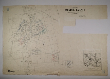 Bendigo Historical Society Inc.
Map - MEMSIE ESTATE, 26/08/1905
Map:Plan of Memsie estate, aquired under Closer Settlement Act 1904. Parish plan. Map dated 26/08/1905.map, estate, memsie estate, closer settlement act 1904. -
Bendigo Historical Society Inc.
Map - PARISH OF MARONG, 24/09/1874
Map; Parish of Marong ,County of Bendigo. This plan has been cut and then applied to a different backing. ( number 234 in Map Cupboard 1)map, bendigo, parish plan, marong -
Port Melbourne Historical & Preservation Society
Map - Melbourne and suburbs, MMBW, 8 Dec 1909
MMBW map of Melbourne and suburbs - Record plan up to July 1st 1913 (scale 3/4" = 1 mile)engineering - board of works, calder e oliver, russwaul(?) -
Bendigo Historical Society Inc.
Map - SANDHURST SHEET 6, 1947
Map: Sandhurst sheet 6. Parish plan ( number 196 in Map Cupboard 1)map, bendigo, city streets, sandhurst -
Bendigo Historical Society Inc.
Map - STRATHFIELDSAYE, 25/06/1877
Map: Strathfieldsaye, County of Bendigo. Parish plan (number 291 in map cupboard 1)map, bendigo, parish plan, strathfieldsaye -
Port Melbourne Historical & Preservation Society
Map - West and North Melbourne, MMBW, 21 Feb 1936
Melbourne and Metropolitan Board of Works plan No 24 of West and North Melbourne Docklands,1936signed A.W. Walkermmbw, melbourne and metropolitan board of works, a w walker -
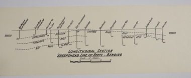 Bendigo Historical Society Inc.
Map - SHEEPSHEAD LINE OF REEF, Circa 1940's
Map: Plan showing a Longitudinal section of the Sheepshead line of Reefs , Bendigo. (34 Copies)map, bendigo, mining plan, sheepshead line of reef, gold mines , mining -
 Federation University Historical Collection
Map, Ballarat, 1936, 06/1936
Map of Ballarat and surrounds, including Lake Learmonth, Snake Valley, Linton, Newton, Durham Lead, Sebastopol, Lake Wendouree, Winter Swamo. It was surveyed in 1933.ballarat, map -
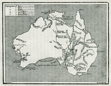 Ballarat Heritage Services
Map, Exploration of Eyre, Sturt, Stuart, Gregory, Burke, and Wills
Copy of a map from 'A Short History of Australia' by Ernest Scott.map, explorers, exploration, burke and wills, sturt, stuart, gregory, melbourne, perth, sydney, mitchell river, a.c. gregory, darling river, lachlan river, mt stuart, murray river -
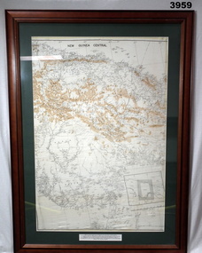 Bendigo Military Museum
Map - MAP, NEW GUINEA FRAMED, C. 1941 onwards
Map of central section of New Guinea. Black print on white background with mountain ridges in tan. Map is mounted with green border. Brown wooden frame, glass front, white cardboard backing with wire hanging strap on back. Map prepared under the direction of RAAF Headquarters.Printed in black top centre: “NEW GUINEA CENTRAL” Printed on border under map: “These escape maps were carried in the zip pocket of life jackets by fighter pilots in WW2. This map was presented to A.S.R. on 12.7.79 by Councillor Ian McKenzie, Mayor of Eaglehawk, who served as a fighter pilot in 78th SDN in the SW Pacific area during 1943-44.”map, new guinea, central, raaf -
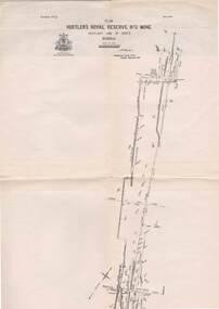 Bendigo Historical Society Inc.
Map - STRUGNELL COLLECTION: HUSTLER'S LINE OF REEFS, BENDIGO, September 1913
Map, Hustler's Line of Reefs, Hustler's Royal Reserve No.2 Mine, Bendigo Plan. Plate No.V1 (6). Bulletin No 33 Signed H.A.Whitelaw Underground survey Office Bendigo September 1913Underground Survey Office, Bendigo.map, bendigo, hustler's royal reserve no. 2 mine* -
Whitehorse Historical Society Inc.
Map - WW1 Trench map, Belgium collected by C H Honybun, Belgium WW1 map Edition 3, Nov 1917
WW1 map of Belgium Edition 3 Sheet 28 S.W. and S.E. Trenches in rednon-fictionWW1 map of Belgium Edition 3 Sheet 28 S.W. and S.E. Trenches in redworld war 1914 - 1918, maps -
 Bacchus Marsh & District Historical Society
Map, Bullengarook Parish, County of Bourke
An undated parish plan map for the parish of Bullegarook. This parish area is close to the Bacchus Marsh district and borders some of the areas contained within the former Bacchus Marsh Shire and present day Moorabool Shire.A single page paper map showing the parish plan map for Bullengarook. This parish area contains the locality of Bullengarook and parts of the Wombat State Forest and is close to the town of Gisborne. A cadastral map showing land ownership. The map is not dated but a very similar map held by the State Library of Victoria is estimated to date from about 1927. The map is pasted into a bound volume containing 76 maps or plans in total. High resolution digital image stored on BMDHS computer network. bullengarook parish maps -
Whitehorse Historical Society Inc.
Map, State Electoral Districts, 1937
Map showing [Victorian] State Electoral Districts, Metropolitan, 1937.Map showing [Victorian] State Electoral Districts, Metropolitan, 1937. Scale: 40 chains to the inch.Map showing [Victorian] State Electoral Districts, Metropolitan, 1937.electoral boundaries, melbourne, elections -
 Federation University Historical Collection
Map, Panmure, 1942, 1942
Printed colour map on paperpanmure, garvoc, curdie, allansford, bushfield, hopkins river -
Bendigo Historical Society Inc.
Map - POMPAPIEL : COUNTY OF BENDIGO, 1-10-27
Map. Pompapiel, County of Bendigo, Calivil, Talambe, Yallook, Salisbury, Yarrayne, Janiember East, Waranga Mallee Channel, Blind Creek, Judyong Creek, Bullock Creek. Photo-Lithographed at the Dept. of Lands and Survey Melbourne by W.J. Butson 1-10-27. Price 1/-. (number 85 in map cupboard 1)W.J. Butsonmap, bendigo, pompapiel -
Whitehorse Historical Society Inc.
Map, Proposed suburb names, 1999
Whitehorse City Council: proposed suburb names and boundaries. Version 3.1Whitehorse City Council: proposed suburb names and boundaries. Version 3.1Whitehorse City Council: proposed suburb names and boundaries. Version 3.1city of whitehorse, suburb names