Showing 2247 items in the category Documentation with item type Map
-
 Bendigo Historical Society Inc.
Map - NERRING SHEET 4, Circa 1890's
Map: Nerring (part 4) . Parish plan ( number 189 in Map Cupboard 1)map, bendigo, parish plan, nerring -
 Bendigo Military Museum
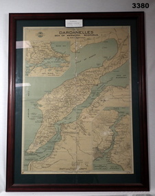
Map - MAP GALLIPOLI, FRAMED, H E C Robinson, Post WW1
Brown wooden frame with glass front. Coloured map of Dardanelles featuring the Sea of Marmara & The Bosporus. Mounted on green background with fawn cardboard backing. Map in scale of miles & kilometers. Map shows landings, ships sunk & events during 1915.Back of frame: “Bethany Gallery 116 Bridge Street Bendigo”map, framed, dardenelles, gallipoli, 1915 -
Whitehorse Historical Society Inc.
Map, Proposed layout at car park for Mitcham RSL, 14/12/1972
Plan of car park for proposed Mitcham RSL, McDowall Street, Mitcham.Plan of car park for proposed Mitcham RSL, McDowall Street, Mitcham. Architect: L.R.Saward. Amended 19 Feb.1973. Approved by Nunawading Council 16 Mar 1973.Plan of car park for proposed Mitcham RSL, McDowall Street, Mitcham. mitcham returned servicemens league, mcdowall street mitcham -
Bendigo Historical Society Inc.
Map - REDESDALE : COUNTY OF BENDIGO, 25 -10-77
Map. Redesdale, County of Bendigo, County of Dalhousie, County Of Talbot, Lyell, Kimbolton, Langwornor, Spring Plains, Glenhope, Emberton, Metcalfe, Hawkestone, River Coliban, Campaspe River, Back Creek. Photo-Lithographed at the Department of Lands and Survey, Melbourne by J. Noune, 25-10-77. Compared with original plans 12-11-78 M. Kemp. J.C.Kelsh, Draughtsman April 1876. Examined by E. Downward, 5-6-77. (number 121 in map cupboard 1)J. Nounemap, bendigo, redesdale -
Bendigo Historical Society Inc.
Map - YARRABERB : COUNTY OF BENDIGO, 23-2-15
Map. Yarraberb, County of Bendigo, Salisbury, Yallook, Neilborough, Nerring, Leichardt, Bridgewater. L5373. Photographed at the Department of Lands and Survey, Melbourne by W.J. Butson 23-2-15. Price 1/-.By authority: Albert J. Mullett, Government Printer, Melbourne. (number 16 in map cupboard 1)By authority Albert J. Mullett, Government Printer.map, bendigo, agricultural lands -
 Ballarat Heritage Services
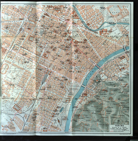
Map, Torino, 1924, 1924
Map of Torino, Italy in 1924italy, map, torino -
 National Vietnam Veterans Museum (NVVM)
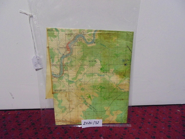
Map
A laminated coloured map of the Son River, Dang Nai, Vietnammap, 3rar, mcphail collection -
 Melton City Libraries
Map, Mount Cottrell Fire group, Unknown
"In 1966, the Mount Cottrell Fire Brigades Group was formed as a way of consolidating the smaller groups around Melton, Rockbank, Toolern Vale, Sydenham, Truganina and Werribee. Its headquarters were established at the home of Ernest ‘Bon’ and Edna Barrie in Ferris Road, Melton. Captain Bon Barrie was a member of the Melton Fire Brigade and elected group and communications officer of the new Mount Cottrell Brigades Group". Fire Brigade Meeting 14th September held at Rockbank Formation a new Group in Region 14 Present: R/O H Rothsay, Assistant R/O R Orchard Tru? G Summerton Purpose of Group The pooling of the equipment in the area should be co-ordinated under one leader. The Brigade and private equipment should be co-ordinated under one leader. Formation was carried unanimously. To be called Mt Cotterill Group. Rockbank nominated Captain E W Barrie elected, Secretary K Watt Toolern Vale. Names listed C/O K L McNaughton Anakie Group COO/O R B Chirnside Lieut J Richmond Capt E Gillespie Toolern Vale Eddie L/ T S Atkin Stan L/T B Storey Bert Sec K Watt Keith Capt E W Barrie Melton Bon L/T K Gillespie Keith A Gillespie Arthur L/T G Lunson George L/T J Robinson Jeff Capt A Marquand Truganina Alan L/T I Cowie Ian Sec T Gard Tom Capt G Harrison Rockbank a/ps G Harrison N Harrison N Fisher a/ps S Hirt Melton Steve Pres M Chomley Sydenham Capt S Hughes Stan Capt L Waterson Werribee Lex Res/o J Hanson G/O S Cooper Bacchus Marsh Syd P/GO W Lidgett Wal Pro/O D Dunton G/O T Healy R C [Mt Macedon] Tom Reg Sec G Douglas Hand written notes of Edna Barrie Typed by Wendy Barrie Maps of the Mt Cottrell Fire groupemergency services, maps -
Beechworth Cemetery Trust
Map - Beechworth Cemetery reproduction of original map, Beechworth Cemetery Reproduction - Treasurer copy
Reproduction map displaying all grave sites in Beechworth Public Cemetery. Rotunda, fountain, nursery, memorial wall, pioneer sectionmap displays the plan of grave sitesLaminated Photocopy of original cemetery map with additional information hand-written on the map. All graves at the cemetery set out in denominational sections with hand-written information on additional graves added to sections in Roman Catholic A & C, Church of England A-F, Presbyterian A-C, Methodist/Uniting B and Wesleyan A. Multidenominational hand-written note on Jews section with Trust Minutes 4.7.'83 written next to this addition. Additions hand-drawn of fountain, memorial wall, nursery and pioneer cemetery.rotunda, fountain, nursery, memorial wall, pioneer section, graves, chinese section, un-numbered grave sites, cemetery -
Moorabbin Air Museum
Map (Item) - Map of Port Melbourne & Coode Island Rifle Range circa 1950s-60s
-
Bendigo Historical Society Inc.
Map - WESTON : COUNTY OF BENDIGO : COUNTY OF RODNEY, 4-5-21
Map. Weston, County of Bendigo, County of Rodney, Muskerry, Crosbie, Knowsley East, Knowsley, Axedale. Back Creek. By authority A.J. Mullett, Government Printer, Melbourne. Photo-Lithographed at the Department of Lands and Survey, Melbourne by W.J. Butson 4-5-21. Price 1/-. (number 108 in map cupboard 1)A.J. Mullett, Government Printer, Melbourne.map, bendigo, weston -
Moorabbin Air Museum
Map (Item) - Middle East Egypt WW1 AFC Map
-
 Bendigo Historical Society Inc.
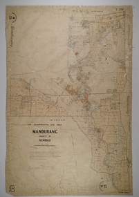
Map - MANDURANG 2, Date unreadable
Map: Mandurang, County of Bendigo. Parish plan Examined by W. S. Stephen 11.12.79 W. E. Porter Draughtsman July 1879map, bendigo, parish plan, mandurang, w.s. stephen, w. e. porter -
 Bacchus Marsh & District Historical Society
Map, Maddingley Township, Parish of Parwan, circa 1890s
Maddingley is a locality or township within the broader township area of Bacchus Marsh. This map is not dated. However features in Maddingley which appeared in the 1880s and 1890s are present in the map, These include the Bacchus Marsh Railway Station and the Bacchus Marsh Showgrounds. The main residential and commercial area of Maddingley is shown on this map in an area bounded by Bacchus Street, Barry Street, Griffith Street and Maddingley Road. Other streets visible are Franklin Street, Inglis Street, Labilliere Street, McCrae Street, Moore Street and part of Station Street.A single page paper map showing land allotments, streets, rivers, creeks, park lands, the railway line and Bacchus Marsh railway station in the township of Maddingley. The map is pasted into a bound volume containing 76 maps or plans in total. bacchus marsh victoria maps, maddingley victoria maps, land use, maddingley victoria history -
 Federation University Historical Collection
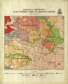
Map, Geological Sketch Map of the Werribee Gorge and Adjacent Country, 1914, 1914
A coloured geological sketch map of the Werribee Gorge, Bacchus Marsh, Rowlesy, Darley, Parwan. The scale is 1 mile to 1 inchwerribee gorge, bacchus marsh, darley, parwan, w.e. bennett, bennett, r.a.f. murray, c.c. brittlebank, rowsley -
 Warrnambool and District Historical Society Inc.
Map - Maps, Soldiers Settlement WW2, Circa 1950
The soldiers' settlement scheme operated after the first and second world wars in an effort to more closely settle the land and also give opportunities to returned soldiers. Crown land and other larger estates were acquired for the purpose. Most of these maps relate to the area north of Warrnambool where many of the subdivisions were parts of larger estates.These maps pertaining to the Soldiers' Settlement program, relate to an interesting part of Australian and local history. As such they have historic and social interest and significance.A collection of 25 paper maps which relate to to the soldiers settlement post World War 2. Some have details of the people allocated the land and some smaller maps have the printed details of the applicants requirements.Text is black on white paper which in some cases is quite aged. The maps are as follows: .1 Narrapumelap Estate ( Ripon & Hampden) .2 Narrapumelap Estate Part 2 (Villers & Ripon) .3 Narrapumelap Estate Part 3 ( Villiers & Ripon) .4 Burrumbeet Estate ( Ripon) .5 ' Berrambool' Estate 9 Hampden & Villiers) .6 ' Hopkins Hill' Estate Villiers 4011 acres .7 Caramut North No 2 Estate ( Villiers ) .8 ' Morpor' Estate ( Villiers) 4172 acres .9 ' Morgiana' Estate ( Normandy) 3453 acres .10 ' Chatsworth House' ( Villiers) 9341 Acres .11 ' East Elwood' Estate Villiers 2407 acres .12 Grey's Estate ( Mornington) 1151acres .13 ' Rowes Estate' ( Buln Buln Gippsland 733 acres .14 'Tarrone' Estate No 2 Part map .15 'Chaldon Meade' Estate (Bourke) Bulla 517 acres .16 ' Terranallum South' Estate Hampden 3757 acres .17 ' Brung Brungle' Estate Dundas 695 .18 ' Armidale ' Estate ( Dundas)2108 acres .19 ' Moyne Falls' Estate ( Villiers) 627 acres .20' Yulong' Estate 9 Lowan 6321 acres .21 Murray Valley Irrigation District 9 Moira)113 acres .22 Murray Valley Irrigation District 103 acres .23 ' Mount Fyans' Estate ( Hampden) .24 ' Barwidgee ' Estate ( Villiers) 4277 acres .25 'Pine Hills' Estate 2nd portion ( Lowan) 6190 acres narrapumelap, berrambool, hopkins hill, caramut north, morpor, chatsworth house, east elwood, terrinallum, moyne falls, tarrone, caramut soldiers settlers, burrumbeet, morgiana, grey's estate mornington, chaldon meade, brung brungle -
 Marysville & District Historical Society
Map (Item) - Walking map, Department of Sustainability and Environment, marysville TRAILS, 07-2011
A map showing all the walking trails in and around Marysville and the district. This map was produced by the Department of Sustainability and Environment in July 2011.A map showing all the walking trails in and around Marysville and the district.ISBN 978-1-74287-122-6 (print)marysville, victoria, australia, marysville trails, department of sustainability and environment, parks victoria, steavenson falls trail, beauty spot trail, gilberts gully trail, tree fern gully trail, michaeldene trail, wilks creek trail, keppel lookout trail, lady talbot drive, taggerty cascades, the beeches, keppel falls, phantom falls, cathedral range state park, cambarville, lake mountain trails, cumberland falls, mystic mountains tourism -
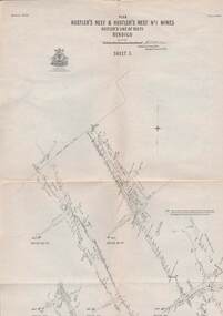
 Bendigo Historical Society Inc.
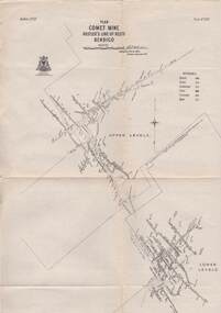
Map - STRUGNELL COLLECTION: HUSTLER'S LINE OF REEFS, BENDIGO, September 1913
Map, Hustler's Line of Reefs, Comet Mine, Bendigo Plan.Plate No.XX1V (24). Map, Bulletin No 33 Signed H.A.Whitelaw Underground survey Office Bendigo September 1913 Drawing shows upper and lower levels and appears to show samples of connecting horizontal shafts with their respective mineral contentsUnderground Survey Office, Bendigo.map, bendigo, comet mine -
Bendigo Historical Society Inc.
Map - JOHN WILLIAMS COLLECTION: PHOTO-MAP OF BENDIGO, 2007
Map, Photo-map of Bendigo,Australian Government Department of Defence,prepared and published by the Defence Imagery and Geospatial Organisation 2007.Copyright Commonwealth of Australia 2007.Australia Photomap 1:15 000. Edition 2-DIGO. WGS84.Grid 1000 metre UTM Zone 55. (number 407 in map cupboard 1)Defence Imagery & Geospatial Organisationmap, bendigo, city streets -
 Bendigo Historical Society Inc.
Map - FORTUNA HUSTLER'S MINE - LONGITUDINAL SECTION OF THE FORTUNA HUSTLER'S MINE
Longitudinal Section of the Fortuna Hustler's Mine on the Hustler's Line of Reef, Bendigo. Bulletin No 33, Plate No IV. Shows poppet legs at the surface level, Datum Line 750 feet above Sea Level, levels and their depths, the amount of gold per ton and some geographical features. Geological Survey of Victoria emblem and signed by H A Whitelaw, Underground Survey Office, Bendigo. Note - Plates 4, 8, 13, 20, 26 & 31 form a Longitudinal Section from Fortuna Hustler's to Hustler's Consols Mine. mining, parish map, fortuna hustler's mine, longitudinal section of the fortuna hustler's mine, geological survey of victoria, h a whitelaw, underground survey office bendigo, hustler's line of reef, hustler's consols mine -
 Bendigo Historical Society Inc.
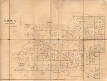
Map - JACK FLYNN COLLECTION: RUNNYMEDE, June 1946
Map: Parish of Runnymede, County of Rodney. Parish plan.By Authority: J.J. Goourley, Government Printer, Melbourne. Drawn and Reproduced at the Lands and Servey, Melbourne, Victoria. June, 1946.map, rodney, parish plan, runnymede -
Bendigo Historical Society Inc.
Map - EAGLEHAWK (PART), 22/01/1882
Map: Parish plan showing area Eastward from Lightning Hill ( number 205 in Map Cupboard 1)map, bendigo, parish plan, eaglehawk, lightning hill -
 Bacchus Marsh & District Historical Society
Map, Maddingley Township, Parish of Parwan, 1880s
This map is dated Sept. 6th 1856. However places in the township of Maddingley which did not appear until the late 1880s such as the Bacchus Marsh Railway Station and line are shown on this map in their correct locations. This suggests the map has been derived from an earlier map. An earlier date of 1843 with a surveyor's name preceding it can also be seen on the map. The map is important because it indicates the location and dimensions of early but now discontinued use of land such as the showgrounds and police paddock and a site reserved for the Church of England which was not ultimately used for a permanent church. A single page paper map showing land allotments, streets, rivers, creeks, park lands, the railway line and Bacchus Marsh railway station in the township of Maddingley. The map is pasted into a bound volume containing 76 maps or plans in total. Bottom of Map: Surveyor-General's Office, Melbourne, Sept 6th, 1856bacchus marsh victoria maps, maddingley victoria maps, land use, maddingley victoria history -
Stawell Historical Society Inc
Map, Stawell Gold Mine, Perspective View Magdala Decline August 1989, August 1989
Shows Mining Levels Drawn By D. Bosher Stawell Joint Venture Victoria SJVmining, gold -
 Bendigo Historical Society Inc.
Map - STRUGNELL COLLECTION: HUSTLER'S LINE OF REEFS, September 1913
Map, Hustler's Line of Reefs, Hustler's Reef & Hustler's Reef No1 Mines Plan, Bendigo.Plate No. XV11 (17).Bulletin No 33 Signed H.A.Whitelaw.Underground Survey Office, Bendigo.map, bendigo, hustler's reef & hustler's reef 1 -
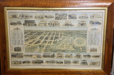 Numurkah & District Historical Society
Map - Print in frame - Numurkah Township 1888, Supplement to the "Numurkah Standard" January 1888 View of Numurkah Victoria Australia
The late Hilda Morieson (very active in early Historical Society) owned the print. It was then passed on to Mary Morieson, then to Rosemary Kennet. It has been passed onto the Historical Society with permission from Ben Morieson, Hilda's grandsonLarge coloured print of supplement to Numurkah Standard 1888. Artist's view/impression of Numurkah streets (map) surrounded by artwork of a number of Numurkah businesses in the town and local district. The print is under glass in a faux-wood-grained framesee photo abovenumurkah standard, numurkah township map, numurkah businesses, 1888, print -
Bendigo Historical Society Inc.
Map - SUTTON GRANGE : COUNTY OF BENDIGO, 21-7-22
Map. Sutton Grange, County of Bendigo, County of Talbot, Mandurang, Ravenswood, Harcourt, Faraday, Hawkestone, Lyell, Sedgwick, Myrtle Creek, Victorian Water Supply - Main Line of Aquaduct from Malmsbury to Sandhurst. By authority A.J. Mullett, Government Printer, Melbourne. Photo-Lithographed at the Department of Lands and Survey, Melbourne by W.J. Butson 21-7-22. Price 1/-. (number 124 in map cupboard 1)A.J. Mullett, Government Printer, Melbourne.map, bendigo, sutton grange -
Bendigo Historical Society Inc.
Map - ELLESMERE, Circa 1878
Map: Ellesmere, County of Bendigo. Parish plan (number 255 in map cupboard 1)map, bendigo, parish plan, ellesmere -
 National Vietnam Veterans Museum (NVVM)
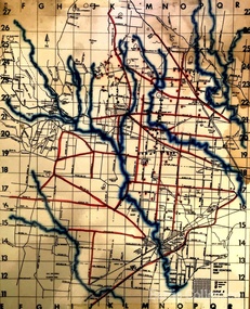
Map, Relief Map
Large scale map of Vietnam showing marked bounaries of provinces. Scale 1:250,000Series L500 Sheet NE 49-13 Edition 3-AMSmap, aattv -
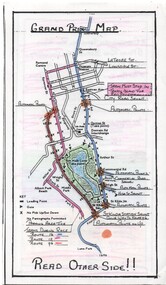 Melbourne Tram Museum
Map, Yarra Trams, "Grand Prix Map", 1996
Laminated sheet - to fit into a pocket - prepared by Greg Rodgers for Camberwell Depot drivers using Park St Kilda Grand Prix services - give details of automatic points, safety notes, details of St Kilda Road points, and what Camberwell drivers are to do. Greg Rodgers advised 5-11-2016, made for the first Grand Prix 1996.trams, tramways, camberwell depot, grand prix, map, public transport, park st st kilda