Showing 2265 items in the category Documentation with item type Map
-
 Bendigo Historical Society Inc.
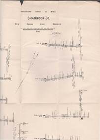
Map - STRUGNELL COLLECTION: UNDERGROUND SURVEY OF MINES, BENDIGO, 28-3-01
Map, Underground Survey of Mines, Bendigo, Shamrock Co., New Chum Line. Surveyed under the Supervision of H.Herman. Signed H.S.Whitelaw 28.3.01H.S.Whitelawmap, bendigo, shamrock co. -
 Ringwood and District Historical Society
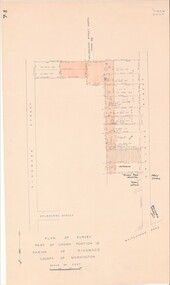
Map - Plan of Survey, Part of Crown Portion 12, Parish of Ringwood, Victoria - circa 1930
Map of area bounded by Ringwood Street, Melbourne Street and Adelaide Street, showing details of Adelaide Street allotments and existing outbuildings. Certificate of Title numbers include Ringwood Street C/T 3418-553, C/T 3563-433, Adelaide Street C/T 7151-047, C/T 7038-465, C/T 7098-464, C/T 7098-465, C/T 3604-635, C/T 8066-900, C/T 3866-118, C/T 3609-728, and C/T Vol 3670 Fol 133992.Subsequent additional notations identifying 1971 closure of Melbourne Street North, and properties of Hone, Patendon, Pines Hosptial, Mail Office, Presbyterian Church and Falconers Grocery Shop on Whitehorse Road corner. -
 Queenscliffe Maritime Museum
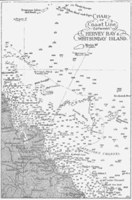
Map - B & W coastal map between Hervey Bay & Whitsunday Island, in Queensland, Coastal map, Queensland, between Whitsunday Island & Hervey Bay, Before donation in 1987
Australian coastal mapsAustralian coastal mapsCoastal 'soundings' map between Hervey Bay & Whitsunday Island, in Queensland, from an unknown book, pre-1987Reverse " NIL "old maps of australian coast -
 Bendigo Historical Society Inc.
Map - WANURP: COUNTY OF BENDIGO, 1/12/33
Map. Wanurp, County of Bendigo, Terrick Terrick East, Mitiamo, Dingee, Milloo, Pannoobamawm. L422+. Photo-Lithographed at the Department of Lands and Survey, Melbourne, Price 2/-. 1/12/33 ( number 411 in Map Cupboard 1 )H.J. Green, Government Printerbendigo, hospital -
Whitehorse Historical Society Inc.
Map, Site management review, 1994
Site management review of Schwerkolt Cottage and Museum for the City of Nunawading.Site management review of Schwerkolt Cottage and Museum for the City of Nunawading. Contains:Diagr.2 - site characteristics; Diagr.9 Site development opportunities Option 1; Diagr.10 Site development opportunities Option 2; Diagr. 11 Option 3; Diagr. 12 Option 4.Site management review of Schwerkolt Cottage and Museum for the City of Nunawading. schwerkolt cottage & museum complex, nunawading and district historical society, city of nunawading -
Bendigo Historical Society Inc.
Map - PANNOOMILLOO : COUNTY OF BENDIGO, 1957
Map. Pannoomilloo, County of Bendigo, Pannoobamawm, Milloo, Diggorra, Warragamba. Elmore Cohuna Railway. Waranga Mallee Channel. By authority W.M. Houston, Government Printer, Melbourne. Drawn and reproduced at the Department of Lands and Survey, Melbourne 1957. Price 2/-. (number 83 in map cupboard 1)W.M. Houston, Government Printer, Melbourne.map, bendigo, pannoomilloo -
 Lilydale RSL Sub Branch
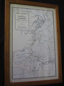
Map - Framed copy of map, The canadian and American Seaboard - January to July 1942
Framed copy of mapThe Canadian and American seaboard - January to July 1942. Shows Merchant ships sunk, U boats sunk and coastal convoys organised by July 1942. -
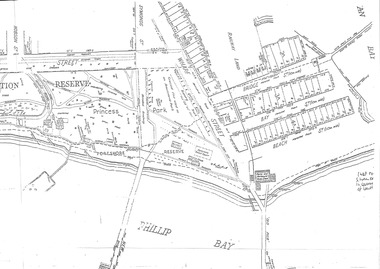
![Map, Public Lands Office, Township of Sandridge [cartographic material] / lithographed at the Public Lands Office, March 30th 1859, 30 March 1859](/media/collectors/4f729f5897f83e0308601603/items/63c6354eae7bf372478c58b7/item-media/63c635d4ae7bf372478c7627/item-fit-380x285.jpg) Mission to Seafarers Victoria
Mission to Seafarers VictoriaMap, Public Lands Office, Township of Sandridge [cartographic material] / lithographed at the Public Lands Office, March 30th 1859, 30 March 1859
The map shows where the land of the Customs House was and where the Bethel church was built in 1860. It also shows the name Gregory, a family of land owners who became the managers of the new building on the same site in 1889.sandridge, bethel church, customs house, gregory -
Bendigo Historical Society Inc.
Map - SEDGWICK, 5/04/1881
Map: Parish of Sedgwick, County of Bendigo. Parish plan (number 312 in map cupboard 1)map, bendigo, parish plan, sedgwick -
Merbein District Historical Society
Map, Township of Merbein - Sale of Allotments, 29 Jul.1914
-
Moorabbin Air Museum
Map (item) - Silk Map Holland Belgium France Germany Switzerland Sheet C and D
-
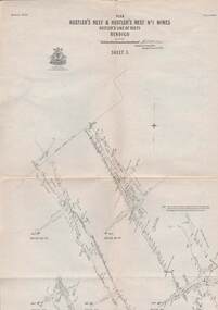 Bendigo Historical Society Inc.
Map - STRUGNELL COLLECTION: HUSTLER'S LINE OF REEFS, September 1913
Map, Hustler's Line of Reefs, Hustler's Reef & Hustler's Reef No1 Mines Plan, Bendigo.Plate No. XV11 (17).Bulletin No 33 Signed H.A.Whitelaw.Underground Survey Office, Bendigo.map, bendigo, hustler's reef & hustler's reef 1 -
Whitehorse Historical Society Inc.
Map, Burwood Road, Box Hill City, 15/02/1952 12:00:00 AM
Detailed map of subdivision along the north side of Burwood Road, Box Hill between Station Street and Middleborough Road.Detailed map of subdivision along the north side of Burwood Road, Box Hill between Station Street and Middleborough Road. Shows many block owners, types of buildings, nature of fencing. Marked as 'Survey Plan No 5440'.Detailed map of subdivision along the north side of Burwood Road, Box Hill between Station Street and Middleborough Road. maps, burwood road, burwood, andrews street, greenwood street, tennyson street, middleborough road, station street -
Clunes Museum
Map - MAPS
A MAP OF CLUNES TOWNSHIP. ORIGINAL AND COPY. ALL STREETS WITH ALLOTMENT NUMBERS CRESWICK CREEK - KILKENNY CREEK - BALLARAT TO MARYBOROUGH RAILWAY LINE.CLUNESlocal history, document, maps, clunes township -
Bendigo Historical Society Inc.
Map - HEATHCOTE, 11/04/1935
Map: Parish of Heathcote, County of Dalhousie. Parish plan (number 320 in map cupboard 1)map, dalhousie, parish plan, heathcote -
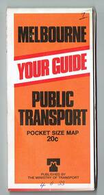 Melbourne Tram Museum
Map, Ministry of Transport, "Melbourne Transport Services Map - Tram, Train and Bus Services", 1977
Fold out map (27 sections 9 across x 3 deep), coloured of Melbourne's Tram and Bus routes, route numbers, rail lines, detailed for the central part of Melbourne and insert section for Frankston. On rear description of routes, private bus routes and map of Melbourne metro lines. Map No. 7, 1977. Has contact details for bookings and lost property etc. Priced 20c. 1977, route 59 showing as terminating opposite Essendon Airport.On front cover in ink "" in top right hand corner and "4 G 33 " along bottom edge.trams, tramways, melbourne, map, tram & bus services, railways, mmtb, minister for transport -
 Bendigo Military Museum
Map - MAP FRANCE, FRAMED, Ordinance Survey 1918, c.1918
Thin wooden frame with green border, glass front. Amiens,France. War Office October 1915.Amiens France 1:100,000 For Office Use Onlydocuments-maps, france, frame accessories, amiens -
Port Melbourne Historical & Preservation Society
Map - MHT General Plan showing Harbour improvements recommended Sir John Coode, Thomas Kell Lith, 1800s
Black and white map "Melbourne Harbour Trust, General Plan showing Harbour improvements, as recommended by Sir John Coode in his report of 17th February 1879" Showing proposed Coode canal and Sandridge, Hobson's Bay, North Williamstown, Footscray, the City, Emerald Hill and also the buildings of "Kitchen and Son" . (copy of original)industry, manufacturing, engineering department, borough of sandridge, engineering - canals and drainage, melbourne harbor trust - port of melbourne authority, j kitchen & sons pty ltd, sir john coode -
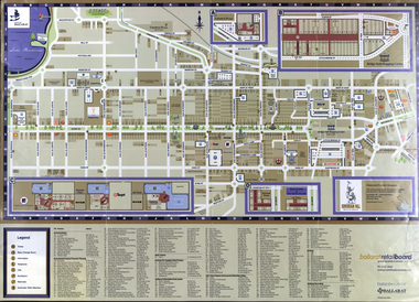 Federation University Historical Collection
Map, Eastern Ballarat (c) Retail and Business Guide, 2004
Map of Ballarat East including Brown Hill, Mount Clear and Buninyong.brown hill, mount clear, mount helen, buninyong, university of ballarat -
 Bacchus Marsh & District Historical Society
Map, Allotments in the Village of Rowsley, Parish of Gorrocburkghap, County of Grant c.1856
Rowsley is a locality 11 kilometers south-west of Bacchus Marsh. The date of this map is uncertain. A very similar map held by the State Library of Victoria (SLV) contains slightly more information than this copy and is dated as an 1856 map. SLV reference: 'Allotments in the Village of Rowsley, Parish of Gorrocburkghap, County of Grant', by T. Nixon, Assistant Surveyor, May 1856 ; Surveyor General’s Office, July 18 1856 (lithographed by R. Meikle). (1856). Melbourne: Surveyor General’s Office. MAPS 820 BJE 1837- ROWSLEY 1856. A single page paper map. A cadastral map of the Village of Rowsley in Victoria, showing numbered land allotments. 57 allotments are shown on the map and some areas set aside as reserves. Allotments 8, and 10-16 are outlined in red ink and allotment 9 has a cross in red ink on it. The map is pasted into a bound volume containing 76 maps or plans in total. High resolution digital image stored on BMDHS computer network. rowsley victoria history, rowsley victoria maps -
Stawell Historical Society Inc
Map, Western Mining Corporation Limited, Shaft Location Plan April 1981, 1981
Western Mining Corporation Ltd Shaft Location Plan 1981 Very Large Plot Showing Contours and Streets Without names. Sheet 1 0f 2 stawell, mining -
 Queenscliffe Maritime Museum
Map - Port Phillip Bay at Queenscliffe 1936, Map of Queenscliffe Parks & Foreshore, unknown
Queenscliffe life c1936Map of Queenscliffe in c1936copy of an L-shaped map of 1936 Queenscliffe foreshoreReverse - " nil ".historical references -
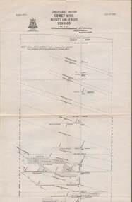 Bendigo Historical Society Inc.
Map - STRUGNELL COLLECTION: HUSTLER'S LINE OF REEFS, BENDIGO, September 1913
Map, Hustler's Line of Reefs, Comet Mine, Longitudinal Section.Plate No.XXV1 (26).Bulletin No 33 Signed H.A.Whitelaw Underground survey Office Bendigo September 1913 Drawing shows the vertical shaft descending to over 1692 feetUnderground Survey Office, Bendigo.map, bendigo, comet mine -
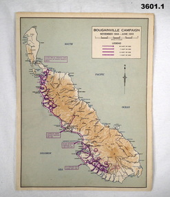 Bendigo Military Museum
Map - MAPS, ISLANDS WW2, Post 1945
Items were owned by William John GARLAND, 5th Army Troop. Illustrated information of the named campaigns of 1944-45..1) Coloured paper map of Bougainville Campaign, New Britain Campaign & Aitape - Wewak Campaign. .2) Coloured paper map of Tarakan Campaign, Balikpapin Campaign & North Borneo Campaign.maps, bouganville, tarakan, islands -
Glenelg Shire Council Cultural Collection
Map - Brochure/Map - Great South West Walk, Oct-83
Brochure/map. Great South West Walk. Track notes for the walk on one side, map showing Great South West Walk on the other, white with blue print and images; map multi-coloured. Front of brochure has photo of Shelley Beach, in blue and white, yellow print, yellow GSWW logo. Back cover yellow, black print. Contact details.great south west walk -
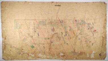 Bendigo Historical Society Inc.
Map - MARONG, Circa 1871
Map; Marong, Hand Draughted parish planmap, bendigo, parish plan, marong -
Bendigo Historical Society Inc.
Map - CAMPBELL COLLECTION: BENDIGO AND DISTRICT MAPS, 2-2-29
Map. Wellsford, Parishes of Wellsford and Axedale, Scale 20 chains to 1 inch. Total area 4994 acres. Prepared in W.P.B. from A and P Plans, by W.J.G.2-2-29. Top left of map are directions to Fosterville, Huntly & Bendigo. (number 361 in map cupboard 1)W.J.Galbraithmap, bendigo, parish plan -
Bendigo Historical Society Inc.
Map - CITY OF BENDIGO SHEET NO. 5, Circa 1890's
Map: City of Bendigo sheet No. 5. Parish plan ( number 213 in Map Cupboard 1)map, bendigo, parish plan, bendigo -
Whitehorse Historical Society Inc.
Map, Shires of Boroondara, Nunawading, C1856
Photocopy of part of very early map covering parts of Boroondara and Nunawading.Photocopy of part of very early map covering parts of Boroondara and Nunawading. Marks old tracks on lines of Whitehorse and Canterbury Roads.Photocopy of part of very early map covering parts of Boroondara and Nunawading.maps, shire of nunawading, shire of boroondara, barkers track, deep creek, nunawading -
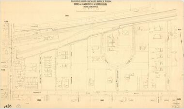 Camberwell Historical Society
Map (Item) - MMBW map, Melbourne and Metropolitan Board of Works, Melbourne and Metropolitan Board of Works - Shire of Boroondara and Camberwell - Detail Plan no. 1860, August 1904
Lithographer E.H.H., Exd J.W.D, June 1904, No. 70. 40P.15W.melbourne and metropolitan board of works, map, camberwell, cartography