Showing 2222 items
matching documentation
-
 Bendigo Historical Society Inc.
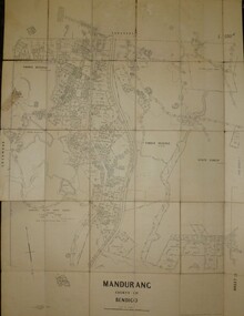
Map - JACK FLYNN COLLECTION: MANDURANG SHEET 2, March 1947
Map: Parish of Mandurang, Sheet 2, County of Bendigo. Parish plan.By Authority J.J.Gourley Government Printer Melbourne. Drawn and Produced at the Dept, of Lands and SurveyMelbourne, Victoria. March 1947.map, bendigo, parish plan, mandurang -
 Federation University Historical Collection
Map, Ballarat and Sebastapol Gold Mines, Late 19th Century
colored printed map on paper lined onto linen backingprinted "Rider & Mercer's Plan of the Ballarat & Sebastapol Gold Mines Scale 30 Chains to One Inch"gold mines, mine allotment map, mining leases, ballarat, sebastopol, rider and mercer, golden shaft co, prince of wales and bonshaw united, leviathan gold mines, holst and co, speedwell co, sebastopol plateau, rothschild co, tower hill co, south plateau, south star co, band of hop and albion consols, prince regent co, chenhall and co, despza, buninyong estate, one eye hully, winter's freehold, luplau plateau, e. morey, carrill's quartz -
 Whitehorse Historical Society Inc.
Map, State Electoral Districts, 1978
State Electoral Districts [Melbourne] 1975. Redivision (1977 subdivisions0. Scale 1: 90,000State Electoral Districts [Melbourne] 1975. Redivision (1977 subdivisions0. Scale 1: 90,000State Electoral Districts [Melbourne] 1975. Redivision (1977 subdivisions0. Scale 1: 90,000electoral boundaries, victoria. parliament. legislative assembly -
 Ringwood and District Historical Society
Map - Plans of Subdivision, Part of Crown Allotments 35 & 39, Parish of Warrandyte
Survey maps of stages 1, 2 & 3 of residential allotments in Kalinda Road and Grayling Crescent, Ringwood, Victoria. (Undated, circa 1960). Some allotments are marked with real estate information and prices in pre decimal £s.Adshead & McGuire, Land Surveyors L.S. M.I.S. (Aust), 268 Albert Street East Melbourne (Ref 118/2a b &c) Tel 41-6960. The land colored blue is set apart for drainage & sewerage purposes. Reference Marks (R.M's) are Gal Iron Pipes 12"x1". Levels shown are to M.M.B.W. Datum. The land shown hatched is subject to innundation. -
Bendigo Historical Society Inc.
Map - BENDIGO GOLD FIELDS
Map, Bendigo Gold Fields, copy, mining leases, the numbers of their leases, as well as streets of Bendigo.( number 408 in Map Cupboard 1).bendigo, mining, mining leases -
Port Melbourne Historical & Preservation Society
Map - Road plans for Fishermens Bend, R S Atkinson, 30 Apr 1946
CRB Map outlining road plans for Fishermens Bend and including the site of the Commonwealth Aircraft Corporation, Aerodrome, General Holdens and C.S.R.I., 1946transport - aviation and aerodrome, industry - manufacturing, fishermans bend -
Bendigo Historical Society Inc.
Map - CAMPBELL COLLECTION: BENDIGO AND DISTRICT MAPS, 12-2-29
Map. Axedale, Parish of Ellesmere and Axedale, Total area 4156 acres, Prepared in W.P.B. from A. and P. Plans by W.J. Galbraith 12-2-29. (number 383 in map cupboard 1)W.J.Galbraithmap, bendigo, agricultural lands -
Bendigo Historical Society Inc.
Map - DARGILE, 14/10/1906
Map: Parish of Dargile, County of Rodney. Parish plan (number 324 in map cupboard 1)map, rodney, parish plan, dargile -
Bendigo Historical Society Inc.
Map - WESTON RESURVEY, June 20th 1875
Map: Weston, Resurvey.Hand draughted Parish plan (number 292 in map cupboard 1)map, parish plan, weston -
 Kew Historical Society Inc
Map, MMBW, MMBW Plan No.40 Collingwood & Kew, 1900-1910
The Melbourne and Metropolitan Board of Works (MMBW) was established by an act of the Victorian Parliament in 1890 to prepare for and to implement a sewerage and water reticulation system across what was then inner Melbourne, its surrounding and middle distance suburbs, including Kew. The MMBW was disbanded in 1991.The map collection of the Kew Historical Society has at its core the historic maps assembled and originally stored in the City Engineer's Department of the City of Kew. These include maps in a number of scales. The vast majority of maps were produced by the MMBW in the first two decades of the twentieth century, and are solid working maps, backed by linen for durability. These maps are historically significant to Kew, the City of Boroondara and to the history of the development of state utilities in Victoria. A number of the Kew maps have additional details added by former municipal officers, including the levels reached by various floods. As these were working documents, information was added to them long after the period of their initial production and distribution.Early map of part of the Borough of Kew, created in the first decade of the twentieth century, at a scale 160 ft to 1 inch. The map covers what was then the south western section of Kew, bordered on its north by Studley Park Road, in the west by Walmer Street and the River Yarra, by High Street South and Princess Street in the East and Barkers Road in the south. The map shows the extent of urban development by that time, prominent institutions and the outlines of built structures in the municipality. Contour lines and historic flood levels were added in ink to the map at a later stage.MELBOURNE AND METROPOLITAN BOARD OF WORKS / PLAN NO. 40 / COLLINGWOOD & KEWmelbourne & metropolitan board of works, mmbw maps, mmbw plans, borough of kew, cartography -
Bendigo Historical Society Inc.
Map - NERRING SHEET 2, 21/12/1894
Map[: Nerring sheet 2 ( number 187 in Map Cupboard 1)map, bendigo, parish plan, nerring -
Canterbury History Group
Map - Logan Estate, Canterbury
Real estate advertisement distributed by Sinclair & Company of a reproduction of a historical map of the Logan Estate and a short history on the reverse side.canterbury, logan estate, canterbury road, prospect hill road, marlowe street, logan street, canterbury railway station, logan family, sinclair & company, clairmont estate, molesworth street -
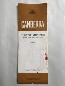 Robin Boyd Foundation
Map, Universal Business Directories, Canberra Tourist Map, 1970
walsh st library -
Stawell Historical Society Inc
Map, T.F. McGauran, William Couty of Borong 1891, 1891
Stawell Water Supply Reserve. Grampians State Forest. Dairy Creek, Fyans Creek, Barney's Creek, Bovine Creek, Glasstree Creek, Stoney Creek. Stawell Water Supply Aquaduct Fkuming Tunnel.A2 Parish Map of Willam Inculdin Stawell Water Supply Reserve and Creeks. Marked in redPhoto Lithographed at the Department of Lands and Survey Melbourne. By T.F. McGauran 20.07.91 water supply survey -
Bendigo Historical Society Inc.
Map - GOORNONG, 19/04/1873
Map: Goornong, Hand draughted parish plan ( number 238 in Map Cupboard 1)map, bendigo, parish plan, goornong -
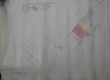 Bendigo Historical Society Inc.
Map - BENDIGO WEEROONA GASWORKS MAP/PLAN COLLECTION: CROWN ALLOTMENTS 13/14, 1942
Map: crown allotments 13 and 14, Sec. E. City of Bendigo, Parish of Sandhurst. Shows site of Bendigo Gasworks. Prepared by Garnel Gordon Birch Surveyor, 12.6.1942map, bendigo, gasworks, gas company, plans -
 Bacchus Marsh & District Historical Society
Map, Maddingley Township, Parish of Parwan, 1880s
This map is dated Sept. 6th 1856. However places in the township of Maddingley which did not appear until the late 1880s such as the Bacchus Marsh Railway Station and line are shown on this map in their correct locations. This suggests the map has been derived from an earlier map. An earlier date of 1843 with a surveyor's name preceding it can also be seen on the map. The map is important because it indicates the location and dimensions of early but now discontinued use of land such as the showgrounds and police paddock and a site reserved for the Church of England which was not ultimately used for a permanent church. A single page paper map showing land allotments, streets, rivers, creeks, park lands, the railway line and Bacchus Marsh railway station in the township of Maddingley. The map is pasted into a bound volume containing 76 maps or plans in total. Bottom of Map: Surveyor-General's Office, Melbourne, Sept 6th, 1856bacchus marsh victoria maps, maddingley victoria maps, land use, maddingley victoria history -
Stawell Historical Society Inc
Map, Section 2 (Taken from Plan No 959), 1894
Section 2 (Taken from Plan No 959)stawell -
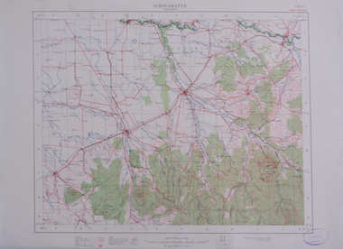 Federation University Historical Collection
Map, Wangaratta, not dated
Printed colour map on paperwangaratta, broken river, ovens river, benalla, euroa -
Stawell Historical Society Inc
Map, Parish of Stawell, County of Borung, Stawell Township, Sheet 1, 1879
Parish of Stawell, County of Borung, Stawell Township, Sheet 1stawell -
Whitehorse Historical Society Inc.
Map, Broadbents map no 230, To and from Clifford Park, c1955
Map - To and From Clifford Park by Broadbents 1955 - 56 prepared for a scout jamboree.maps, eastern suburbs (melbourne), scout groups -
Stawell Historical Society Inc
Map, Whitehead's Map of Victoria, with Alphabetical Key, 1869
Whitehead's Map of Victoria, with Alphabetical Keystawell -
Glen Eira Historical Society
Map - Kilvington Baptist Girls Grammar School
One hard copy and one photocopy of Kilvington Baptist Girls Grammar School Planning brief dated October 1982. The brief details the current needs of the school and has been written to spell out a forward plan for development in the foreseeable future. It includes data on the current forecast enrolments at primary and secondary levels as well as the current and future use and development of the buildings and their use. Author of the brief is unknown.kilvington baptist girls grammar school, schools, ormond, lillimur road, walsh street, ormond girls school, kilvington girls grammar school, leila road, katandra road, ulupna road -
 Marysville & District Historical Society
Map (Item) - Tourist and business map, Narbethong Community and Tourism Group, the Gateway TOURIST AND BUSINESS MAP, 08-2009
A tourist and business map of Narbethong, Buxton, and Taggerty. This map was produced by the Narbethong Community and Tourism Group Inc in August 2009. It was produced to promote the natural attractions, adventure activities, and food trail from the Black Spur, through Narbethong, Buxton, and Taggerty.A tourist and business map of Narbethong, Buxton and Taggerty.This publication has been produced by the Narbethong Community and Tourism Group Inc./ (NCTG) The information provided in this publication has been supplied by the individual/ members. NCTG takes no responsibility for its accuracy./ August 2009narbethong, buxton, taggerty, victoria, australia, tourist and business map, the gateway tourist and business map, black spur motel & caravan park, woodlands rainforest retreat, chestnut glade, black spur inn, wombat cottage, abbey lake luxury b&b spa cottages, camp narbethong, marapana farm stay b&b, mantirri b&b, little dene garden cottages, nareen cabins, silverstream b&b cottages, buxton hotel motel, south cathedral farm luxury b&b cottages, cathedral view b&b retreat, kingbilli country estate, cathedral valley farm, pinjarra gardens, willowbank at taggerty, sarsens rest, yarrolyn caravan park, danico design counted cross stitch, things of sand & stone, buxton zoo nursery, safetrek 4wd services, mystic mountains ski hire & outdoors, pnl 4wdriving, buxton trout and salmon farm, buxton bait and tackle, black spur roadhouse, tudor lodge service station roadhouse & ski hire, buxton roadhouse, buxton p.o. general store, igloo roadhouse, henry v111 manor house, buxton hotel, butters cafe, wagtail wines, little river wines, narby eggs, marapana agistment park, carmyle farm, hazelwood hazelnuts, cathedral view naturall therapies, cre8ing growth, linda hailey, naby cabinets, gb timber, narbethong timber & trading, rb automotive repairs, buxton car care, martyn slade building design, taggerty vet clinic -
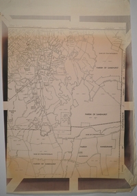 Bendigo Historical Society Inc.
Map - CAMPBELL COLLECTION: BENDIGO AND DISTRICT MAPS
Map. Parish of Sandhurst, Shire of Strathfieldsaye, Mandurang Parish, Junortoun.map, bendigo, city streets -
Whitehorse Historical Society Inc.
Map, Nunawading Planning Scheme. Local Section, 1993
Map of City of Nunawading.Map of City of Nunawading showing zoning of areas by means of colours and some detailed designations. Note: ' This map contains amendments as at 14 Oct 1993'Map of City of Nunawading.city of nunawading, maps, land use -
Bendigo Historical Society Inc.
Map - BENDIGO AND DISTRICT PARISH MAPS, 21-10-26
Map. Sandhurst, County of Bendigo, City of Bendigo, Strathfieldsaye, Mandurang, Marong, Nerring, Borough of Eaglehawk, Township of Kangaroo Flat, Lockwood, Huntly, Epsom, Wellsford. By Authority H.J. Green, Government Printer, Photo-Lithographed at the Department of Lands and Survey, Melbourne bj W.J Butson 21-10-26,Price 1/-. (number 13 in map cupboard 1)By Authority H.J. Green, Govt. Printermap, bendigo, sandhurst -
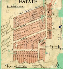 Ringwood and District Historical Society
Map, Subdivision Plan, Loughnans Road, Ringwood - circa 1922
Green card with cut-out map of residential allotments, some marked "sold". "Plan of Estate" includes Wonga Road, Loughnans Road, William Street, Andrew Street, Harrison Street, and Munro Street, Ringwood. (Surrounding area is part of Ringwood Park Estate featured in seperate 1922 auction flyer).Handwritten notations - (northern section) {£2-10/- per foot. £5 deposit bal £1 per month} All the rest £2 per foot, value same as above. Licensed Surveyors - W.J. & A.W. Kenhardt, 352 Collins Street, Melbourne. -
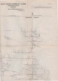 Bendigo Historical Society Inc.
Map - STRUGNELL COLLECTION: UNITED HUSTLER'S & REDAN & K.K.MINES, September,1913
Map, United Hustler's & Redan & K.K.Mines, Hustler's Line of Reefs, Bendigo.Plat No.XXX1(31),. NOTE:- Plates 4,8,13,20,26,& 31 form a Longitudinal Section from Fortuna Hustler's to Hystler's Consols Mine. Bulletin 33.Signed H.A.Whitelaw. Drawing shows the vertical shafts descending to over 1932 feet and 1805 feet respectively .Underground Survey Office, Bendigo.map, bendigo, united hustler's, redan, k.k.mines -
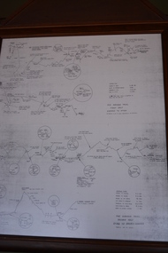 Wangaratta RSL Sub Branch
Map - Framed Map
Large brown timber framed black and white map with dotted lines arrows and circles.The Kokoda Trail First Half Kokoda to Efogi Second Half Efogi to Owers Cornerkokoda trail, papua new guinea, world war 2