Showing 2222 items
matching documentation
-
 Bacchus Marsh & District Historical Society
Map, Mooradoranook Parish Map, County of Grant
A single page paper map showing the map for the Parish of Mooradanook in the County of Grant. Cadastral map showing land ownership. The map is pasted into a bound volume containing 76 maps or plans in total. High resolution digital image stored on BMDHS computer network. Photo lithographed at the Department of Lands and Survey Melbourne by T. F. McGauran, 27.11.06mooradoranook parish maps, mooradoranook parish plan, bacchus marsh region parish plans -
 Bacchus Marsh & District Historical Society
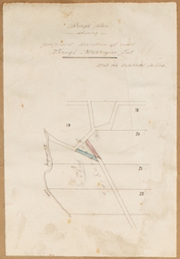
Map, Rough plan showing proposed deviation of road through McKenzie's Flat
The date of this map or plan is uncertain. McKenzie's Flat is a bushland picnic area on the Lerderderg River in the Lerderderg State Park close to Bacchus Marsh. Single page map showing a proposed deviation of the road near the McKenzie's Flat area close to Bacchus Marsh. The proposed deviation is shaded in pink, The existing road section to be replaced is shaded in blue. No scale is indicated. Part of a set of maps which are pasted into a bound volume containing 76 maps or plans in total. High resolution digital image stored on BMDHS computer network. mckenzies flat bacchus marsh, bacchus marsh roads and streets -
 Bendigo Historical Society Inc.
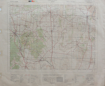
Map - SALISBURY : COUNTY OF BENDIGO, 1965
Map. Salisbury, County of Bendigo, Pompapiel, Yallook, Yarraberb, Yarrayne, Bullock Creek. Drawn and reproduced at the Department of Lands and Survey, Melbourne. Price $1.00. 1965. By authority A.C. Brooks, Government Printer, Melbourne. (number 28 in map cupboard 1)A.C. Brooks,Government Printer, Melbourne.map, bendigo, salisbury -
Bendigo Historical Society Inc.
Map - JANIEMBER WEST : COUNTY OF BENDIGO, September 1955
Map. Janiember West, County of Bendigo, Powlett, Janiember East, Jarklan, Kinypanial, River Loddon, Kelsh's Lagoon. By authority W.M. Houston, Government Printer. Drawn and reproduced at the Department of Lands and Survey, Melbourne. Price 2/-.September 1955. (number 64 in map cupboard 1)W.M. Houston, Government Printermap, bendigo, janiember west -
 Federation University Historical Collection
Map, Lancefield, 1947
Printed coloured map on paperlancefield -
 Federation University Historical Collection
Map, South East Australia, not dated
Printed colour maptasmania, new south wales, victoria -
 Bendigo Historical Society Inc.
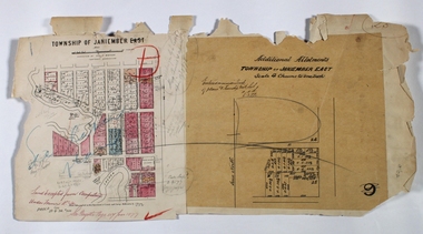
Map - JANIEMBER EAST, 12/09/1876
Map: Two maps applied to the one backing, Township of Janiember East. Additional allotments, Townshihp of Janiember Eastmap, bendigo, janiember east, allotments janiember east, serpentine -
Bendigo Historical Society Inc.
Map - SERPENTINE, No date Visible
Map: Township of Janiember (name crossed out and 'Serpentine' hand written in its place, Parish of Janiember east, County of Bendigo ( number 156 in Map Cupboard 1)map, bendigo, township, serpentine, janiember, parish of janiember east, county of bendigo -
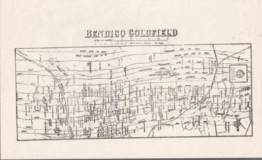 Bendigo Historical Society Inc.
Map - BENDIGO GOLDFIELD MAP
Two not very clear copies of the Bendigo Goldfield Map. Streets, Railway Line, Lines of Reefs and mines are shown. Dept. of Mines, Victoria printed on the map. Shows reefs from Bird's Line of Reefs to Lightning Hill Line of Reef.map, bendigo, goldfields, bendigo goldfield map, lines of reefs, dept. of mines victoria -
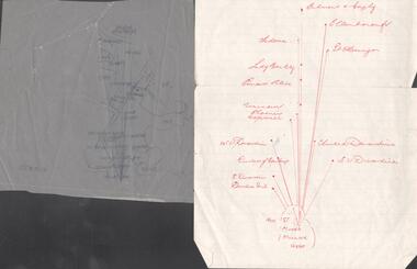 Bendigo Historical Society Inc.
Map - SNOB'S HILL - PLAN OF SNOB'S HILL AREA
Plan drawn on tracing film of sand heap, dams, trig point and mines. Some un-named streets are also drawn in. Piece of notepaper has mines drawn in on a larger scale. Notes prepared by Albert Richardson.map, bendigo, goldfields, snob's hill, plan of snob's hill area, new st mungo mullock heap, duchess trib, s devonshire, duchess of edinburough, w u devonshire, hopewell, phoenix, unicorn, princess alice, lady barkly, sadowa, e u devonshire, united devonshire, l?, ellenborough, belmont & saxby, snob's hill -
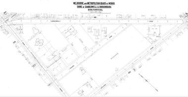 Camberwell Historical Society
Map (Item) - MMBW map, Melbourne and Metropolitan Board of Works, Melbourne and Metropolitan Board of Works - Shire of Boroondara and Camberwell - Detail Plan no. 1852, August 1904
Lithographer L.E, exd W.A.L., August 1904, no. 95. 40P. 15Wmelbourne and metropolitan board of works, map, camberwell, cartography -
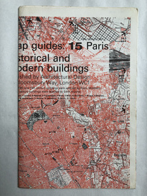 Robin Boyd Foundation
Map, Architectural Design, Map guides: 15 Paris historical and modern buildings
Map of significant Paris buildings and categorizing of historical buildings.map, paris, historical buildings, modern buildings, walsh st library -
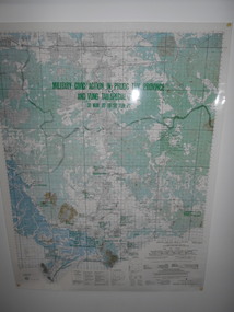 National Vietnam Veterans Museum (NVVM)
Map, Military Civic Action in Phuoc Tuy Province
Laminated map of civil action in Phuoc Tuy Province and Vung Tau Special Zone in the period of March 1970 to June 1971. Details housing, schools, hospitals & infrastructure projects.civil action, phuoc tuy, vung tau -
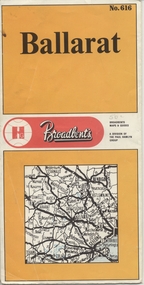 Ballarat Tramway Museum
Map, Broadbent's, "Broadbent's Map 616 Ballarat", c1960
Yields information about the extent of Ballarat in the early to mid 1960's shows the tram lines and other rail lines in the district.Printed street map titled "Broadbent's Map 1616 Ballarat" printed in colour on one side only of a folded (10) sheet. Shows the suburbs of Ballarat, tram lines, has a scale in miles, Ballarat District map and an index to streets. Also points interest and historical interest. also shows railways lines. Map used as the base for the tram line map in the display area in the depot. Large Res scan made 28/1/2011."50c" in pencil on front cover.trams, tramways, map, ballarat, broadbent's, railways -
Stawell Historical Society Inc
Map, Parish of Stawell, Sheet 4, 1958
Parish of Stawell, Sheet 4stawell -
Bendigo Historical Society Inc.
Map - BAMAWM ESTATE, 24/02/1931
Map: Bamawm Estate, Aquired under closer settlement Act 1904, County of Bendigo. Parish plan Canvas backed ( number 129 in Map Cupboard 1)map, bendigo, rural, bamawm estate, closer settlement acts 1904, county of bendigo -
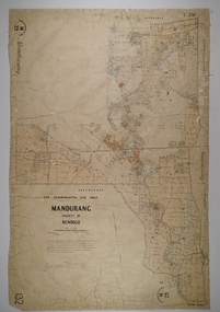 Bendigo Historical Society Inc.
Map - MANDURANG 2, Date unreadable
Map: Mandurang, County of Bendigo. Parish plan Examined by W. S. Stephen 11.12.79 W. E. Porter Draughtsman July 1879map, bendigo, parish plan, mandurang, w.s. stephen, w. e. porter -
Stawell Historical Society Inc
Map, R.O. Robson - Authorised Surveyor, Road from Glenorchy to near Geary's Selection Callawaddy 1880, 29.04.1880
Survey for Road CreationCloth Backed Map. Plan of Road.Parishes of Richella & Callawadda. County of Borong. Plan of Road. R.O. Robson Authorised Surveyor Stawell 29.04.80 -
Bendigo Historical Society Inc.
Map - BAGSHOT, November 1948
Map: Bagshot, County of Bendigo. Parish plan ( number 167 in Map Cupboard 1)map, bendigo, parish plan, bagshot, county of bendigo -
 Bayside Gallery - Bayside City Council Art & Heritage Collection
Map, H.B. Foot, Plan of the Brighton Estate containing 5120 acres, first special survey at Port Phillip, c. 1842
This plan records the Brighton Estate, also known as Dendy's Special Survey. In 1840 Henry Dendy, a farmer in Surrey, England acquired a "Special Survey" from the Commissioners for Land and Emigration which gave him the right to choose land in Port Phillip for the low price of £1 per acre for 5120 acres. Dendy appointed Jonathan Binns Were, as his agent, who later became a partner. Together, Dendy and Were decided on an area 5 miles south from Melbourne, bounded by North Road, East Boundary Road, South Road and to the west by Port Phillip Bay. Their Brighton Estate was first surveyed by T. S. Townsend in May 1841 and was re-surveyed by Robert Hoddle. Dendy and Were were making plans to sell the land and advertised a 30-guinea prize for the best subdivision which was to be divided into a village, marine residences, suburban and cultivation allotments, with the remainder being divided into country sections. The competition was won by H.B. Foot, who planned the village around a reserve and crescents and a 'green belt' forming the town boundary. brighton estate, dendy's special survey, special survey, henry dendy, jonathan binns were, w.b. were, survey, plan, map, brighton, george ward cole, baker's lithographer, hibernian, subdivision, town planning, cartographic material, h.b. foot -
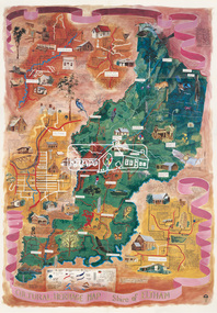 Eltham District Historical Society Inc
Map (item), Megan Evans, Cultural Heritage Map, Shire of Eltham, 1993
Copy of artist's map of the Shire of Eltham with numerous historical and cultural places of interest illustrated and notated including evidence of original Wurundjeri occupation and local flora and fauna. The original watercolour is held in the Nillumbik Shire Council Civic Collection. "Evans remembers being surprised they had asked an artist to create this map rather than a designer. Originally made as a watercolour, the map was later made into posters and adorned many homes around the area. The map creatively interprets the town and provides a wayfinding to both cultural and historical points in the area." Nillumbik Arts News December 2023. artist, buildings, cultural heritage map, fauna, flora, map, megan evans, shire of eltham, wurundjeri -
 Bendigo Historical Society Inc.
Map - JACK FLYNN COLLECTION: TOWNSHIP OF STANHOPE, December 1950
Map: Township of Stanhope, Parish of Girgarre, County of Rodney. Parish plan.By Authority J. J. Gourley, Government Printer, Melbourne. Drawn and Reproduced at the Dept, of Lands and Survey, Melbourne, Victoria.map, rodney, township, stanhope -
Whitehorse Historical Society Inc.
Map, City of Nunawading, n.d
Map of the City of Nunawading with a list and locations of 48 schools.Map of the City of Nunawading with a list and locations of 48 schools. Scale: 1 mile = 3.75 inches.Map of the City of Nunawading with a list and locations of 48 schools. city of nunawading, schools -
Federation University Historical Collection
Map, Town of Buninyong, 1927, 09/1927
The date of this map is September 1927 revised from the original 1910 map. Buninyong was created a district on 09 July 1858, proclaimed a Shire on 16 February 1864, and the Buninyong Borough united on 01 October 1915.Township plan of the Town of Buninyong showing government roads and crown allotments. Earlier detail pencilled on (commercial buildings, etc) appears to be from an 1850 survey. Scale: 4 chains to 1 inch (1:3168)buninyong, map, buninyong botanical gardens, tannery dam, buninyong reservoir, chapel school, rev. hastie -
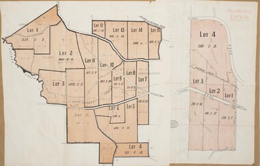 Bacchus Marsh & District Historical Society
Map, Glenvale Estate and Glenmore Estate Land Sales 1909
The two land auction plans shown in this record relate to the sale of land from the Glenmore Estate property. The Glenmore property was established by C.J. (Charles James) Griffith and James Moore around 1840. Moore sold his interest to Moelesworth Greene in 1848. Greene was the nephew of the other owner Charles Griffith who died in 1863. From around the 1870s onwards parts of the Estate were subdivided and put up for sale or lease. In subsequent decades more changes in ownership occurred. These two plans document another major sale of the land from the original Glenmore Estate including part of the estate which had become used for dairy farming and was at that time known as the Glenvale Estate. Two single page maps pasted together on a single page of a bound volume of maps. One map shows 15 separate lots of land for sale. The other map which has the words 'Glenvale Estate' at the top of the map shows 4 lots of land for sale. Both parcels of land were originally part of the Glenmore Estate a pastoral holding belonging to C.J. Griffith and James Moore which the began in the Rowsley area south west of Bacchus Marsh in the 1840s. The maps are pasted into a bound volume containing 76 maps or plans in total. High resolution digital image stored on BMDHS computer network. bacchus marsh victoria maps, glenvale estate property, glenvale estate land sales, glenmore estate, glenmore station -
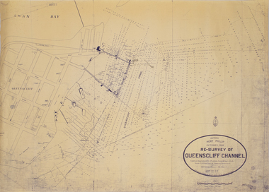 Queenscliffe Maritime Museum
Map - Survey Chart, J. P. Larkin, Re-Survey of Queenscliff Channel, 29 October 1928
A paper chart showing sounding around the Queenscliff Channel dated 1928Victoria Port Phillip October 1928, Re survey of Queenscliff Channelqueenscliff channel, surveying, navigation -
Bendigo Historical Society Inc.
Map - BOROUGH OF EAGLEHAWK SHEET 1A, 30/11/1931
Map: Borough of Eaglehawk, Parish of Nerring. Parish plan ( number 186 in Map Cupboard 1)map, bendigo, parish plan, borough of eaglehawk, parish of nerring -
University of Melbourne, Burnley Campus Archives
Map, City of Ringwood, c.1895
(1) Coloured map with Reserves, Council (other than Reserves) and Schools by City Engineer, c1985. (2) 10 copies. (3) Tracing paper copy.ringwood, gardens -
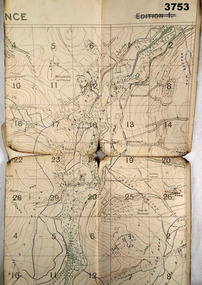 Bendigo Military Museum
Map - TRENCH MAP, FRANCE WW1, 1918
Areas covered on this map, “Coisy, Allonville, Busy, Franvillers” Item re William Alexander No 502 AIF. Refer Cat No 3746.3 for his service details.Trench map, France, Edition 2A, sheet 62D N.W, scale 1:20,000, trenches corrected to 7.5.1918, British trenches in blue.On outside drawn in purple “62D N.W 1:20,000”map, france, trench -
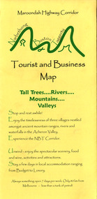 Marysville & District Historical Society
Map (Item) - Tourist and business map, Narbethong Community and Tourism Group, Narbethong Buxton Taggerty Tourist and Business Map, 04-2008
A tourist and business map of Narbethong, Buxton and Taggerty. This map was produced by the Narbethong Community and Tourism Group in April 2008. It was produced to promote the natural attractions, adventure activities and food trail from the Black Spur, through Narbethong, Buxton and Taggerty.A tourist and business map of Narbethong, Buxton and Taggerty.This publication has been produced by the Narbethong Community and Tourism/ Group (NCTG) to promote the natural attractions, adventure activities and food/ trail from the Black Spur, through Narbethong, Buxton and Taggerty./ the information provided in this publication has been supplied by the individual/ members. NCTG takes no responsibility for its accuracy./ April 2008narbethong, buxton, taggerty, victoria, australia, tourist and business map, narbethong community and tourism group, acheron valley, yarra track, wood's point, black spur, mystic mountains, the meeting of the waters, cathedral range, danico design counted cross stitch, things of sand & stone, buxton zoo nursery & oddz & enz, willowbank at taggerty, safe trek 4wd services, pnl 4wdriving, buxton trout and salmon farm, mystic mountains ski hire & outdoors, narbethong ski hire, highwood health centre, cathedral view natural therapies, narby cabinets, plants by shelian, gb timber, executive signs, rb automotive repairs, buxton car care, marysville towing & equipment hire, martyn slade building design, cathedral peak framing, black spur roadhouse & ski hire, tudor lodge roadhouse & ski hire, buxton roadhouse & persian bazzar, buxton post office general store & niche bar, igloo roadhouse, taggerty store, narby eggs, marapana agistment park, mantirri blueberry farm, carmyle farm, hazelwood hazelnuts, south cathedral lavender farm, cathedral cherries, black spur motel & caravan park, woodlands rainforest retreat, chestnut glade, black spur inn, wombat cottage, abbey lake luxury b & b spa cottages, blue views holiday cottages, camp narbethong, marapana farm stay b & b, mantirri blueberry farm b & b, little dene garden cottages, silverstream b & b cottages, nareen cabins, moondai farm b & b, south cathedral farm luxury b & b cottages, yarrolyn caravan park, sarsens rest, lomah retreat, pinjarra gardens, kingbilli country estate, henry viii manor house, buxton hotel, butters cafe of buxton, wagtail wines, little river wines, lanterns at willowbank, wirrawilla rainforest walk, wilhemina falls, the cascades