Historical information
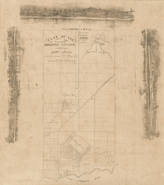
This plan records the Brighton Estate, also known as Dendy's Special Survey. In 1840 Henry Dendy, a farmer in Surrey, England acquired a "Special Survey" from the Commissioners for Land and Emigration which gave him the right to choose land in Port Phillip for the low price of £1 per acre for 5120 acres. Dendy appointed Jonathan Binns Were, as his agent, who later became a partner. Together, Dendy and Were decided on an area 5 miles south from Melbourne, bounded by North Road, East Boundary Road, South Road and to the west by Port Phillip Bay. Their Brighton Estate was first surveyed by T. S. Townsend in May 1841 and was re-surveyed by Robert Hoddle. Dendy and Were were making plans to sell the land and advertised a 30-guinea prize for the best subdivision which was to be divided into a village, marine residences, suburban and cultivation allotments, with the remainder being divided into country sections. The competition was won by H.B. Foot, who planned the village around a reserve and crescents and a 'green belt' forming the town boundary.
Physical description
Lithograph. Rectangular shaped sheet of cream paper with a central rectangular plan and three tinted drawings on the top, left and right sides printed in black ink. The title and scale are situated on the top left side of the plan, and on the top right side of the plan is a drawing of the Victorian coastline around the Bay, situating the Brighton Estate. The main section of the plan shows Port Phillip Bay at the bottom, and is bounded by North Road, South Road and East Boundary Road. The plan shows subdivisions of land, early streets including the crescent shaped Town Reserve, as well as the properties owned by landowners such as Henry Dendy, J.B. Were, George Ward Cole. The three drawings depict Brighton from the Sea, the left and top images have some buildings but are heavily vegetated with trees, while the right image is more cleared with fences and houses.