Showing 2195 items
matching documentation
-
 Ballarat Tramway Museum
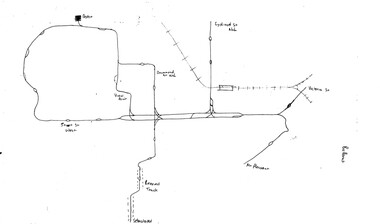
Map, Ballarat and Bendigo tram systems, 1960's or 1970's
Yields information about the extent of the Ballarat and Bendigo tramway systems and possibly has a strong association with the work of Tom Murray.Set of two hand drawn maps of the Ballarat and Bendigo tram systems, showing loops, terminus, depots and rail lines, including out of use loops and reserved track. Possibly made during the 1960's or early 1970's. Drawn on lined foolscap paper - have been torn from a pad.trams, tramways, map, drawings, ballarat, bendigo -
 Bendigo Historical Society Inc.
Map - KAMAROOKA STATE FOREST, 23/11/1910
Map: Part of Subdivision of kamarooka State Forest, Parishes of Neilborough and Whirrakee, County of Bendigo. Parish plan (number 287 in map cupboard 1)map, bendigo, subdivision, kamarooka state forest, subdivision, whirrakee -
 Bacchus Marsh & District Historical Society
Map, Trentham Parish Map 1905 Copy 1
A single page paper map showing the map for the Parish of Trentham in the Counties of Dalhousie and Bourke. A cadastral map showing parish boundaries and land ownership. The map is pasted into a bound volume containing 76 maps or plans in total. High resolution digital image stored on BMDHS computer network. Photo-lithographed at the Department of Lands and Survey, Melbourne by T.F. McGauran 22.3.05 trentham parish maps, trentham parish plan, bacchus marsh region parish plans -
 Bacchus Marsh & District Historical Society
Map, Lerderderg District Proposed Irrigation and Water Supply Trust (B) Plan Showing Proposed Works
The 1886 Irrigation Act in Victoria introduced the first legislation in Australia designed to enable the creation of a detailed scheme for agricultural irrigation. Part of the legislation saw the use of government funds for local irrigation projects. These local projects were managed by local irrigation trusts. The Lerderderg Irrigation and Water Supply Trust was formed in 1890. This map depicts the proposed area of the Trust and proposed works such as channels and weirs.Printed paper map of the proposed Lerderderg District Irrigation and Water Supply area showing proposed works. The map scale is 40 chains + 1 inch. The Lerderderg District lies within the Parishes of Korkuperrumul and Merrimu in the County of Bourke. At the top of the map above its title is the letter 'B; in capital lettering. A series of proposed channels are indicated on the map in red lines. A proposed weir site and alternative weir site are also indicated on the map. irrigation, water supply, lerderderg irrigation and water supply trust -
 Bendigo Historical Society Inc.
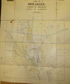
Map - JACK FLYNN COLLECTION: MOLIAGUL, 7/02/1931
Map: Township of Moliagul, Parish of Moliagul, County of Gladstone. Parish plan.map, gladstone, township, moliagul -
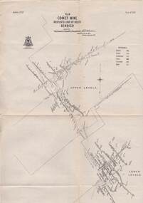
 Bendigo Historical Society Inc.
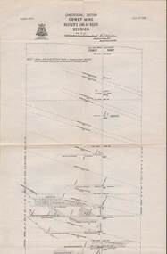
Map - STRUGNELL COLLECTION: HUSTLER'S LINE OF REEFS, BENDIGO, September 1913
Map, Hustler's Line of Reefs, Comet Mine, Longitudinal Section.Plate No.XXV1 (26).Bulletin No 33 Signed H.A.Whitelaw Underground survey Office Bendigo September 1913 Drawing shows the vertical shaft descending to over 1692 feetUnderground Survey Office, Bendigo.map, bendigo, comet mine -
Bendigo Historical Society Inc.
Map - CAMPBELL COLLECTION: BENDIGO AND DISTRICT MAPS, 16-5-29
Map. Egerton, Parishes of Egerton and Whirrakee. Scale 20 chains to 1 inch. Total area 5401 acres. Prepared in W.P.B. from A. and C.L. Plans by W.J.G. 16-5-29. To Rochester 12 miles. (number 366 in map cupboard 1)W.J.G.(W.J.Galbraith)map, bendigo, allotments -
Whitehorse Historical Society Inc.
Map, Canterbury Road, Vermont, c1970
Enlarged aerial photo of intersection of Canterbury and Boronia Roads. State Aerial Survey, Melbourne 1970 project.Enlarged aerial photo of intersection of Canterbury and Boronia Roads. State Aerial Survey, Melbourne 1970 project.Enlarged aerial photo of intersection of Canterbury and Boronia Roads. State Aerial Survey, Melbourne 1970 project.canterbury road, vermont, boronia road, vermont, mitcham road, vermont, frances avenue, vermont, nurlendi road, vermont, webb court, vermont, vermont primary school, no. 1022, aerial photographs -
 Bendigo Military Museum
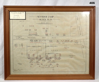
Map - PLAN, FRAMED
LT COL BENJAMIN THOMAS ROY CHADD No's 10594, VX20311, 1st and 2nd AIF. Refer 2039 for Service History also 2034P. Plan, detailing Seymour Camp Block Plan, Signals 7th Aust Div Camp 1940, re LT COL BENJAMIN THOMAS ROY CHADD. Tan coloured frame, glass front, cardboard backing, detail of camp layout, scale 160' = 1".documents - maps/plans, military history - army, frames -
Whitehorse Historical Society Inc.
Map, Bike Paths, 1995
Map in Boroondara Bulletin showing Bike paths in the City of Boroondara.Map in Boroondara Bulletin showing Bike paths in the City of Boroondara.Map in Boroondara Bulletin showing Bike paths in the City of Boroondara.bicycle paths, city of boroondara -
Bendigo Historical Society Inc.
Map - WHIRRAKEE, No date visible
Map: Whirrakee, County of Bendigo. Parish plan (number 258 in map cupboard 1)map, bendigo, parish plan, whirrakee -
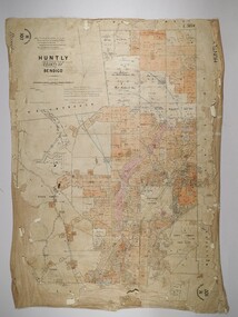 Bendigo Historical Society Inc.
Map - HUNTLY, 16/11/1903
Map: Huntly, County of Bendigo. Parish plan. Drawn by Bartholomew Becket, examined by W S Stephen 15/3/80, examined by J Walshe Sept 1903, additions H Hansford August 1903map, bendigo, parish plan, bartholomew becket, w s stephen, j walshe, h hansford, huntly -
Moorabbin Air Museum
Map (item) - AUS-RNC #2,3,4,5 ADL-MEL-SYD-BRI-TOW-CAI-PTM 1973/4
-
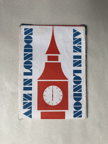 Robin Boyd Foundation
Map, ANZ in London; A map for visitors to London
walsh st library -
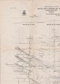
 Bendigo Historical Society Inc.
Map - UNITED HUSTLER'S & REDAN & K. K. MINES - PLAN OF UNITED HUSTLER'S & REDAN & K. K. MINES
Plan of the United Hustler's & Redan & K. K. Mines on the Hustler's Line of Reefs Bulletin No 33 Plate No XXVII. Plan shows depth of levels, Long Gully, Hustler's Line of Reefs, Lightning Hill Line of Reefs and approximate Boundary of Lease. Also mentions Comet Co. Geological Survey of Victoria emblem and signed by H S Whitelaw, Underground Survey Office Bendigo September 1913.mining, parish map, united hustler's & redan & k. k. mines, long gully, hustler's line of reefs, lightning hill line of reefs, comet co, h s whitelaw, geological survey of victoria, underground survey office -
Stawell Historical Society Inc
Map, Local Map of Stawell and District
Local Map of Stawell and Districtstawell -
Stawell Historical Society Inc
Map, Western Mining Stawell, Germania Summary Plan & Geology Western Mining Corporation, September 1988
Germania Summary Plan & Geopogy Western Mining Corporation Stawell VicGermania Summary Plan & Geology 2003-566 1:1000 mining, gold, map -
Whitehorse Historical Society Inc.
Map, Nunawading Road District, 01/04/1863
Plan of proposed new road - April 1863 & estimated expenses.Plan of proposed new road - April 1863 & estimated expenses. Scale 20 chains per inch. Proclaimed Roads 149.Plan of proposed new road - April 1863 & estimated expenses.nunawading road district, roads and streets -
Stawell Historical Society Inc
Map, Kirkella, County of Borung, 1957
Kirkella, County of Borungstawell -
Stawell Historical Society Inc
Map, Western Mining Corporation Limited, Shaft Location Plan April 1981, 1981
Western Mining Corporation Ltd Shaft Location Plan 1981 Very Large Plot Showing Contours and Streets Without names. Sheet 1 0f 2 stawell, mining -
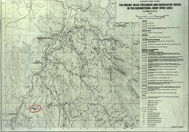 Federation University Historical Collection
Map, The Mount Read Volcanics and Associated Rocks in the Queenstown - Whip Spur Area, 1978, 1978
Contour map of the Queenstown area in Tasmania, Australia.department of mines tasmania, volcanics, mount read, queesntown, whip spur, mining, king river, gormanston, mt owen, lynchford -
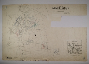 Bendigo Historical Society Inc.
Map - MEMSIE ESTATE, 26/08/1905
Map:Plan of Memsie estate, aquired under Closer Settlement Act 1904. Parish plan. Map dated 26/08/1905.map, estate, memsie estate, closer settlement act 1904. -
 Bendigo Historical Society Inc.
Map - STRUGNELL COLLECTION: HUSTLER'S LINE OF REEFS, BENDIGO, September 1913
Map, Hustler's Line of Reefs, Great Extended Hustler's Mine Plan,Plate No X (10).Bulletin No 33 Signed H.A.Whitelaw Underground survey Office Bendigo September 1913 Drawing has a table showing depths of levelsUnderground Survey Office, Bendigo.map, bendigo, great extended hustler's mine -
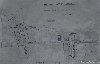 Melton City Libraries
Map, Melton Water Supply, Unknown
The development that had arguably the greatest impact in encouraging population growth in the shire during this period, was the establishment of a reliable water supply for the district. This had been a major concern of the local community for over 100 years, since the Melton township was first founded. Despite various schemes over the years to create a reliable water supply, the district was still dependent on bores, wells and tanks when the Melton Waterworks Trust was established in 1961 to address Melton’s water woes. With the opening of the Djerriwarrh Dam in December 1963, the shire’s residents finally had access to a reticulated water supply.Map shows the boundary of the area where the water will be serviced in the towncouncil -
 Bendigo Historical Society Inc.
Map - HUSTLER'S LINE OF REEFS, September 1913
Map, Hustler's Line of Reefs, Hustler's Reef & Hustler's Reef No. ! Mines, Bendigo, Longitudinal Section,Plate No.XX (20). NOTE-- Plates 4,8,13,20,26 & 31 form a Logitudinal Section from Fortuna Hustler's to Hustler's Consols Mine.Bulletin No 33 Signed H.A.Whitelaw. Drawing shows the vertical shaft descending to over 1601 feetUnderground Survey Office, Bendigo,map, bendigo, hustler's reef & hustler's reef 1 -
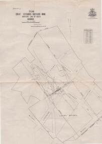
 Bendigo Historical Society Inc.
Map - STRUGNELL COLLECTION: HUSTLER'S LINE OF REEFS, BENDIGO, September 1913
Map, Hustler's Line of Reefs, Comet Mine, Bendigo Plan.Plate No.XX1V (24). Map, Bulletin No 33 Signed H.A.Whitelaw Underground survey Office Bendigo September 1913 Drawing shows upper and lower levels and appears to show samples of connecting horizontal shafts with their respective mineral contentsUnderground Survey Office, Bendigo.map, bendigo, comet mine -
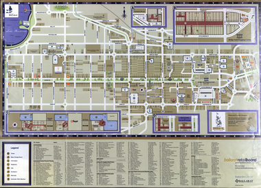 Federation University Historical Collection
Map, Eastern Ballarat (c) Retail and Business Guide, 2004
Map of Ballarat East including Brown Hill, Mount Clear and Buninyong.brown hill, mount clear, mount helen, buninyong, university of ballarat -
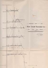 Bendigo Historical Society Inc.
Map - STRUGNELL COLLECTION: UNDERGROUND SURVEY OF MINES, BENDIGO, 29-3-01
Map, Underground Survey of Mines, New Chum Railway Co., New Chum Line, Transverse Section.A.S.Whitelawmap, bendigo, new chum railway co. -
Bendigo Historical Society Inc.
Map - BENDIGO, October 1st 1893
Map: Plan of the whole County of Bendigo, Showing areas now available for Selection (number 340 in map cupboard 1)map, bendigo, lands for selection, county of bendigo, areas available for selection -
Bendigo Historical Society Inc.
Map - MINTO, /01/1884
Map: Minto, County of Bendigo. Parish plan (number 283 in map cupboard 1)map, bendigo, parish plan, minto